-
Search

Find trips reports from 2001 and prior in the
Bow & Stern Archive
| All: by date By Title: A-Z By Author: A-Z Last 12 Months 2023 | 2022 2021 2020 2019 2018 | 2017 2016 2015 2014 2013 | 2012 2011 2010 2009 2008 | 2007 2006 2005 2004 2003 | 2002 |
By Title: A-Z...
(Not) Joe's Brook
Sunday Apr 11, 2010
2012 Creeking Clinic
Saturday May 5, 2012
2014 New Haven Ledges Race
Saturday Apr 12, 2014
2014 on the New Haven Ledges
Wednesday-Wednesday Jan 1-Dec 31, 2014
2019 Ledges Race
Saturday Apr 13, 2019
2021 Class II Clinic
Saturday-Sunday Jul 10-11, 2021
2023 Ottawa River
Wednesday-Sunday Aug 23-27, 2023
A Cold Moose
Saturday Apr 17, 2010
A Day of Hucking to end the VT Creeking weekend extravaganza...
Sunday Apr 19, 2009
A Hungry Gihon
Monday Jun 29, 2009
A Joe's Brook Trip That Wasn't
Saturday Apr 20, 2019
A Little Piece of the Cold River
Monday May 24, 2004
A Mad Flotilla...
Tuesday Apr 10, 2012
A pleasant surprise on the Tourilli
Sunday May 22, 2016
A pushy Lower Mad
Wednesday Apr 7, 2010
A weekend of Green Goodness with a splash of Gihon
Saturday-Sunday Apr 26-27, 2014
A window of things to come...
Wednesday Sep 30, 2015
After work NBW - Sooo Schweet
Tuesday May 17, 2011
All alone in the NEK
Wednesday Apr 21, 2010
Ammonoosuc
Saturday Apr 22, 2006
Ammonoosuc
Sunday Apr 29, 2007
Ammonoosuc River (NH)
Sunday May 4, 2003
Ammonusuc River
Sunday May 1, 2005
Annual PA crew to VT outting
Saturday-Monday Apr 28-30, 2012
Another Pemi/EB Pemi Trip report
Saturday May 9, 2015
Another Winooski Falls Wednesday
Wednesday Mar 27, 2019
AuSable
Sunday Jul 24, 2005
Ausable Chasm
Sunday Jun 1, 2014
Ausable Chasm
Saturday Jun 25, 2022
Baker Valley
Saturday Mar 12, 2016
Ball Mt. Brook
Saturday Apr 3, 2004
Ball Mt. Brook
Sunday Sep 19, 2004
Beaver Fest Part 2
Friday-Monday Sep 2-5, 2005
Beaver Meadow Brook
Monday Aug 30, 2004
Beaverfest
Thursday-Monday Sep 1-5, 2005
Behind the Curve...
Saturday May 3, 2014
Big Branch
Wednesday Sep 24, 2003
Big Branch
Monday May 17, 2004
Big Branch
Friday Apr 15, 2005
Big Branch - chasing the sun out of the gorge.
Friday Apr 17, 2009
Big Branch breakfast run
Wednesday May 19, 2004
Big Splash river festival flotilla
Saturday Jun 4, 2005
Big water in VT: April fools or a new big thing?
Saturday Apr 5, 2014
Bingo Creek
Wednesday Apr 14, 2004
Black River
Thursday Apr 28, 2005
Black River
Saturday Apr 11, 2009
Black River
Saturday May 7, 2011
Blind leading the Blinder
Saturday Jul 15, 2006
Board Meeting floatilla...Lower Mad
Thursday Apr 15, 2010
Boquet to Split-Rock Falls
Sunday Jul 10, 2005
Boreas River / Adirondacks
Sunday May 22, 2011
Brown Paddle
Saturday Nov 13, 2010
Browns River
Saturday Apr 6, 2002
Browns River
Saturday May 1, 2004
Browns River
Saturday Apr 16, 2016
Browns River - Westford
Wednesday Apr 10, 2013
Browns River - Westford
Tuesday Jun 19, 2018
Browns River Afternoon
Friday Apr 15, 2011
Browns River Friday evening
Friday May 2, 2014
Browns River p.m. paddle
Wednesday Apr 11, 2012
Browns River to the Lower Lamoille
Saturday Apr 24, 2010
Browns River, float in the sun
Sunday May 25, 2014
Canceled Patterson - became EB Pemi
Sunday Apr 26, 2015
Chase Brook scouting (solo)
Saturday Oct 26, 2019
Chasing flows around NVT
Saturday Jul 19, 2008
Chasing the flows (Wells-Pemi trip)
Sunday May 7, 2006
Chasing water for a Pre-Mother's Day Paddle
Saturday May 9, 2009
Cheap Thrills and the SFHWL Principle
Saturday May 30, 2009
Clarendon Gorge
Sunday May 15, 2016
Class 2 Clinic
Saturday-Sunday Jun 28-29, 2008
Class II Clinic
Saturday-Sunday Jul 15-16, 2017
Class II Clinic - Fife Brook Deerfield
Saturday-Sunday Jul 9-10, 2011
Cobb Brook
Tuesday Apr 11, 2017
Cold River
Wednesday May 26, 2004
CT RVR portion of NFCT
Thursday Aug 17, 2006
Dave Wants an Adventure
Sunday May 31, 2009
Dead River (ME) Weekend
Friday-Sunday Aug 12-14, 2011
Deerfield River Fest/Fife Brook Group
Friday-Sunday Jul 29-31, 2005
Desperately Seeking Whitewater
Monday Nov 16, 2020
Dog River
Saturday Apr 17, 2004
Dog River
Saturday Apr 18, 2020
Doing Time on the Jail Branch
Saturday Mar 24, 2012
Double Decker on Pattterson and Bingo
Saturday Jun 8, 2013
Dryway Summer Fun
Thursday-Sunday Jun 1-Jul 9, 2006
E.Branch Pemi
Friday May 27, 2005
Early season Lower Mad
Sunday Mar 22, 2009
East Br. Pemigewasset (NH)
Saturday Apr 25, 2009
Easter in the Gorge(s)
Sunday Apr 12, 2009
Easter on Patterson...
Sunday Apr 4, 2010
Eeking out the last bit of light….Martin’s Brook, Blue Angels Style
Friday Oct 15, 2010
Elmore Pond what?
Friday Jun 12, 2015
Everyone runs the Pemi
Saturday May 12, 2018
Fiddlehead before work
Wednesday Jul 10, 2013
Fire'n it up...Northfield Style in the Devil's Washbowl
Friday Oct 1, 2010
First Dee - Green River Reservoir
Friday Oct 1, 2010
First Hatch - Lower Mad
Wednesday Apr 1, 2009
First week of August Floods
Tuesday Aug 3, 2010
Full day in the Greens
Saturday May 8, 2010
Gale River (aka the river of lost gear)
Monday May 27, 2013
Gauley Fest "Back of the Hand"
Wednesday-Monday Sep 21-26, 2005
GAULEY FEST 2015
Thursday-Tuesday Sep 17-22, 2015
Geezers Weekend of Creeking
Friday-Sunday Apr 7-9, 2006
Getting After It - Fall Creeking
Saturday Oct 20, 2012
Geurilla Lower New Haven
Saturday Jun 18, 2005
Gihon & Trout
Thursday Mar 17, 2016
Gihon after work
Thursday Jun 25, 2015
Gihon River
Saturday May 4, 2002
Gihon River May 15th, 2011
Sunday May 15, 2011
Gihon River, upper and lower
Sunday Apr 4, 2004
Gihon with a crew
Sunday Jun 30, 2013
Gihon with another newbie
Saturday Jul 6, 2013
Grand Canyon 2022
Thursday-Sunday Mar 24-Apr 10, 2022
Green Narrows (NC)
Friday Mar 25, 2005
Green Release
Saturday Apr 11, 2015
Green Release-IBEX Shoot
Saturday Apr 2, 2016
Green River
Friday Oct 23, 2020
Green River Garfield to Lamoille
Friday Apr 15, 2011
Green River Release Fall 2017
Saturday Nov 18, 2017
Green River Reservoir
Sunday May 23, 2010
Green River Reservoir
Monday Jun 28, 2010
Guerilla Ammo
Sunday Apr 17, 2005
Guerrilla Mill Brook - Jericho
Tuesday Apr 21, 2015
Guide to Costa Rica
Saturday-Sunday Aug 7-22, 2004
Guide to White Nile, Uganda
Thursday-Friday Dec 16-31, 2004
High Peaks Creeks
Friday Nov 2, 2018
Hole Brothers
Saturday Sep 18, 2004
Home field advantage....NBW
Saturday Oct 21, 2006
Hot Times in the Hudson Gorge
Sunday Jul 17, 2011
How Low Can You Go...NBW
Friday Apr 2, 2010
Hudson Gorge
Saturday May 1, 2004
Hudson Gorge
Sunday May 16, 2004
Hudson Gorge
Saturday May 7, 2005
Hudson Gorge
Saturday May 6, 2006
Hudson Gorge
Saturday Jul 8, 2006
Hudson Gorge
Saturday Apr 23, 2016
Hudson Gorge - If you release it, they will come...
Sunday Jun 10, 2007
Hudson River
Sunday Sep 30, 2007
Hudson River Gorge
Saturday May 5, 2007
Hudson River Gorge
Sunday Oct 10, 2010
Hudson River Gorge
Sunday Jun 10, 2012
Hudson River Gorge
Sunday Jun 16, 2019
Hudson Solo(Reparius to Glen)
Sunday May 6, 2007
Hudson/Hudson Gorge/Schroon (NY)
Saturday May 17, 2003
Huntington
Saturday Jan 6, 2007
Huntington
Saturday Apr 4, 2009
Huntington - Audubon to Jonesville
Sunday Apr 10, 2011
Huntington River
Saturday Mar 30, 2002
Huntington River
Saturday Mar 29, 2003
Huntington River
Sunday Apr 27, 2003
Huntington River
Saturday Apr 3, 2004
Huntington River
Saturday May 1, 2010
Huntington River
Sunday Apr 21, 2013
Huntington River
Saturday Apr 4, 2020
Ice Breaker "Season Opener"
Saturday Feb 25, 2017
Independence Paddle Party
Friday-Monday Jul 1-4, 2005
Independence Paddle Party Part Deux (Long)
Friday-Tuesday Jun 30-Jul 4, 2006
Jay Brook on the fly...
Sunday May 4, 2014
Joe's Brook
Saturday May 18, 2002
Joe's Brook
Saturday Nov 1, 2003
Joe's Brook
Sunday Apr 18, 2004
Joe's Brook
Saturday May 25, 2013
Joe's Brook
Saturday May 17, 2014
Joe's Brook
Sunday Apr 19, 2015
Joe's Brook
Saturday Apr 22, 2017
Joe's Brook (Joe's Pond to Morses Mills)
Sunday Apr 13, 2003
Joe's Brook (Massacre)
Sunday Oct 16, 2005
Joe's Brook - 100 Foot Fever
Monday Nov 1, 2021
Joe's Brook - Low Boatable
Monday Oct 23, 2023
Joe's Brook - Medium
Tuesday Apr 25, 2023
Joe's Brook - One Perfect Day
Saturday Apr 21, 2007
Joe's Brook - Why Wipe that Grin off Your Face?
Sunday Aug 3, 2008
Joes at Low Water
Saturday Apr 9, 2016
Joes including the BFS...
Saturday Apr 18, 2009
Juniper Island Paddle
Saturday Jul 12, 2008
Kennebec
Thursday Jun 10, 2004
Lake Carmi
Sunday Jul 4, 2010
Lamoille
Saturday May 19, 2007
Lamoille (Bootleg)
Thursday Jun 10, 2004
Laps on the Gihon
Sunday Jun 4, 2006
Le Taureau / Le Malbaie
Saturday-Sunday Aug 7-8, 2004
Lewis Creek
Saturday Apr 18, 2015
Little River
Friday May 6, 2011
Lookin' for the Flow
Saturday Apr 17, 2010
Lower (not Upper) Mad
Sunday Apr 3, 2011
Lower Hudson
Sunday May 2, 2004
Lower Hudson
Sunday May 22, 2005
Lower Hudson
Saturday May 27, 2006
Lower Hudson
Monday Apr 27, 2009
Lower Hudson
Saturday May 16, 2009
Lower Hudson (NY)
Sunday May 18, 2003
Lower Lamoille
Wednesday Apr 24, 2002
Lower Lamoille
Sunday Apr 11, 2004
Lower Lamoille
Wednesday Apr 21, 2004
Lower Lamoille
Sunday Apr 17, 2005
Lower Lamoille
Saturday Apr 8, 2006
Lower Lamoille
Sunday Apr 1, 2007
Lower Lamoille
Sunday Apr 6, 2008
Lower Lamoille
Saturday Apr 11, 2009
Lower Lamoille
Saturday Apr 10, 2010
Lower Lamoille
Wednesday Jun 8, 2011
Lower Lamoille
Sunday Apr 1, 2012
Lower Lamoille
Sunday May 6, 2012
Lower Mad
Saturday May 4, 2002
lower mad
Friday Mar 27, 2009
Lower Mad
Wednesday May 13, 2009
Lower Mad
Saturday Apr 9, 2011
Lower Mad
Saturday Apr 30, 2011
Lower Mad
Saturday Mar 24, 2012
Lower Mad
Sunday Apr 9, 2017
Lower Mad (open for business)!
Tuesday Mar 10, 2020
Lower Mad 4/18/2007
Wednesday Apr 18, 2007
Lower Mad Call in Sick run
Tuesday Oct 26, 2010
Lower Mad River
Sunday May 19, 2002
Lower Mad River
Wednesday May 11, 2011
Lower Mad River
Wednesday May 9, 2018
Lower Mad Run
Wednesday May 22, 2013
Lower Mad Run
Wednesday May 22, 2013
Lower Mad, early spring run
Sunday Mar 11, 2012
Lower Moose River, VT
Saturday Oct 13, 2007
Lower New Haven
Saturday Apr 5, 2008
Lower New Haven
Wednesday Apr 13, 2011
Lower New Haven
Wednesday Apr 20, 2011
Lower New Haven
Wednesday May 9, 2012
Lower New Haven
Wednesday Apr 15, 2015
Lower New Haven: we have water!
Saturday Oct 19, 2019
Lower Paul Stream - Episiode III
Saturday Nov 6, 2010
Lower White River
Saturday Mar 30, 2013
LowerMad River
Wednesday Apr 30, 2014
Mach 7 With Your Hair On Fire - Hancock Brook (NBW)
Friday Oct 15, 2010
Mad above Warren
Saturday Apr 11, 2015
Mad after work....
Wednesday May 5, 2010
Mad River
Wednesday May 16, 2007
Mad River
Wednesday May 4, 2016
Magalloway R. (ME)
Friday-Sunday Jul 5-7, 2002
Magalloway Weekend (ME)
Friday-Monday Aug 29-Sep 1, 2003
Maine
Friday-Sunday Aug 13-15, 2004
Maine Weekend
Thursday-Sunday May 4-7, 2006
Malbaie/Penobscot
Thursday-Tuesday Aug 11-16, 2005
Maquam Shore - Champlain
Wednesday Jun 23, 2010
Mascoma River
Saturday Apr 13, 2002
Mascoma River (Lebanon, NH)
Sunday Mar 30, 2008
Mascoma River - from Mascoma Lake
Saturday Apr 7, 2018
May 2013; There was water on the Moose
Saturday-Sunday May 11-12, 2013
Memorial Weekend in Maine (Dead River)
Saturday-Sunday May 24-25, 2008
Mettawee River (NY)
Saturday May 10, 2003
Micro-Phun in the Dark and a trip to the Rustic
Thursday Jul 24, 2008
Midd Gorge
Tuesday May 3, 2016
Midd Gorge in the Sun
Monday Apr 24, 2017
Middlebury Gorge
Saturday Nov 1, 2003
Middlebury Gorge
Wednesday Apr 28, 2004
Middlebury Gorge
Friday Nov 20, 2015
Midnight Safari on Little Averill Lake
Thursday Sep 25, 2008
Mill Brook
Tuesday May 2, 2017
Mill Brook (eastern VT)
Monday Apr 6, 2009
Mill Brook (Jericho)
Tuesday Apr 8, 2008
Mill Brook, Brownsville to Windsor
Thursday Apr 27, 2017
Mill Brook, Brownsville, VT
Friday Apr 22, 2011
Mill Brook, Jericho
Saturday Oct 8, 2005
Mill Brook, Jericho
Saturday Jun 10, 2006
Mill Brook, Jericho
Thursday May 17, 2007
Mill Creek, "Easy Street" section (Danby)
Monday Dec 1, 2003
Mill River (Clarendon Gorge)
Wednesday Nov 19, 2003
Mill River - Clarndon Gorge
Friday Apr 17, 2009
Minister Brook
Sunday Apr 14, 2002
Missisquoi #1
Saturday Sep 9, 2017
MIssisquoi in North Troy (MINT)
Sunday May 22, 2022
Missisquoi NWR
Saturday Jun 16, 2007
Missisquoi Opener
Saturday May 2, 2015
Missisquoi release
Sunday Nov 6, 2016
Missisquoi Release #2
Saturday May 30, 2015
Missisquoi Release Minimum Study
Sunday May 4, 2014
Missisquoi River @ Sheldon Springs - Darn Low
Saturday Apr 14, 2007
Missisquoi River Sheldon
Wednesday Jul 7, 2010
Missisquoi, North Troy
Saturday Apr 28, 2012
Montreal: Expo 67, Lachine & Valley Field
Saturday-Sunday Jun 19-20, 2004
Moose Fest - Lower Moose
Saturday Oct 16, 2004
Moose Fest 2006
Thursday-Friday Sep 14-15, 2006
Moose River
Sunday Apr 24, 2005
Moose River
Wednesday Sep 5, 2012
Moose River, St. J
Sunday Apr 5, 2009
Moose River, Victory, VT
Monday Mar 30, 2009
More NEK action
Saturday May 1, 2010
My personal caranage
Saturday Oct 15, 2005
N. Branch Cold River / Cold River
Monday Apr 30, 2018
N.Br.Winooski/Gihon
Tuesday Oct 28, 2003
NB Lamoile
Saturday Apr 9, 2005
NBL dressed in Whites....
Sunday Feb 28, 2016
NBL Gorge and Slides
Sunday May 13, 2012
NBW - Green Leaves & Short Sleeves
Wednesday Jun 10, 2015
NBW after work #2
Wednesday Jul 1, 2015
NBW and Lower Hancock
Monday Mar 19, 2012
NBW before work
Monday Jul 20, 2015
NBW in the Spring...kind of
Wednesday Apr 16, 2014
NBW in warm weather
Friday Jun 28, 2013
NBW Season Opener - SOLO
Saturday Mar 17, 2012
NBW with no one to share it with
Tuesday Jun 6, 2017
New England Creeker Weekend
Thursday-Sunday Apr 8-11, 2010
New Haven
Sunday Mar 31, 2019
New Haven / Lower Mad
Saturday Apr 17, 2004
New Haven and Middlebury
Monday Oct 4, 2010
New Haven Ledges
Saturday Sep 28, 2002
New Haven Ledges
Wednesday Apr 17, 2013
New Haven Ledges
Sunday Mar 28, 2021
New Haven Ledges at a boat breaking low level
Saturday Oct 23, 2010
New Haven Ledges Race
Saturday Apr 18, 2015
New Haven Ledges Race
Saturday Apr 16, 2016
New Haven Race
Sunday Apr 5, 2009
New Haven Race
Saturday Apr 9, 2011
NH Race 2010
Monday Apr 19, 2010
No-Shuttle Boreas
Saturday May 13, 2006
North Br. Piscataquog, Weare, NH
Saturday Oct 15, 2016
North Branch Lamoille
Saturday Apr 3, 2010
North Branch Lamoille
Saturday Jun 29, 2013
North Branch of the Lamoille
Saturday Sep 28, 2002
North Branch of the Lamoille
Sunday May 1, 2011
North Branch of the Lamoille
Sunday Apr 12, 2015
North Branch of the Lamoille
Saturday Apr 25, 2015
North Branch of the Lamoille River
Saturday May 3, 2003
North Branch Winooski after work
Tuesday Apr 12, 2016
North Branch Winooski at a good level...
Sunday May 26, 2013
Northern Sampler...
Sunday Apr 12, 2015
Novice Whitewater Clinic
Friday-Sunday Jul 12-14, 2002
One step ahead at Moosefest
Saturday-Sunday Oct 17-18, 2015
Ottawa 2011
Friday-Monday Sep 2-5, 2011
Ottawa Paddle Party No 2
Friday-Sunday Aug 12-14, 2005
Ottawa River
Saturday Sep 4, 2010
Ottawa River
Friday-Monday Aug 31-Sep 3, 2012
Ottawa River
Friday-Monday Sep 4-7, 2015
Ottawa River
Friday-Monday Sep 1-4, 2017
Ottawa River
Friday-Monday Aug 30-Sep 2, 2019
Ottawa River
Friday-Monday Sep 3-6, 2021
Ottawa River
Wednesday-Sunday Aug 24-28, 2022
Ottawa River - August 2007
Thursday-Sunday Aug 9-12, 2007
Ottawa River - Labor Day Weekend
Friday-Monday Sep 2-5, 2016
Ottawa River 2009
Friday-Monday Sep 4-7, 2009
Ottawa River Weekend
Friday-Monday Aug 30-Sep 2, 2013
Otter Creek
Sunday May 18, 2003
Otter Creek
Monday May 31, 2004
Otter Creek
Tuesday Jun 8, 2004
Otter Creek Falls -- at night!
Wednesday Sep 10, 2003
PA to VT Part 8
Friday-Monday Apr 29-May 2, 2016
Paddling the Laurentians - Doncaster, Du Nord & Noire
Saturday-Sunday Apr 30-May 1, 2016
Paddling thru Middle Earth
Friday Apr 21, 2017
Paterson at a low level (Shocker)
Tuesday Jun 23, 2015
Patterson / Bingo / Patterson
Sunday Jul 18, 2021
Patterson and Top New Haven
Sunday Jun 28, 2015
Patterson Brook (and people to boat with)
Wednesday-Sunday Apr 25-29, 2018
Patterson Brook - padded out.
Wednesday Apr 23, 2008
Patterson Drenched in Sun!
Sunday May 17, 2009
Patterson Dressed in Whites...
Saturday Dec 22, 2012
Paul Stream
Sunday Oct 26, 2008
Pemigewasset
Saturday Jul 9, 2005
Penguin Plunge
Saturday Feb 10, 2007
Petawawa River
Friday-Sunday May 17-19, 2013
Plan B, Wells River
Sunday May 16, 2010
Post Chrismas Gihon...
Sunday Dec 27, 2015
Post Work Mad....
Monday Apr 8, 2013
Poultney
Saturday May 12, 2007
Poultney
Saturday Oct 30, 2010
Poultney
Sunday May 15, 2011
Poultney River
Saturday May 11, 2002
Poultney River
Tuesday Sep 30, 2003
Poultney River
Friday May 15, 2015
Pre Work Patterson...
Wednesday Apr 10, 2013
Quebec
Friday-Sunday Jul 9-11, 2004
Quebec done right
Saturday-Sunday Aug 15-16, 2015
Rapid
Friday-Saturday Jul 24-25, 2015
Rapid River
Sunday Jul 25, 2010
Reintroduction...
Monday Jun 6, 2016
Ridley after work...
Tuesday May 6, 2014
Ridley Brook
Tuesday May 14, 2002
Rouge River, Quebec
Sunday Jul 29, 2007
Routing Gnar Stout Eardips at Beaverfest 2015!!!
Saturday-Monday Sep 5-Nov 9, 2015
Running late in Quebec
Saturday-Sunday Aug 12-13, 2017
Sacandaga
Monday May 28, 2007
Saranac in May
Sunday May 13, 2018
Saranac in May (episode 1)
Sunday May 18, 2014
Saranac River (NYS) to Redford
Sunday Apr 17, 2011
Saranac River to Redford (#1)
Saturday Apr 29, 2017
Saranac take 2 in 2013
Sunday Jul 7, 2013
Schroon River
Sunday Apr 11, 2004
Scoping out new water on the upper Winooski
Monday Nov 12, 2012
Season Opener on Stoney
Thursday Apr 10, 2014
Sheldon Springs/Missisquoi Release
Saturday Nov 2, 2013
Shepard Brook - Trick or Treat?
Sunday Oct 31, 2021
Shepard Brook, on our day off
Tuesday Apr 11, 2017
Short Sleeves and Green Leaves...A solo NBW.
Monday Jun 6, 2016
Snagging a few western slope gems on the drop
Sunday May 21, 2006
Sometimes we do good - Flint Brook
Tuesday Jun 23, 2015
South Hero to Valcour Island
Saturday May 15, 2010
Speaking of the West...
Saturday Apr 28, 2007
Speed Run on Patterson Brook
Friday May 29, 2009
Spring Green Release
Sunday Apr 23, 2017
Spring Moose
Saturday-Sunday May 26-27, 2018
Stoney Brook (VT)
Sunday Mar 9, 2008
Stony Brook - Dave's Back Yard Babe
Monday Jul 17, 2017
Stony Brook - in the shadows
Monday Jun 8, 2015
Summer Rolling
Sunday-Thursday Jul 1-Aug 30, 2012
Sun, Rain & Waterfalls...
Thursday May 6, 2010
Swift Water Rescue Course
Saturday-Sunday Jun 26-27, 2004
Swiftwater Rescue Clinic
Saturday May 10, 2008
Taming the East Branch Pemi
Saturday May 25, 2019
Taureau
Saturday Jul 9, 2005
Taureau (Jacques-Cartier River)
Saturday Jun 23, 2012
The (Friendly) Wells River
Saturday Apr 24, 2021
The Baker Valley
Sunday Jun 3, 2012
The Great Canadian Epic part 1: Tewkesbury and the Mistassibi
Saturday-Monday Aug 10-12, 2013
The Great Canadian Epic part 2: The Magpie River
Wednesday-Tuesday Aug 14-20, 2013
The Green was gold
Saturday Nov 5, 2016
The Jazz Festival Float
Sunday Jun 8, 2003
The Ledges
Saturday Apr 17, 2021
The Mad Goes Vert (ical)
Sunday Aug 28, 2011
The many faces of Patterson Brook
Tuesday Jul 2, 2013
The Mighty Nully (Nulhegan)
Saturday May 5, 2007
The NBW after work in the Dark grinning ear to ear....
Tuesday May 8, 2012
The river I still can't spell correctly
Sunday Jun 15, 2014
The Running of the Bull
Saturday Jun 28, 2014
The Upper Moose
Saturday Oct 2, 2010
The Vermont Bob Sled Run...
Monday Apr 14, 2014
The Vermonter and the Spruce
Saturday May 21, 2016
The West River Release - Fall 2012
Saturday Sep 29, 2012
Trout River
Wednesday Jun 11, 2008
Two November Green Releases...
Saturday-Saturday Nov 7-21, 2015
Upper Browns River - Underhill
Friday Oct 1, 2010
Upper Huntington
Thursday Dec 3, 2009
Upper Lamoille
Saturday Apr 13, 2002
Upper Mad
Sunday Apr 4, 2004
Upper Mad
Thursday Sep 9, 2004
Upper Mad
Wednesday Apr 2, 2008
Upper Mad
Saturday Mar 19, 2011
Upper Mad
Wednesday Apr 27, 2011
Upper Mad (again)
Wednesday Mar 31, 2010
Upper Mad (Improv)
Sunday Apr 13, 2014
Upper Mad River
Wednesday Apr 9, 2008
Upper Mad season opener
Sunday Mar 21, 2010
Upper Mill Brook (West Bolton)
Sunday Jun 3, 2007
Upper Moose
Tuesday May 8, 2012
Upper Moose River, Victory, VT
Saturday Apr 26, 2008
Upper New Haven
Sunday Apr 21, 2019
Upper North Branch Lamoille
Thursday Apr 17, 2014
Upper Pemi
Saturday Apr 29, 2017
Upper Pemi / East Br. Pemi
Wednesday-Thursday May 6-14, 2015
Upper Pemigewasset
Thursday May 6, 2004
Upper Saco R. (NH)
Saturday Apr 10, 2021
Upper White
Friday Aug 13, 2004
Upper White River - Stockbridge to Bethel
Saturday Mar 30, 2019
Upper White Stockbridge to Gaysville
Saturday Oct 16, 2010
Upper/Lower Mad
Saturday Oct 9, 2010
US Olympic Trials / West Virginia
Friday Apr 2, 2004
VPC Novice Clinic 2017
Saturday-Sunday Jun 10-11, 2017
VT to NY
Saturday-Sunday Apr 15-16, 2006
Wardsboro Brook/Ball Mtn Brook
Saturday Nov 29, 2003
Warner River
Monday May 5, 2008
Warner River (NH)
Friday Sep 3, 2021
WB Deerfield
Monday May 24, 2004
WB Deerfield/Cold (MA)
Sunday Dec 26, 2004
Weekend in Fantasy land Maine
Friday-Sunday May 27-29, 2005
Wells Laps...
Saturday Mar 26, 2016
Wells River
Saturday May 16, 2009
West and East Ausable Rivers, NY
Sunday Apr 18, 2010
West Br. Ompompanoosuc
Saturday Oct 16, 2010
West Branch Deerfield
Saturday Dec 27, 2003
West branch of the Little River
Saturday Dec 21, 2002
West Fest 2013
Saturday Sep 28, 2013
West R. Weekend
Saturday-Sunday Sep 21-22, 2002
West River
Saturday Sep 25, 2004
West River Release
Saturday Oct 10, 2015
West River release flows, 2014
Saturday-Sunday Sep 27-28, 2014
West Virginia General Overview
Friday-Friday Mar 14-21, 2014
West: Spring 2006
Saturday-Sunday Apr 29-30, 2006
Where's the water?
Wednesday Sep 19, 2012
While everyone was at the West...
Sunday Apr 29, 2007
White -> Lamoille
Sunday Apr 25, 2004
White from Royalton to West Hartford
Saturday Jul 24, 2010
White R. to West Hartford
Saturday Aug 9, 2008
White River
Sunday Apr 7, 2002
White River
Saturday Apr 12, 2003
White River
Saturday Apr 17, 2004
White River
Saturday Apr 16, 2005
White River
Saturday Apr 15, 2006
White River
Sunday Apr 22, 2007
White River
Friday Apr 24, 2009
White River
Sunday Apr 24, 2011
White River - Stockbridge to Bethel
Saturday Apr 26, 2014
White River - Stockbridge to Bethel
Saturday Apr 11, 2015
White River - Stockbridge to Bethel
Saturday Apr 15, 2017
White River Watershed Not So Micros
Friday Mar 30, 2018
Whitewater and a Wedding
Thursday-Saturday Jul 16-Sep 19, 2015
Whitewater Weekend - PA to VT, Pt VI
Friday-Monday Apr 12-15, 2013
Wild Br. of Lamoille
Saturday Jun 18, 2005
Winhall Brook during West Fest
Sunday Apr 29, 2007
Winooski Falls
Wednesday Apr 18, 2012
Winooski Falls, first time out in 2019
Wednesday Mar 20, 2019
Wolcott Rapids on the Lamoille
Saturday Apr 13, 2013
Wood Removal
Saturday Nov 27, 2010
WV Extravaganza - 2015
Friday-Saturday Mar 20-28, 2015
You call it the Mill, I'll call it the Clarendon.....
Saturday May 10, 2014
By Title: A-Z...
(Not) Joe's Brook
Sunday Apr 11, 2010
A.J. traveled down Rt. 5 from East Burke to East Barnet early Sunday morning to get a visual on Joe's Brook, which was "just a trickle". Plan B options included the Mettawee, the Poultney, and the New Haven Ledges. None of these appealed to A.J., but we agreed we'd run Joe's together - one way or the other - before the end of April. Moving on, I made the call on the message board to meet up in Bristol at 11 am to run the ever-popular NH Ledges.
After gearing up at the take-out, we pulled over on the way up to the put-in to examine the best route around the "pin rock" above Play Pen. It was good timing, for us, as another group of boaters was in the middle of a real-life rescue of a kayaker vertically pinned in that exact spot. Noone was hurt, but I wish I had taken a couple of pictures to make others aware of this hazard at low water.
The water was sparkling in the sunshine, and the level held steady at ~375 CFS all day - low and technical but definitely boatable. It got above 50 degrees, tempered by a strong/chilly west wind once you were all wet. There were swims at Lost Legs and the Play Pen, but in each case a rope was tossed to keep the swims short. I impressed a father/son spectating at Toaster by attempting it in an open canoe, and moreover hitting the boof/tongue perfectly and landing upright (and virtually dry) in the pile at the bottom - my first completely clean and upright run of Toaster!
I will post a few Paddle Pix for the day.
As kayakers go, Jim, Jamie, Eric, and Pete are good eggs. I'd paddle again with them...any time ;o)
2012 Creeking Clinic
Saturday May 5, 2012
Organizer: AJ Seibel, Ryan McCall, Alden Bird
Difficulty: advanced WW
Level: medium
Author: AJ Seibel
This marked the first time the VPC has hosted a clinic specializing in creek boating. The clinic turned out to be a great success, minus one cracked boat. Students learned the basics of steep creeking, advanced stroke concepts, and capped the day with a special treat, courtesy of the O-Face hole!
Rain brought the river up to a fluid 240 or so CFS for the clinic, and Mother Nature graced us with sunshine that got better and better as the day went on. The class began with stroke technique for draw strokes and a few slalom-inspired draw stroke drills courtesy of Alden Bird. Students then ran the first drop, Brett's Mom, with no paddle stroke to get a feel for entry speed and angle on a drop and how to interact with the various currents. Then, we all hiked back up to try it again! The second attempt taught the basics of the "Boof" stroke, and completing the drop with a strong forward stroke at the bottom. Then, we ran it again!! The 3rd time down the drop worked across the current, and had students catching the RL eddy as though it was a "last chance" eddy on a tight creek. Everyone handled these three exercises very well!
Next up was our first run of "The Sweetness". This drop introduced hydraulics, cross currents, and boof ledges. A few folks didn't navigate the cross current very well, and John decided that the drop was so easy to run forwards that he did a rock spin and attempted a back boof. A snappy roll finished off his freestyle approach to class IV!
One of the main topics for the day was about slowing down the river, catching eddies, and having strong entrances to the drops. In "Labyrinth", the class practiced eddy catches and navigated the exit slide to thread between a couple of sticky holes. Shortly after this drop comes "Elevator Shaft" and all students got to practice their boof technique again on a clean 3' drop towards river left. Another run of the same rapid bounced students down a fun slide on RR.
Then came the fun... El Salto Falls. This is a chunky 12' cascade on river right, and we had all students approach it as a slide. Entry angle, loose hips and a neutral body position were emphasized. A few folks were spun sideways while dropping down the cascade, but all rolled up at the bottom. Most folks had better lines than expected, and it was the biggest drop to date for many of the participants. Alden showed us how awesome the river left line can be. Twice.
With everyone upright and smiling, we headed downstream through the boogie and eddied out at the top of "Tantra", the final rapid in this beautiful stretch of river. Tantra has two lines, one RR and one RL. The RR is more straightforward, simply requiring a point and shoot (and some balance) to get down the two-pitched slot. The RL line is more involved, requiring a boof over a seam, and a hard charge to river center or a big hit in the O-Face hole at the bottom. The RR line was, once again, not sporting enough for John and he decided to do yet another rock spin and run that drop backwards as well! Paul blurted some profanities while pitoning on the RR line, and folks who chose to run the RL line did so very smoothly, or with some fun-for-spectators carnage.
This concluded the morning session, and we all headed back to the put-in for a quick lunch.
After lunch we got back on the river to continue exercising the participant's newfound skills - changing the lines on the first drop, and working on turning boofs in the second drop. A fun little boof was introduced in labyrinth, with a RR exit over the "race line" to avoid the hole at the bottom. Everyone styled El Salto again - some ironing out the kinks from their morning attempts of the run. Downstream we went through the boogie towards Tantra, and then the fun began!
For the last run of tantra for the day, everyone chose to run the more difficult RL line. The seam/hole at the top served up a nice helping of roll practice, and the hole at the bottom (the O-Face hole) provided multiple (close to 70% of the class!!) swiftwater rescue training moments. The hole (and eddy that so kindly feeds you back into the hole) can be very sticky - at any level. It was a fine finish to an otherwise perfect day - reminding everyone that creeks can be intense, and the river is not always on your side.
With gear recovered and smiles still on everyone's faces, we concluded the day with a BBQ and some fine Vermont ales.
Personally, I can't wait to be part of the next creeking clinic. Its awesome seeing class III/IV boaters step it up and learning how to work with the river to make class IV fun and manageable. Thanks to all of the participants and instructors, and to all of the photo/video hounds that documented our every move!
Until next time... boof!
2014 New Haven Ledges Race
Saturday Apr 12, 2014
In it's 6th year the New Haven Ledges Race has come into it's own. Folks around New England know about it, Boaters from north of the boarder come down to race it. Sponsors want to be involved and overall it is a really great fun event.
This year may have been the best one we have had yet. We initially had scheduled it for the first Saturday in April only to have to bump it back a weekend to let the ice break loose from the river. Our timing was as good as it gets. The river had come up high the week before and cleared the ice and we had nice high flows the day before the race and then it came back down to a reasonable flow that met the needs of racers of all abilities.
We had 42 racers in all. 6 of them raced in both the Long boat and Creek Boat categories. A large percentage of the field of racers were from Quebec. VT brought the usual strong contingency of local boaters, but ultimately it was a racer from the past that showed up this year to turn the heat on and win the overall Creek Boat and Long Boat categories. Tino Specht topped past winners, Gilbert, Pritchard and Brown taking home the Lion's share of the prizes. The best part of this was that it seemed as though no one really cared about the prizes, because the prize was that everyone was out on a sunny 70 degree April day at the Ledges running laps and there just happened to be a ramp and finishline for folks to collect their times.
The New Haven Race - laid back grass roots VT event. Pure fun - the way boating in Vermont should be.
Not to forget - our volunteers were huge this year, Brock drove shuttle, John - brought the ramp and directed traffic, Chris was a multipurpose guy all over the place, Paul assisted with the finish Danica kept time and crunched numbers for us, Andrew took photos and worked safety, Alex did the same, Will was the race day logistics man - safety, time keeping and really making sure our gears were turning as the should. Nick put in a ton of pre-race time helping to secure sponsorship and pre race logistics. So a huge thanks to all that helped out in some way or another.
Also - Thanks to our sponsors. Many companies provided prizes and most importantly the Vermont Paddlers Club for their continued support financially and with Volunteers.
The New Haven Ledges Race - Just another excuse to spend a day on one of the best stretches of Whitewater in the Northeast!
2014 on the New Haven Ledges
Wednesday-Wednesday Jan 1-Dec 31, 2014
Growing up on a south-facing hillside in Hinesburg, the crescent skyline of Lincoln Ridge was a familiar sight for the 18 years I lived there, or the time I spent living with the same view in Charlotte. Hiking along it one finds a remarkable and relatively rare microclimate of consistent mist, rain and heavy moss growth, with it's considerable, orographically-enhanced runoff running east into Vermont's most well-known whitewater river, the Mad, and to the west into a slightly less well known but more notable watercourse, the New Haven River. I have hiked many times on Lincoln Ridge, but am equally familiar with it's western drainage, my parents having taken me swimming at Bristol Falls and Circle Current (among other swimming holes) since I was young.
A few other things: First, Mount Abraham and Mount Ellen (the 3rd and 5th highest in the State of Vermont) sit at Lincoln Ridge's southern end, both somewhat conical peaks. A tight notch, Lincoln Gap, is found just to Mount Abe's south and divides Lincoln Ridge from the Breadloaf Wilderness (also a relatively high-elevation area). Second, this topography captures the local storm tracks and enhances the precipitation, to the tune of 60 or 70 inches of liquid equivalent per year. No wonder this river is so popular with paddlers, with consistent spring flows and at least one runnable weekly day (on average) July through December. Third, this topography is largely responsible for the massive 1998 flood, when the river rose to 20,000 cfs. After that, I saw the river as an elegant, brutally powerful feature, more than just a swimming spot. But of course an 11-year old would not really think of it as something to paddle. Paddling was what you did with you're folks on Lewis Creek, not the waterfall-studded New Haven.
Of course that was then and this is now, and it wouldn't really be easy to describe what the river's steepest section, the New Haven Ledges, really is about. It's a whitewater run - a quality one for sure - a training river, a proving ground, and a sort of home-away from home for many Vermont boaters. But rather than waste time delving into some sort of conceptual, spiritual or essential nature of something that is just for sport (this has been done to no end by creative and ambitious authors), I'd like to list a couple milestones from 2014.
Things got off to a late start in April - a start more typical of the 1990's or 2000's rather than the globally-warmed 2010's. I think we got about a week of training in before the New Haven Race. Which, by the way, was awesome for 2014. Past years have seen levels that were pretty high and pretty low, and weather ranging from mediocre to wonderful. But in 2014 things pretty much aligned and we had perfect racing flows of about 600 cfs on the gauge.
The following week saw a heavy rain-on-snow event and the river rose to many thousands of cfs. Things move around a bit. Chute by the Road now has a serious FU rock at low water, and is now called Sh*t by the Road. Some say Oh By the Way has gotten more difficult at medium levels, and my numerous personal trips through the Schott Slot confirm this, though I can't really say why it's gotten harder. Scott G kept himself in his boat in Roostertail at the race this year while a Quebecker swam - so I don't know about changes there, but Playpen cleaned up a lot, and now has a fantastic greenwater boof at the top. Finally and most importantly, the much-maligned slab of rock that All-American Boof lands on dropped 8 inches and even at low water this landing is soft and friendly. This riverbed changes a lot. It even changed a bit in December, for the better I think- and will likely change at ice-out this coming spring, for the better I hope. But it will be good regardless.
2014 saw a couple new faces here. Justin Worth, Eric and Anders Newbury, Felix Touzin and Andy Lockey got their first runs here, and Ryan McCall and Paul Dawson returned after a several-year hiatus. Culley, a hard-whitewater-right-off-the-couch specialist moved in and randomly confused us with his California license plates one day. And no doubt several other people were introduced to this fine run. Apologies to whoever I omitted from this list. As Scott G once said "if there is anything as good as running a rapid for the first time, it's seeing someone run a rapid for the first time".
Unfortunately some valued crew members also left - Daphnee and Nick moving to the desert southwest. We no doubt miss them, but were pleased to see that Nick, one of our own and a New Haven Ledges regular ran the mother of all rivers, the Grand Canyon of the Stikine. Also, Christian moved somewhere, I am not sure where...
But this really just goes to show how unique each day here is - the exact water level, the configuration of the riverbed, the weather, who you're paddling with and whatever happenings might occur off the river. It is a one-time event never to be repeated again in the entire universe. Yet somehow every season is rewarding. Here's to 2015 on the New Haven.
2019 Ledges Race
Saturday Apr 13, 2019
April 13, 2019…. We set that date back in October of 2018 as when we wanted to hold the 11th annual New Haven Ledges Race on the New Haven River in Bristol, Vermont. We always set a date for around the beginning of April so we can catch the snow melt bubble coming out of the Green Mountains. Last year we got temps in the 20s and sleet. The year before it was in the 20s and snow. This year……Jackpot! We got a smidge of rain the night before and then it got sunny and temps drove toward 70. Some years you miss it and some you hit it on the head. This year we knocked it out of the park. Some of the best weather and water levels we have ever seen. I should have played the lottery.
The race has really grown into the season opener here in New England and this year we saw our highest number of early registrations. The day before the race there was a flurry of online sign-ups that put us at 47 racers pre-registered. That made for an interesting morning of the race. Since 2012 we have set the max race registration at 60 racers. We have never gotten to that number. Doing the math it works out pretty nicely for each racer to get two laps over the course of the day. It is also a good number to split the field to set half the racers in safety and the other half on deck for their race lap racing, doing this both in the morning and in the afternoon. For this year we were rapidly approaching our max number of 60 and “day of registrants” were still rolling in before our pre-race meeting. Things happen for a reason though…a number of racers weren’t comfortable with the meaty levels for race laps and decided to turn in their bibs. This opened up the opportunity for others waiting to sign up. In the end we handed out 49 bibs to racers.
Our morning started off wet and wild as we sent racers 26–49 down through the course to get to designated safety spots. One of the safety boaters on his way down to his designated safety location got munched in the second ledge about 25 yards below the start ramp. Our team went into action immediately to pull the paddler and his boat from the river. Not even racing yet this was a sign of things to come. Most folks had never raced the Ledges at this level and greatly underestimated what the river was doing.
Our field of racers is top notch. We are seeing top caliber boaters entering this event and it really shows on high water days… We had a shoot out for the top 3 spots this year again with the big hitters. In fact in the top 10 this year, 5 were past winners and two more were top three finishers. That is pretty amazing.
We had a tie for the second fastest time at 1:40 between Ryan Mooney and Jason Kahn. Mooney left after his first lap so did not compete for the tie breaker at second, leaving Kahn with the 1st runner up prize. With the 2nd runner up place, Mooney has placed more in the top three than anyone that hasn’t won over all. Way to go Jason and Mooney for laying down seriously fast laps. However this year we have a new LEDGEND OF THE LEDGES…Congratulations GREG LEE! Greg netted a time of 1:34, setting a new course record and taking advantage of the high water to run a unique line through the ledges to shorten the course to his advantage. Well done!
Our Women showed up to race as well. 3 women raced this year with Leanne Bernier taking the top spot with a time of 2:04. This was not her first rodeo on the New Haven Ledges. She knew the lines and what it would take to pull down a win, not her first for the Ledges Race.
Congratulations to our winners. They all put it on the line and raced in some pretty serious full on conditions.
Every year I thank our volunteers, both on the ground and safety. I once again am grateful to the assistance that the volunteers provide, from setting up the ramp the day before to assisting with the shuttle process, to break down after the race wraps up. Our volunteers are the best.
Our safety is the best as well, they kind of have to be though. They also race. This year they were put to the test with a lot of out of boat experiences in the high water. Our live-bait above toaster saw several rescues. Our safety director, Will Seegers, really does a fantastic job of having our racers in all the right places to make the saves!
Again the race sponsors came though with a good mix of gear for the winners and our raffle that raises funds for American Whitewater. Below is a shot of our door prize this year, a stainless steel pint glass with all of our sponsors on it. Thanks again to all of you and your generosity. Having you on board really does provide a level of legitimacy to this event that otherwise would not be part of the Race.
The day was about as perfect as it gets for holding the Ledges Race. The racers were stoked on the river levels. All the spectators were entertained on the action they were getting watching the racers run some serious water levels. Everyone was smiling about the sunshine and temperatures and yours truly was happy as a clam with how everyone was having a good time enjoying the event. Myself and Will had the pleasure of hearing how this was the “BEST LEDGES RACE YET”… I’d have to say I couldn’t find a reason to disagree. 11 years and running. This seems to be more and more the norm for opening up the boating season in VT and northern New England…you could say tradition? Hope to see you all next year for the 12th annual New Haven Ledges Race.
IN IT TO WIN IT!
See you on the ramp next year….Ryan
2019 New Haven Ledges Race
2021 Class II Clinic
Saturday-Sunday Jul 10-11, 2021
The 2021 Class II clinic was scheduled as usual for the Deerfield River. You know the saying, "when it rains it pours" and after a very dry summer Tropical Storm Elsa dumped a few inches on southern VT resulting in flows on 7/10 of 5000cfs over 4x the normal release washing out most of the rapids and turning Zoar Gap into a Class IV. Luckily Otter Creek was running at a nice level so we rescheduled to there. Saturday it was flowing around 950cfs and it was beautiful sunny day. Below the Belden Falls Dam the group worked on ferries, peel outs and eddy turns. We had one swimmer and a near miss or two in the very turbulent waters of the gorge. There was quite a group the river left rock below the gorge who were entertained by the aftermath although they couldn't see the action. More peel-outs a the bottom of the next rapid. The surf wave below the campground was in enough to give the group a good introduction to surfing. On the mile flatwater we were treated to 3 Ospreys and 2 beavers. On the second run we caught a lot more eddies working to get as much out of the run as possible. This lap we got a fly over by a bald eagle next to the campground.
We'd hoped to do a low water Lower Mad run on Sunday but were disappointed that it had dropped too far. Back to Otter Creek, this time at 750cfs. Sunday we were joined by Molly B and Jess R. More work on fundamentals then on down the river. This time we had a 100% success rate at the gorge. We noted that water was maybe even more turbulent but the waves not as big. We stopped at the now vacant sunning rock to talk about safety. We did some rope practice and the took turns jumping in and throwing to "rescue". Sunday the surf wave was smaller but still enough to do a little practice. After a full weekend and a long run due to the safety lesson the crew decided to call it after one run.
All of the students did great and are ready for more. Praying for more rain and the chance to paddle together soon.
2023 Ottawa River
Wednesday-Sunday Aug 23-27, 2023
Preamble
This year the weather ruled the days. It was generally cool and cloudy, not quite the normal hot August days on the Ottawa River. Most days hovered around 70. While cloudy, at least there was not a lot of rain – that made camp more enjoyable. A few showers but nothing we couldn’t handle. Our last day, Sunday, was the sunniest by far, and sent us home with visions of big, fluffy and very, very white whitewater. The water was warm but maybe not quite the bathtub level of prior years.
There were thirteen paddlers in total. As is always the case on these trips we picked a few strays that wanted to paddle with us (not sure why – have you seen us paddle?!?). Abbi Goddard, a 21 year old from London England (and an alternate on the UK Freestyle Team), hung with us for the entire time, including around camp. Abbi was about halfway through a month-long visit to the Ottawa. She had needed a “lift” so she relied on us (and others) to transport her to the put-in and take-out. But I think she liked us anyways. We also picked up a couple from Quebec City, Florence and Alex, for a run down the Main. And on Friday, Walker, originally from Tennessee but who now lives in New York City joined us for a Middle / Main combo. He was in Ottawa City for a wedding and headed to Forester Falls to see what the Ottawa River buzz was all about.
Levels for the first couple of days were in the +1.75 range. (as opposed to last year’s -1.75) Then on Friday the River Gods (dam operators) reduced the flow to -0.5 for the 2023 Canadian Cup Freestyle competition on Garb. While rumors had it that the river level would head back up, it stayed at -0.5 for the rest of our time there. -0.5 is much more playful than +2.0 with Baby Face, Pushbutton and Garb coming in nicely.
Dave had been in Canada all week taking a 5-day class at the Madawaska River – he was high bidder at the AWA auction. He was working on getting all the fundamentals correct after years of doing them “his way”! He was ready to show us his new stuff!
This year the Canadian border crossing was easy peasy. No more ArriveCAN app and necessary paperwork. I didn’t even think about the recent border process until after I was already across the border.
That said we did have a couple of paddlers (RyanZ & ChrisF) turned away at the border. I heard rumors they were trying to smuggle some American Poutine across the border. We missed them!
Once again Owl Rafting was our home base. They are so paddler friendly! I mentioned last year that the whole Owl business was for sale. Well, the kids bought it from their parents and it continues on. We took full advantage of their facilities – camping, showers, live music, fire pits and SAUNA (not really needed in past hotter years). Thank you Owl Rafting!
Speaking of next year, mark your calendars. Since this format seemed to work for so many, we will do it again! See you at Owl Rafting for a week (OK, technically 5 days) on the Ottawa River:
Wednesday August 21 through Sunday August 25, 2024
So here is a daily breakdown of the daily juicy deets…
Wednesday, August 23
Level: +1.75
Weather: some sun and more clouds with temps around 70
Participants: Paul, Mark, Chris and Jim
Afternoon Run
After the drive and 3pm-ish arrival we opted for a full Middle run.
We didn’t scout McCoy’s as it was the not the first rodeo for this veteran crew. Note that the Zoom Flume sneak route is still choked with wood from last year’s tornado, so not even an option.
We had an uneventful run of McCoys – doing the usual “thread the needle” line. The group played around below the Horseshoes for a bit to get our big water legs under us again. At this level Baby Face was not really in. We then headed downstream. Ran all the usual Middle runs without scouting (walked Garvins of course) Big No Name was quite interesting at this level. Working down the left line we came upon a horizon line near the bottom left ledge. Not sure where all the holes lie – and there were many, we opted for a far left sneak line to check it all out, instead of getting out and scouting. A great start to the trip!
We headed back to camp and the group completed the day by relaxing over dinner with a few adult beverages.
Thursday, August 24
Level +1.5
Weather: cloudy, cool, misty and windy
Participants: Paul, Mark, Chris, Jim, Lauren and Tyler plus strays Abbi, Florence and Alex
Main Run
We opted for a Main run today. There was a quick scout of McCoy’s rapid as Tyler and Lauren had not seen it before. Paul provided probe services for the scout team. We spent a little time at Horseshoe and Baby Face, but like yesterday, Baby Face was not in at this level. After the lengthy flat-water paddle, we arrived at Upper Lorne (home of the Garburator). Ran through without a scout. Garb was not in so we proceeded down to Push Button. At this level Push Botton was more friendly to the longer boats but everyone had a go at it.
We moved downstream to Butcher’s Knife. Paul’s description for all the new folks was to start right, miss the holes and then casually head left. After we ran through Paul thought better of the “casually head left” comment as at this level you need to move pretty aggressively left!
Normans was next and we played followed the leader in the chaos. Everyone did great and we stopped for a scout of Coliseum. Mark provided probe services while we scouted. He tried the traditional right-and-work-left line only to end up in Mikey’s Hole (Mikey eats everything). He rode Mikey for some time before surfing back into the right line slot for an escape. From our scouting position we only saw an occasional paddle blade and tip of his boat. Cheers erupted when he made it out in one piece and still in his boat! So, Mark’s probe showed us what not to do! At this level, there seemed to be a good straight right line. After the initial hit on the V-wave next to Big Kahuna, you stay in the main flow – maybe a little on the right shoulder of the next three waves. This lines you up for a smooth slot through Mikey’s hole. Works in theory but some of us (me!) ended up too close to the large rock and then dumped into the big hole behind it. Saw a large portion of the sky for a while but got out unscathed. I forgot to mention to Lauren during the scout that the waves will be a bit bigger than they appear from the rocks. She did point that out to me after we ran through!
We found that the river right wave hole at Blacks is quite surfable at this level, so we spent a bit of time checking that out before heading to the takeout.
Afternoon Run
We had big plans for a second run down the Middle. But after all the fun on the Main (it was already approaching 3:00pm) we opted to go back to camp and call it a day.
Saunas and warm showers were the rule of the day at this point as all were a chilled. Then we tucked into apps and adult beverages before setting about telling tall tales of the day’s adventures and mishaps.
We wandered over to the pavilion to see some live music by The Fiddlaires. They were a couple of teenagers playing guitar and fiddle and step dancing with an accompanying keyboard. These kids ripped it up. Check a sample out at: https://www.youtube.com/watch?v=wyzXH3y53lM&t=10s
As we watched the music, we noticed a number of “poutine loving senior” folks having dinner behind us. We could not believe all these folks had rafted today. Upon inquiry we found they were going to have a sunset cruise on the Owl party boats (the ones they use to tow the rafts from the last rapid back to camp) and The Fiddlaires would be playing on the cruise as well. Good on Owl to use their assets to help make a go of it.
We were all tired after our day, but it was a banner day all around and why we venture north to this wonderful whitewater playland.
Friday, August 25
Level -0.5
Cool and clouds with temps in the high 60’s.
Participants: Paul, Mark, Chris, Jim, Pete, Bridget, Lauren, Tyler, Kelsey plus stray boater, Walker
First Run - Middle
I had never considered a dry suit for an August Ottawa trip. But I’ll bring it in the future. Kudos to those who tossed their dry suit in the bag before leaving Vermont!
We opted for a Middle run to get everyone on the water and feeling comfortable. This included a run through McCoys. There was a quick scout of the rapid as Kelsey had not seen it before. Paul once again provided probe services for the scout team – he does this well. Baby Face was in today and we spent some time surfing before turning our attention downstream.
From there we worked our way down the Middle Channel. All your favorite Middle Channel rapids were fluid. Iron Ring, S-Turn, Butterfly, Garvins, Little No Name, Big No Name and Velvet Falls was the lineup. We did walk Garvins as usual – although Tyler and Walker took a good hard look at the line down Dragon’s Tongue (and the Boof of Destiny) before deciding to save that run for another day. There was much play at all the usual locations. For Big No Name we split the lines on the right and left. Jim took Bridget down the right line but Pete saw Chris having some “fun” in the big central hole and yelled to Bridget to go hard left instead. This didn’t turn out so well for Bridget (or Chris for that matter).
In past years, we would head back to camp between runs. This sometimes led to demotivation (in other words, cocktail hour) and cancelation of the second run. This year we had a plan, bring lunch/snacks and head right for the put in for run #2. While there was some complicated shuttle design to minimize travel, we managed to get boats and people to appropriate places, that is, of course, if Mark doesn’t leave Paul stranded at the takeout!
Second Run - Short Main (Upper Lorne to the Takeout)
We had hoped to get to Garb early enough to see the end of the Canadian Cup competition but we just had too much fun on the Middle Channel! We did get to see a few stragglers strutting their stuff. As you would have expected, Dane Jackson and his sister Emily, won the men and women’s classes. Here is a short video of the day’s competition: https://www.youtube.com/watch?v=111U4OUKE_o&t=2s
Participant: Mark, Paul, Jim, Kelsey, Pete, Bridget and Walker.
Tyler and Lauren opted to head back up to McCoys and Garb for a park and play session. Chris decided to take the afternoon off.
After watching the big boys and girls show us how to handle Garb we started our run. We played at Push Button for a bit – nicer at this level for surf and spins. Then to Butcher’s Knife and Normans. We all scouted Coliseum (even Mark) to get the line straight at this new level. During the scout Dane Jackson came roaring up stream on a Jet Ski. But not some normal Jet Ski, this thing sounded like a NASCAR race car. He wound it up and flew up Coli, catching significant air on some of the wave holes. And then he was gone. Some of our crew saw him at Garb working his way upstream. Here’s a quick video: https://www.instagram.com/reel/CwnXplKr7uK/?igshid=MzRlODBiNWFlZA==
The run through Coliseum was much less eventful with everyone nailing the right line.
The short Main option is good for a second run. I think it only took us a couple of hours (and that is with play and scouting). Could be done in an hour if you needed a quick fix. Back to camp for saunas and beers before dinner.
Rubin and Tanner rolled into camp with a couple more boats than they started out with. They had stopped in St. Albans so Tanner could buy two squirt boats. We all marveled at these old relics. A few of us harbored dreams to take a run down the river in these low volume crafts. But after we attempted to get in them, we thought otherwise. We ended up with skinned feet/ankles and cramped feet. They got stored behind the RV for the weekend. Can you say buyer’s remorse?!?
After three days of paddling, it is no surprise that there were a few sore muscles in camp. Never fear, Dawn (our traveling massage therapist) is here! For almost an hour there was stretching, rolling on rollers and baseballs (really), Dawn working her deep magic on shoulders and necks and the Massage Gun (The Thumper) made an appearance.
Paul broke out his newly designed and built candle pot and we watched the flickering flames until it was time to retire.
Saturday, August 26
Level -0.5
Weather: cool and cloudy – temps in the upper 60’s
Full Main Participants: Paul, Rubin, Tanner, Kelsey, Jim, Pete, Bridget and Jon
McCoys to Pushbutton Participants: Mark, Dave, Tyler and Lauren
Morning Run – Full Main Channel
No need to scout McCoy’s since Jon, Rubin and Tanner felt they knew the lines from last year. The river was still pretty quiet with no more kayakers and rafts than there were the past few days. Maybe the weather is keeping people away? So, without the normal long lines, we spent some time on Baby Face.
We made our way to Upper Lorne. A few brave souls tried their luck on Garb before we headed down to the milder Push Button. There was much boat swapping going on and it was fun to see all the various paddlers trying to figure out their new rides.
We opted for a no scout at Coliseum. Interesting personal note, I noticed Kelsey and Jon in the eddy on river right mid way down. I thought it would be a good place to be. As I went through the V-wave it crashed on me and by the time I shook the water out of my eyes and ears, any chance of making that eddy was long gone. I continued down the right line to the bottom. As is the case with many runs on the Ottawa, the best laid plans become Plan B in a big hurry!
Second Run - NOT
Well, the best intentions were for naught. After a playful first run, no one had the energy for another go. The plan was a short Main. But the Plan B (see previous comment) turned into saunas and beers. Plus, it was tequila night and we needed to hoard some energy for that!
Apps came out and the tequila flowed. Then Dawn played a song she had written for the weekend – Heart to Heart with the River. (here’s a link: https://www.youtube.com/watch?v=A8GSYcof6-M ) That led to the formation of the Ottawa Jam Band – Dawn on Uke, Paul on guitar, Dave on banjo (who knew I???), Rubin on fiddle (who knew II???) and Tyler keeping the beat on the bottom of Chris’ boat. There was some singin’ and drinkin’ until it got too dark to see!
By then, there was a very loud band playing in the pavilion. Some wandered over to check it out. They rocked the house until after midnight. The rest of us felt fully comfortable lying in our tents and listening from afar.
Sunday, August 27
Level -0.5 still!
Weather: sunny (finally) but still cool – temperatures maybe hitting 70
Short Main Participants: Paul, Rubin, Tanner, Jim, Dave, Chris
McCoy Park & Play Participants: Pete, Bridget, Tyler, Lauren
Garb/Push Button Park & Play: Kelsey
The Last Run
One of the nice things about the Ottawa is the plethora of run options. We all had different plans for today before we hit the road. Made for easier shuttle logistics! We utilized Jon’s truck before he hit the road (sadly his back was acting up this morning and he thought better than to test it on a Main run). We were just trying to squeeze in one more fun filled run before the ride home.
We were out of camp by 9:45 and opted for a short run down the Main, putting in at Lorne/Garb. Playing was limited but some did a few surfs at Garb and Pushbutton. This would be a no Scout and no Swim run. That’s the rule for the last day run.
While at Pushbutton, a solo open boat came by and headed downstream. When we continued our journey, we caught up to him while he was scouting Butcher’s Knife. He watched us run both the right and left lines. Then, while we were down at Brain Douche, he attempted his run. We watched as he flipped and swam the right line. He came out of the water on the lower right side of the rapid with his paddle in hand. Whew! But his boat, which we could not see, was stuck on the right cliff. We looked on for a bit and then Tanner decided to get in his boat and paddle upstream to offer a hand. But before Tanner got going, our solo friend got his boat and headed down. We thought he would run the next two big rapids with us for safety but he opted to scout Normans alone. He was not even in scouting position when we made our run. Not sure what happened to him, but it sounded like a questionable choice to run the Main solo.
Speaking of Normans, the river had to take one last shot at Rubin. In this chaotic rapid, Rubin rolled not once, not twice, but three times to get through that lumpy (Abbi’s word) rapid. As I mentioned a few times this weekend – I am not fond of this rapid!
After our run through Coliseum, Dave mentioned he would have liked to have seen that line before following us down. But he did concede that if he looked at it too long it wouldn’t have really helped!
We were back in camp just about 1:00. Rubin’s family had arrived from Kanata and were waiting for us. We packed up, ate some lunch and said our goodbyes. We all vowed to meet up again next year. Same Ottawa Time, same Ottawa Channel (see what I did there?). Everyone was on the road between 1:00 and 2:00. Paul, Chris, Jim and Dawn connected for a creemee in Alburg on the way home (can you say dinner?!?)
I never heard from anyone Sunday evening so I will assume the ride home (including the border crossing) was uneventful and everyone had sweet whitewater dreams that night.
I hope everyone enjoyed the trip as much as I did!
See you next year…
JimP
A Cold Moose
Saturday Apr 17, 2010
4 Degrees above freezing really makes the hardiest boaters come out. Questionable rain and flows threatened to cancel the trip, but Old Man Winter somehow let out just enough snowmelt from the previous few days of accumulation to bring the Victory stretch of the up to a low 5.4' runnable level.
The trip this day was mostly class 2, and of course it began to rain after we put on. We played and surfed our way down the river, taking in the scenery and noting an unfortunate broken canoe on the way down during a quick rest and stretch. The low water caused mystery rocks to appear form nowhere, flipping an unsuspecting OC-1 in unusually calm waters. Had to have been a rock. Or one of those darn kayaks darting in and out of his way.
We all had a great time in the cold drizzle of the NEK, adding another river to the list for Brock and Jim. A cold long trail ale closed the day on the backroads of a great lesser paddled run.
Til next time!
A Day of Hucking to end the VT Creeking weekend extravaganza...
Sunday Apr 19, 2009
A day of creeking transformed into a huck fest due to the late start and physical state of two of the paddlers in the group. Staying up and out late doesn't bode well for a day-break assault on the river especially after 3 long days of boating prior.
So I punted and we headed to Middlebury to give the PA crew an opportunity to huck their meat off of Middlebury Falls. With a couple of guys in the water for safety, Brenton took his turn at the falls. It was at a fairly meaty level of 1700cfs so the ledge hole below the falls was relatively sticky looking. The kid (Brenton) aced his boof of the 18ft. falls and sliced through the hole shortly below (pictures to follow). The rest of the group decided to take on the 3-Brothers class V meatloaf sandwich and headed up the hill for some caloric energy.
Now pushing 4:30 everyone seemed to wake up a bit (talking about an alpine start) and on our way back home I suggested we hit up Warren falls....about that time we drove past Texas Falls and I hung a "U-ie" and we headed up to Texas Falls Rec area. The levels were such that it looked very runable and surprisingly there was no wood in the creek. With safety set, Brenton and Jason tag teamed the first 3 major drops with Jason swimming out of the second one and stuck in a pot hole he needed roped out to get back to his boat to finish the run. In all they ran from just above the major drops down about a 1/2 mile. There were some ugly lines and a couple of flips to quick snap rolls but they stayed in their boats for the remainder.
This was the end of a long weekend of creek boating around VT. For basiclly no water, we did a great job of finding some great runs with enough water to make it fun. Thursday the guys hit the WBD at about .5 on the gauge on their way up to meet me. Friday we got in the Clarendon gorges and a guided tour of the Big Branch (thanks Russ). Saturday we found enough water (the coldest water of the weekend) spilling over the bladder at Joes Pond for a 10 mile wilderness run on Joes Brook and it's famous Greenbanks Hollow Section. Sunday the plan was the Middlebury Gorge but we got lemons and made lemon-aid with some great waterfall drops at Otter Creek Falls and then Texas Falls. I'd say it was a solid 4 days of paddling for the crew.
We ended the weekend with food and beverage at Eagan's Big World and I think when everyone walked out of the Pub there was a look of tired satisfaction on their faces...I couldn't tell if it was from the pints imbibed or the 4 days of quality VT boating.
A Hungry Gihon
Monday Jun 29, 2009
Gihon was high at 4 seams surging to 3.75 seams showing which I now know is my cutoff level.
We paddled to the dam on the upper section, it was one solid sheet of water and a nasty walled in hole at the bottom with towback maybe 6ft downstream so we paddled back to the car and headed down to the lower section.
We put in at Bedhead and ended up walking it. Then each tried 4 - 5 times to make the ferry to get to the river right side of Eldorado below Bedhead. At this level the center is a big burly hole and the left has a nasty pocket downstream against the wall. The ferry was almost impossible, so I decided for the "scary ferry" move which was to surf a wave from river left to right directly above the center drop of eldorado. I made the ferry and down the slide on river right but flipped at the bottom directly into the backwash of the hole...immediately felt myself sucked back into the hydraulic and the beating began. Trying 2 rolls, neither which were successful, I then pulled the cord. For the first time ever I had the unpleasant experience of being in a body-recirculation for maybe 8 - 10 seconds but which felt like a whole lot longer than eternity. After the exhausting failed attempts at ferrying I was seriously out of gas and air. The only way I knew what was up and down was the occasional contact with bottom where I would try to push off and get to the surface. Finally by more of a decision of the hole than any action of mine I felt the chaos lessen and emerged about 20ft downstream of the hole gulping for air. With what small reserves I had left I got to the side and clung to the rock wall for a good 20 seconds before pulling myself out and then sat for another good minute or two calming myself down. I played it off when Chris finally found me and we went on a boat chase. We found the Huka and my paddle in the big eddy above pincushion, and went to finish the run.
Well, the eventfulness didn't end just yet, as Chris got stomped on in the hole of pancake which was also big and hungry today but he swam free, fortunately without the body-recirculation...
All in all we only ran about 4 rapids each, and each swam once. I'd say once the Gihon is only showing 4 seams or less on the Powerhouse bridge, my new option will be to walk away, and go to the NBL (North Branch of the Lamoille). We had looked at Waterman Brook and it was surprisingly too low. On the plus side, events like this are sometimes a good thing to remind you just how powerful a river is, and that sometimes you are gonna get beat up by it...it comes with the sport.
Borrowed from a Message Board Post from Scott Gilbert...
A Joe's Brook Trip That Wasn't
Saturday Apr 20, 2019
All three rivers that flow west through the spine of the Green Mountains to Lake Champlain were at flood stage by the end of 4/20 on account of a soaking rain Friday night on the heels of a warm and windy Thursday/Friday that set the stubborn snowpack in the deep woods up the feeder valleys a-melting. North Williston Road and Rt. 15 in Cambridge were under water by day's end. And although I never laid eyes on Joe's Brook I'm positive it was too high for any of us to want to run it. So instead I spent the morning driving around up north looking for something that seemed reasonable when virtually everything was too high. Call me weird, but I have to say road scouting 8 or 10 raging rivers with coffee and doughnuts on board was almost as much fun for me as actually paddling one. By 11 am, after looking at Mill Brook (in Jericho), the Lee R., the Browns R.(in Underhill), the Seymour R., the Brewster R. (all probably reasonable), followed by the NBL @ ~4 feet, the Gihon, and the Green R. @ 4.5 feet (none of them reasonable), I drove up the Mountain Road in Stowe (VT108) as far us Notch Brook Road, and shared my plan to run the West Branch of the Little River (WBL) in a group text.
More rain arrived as we were suiting up to paddle, but once you're in your drysuit it really doesn't matter. There is a convenient put-in eddy under the VT 108 bridge on river right, upstream from the Matterhorn Restaurant and Bar, at the confluence of Ranch Brook and the West Branch, with a place to park vehicles at the foot of Ranch Brook Rd. At high water the paddle from this confluence down to Taylor Park (the "Stowe Peace Park") is 2.5 miles of non-stop, FUN boogie water. FU rocks and strainers were a non-issue, except for one obvious river-wide (large) tree trunk a few inches above the waterline, where the river and rec path converged.
The main stem of the Little River in Stowe Village had crested just over 3000 cfs at 9am, pretty big for such a little (get it?) river. The one WBL feeder stream with a real-time USGS gauge - Ranch Brook at Ranch Camp - had crested overnight at 360 cfs (dropping to 240 cfs when we met at 1pm). The WBL only dropped 1" during our run (according to my rudimentary stick-in-the-mud gauge at our Rusty Nail/W Br Sculpture Garden take-out).
We ran into Ben and a crew of hair boaters as we were changing back into our street clothes after our run. They were setting shuttle to do the same thing, except they were going to start even higher up, on Ranch Brook. Prior to our run, I walked up to look at Bingham Falls, which was quite impressive.
It was a fun day!
A Little Piece of the Cold River
Monday May 24, 2004
Everything around Rutland was running but not a paddling partner in sight. I couldn't let all that water go to waste, so I ran about a half mile of the Cold River. I parked at the covered bridge and carried up as far as I could. At medium-high flow this section is a technical III+, eddy hopping and hole dodging all the way down. Great fun! The class IV "Asskicker" drop lived up to it's name....thank goodness for padded seats. The gradient keeps up past the covered bridge down to the confluence with the N. Branch (It drops about 180 feet/mile in this stretch). It was tempting to continue; the N.Branch was adding a lot of water. But it was getting dark, the lightning was getting closer, and it's a 2.5 mile walk back from the next possible take-out. A short bushwhack on river left brought me back to the bridge.
The gauge is on the Middle Road bridge, downstream river right.
A Mad Flotilla...
Tuesday Apr 10, 2012
Finally we have some flow and it seems to be all in only one river....The Mad! What started out as a pre-meeting group, grew to 18 deep. Yes you read that correctly - we had 18 boaters on the river. I was late to arrive so walking down the put in path it was absolutely amazing seeing all of the boaters popping in and out of the eddies above Elevator Shaft (the first rapid of the Lower Mad).
It was a really fun night because all boaters were solid and everyone was pretty lose (even the swimmers were having fun). Every eddy was worked by our resident slalom expert Hugh Pritchard, Other studs were playing features up like they hadn't been on water in years and my not be again. I think everyone got two rides on the wave below 100b!
On to Horseshoe Falls....Most everyone ran the right side, some multiple times. There was lots of the eddy game on the lower rapid tons of play inbetween.
The Mad is a really good option when nothing else is running - I think all of us that are local and paddle it regularly take it for granted. IT is amazing the number of boater days it actually has a year.
Considering we put on at 4:30 and wrapped up shortly after 7pm I'd say there were 18 boaters that got off the river with perma-grins!
Lets hope for many many more days of flow this spring.....
A pleasant surprise on the Tourilli
Sunday May 22, 2016
On Sunday morning we awoke high up in the Sainte-Anne watershed. We were pretty beat from the previous day's adventure, but we were in the middle of the Quebec whitewater vortex and it appeared everything was at a perfect level and we had all day to paddle. Did I mention the previous day's adventure had us kinda beat?
The most appealing option seemed to be the Neilson - a classic run that was at a great juicy medium level. But as it turned out, we were really close to the Tourilli, none of us had run it, and the whole purpose of the trip was to run some new things. So we grudgingly sacrificed a great Neilson day in the name of exploration on a run that was described as "less steep than the Dryway". Oh well... at least days like that strengthen your resolve to get back up there and run something good.
Truth be told, Alden describes the Tourilli as recommended... but somehow the description is just not that inspiring. Maybe it's because it's accompanied by a story about a hideous waterfall beating. Or maybe it's that the picture shows riffly class II-III leading up to a drop that looks a little to scary to be fun. Regardless, it was warm and sunny - perfect for napping and drying gear at the put-in while shuttle is being set. And there sure were a lot of locals around and they all seemed pretty stoked about the run and the level. Once on the water we saw why.
Juicy class III started just out of sight of the road, and quickly built into fun, very continuous class III+. This went on a ways, and in a few spots pinched down or steepened into a little class IV. There were a few holes or rocks to dodge, but nothing particularly worrisome - just continuous and big enough that I didn't want to swim. It was classic Quebec whitewater too: juicy boat-scoutable rapids, impeccable water quality, clear blue sky above and the river twisting between steep spruce-covered valley walls a long way from civilization. This is why Quebec whitewater is awesome
There was a group right in front of us that we followed so we knew we weren't going to accidentally drop into something nasty. After about 3 miles things widened out into the aforementioned riffly class II-III for a couple hundred feet and we hopped out to portage the U-Hole. One of the locals said he ran it earlier that week, but everyone seemed pretty wary, so we followed them off a great seal launch into some solid class IV with a couple real holes to avoid. Another mile or so and we got out to portage the waterfall.
With all due respect to Alden, no wonder he got a beating in there. It looks like while it wouldn't hold you forever, it would happily rip off your skirt, shorts, eyelids or shoulder connective tissues and probably fill your stomache with uncomfortable amounts of river water. Just below here was a great final stretch with some friendly but very rowdy class IV.
At the take-out we seriously considered another run, but enough soreness was creeping back into our muscles to hold us back from a second run on this Quebec classic.
The Tourilli is one of the finest sections of class III-IV whitewater in the northeast. It usually runs into June, is just 4 hours from Burlington and has a ton of other great stuff around. Do it!
A pushy Lower Mad
Wednesday Apr 7, 2010
Well... A 4:00 thunderstorm turned a falling Mad into a rising Mad. The Mad peaked at 1350 cfs at 10:00 p.m. last night, we took off the river a little before 8. It was an evening full of swims and portages. I apologize if the details are skewed and I will correct them.
Everyone ran the put in rapid cleanly. At these levels double drop had a troublesome curling wave at the bottom. Woody hit the curling wave and swam. John paddled right into the hole on the first drop and swam the second drop.
A few of us scouted the drop below the bridge on river right. Then ferried back to river left. John got up close and personal with the main pillar on the bridge and swam. Class 2 brought us to the calm before Horseshoe Falls.
Everyone portaged the falls, which resembled a hydraulic death trap. Ryan and Francis opted to bounce down the low flow slide on river left. Chris, Ryan, Dan, Woody and I all ran the Washing Machine cleanly.
John had his final swim for the day in the rapid below the beaten down Lovers Lane Bridge. There were no swims on the final drop. We spent a good amount of time surfing the bottom wave which is awesome at these levels. Packraft had the best surf of the day.
Overall a day where the river handed out many lessons.
A weekend of Green Goodness with a splash of Gihon
Saturday-Sunday Apr 26-27, 2014
What do you do on a rainy cold April Day when nothing else is boatable or skiable. You hope that there is a release on the Green River in Wolcott. Just so happens our spring snowmelt runoff had drained and there wasn't flowing but... We had a Green River Release scheduled for both days on April 26 and 27.
When I showed up at 9am the bottom gauge was reading 1'2", not nearly enough water to boat. Shortly thereafter Andrew Blease rolled into the parking area and let me know he dropped his boat at the top and there was plenty of water up there too boat the run. Guess the H2O was feeling lazy like the rest of us on this cold dank morning and was taking it's time getting down the river. Shortly after a hand full of other boaters showed up to get suited up and get on the river. Jamie, Will P, Andrew and Cully joined me and Jordan, Mainer and Clay were on the river shortly right behind us. We more or less ran the river as a medium sized group and had a blast. Moonshine the first drop is changing with each flow...more water is being funneled through the sneak and making it much more manky and the main drop is getting more dry. That said Cully fired it up and made it look easy. Down and around double squeeze and we were into the rest of the top drops ending in plugger. Everyone ran them fine albeit one swim out the bottom of the hole in plugger. The flat water section was a nice place to regroup and chat it up some. One log jam in there requires a portage (the only one of the trip). Below the flats is Young Buck, it has changed some as well in the entrance, looking like it may actually be easier to run the top of it cleanly. This doesn't change the consequences of a mess up in the mini gorge though. Cully again made it look easy. ON down through Cookie Duster and we were at Humble Pie.... On this first run, those that ran it ran it cleanly and then we headed down through Do Si Do and the lower rapid before Lumber Yard. Upon arrival of Lumber Yard we found.....lumber in the line which we quickly made short work of and opened up the rapid. Again those that ran it ran it cleanly. That left us with Runway and the Piton. Most folks ran each of those rapids cleanly from a number of different angles and approaches. With Saturday Run 1 over - we hit up the snack shack for some calories and warmth before heading out for run two. This second lap we were down to just myself, Mainer, Clay and Jordan. With two unplanned fish counting exercises and multipile sessions on the waterfall at Humble Pie, we still styled the run in an hour and 15 minutes. Both runs saw the stick gauge reading a solid 2'6" splashing up to 2'7". This would be considered a low minimum flow. Post beers were had at Lost Nation Brewery....Great beer - better company and we all got to meet Andrew's wife...
Sunday was to be more of the same on the Green and the sun was trying to pop out some too. The guys were busting my chops about the sunshine, because it seems every Green Release we get I managed to get Morrisville Water and Light to give them to us on Raw damp nasty weekends. So Round 2 we got a later start to let things warm up some... With that brought in some new boaters for the second day, Adam P, Scott G, Jamie S Will S and Paul D joined Mainer, Clay Jordan and myself for a mid day run and there was a group of 6 Quebequois that put on ahead of us. Everyone had a great run - again there was some unplanned fish counting and multiple runs on Humble Pie. I think Jordan hiked back up 7 times to get after it. The level seemed to have dropped out some and was more like a splashy 2'6" on the stick gauge, less fluid than the day before
Once we wrapped up the snack shack got a hefty dose of business from the crew of hungry kayakers and then we were off to the Gihon, which was at a great medium-low level. We had two newbies on the Gihon, which was fantastic. It's always fun to send them off the first drop with nothing more than directions. Everyone had a great time on the Gihon and again there was some un planned fish counting. Four guys in the crew fired up Mustang with varying levels of success and for the most part the run went without incident and we ran the rarely run rapid in town at the Studio center. When we pulled out the sun was shining and the temps had climbed into the high 40s. It was a appropriate end to a really fun weekend of Creeking in the Green Mountain State!
Thank You Morrisville Water and Light for giving us a weekend full of flow.
The Fish Counter....
A window of things to come...
Wednesday Sep 30, 2015
If there aren't any pictures then it didn't happen, right? Then this didn't happen. But if it were to have happened, then this is how it may have gone down.....
Like most of my recent boating escapades of 2015, it starts with what seems like the same email title I've seen from the same group all year (because it is the same email). "Looks like Rain", and what follows is the atmospheric babble that someone has mashed together about how the NWS has said the storm will be more intense in NVT or there will be a longer duration cycle in SVT or the storm is a wrap-a-round and we are going to NH. Ultimately the New Haven runs and most folks stick to the usual suspects. That is good, I wish I was closer to get on that run more often due to its high quality rapids.
Unfortunately I don't live that close to the Champlain Valley. But in VT there are a lot of boaters out there in the woodwork and there are a few boaters over on this side of the Greens that have a similar bend for exploratory boating on brooks that may or may not give up the goods.
So with a storm predicted for mid week, the email comes in and it is a mish-mash of responses of where folks are looking to go boating... I have a busy day of work, but its been way too long since I had been on the water, so had planned to skate out of work by noon. The rain had come down hard over night and things were popping around CVT. In comes the text from what seems to be my go-to guy for 2015. Justin Worth is up early and his his standard 3 word "you boating today" text comes through around 5:15 am. "Yup" is my response. So all morning we are back and forth on where and when. Finally we agree to meet at my place back in Montpelier... We can hit the NBW or head up to the Gihon or something else that way if our initial plan of chasing down some obscure Micro-creeks doesn't pan out. Initial goal is something branch of something river in some vt drainage.... But we get distracted driving up Route 12 out of Montpelier (the center of the northern New England whitewater universe). Looking at the painted gauge in Putnamville, it reads a level of runable for the NBW. Hmmm what to do.
We head up 12 to Hancock brook road and I show Justin the last drop on Hancock Brook, I can see his eyes popping with excitement as he says it looks like it goes. Its actually flowing at a decent level to make all sections marginally runable, or so it seems. We head up the road getting a look at all of the drops up to Hampshire Hill Road. I've been wanting to run Hancock for years from an old Mountain Cabin partially up Worcester Mountain. Off we go, my truck in 4wd low, we crawl up an old double track to the cabin. The flow is low, probably too low, but we are there and anxious to boat. Its going to be bone-zoning from this high up today, but we need to see what its about up on the mountain.
It took us an our to make it down to the Worcester Mountain Trail Head (about 1/2 mile in distance) the river is braided and there are a fair amount of strainers in this section. Not worth the abuse I put my truck through, boat through or Justin through. We did get to see a stretch of river that isn't seen very often. Once down on the brook to approximately where the Worcester Mountain Trail parking area is things got lively and much better. It started off with a really cool boulder/bedrock rapid dog leg thing that led into three really sweet bedrock slides above the culvert that goes under Hampshire Hill Road.
Hampshire Hill Road Culvert sets you off down the rabbit hole in earnest with a rocking 4-5' boof. into a very steep rapid that is severely undercut on the right. Below this steep rapid, the river has been run in fits and starts. In October of 2010, I was on this stretch during a high water event with Packie, Kelly and Guttridge. Without a a doubt the fastest I've ever moved in a boat. So at this low water level that Justin and I were running it, it was interesting to see what was creating the features that we were dodging and flying through in 2010. Its a tight and substantial brook for sure.... one of the steepest in VT in excess of 300ft/mile.
Justin and I were running out of daylight and water fast so we shifted to turbo mode hoping we would get down to the bottom section of drops before darkness. Below the 8' slide at the midway point, we thought we would be in a cobble strewn channel, however, se were pleased to find it was still giving way to quality bedrock rapids.
We made it down to the top of the bottom section before it became fully dark. That coupled with really low water and the brook being shrouded in a full hemlock forest, meant we needed to make a smart move and pull the plug on our mission.
We unfortunately didn't get the bottom 6 drops on our run due to early darkness, but we definitely had a great run. Those bottom drops run a lot more regularly than the rest of the river, so we'll be back for them, especially the bottom teacups.
Its always fun to try out a new run from time to time... Running obscure micros though are a totally different animal. Its along the same lines of poking at a new ski line you saw from the highway but aren't sure if it will go, an unknown MTB trail that you spotted veering off of the beaten single track, or a new slab of rock that may yield a new crag to climb. Its exploratory, its exciting and if you are lucky you have a new run to add to your arsenal of go-tos. If you aren't lucky, well then you had a great mission with your boating partner exploring something new.
So - maybe the Hancock Brook top to bottom mission happened or maybe it didn't. But if you ask Justin about it, look at his eyes when he starts to describe the rapids, the painful first 1/2 mile, the awesome bedrock, strainers, boofs and lack of daylight and water. The truth will be there.....pictures or not.
Justin is moving to MO the end of this year and will be sorely missed around the VT boating scene. I'll be looking for a mission go-to partner. If you think you can handle some losers with the winners, give me a shout. I've got a running list of obscure runs that I want to tick off. You never know what you may find.... We found the Green that way, folks found Kennfield and the Basin that way, folks found Waterman that way.... There are more - and its always so much better to share that experience with a partner on the river than solo. Because if there aren't any pictures it doesn't happen, unless its shared in the memories of the folks that ran it.
Until the next rabbit hole......
After work NBW - Sooo Schweet
Tuesday May 17, 2011
So it is hard to find a better vertical run in Vermont. If you open the dictionary and look up pool/drop whitewater - the North Branch Winooski is in the picture.
Lots of water this week (really no different than any other week this year thus far). I get an email from Paul asking what's up...no pun intended. I needed to stay close to my stomping grounds and why go elsewhere anyways with this 12 miles from my abode. NBW it was - I knew it would be on the low side but definitely runable....hell I've been on it lower (not recommended).
We got to the take out at 5:30 and got our stuff together and headed up into Elmore to the put in and got on water at 6pm on the money. This was Paul's virgin run on the NBW so it was going to take a little longer than a normal race run but we had at least 2 hours of daylight to get down it. Also the river was at a level that it didn't push or stuff you but you had to be on line not to piton. That being said we boogied through it in just over 2 hours.
So starting off on this run you get lulled into a beautiful dance...maybe a waltz? of weaving bobbing and popping off of micro ledges. It is hypnotic as you work through the forest and gorge, all the while looking for Moose. Then blamo - you hit the first drop (broken drop). At this level it is easy and straight forward with a solid right boof stroke into the seam and eddy. This is where I got the pleasure of seeing the first expression on Paul's face. The saucer eyed look of surprise continued on each and every drop down through the river. After broken drop there are two really fun ledges both between 5-6 feet and require precise angle and boof strokes. Paul launched them both with skill in his Mamba.
Next up was the first of the substantial drops... On this trip there really was only one line on river right down the face of the 12 foot falls. It is a jumbly sort of affair and this is where the dance changes from waltz to foxtrot, knowing the ante has just upped its self. I had a decent line with a classic side-boof off the bottom lip. Paul styled it, even if his eyeballs looked like they were going pop out on the way down.
Below this things gorge up a little dumping you into Manky Mank. A deceivingly steep section of undefined rapids (boogie water between the defined stuff - to relate to a discussion a bunch of geeks are carrying on, on the message board). In my opinion one of the harder sections on the river though. Again today there was only one option and you needed to make it happen. Through Manky Mank we looked back up stream to really see how steep the two tiered multi faceted rapid actually is. Not to be taken lightly - especially with more water in it!
This brings us to the Big Bouncy...We walked down to look at it but knew we wouldn't be running it today with the low flow. Just not padded out enough.... But worth a look at the three lead in rapids that we would paddle to avoid the heinous portage on river right. So off we went down the three ledges snagging the last eddy above Big Bouncy and portaging river left on the bedrock shelves. This allows you a fun seal-launch into the bottom half of Big Bouncy and give you perspective of the magnitude of this beast - when you add in the lead in it is over 45 feet in height. A MONSTER.
Below this are some more ledges and roadside rubble leading into the tube under Route 12. Always good for a few whoops and hollers in the echo chamber.
Popping out the other side we had 8 notable drops between 4 feet and 35 feet left in our run and about 1/3 the distance left of the river. It was about 7:20 at that point so we needed to make haste and get to Flat Falls...Usually an easy right to left driving boof off the center prow in-between the two piton slabs at the bottom. This is not trivial but not hard either. You need to be precise because an 8 foot piton is never good for the boat or you. Both of us fired it up cleanly and we were on our way to Sliding Board. A fun curling sculpted banked right hand turn over a ledge drop. One of the two holes on the river that you really just don't want to mess with. Stay left and you are golden, go right and you are going to get a good surf at best and maybe some time with Elvis at worse. I learned my lesson on a run a few weeks prior...not a fun place to swim either because it is above the 35'er Double Drop. Both Paul and I cleaned Sliding Board with Paul having a few terse moments being sucked back towards the hole....STAY LEFT!
Portage #2 Double Drop definitely went today, however we opted out and boogied down the portage to put in at its base. What a great rapid and amazing waterfall. Go see it to believe me.
Starting to run out of light we needed to book it on down to Cave Falls. Definitely the worst hole on the river. You can see the cave behind the falls curtain - disgusting! Better have a whopper of a boof to clear the back tow of the falls, oh yea and it is a completely walled in gorge too. BUT.........The option to make it a really fun rapid is the slide on the right, next to the falls. With just enough water to lube up the slide we both powered up onto the slide and rocketed down into the gorge with a great seal launch in. In all the falls are probably 10-12 feet in height. An awesome place to practice a boof but a horrible place to not make it! The outside of the gorge is a really fun hole/wave thing that you need to punch. Below that is a nice 5 foot ledge followed by another 4 foot ledge and then the slack water leading to the Final Stage.
Final Stage is a river wide slide that looses close to 10 feet in elevation and ends in a river wide ledge that is approx. 12-15 feet high. We were officially out of light so pulled the pool toys out of the water and carried up to look at the drop and be on our way. Definitely two clean lines can be had at the level we were on the river at yesterday. Center goes fast with fury and River left, directly against the mid-river buttress was about as good as it gets.
Paul and I were all set and walked south on Route 12 to the shuttle. It was a great way to spend a Tuesday Evening....
Boating.... the ever entertaining NBW.
If you like waterfalls and hucking your meat - this is your run.
All alone in the NEK
Wednesday Apr 21, 2010
Finally got on lower Paul Stream! This run holds water pretty well as everything else in the area was dropping out, but we had a plenty fluid run on a sunny April wednesday. On our way oer we learned that our third boater and shuttle driver, wasn't going to make it. So, we headed up, stashed our boats in the woods, drove to the takeout and walked back to the put in, just shy of 3 miles. The morning sun made it a pleasant walk, though we had hoped for a passing car to pick us up. No such luck!
The drops on this run are fantastic. The first is a slide/falls into a diagonal hole with a fast runout. Being only two we opted to pass on the first payment to the river. The river flows as nice class 2 for about 200 yards before dropping over 3 back to back ledges, all fun and boat scoutable. The last endered Charly (Travis' river persona) and made for some rolling practice in a turbulent boil, but that proved to be the only mishap. The river bounced along playful class II rapids for a while before pitching downstream in a continuous class III section culminating in a class IV three stage drop. The continous section was a blast, pillow boofs abound, and lots of little 2-3 foot drops were sprinkled in to keep us entertained. The last drop (the class IV) had one heck of a horizon line, so we scouted river left. Next time, we'll scount river right, its a lot friendlier... What we found was a fun lead in drop with some optional harder slots, followed by a manky rock garden with a clean slide down the right, and a fun pillow move at the end in the runout. I nearly explored the whole rock garden in reverse, but a quick correction off a rock on my way down spun my boat in the proper direction just as I began to charge down the slide.
After this adrenaline booster the river once again mellowed out, winding through boreal flats and multiple channels before rounding the bend at the take out on VT-102.
If you don't boat the NEK, you're missing out. Its just you and whoever you bring, and rapids and unexplored creeks everywhere. Come boat the last frontier!
Copy and paste the link below for photos of the run.
http://www.vtpaddlers.net/talk/upload/index.php?directive=show&showVolume=rivers&showAlbum=Paul+Stream&dirAlbum=Paul%20Stream&showEvent=Lower_4_21_10&eventLabel=Lower%2C+4%2F21%2F10&datestamp=2010-04-21%2000:00:00&index=0&date_test=%3C%3D%272010-12-31%27#slideshow
Ammonoosuc
Saturday Apr 22, 2006
The trip that had been planned for the Moose River needed to be moved, since there was no water in the Moose. And, with rain approaching from the southwest, we were compelled to 'go east', to the Ammo. The Ammo also was low, but was one of the few in the northeast with any water at all, since there was still snowmelt from Mt Washington. (With a gage of 2.66', the American Whitewater website called the river 'too low', but it was actually quite acceptable. Rumors abound that the Ammo is OK down to about 2.5') With the approaching storm, we had strong east winds during the drive, and my double nested canoe tie-down had a lot of trouble on I-89, until a better rope arrangement was achieved. We were about a half-hour late to the put in. Once on the water, there were a few places where we had to stare ahead to make sure there really was a channel, but there always was. At this level, everything upstream of Boat Breaker Rapid was class 2, and Boat Breaker itself was reduced to a rather anemic class 3. One of the boats took out at the Pierce Bridge, and the other four continued on. Below the dam, the water was quite good. Powerhouse Rapid was still a solid class 3, with more rockiness than at higher levels, and the rapids continuing to the first bridge were all good. We continued to the last bridge before we would have reached Alder Brook, and took out there because of folks trying to get back to Burlington.
Ammonoosuc
Sunday Apr 29, 2007
The day was supposed to be the better of the weekend days, but it was really fairly miserable. On and off light rain was the staple of the day, on the river and during the drive over and back. The water, of course, was recently melted snow, probably 35 degrees, and the air temperature on the river was at best 50 degrees. As the rain continued, Sheri Larsen, being wiser than the rest of us, decided not to paddle, and met us at each bridge to provide logistical support - and brownies at the end. Because of time constraints, one boat took out at the first bridge (Pierce Bridge). The other boats continued past the dam, and took out two bridges downstream.
The water level was a quite wonderful 4.05' at the Bethlehem Junction gauge. At this level, nothing is rocky or scratchy - there are big chutes through every rapid. Of course, the water is a lot pushier, and the waves a lot bigger, but there is nothing overwhelming. All of the major rapids required attention to features 40 and more feet downstream, and strategic manoevering to get away from the worst places. There were fewer obstructions, but you would be in real trouble if you waited until you were almost upon some of them before reacting.
Boat Breaker Rapid had an added feature - a tree trunk that extended 6 feet out into the main left-side channel about 2 1/2 feet above the water, right across where we normally make the entrance move. But, at this level there was a big-wave route just beyond the tip of the tree, so we ran the waves with the tree tip grazing the left side of our helmets.
Powerhouse Rapid seemed in some ways easier than when the river is lower, because of the higher water covering some rocks. The waves were big and powerful, but with good, strategic boat placement even the open canoes could get through without taking a lot of water. It would have been a nasty place to swim, but no one had any trouble.
We pretty much cruised down the river, with no stops to 'play'. From the put-in at 'The Big Pine Tree' to Pierce Bridge took just over 1 hour. There was another hour of on-water time to the next bridge, plus 30 minutes for the portage around the dam and lunch. From that bridge to the take-out bridge was about 35 minutes of on-water time.
Ammonoosuc River (NH)
Sunday May 4, 2003
I had low expectations for this trip, and was tempted in fact to cancel it when Friday's rainfall failed to bring the Sunday level much above 3 feet. But I was pleasantly surprised at how sporty the "Ammo" can be for intermediate paddlers at this level. Lori, in fact, maintains that a pleasant albeit scratchy run can be had here at levels all the way down to 1.6 feet. My preference actually would be 3.5 to 4.5 feet, but on this day the sun shone, the water was sparkling clear, few swam, and the gang of (mostly) VPC old-timers was in good spirits.
The day's most comical (and pathetic) moment came when a native on his ATV decided to show off for our group and ford the river under power, only to sputter, gurgle, and stall out in the deepest part of the channel. These antics aside, it was easy to see why the Ammo is a perennial club favorite, especially among open boaters.
Ammonusuc River
Sunday May 1, 2005
This trip needed help from the weather gods. The river was low as of Saturday AM, at 3.1', but rain was expected Saturday PM and overnight. But, of course, we could not take too much rain. By Sunday AM, the river was at 3.9', an excellent level, but someone forgot to turn off the rain. A cold, misty rain continued all day until 3PM, and the air temperature stayed at 45 degrees most of the time. So, we had excellent flowing water, but miserable atmospheric water! One planned paddler chose not to paddle because of the rain, so we had the advantage of a 'transportation specialist' who would meet us at each road crossing. We planned to go from the big pine tree at the new parking lot west of Twin Mountain, down to the railroad beyond Alder Brook. As it turned out, we all got out after a cold 4 hours on the river. The trip we had was great, but enough was enough.
The remnants of the flood of the previous Sunday, where the river jumped from 5' to 10' in about 6 hours, provided intereting aspects to the trip. There was debris in all the alder branches 5 and 6 feet above stream level. And, the spillway at the dam was plugged by mangled trees, sending the water over the top rather than through the spillway.
At a 3.9' level, the river is really good 3+ / 4- water. Boat Breaker, Powerhouse, and a couple of other steep drops are impressive, but still quite doable in an open canoe.
Since this was the trip organizers birthday, a post-trip treat of brownies was provided by Sheri Larsen.
Annual PA crew to VT outting
Saturday-Monday Apr 28-30, 2012
Year #5 for the road tripers to make the pigrimage north to get after the goods in New England, specifically VT.
This year the crew was whittled down to just Jason and Dan driving up and for a change it was low key, low pressure. In addition it meant that I didn't have to drive around by myself as the other 1/2 of the shuttle carried on in the PA-party mobile. This year we were set. I had a small shuttle rig 125cc enduro that I could mount on the back of my truck and we all hauled around together for 3 days getting after what water was left of the measily runoff the lack-luster winter provided us with.
Day One... We got an alpine start, NOT!!!, and headed out the door around 11am to Warner New Hampshire. Neither Dan nor Jason had been in their boats since 2010 and wanted to get some warm-up action. The Warner was one of the only things running that they could get their "mellow" on. Blar - low manky and down-right pitiful. None the less we headed down it and left it littered with lots of little pretty, colorful plastic shavings..
Quickly we regrouped and headed north up I-91 to get in a lap on the Wells.... fun low risk creeking and even more fun when one of the guys has no idea what is over each horizon line but is more than willing to follow you off of them. Needless to say we bombed this run and had a blast - for the entire 20 minutes it took to get down it. Back to Monty-P and then on to Waterbury and the Prohibition Pig for some quality drafts.
Day Two..... Dan is one of those weirdo squirt boaters. A few years ago we hit the stuff up in NVT like the NBL, Gihon, Waterman and others at Amazing levels. However, the only thing Dan could talk about was this AWESOME seam he saw on the Lamoille at Ithiel Falls. So back to Ithiel we went for a few hours for Dan to get is down-time in before we headed over to only real thing that was running this weekend.....the Green River.... Yea we had convinced Morrisville Water and Light to give us a minimum, one tube release for the weekend. So after packing up Dan's Squirt Boat and gear, off to Wolcott we went for some amazingly fun creeking on a warm spring afternoon. Those of you that know the Green, know it starts with a bang no matter if you run the meat or the sneak. I didn't fail to entertain by running the meat of the sneak (Huh - wtf is Ryan talking about again). The left side of the sneak is a sure fire way to put a crease in the nose of your boat so that it looks a little like the backside of a super model. Makes for some really weird water dynamics too with that butt crack in there (resurfacing after Humble Pie). None the less it was caught on film and is pretty funny to watch. After that the run went without incident with Jason running all of the drops, Me walking the gorge and Dan walking Humble Pie. The run was as good as always and having the Moto Shuttle makes it just that much more fun to buzz up the back roads to get the Truck... Getting back in time to Monty-P for some killer Positive Pie Pizza and good local company.
Day Three...
Off we went in a southernly direction...I was hoping that maybe by some chance there would be some flow in the New Haven...NOPE, then we headed on town to the Midd and it was BONE DRY. Further south we went - looking at BB - Nothing and finally we headed out of Danby in an easternly direction toward the Mettawee.... A first for me but getting the guys headed in the right direction toward home. We ran all of the drops on the Mettawee except #2... Why mess with a rapid that is a known to be potentially lethal. I especially enjoyed triple drop - very cool feel to that rapid with the way it is walled in and the holes you must skirt. The last one was a blast too with the big spout/boof on the right side. Anyways - we wrapped it up and got moving in opposite directions. Jason and Dan to PA and I, back north to Monty-P.
It was a fun weekend even though it was the worst water we had seen in the 5 years we had been doing this. I am sure we'll be looking to hit the goods again in 2013.... Stay tuned - hope to have better stories for the PA to VT creek weekend then!
Another Pemi/EB Pemi Trip report
Saturday May 9, 2015
Most of the week I was bombarded with reports of sunny weather and great water levels in New Hampshire, but aside from a quick low-water Mad lap my week was nothing but work. That had been pretty much the story for my entire spring and I was a bit frustrated. It seemed unlikely that the good snowmelt would continue through the weekend, but I figured at least I'd get a solo low-water EB Pemi lap in to help keep myself sane.
Surprisingly, Will was game for a trip over there, and Friday afternoon showed levels not dropping a whole lot. Tom had an itch for logging that needed scratching and Becca figured that after she dropped him off for his logging class she could meet us for a run with a couple other Maine folks, and so it looked like a Saturday of paddling was lined up.
We met a big group of Maine folks at Lincoln woods and as usual, inquiries into my State of origin were made, until I told them who their home state was named after. And being residents of a state devised for my vacationing purposes, they were eager to do the 3-mile hike up to the upper section. They were so motivated in fact that while I was still the first to the put-in bridge, I had barely enough time to drink my beer before the rest of the group showed up.
There's not a whole lot to say about the EB Pemi but it was a little over 1000 cfs and at that level it's a lot of fun class III with tons of fun boofs, slots, eddies and holes to mess around with. At the regular put-in Will and I decided we needed to get moving to catch the Upper Pemi and did the rest of the run in about 45 minutes, passing several more large groups of paddlers out enjoying the beautiful day, and when we did shuttle we ran into yet more paddlers putting in. There must have been 40 boaters on the river that day, enjoying it like everyone should.
Up at the Upper Pemi put-in, we judged the level acceptable and put on, neither of us having done the run before. After Alan's passing, I thought I'd never do this run, but now I think that's not a great legacy nor a good way to remember someone. We took a conservative approach that involved some careful scouting and a ton of careful eddy-hopping and two portages. What a great run. Tons of polished granite and clear water that in places takes on an iridescent blue-green hue, not from any sort of sediment but rather the scattering of light off millions of tiny suspended air bubbles. Unlike a lot of other New England creeks it's not super-steep or stacked... but somehow every time you turn around there's another great, decent-sized rapid.
Jogging shuttle up the bike path was an added bonus, with dusk settling into the spruce and birches while orange sunlight still hung on Lafayette and Cannon above. On foot I was surprised at how short this run really is... 2 or 3 miles though it feels longer. And that's just it... a run that just keeps going and going.
And other things that just keep going and going: memories of people we paddle with, or mellow runs where we remember what we love about the sport.
Another Winooski Falls Wednesday
Wednesday Mar 27, 2019
I was running home from the Chace Mill to get my boat and other gear at about 2:30, and passed an SUV loaded with boats coming from UVM. A signaled and asked the driver (Conner) if they were headed to the falls; he indicated yes.
By the time I arrived at the Chace Mill's back parking lot (~3:00 pm) Matt was about to put on and everyone else was on the river. I launched at ~3:30 and headed down the falls to join them. We spent the next 1.5 hours doing repeated runs of the Horseshoe or practicing attainment in the rapids below the falls. After everyone else left I hiked back to the put-in and did a conditioning paddle up to the Lime Kiln Dam and back, and after that ran the falls again on the far right side.
The weather was cool (mid-40s) but the sky was cloudless. There were some broken ice floes coming down the falls around 4:30 or so, continuing until after 5:00, but very little ice on the river overall. A later visual check from Riverside Park confirmed that Salmon Hole below the dam is completely free of ice. It was a perfect day to be on the river.
AuSable
Sunday Jul 24, 2005
The AuSable is a beautiful Chasm that is rated between class 3 through 5. The river has previously been closed to kayakers and other watercrafts except for the Ausable raft company which only run the short class 3 section.
Si took part in the 1st study and advised that we should sign up for the next one. I was a bit apprehensive as I knew nothing was portageable, river scouting was limited and to top it one of the rapids would be full of I beams.
The great thing was that I would be able to scout all the rapids from the Chasm company's grounds. If I decided not to run it I could do so before I even got in my boat...Once your on your on..you can't take off.
We met up with Tony Shaw and another paddler called Marcus and agreed this would be our group for the river.
I am going to skip most of the part where we spent a good 2 hours talking, filling in forms and scouting the rapids.
Tony and I walked along the chasm and eagerly eyed up every rapid and discussed the lines, and where we would need to take out to scout. I think Tony had already decided to run it; I scouted the last one and knew I wanted to be a part of the river.
We were the 2nd group to put on, and it is quite intimidating having the organizers watching and filming your every move, heightened by the fact hundreds of tourist are eagerly watching at the little duck (us) 100ft below shouting and cheering at us...
The first drop (4) which can be seen from the road was a beautiful two stage drop then straight down through a series of three holes. Very fun and the group in front took advantage of running it a few times before we got there.
The next drop (4) and probably the hardest were made even more difficult by the fact no sneak chute existed at this low level. By the time we had scouted, the other groups were catching up. We watched intently has a few paddlers opted for the gnarly line and survived...me I ran the top section, quickly eddied out and did a grade 5 portage round enabling me to run the bottom of the rapid (4) a fun steep set of ledges forming various holes with a run out that conveniently smashes in to a wall. This was actually easier to avoid than it looked.
Then final rapid (4) came up probably a little too quickly. On this one I was glad I scouted from above. Scouting at river level wasn't too easy; we opted to scout from our boats.
The difficulty of this rapid is heightened by two nicely I beams that have washed into it.
The first stops you making a nice easy ferry to the right, the second and larger one comes in if you miss that ferry because the water pushes you right towards it.
I personally had a bit of a panic at the top of this not only because I knew I had to nail the line, but the last part of it is a really nasty hole that pushes water into a slight undercut.
I was glad but sad the hardest part was over.
Paddling through the reminder of the chasm was beautiful; it felt such an honor to be part of a minority being able to run the river.
After a man made chute that the AuSable chasm has created to entertain rafter and Tubers (they put in below the last rapid), the river pretty much goes flat. We were concerned that as the river widened the water flowing would not be enough to get out...it was bare minimum and we managed to scrape out.
The day was perfect and I was pleased to discover Tony was the first canoeist and I was the first female to run the chasm.
FANTASTIC, if you have the chance to run this go, play a part in the study and have fun...watch out the organizers insist you scout before you run. The scouting costs $11 because you have to go in to the AuSable Chasm trails.
Ausable Chasm
Sunday Jun 1, 2014
Sunny, warm temps and medium flows made for a perfect day to be on the Chasm. We put on around 11:30 spending time paddling up to Rainbow Falls to check out the view. Moving downstream we made quick work of horseshoe, second rapid and the diagonal slide all with clean lines. Everyone grabbed an eddie above Elephants most scouted from river left. As we approached the Diagonal Slide the Chasm Company employees were on us. They did nothing more than observe and seemed friendly enough but they were clearly there to make sure we did nothing more than move downstream. They seemed to have no problem with scouting and setting safety at river level. Scott set safety below the long rapid walking up a bit which seemed fine with them as well. Everyone ran Elephant's on the far river right. Scott ran first followed by Mainer, Paul, Justin, Kristen and I in the duo then Caleb. When the Duo dropped off the right side of Elephants Kristen disappeared. She resurfaced and we finished out the long rapid which was quite pushy at this level. The river left side (sneak) of Elephants seemed rather manky although with some effort you can portage river left. We swirled in the eddy on river right waiting for Caleb as a random solo boater in a yellow habitat came down, did not say a word and paddled away. Caleb finished up the rapid and we made our way down to Mike's Hole. The line was start river left, move right around a rock at the entrance then make your way back left to finish boofing the hole toward river left. Again Scott Gilbert (possibly most runs of the Chasm ever) ran first and the rest of the group followed. Everyone made it through and we were done with the major whitewater. Their was some rebar on river left below Mike's Hole by 100ft or so but is easily avoidable in your boat. We enjoyed the narrow vertical walls of the chasm, playing around in some of the remaining rapids and having an extended surf session at the waves below. Motivation seemed high for a second lap but as usual the scrape out taking 30 minutes changed thoughts and we ended up at the takeout satisfied with our one lap. Some made their way to find a milkshake at Stewarts (and possibly some cheap adult beverages) while Kristen and I made our way north to Clare and Carls Michigan dogs in Plattsburgh to cap off the day. Since the destruction of Irene the Chasm Company has put in some ropes courses and climbing apparatus's over some parts of the Chasm around the Long Rapid and Mikes Hole. They did not seem to give us much trouble as long as we were scouting and made some effort to move downstream. The run at this level had a medium feel with most rapids being class IV and right side elephants class IV+. Caleb had his personal first decent and I believe Kristen and myself had the first decent in a K2. This runs is high quality both in scenery and rapids, the paddle out is somewhat long so get their early if you plan on doing multiple laps. Warm weather creeking is a pretty nice appeal in the Northeast.
Ausable Chasm
Saturday Jun 25, 2022
Bands of intermittent ADK summer rain brought the Ausable River below Ausable Forks up above 1100 cfs briefly around midnight on Thursday but by noon on Saturday it had fallen to 569 cfs. Two of us had never run this short but impressive class IV river before, and the other two had not run it in a decade (and neither/never higher than 400 cfs). Someone at NYSEG needs a stern reminder that the paddlers' (public) gate at the put-in needs to remain unlocked starting Memorial Day weekend, but as the saying goes: “what happens (just barely) under the barbed wire fence stays under the fence”.
I think I can speak for our entire foursome when I say the mid-500s was a really fun level, and the shallow 2 mile paddle out to the 9N bridge was not bad at all, made all the more enjoyable by a light breeze under sunny skies, temps in the 80’s, and bald eagle & osprey sightings. In the named drops up above no flips, no swims, and plenty of hoots and hollers at river level, and also from the paying crowds overhead enjoying their own version of an adrenaline rush, crossing back and forth over the raging river on the Tarzan bridges maintained by the Ausable Chasm Company. The ACC staff were universally welcoming and friendly to us when we stopped to scout at the Devil’s Oven drop and above Mike’s Hole, where kayakers in the past have been harassed.
The morning hiccup at the gate squelched our ambitions for a second lap, but otherwise with an early start 2 laps seem realistic, even at flows as low as 300 cfs.
Baker Valley
Saturday Mar 12, 2016
Sunny Skies and clear clean water was on the agenda for our trip trip to NH. With less than an alpine start, we met at the Montpelier Park and Ride to saunter to Barre where we snagged Henry and the 6 of us from VT headed over to NH to meet up with Brandon and Jamie at the put in for the SB Baker. The level was at a flowy medium.
All of us were happy to be on water and floating down the river. Water temps reminded you that we were really still barely into spring. All rapids went cleanly down to the entrance to the old mill. There was a log that was easily moved. At that point we all ran lines through to the last drop of varying degrees of cleanliness. Below the Mill Drop we bopped on down to the confluence with Rocky Branch and Cannibal Falls. No one nutted up to fire Cannibal on this trip, but it was definitely primed and ready to go.
From Cannibal Falls on down, the group spread out and everyone picked apart the rapids and drops until we hit the last big slide, which everyone ran far right and cleanly....... If you haven't had a chance to run the SB Baker and you are a budding creeker looking for a mix of bedrock and boulder rapids, this is a fun class 3/4 run with lots of action.
Next we headed to Pond Brook for a fun run on a quality bedrock run with fun slides and a whopper of a boof at the end! Mega Slide served up a few tense moments but the folks that ran it ran it with their own personal panache....what a quality rapid. What a great run and everyone was ear to ear smiles at the bottom.... Other than paddling past the take out (MAINER) I would say I like Pond a little more than SB Baker just because of the style of rapids and continuous manner with which it drops downward to the Baker.
After the run we shared brews, stories and caught up with another group of boaters that included Tom and Becca driving over from Maine to sample the goods.
Over all a great day of early season boating for all of us present.....
Ball Mt. Brook
Saturday Apr 3, 2004
Low broachable, I mean boatable level. The narrow steeper drops had plenty of water, but the wide easy parts were too low. The bridge "gauge" was showing either 5.25 or 6.25 blocks....I'm never sure whether to count the big top block. A challenging run at any level.
Ball Mt. Brook
Sunday Sep 19, 2004
A day late, a few hundred cfs short.....well into the lower range of the "low boatable" category. Still a some fun, gnarly drops in there where the river chokes down and steepens, but many boney dues must be paid getting there.
Gauge: the entire rt.30 bridge abutment was exposed right down to the riverbed on the downstream side. (you count the blocks down from the bridge to the waterline; 6.5 is typically considered minimum. This was more like 7+)
Beaver Fest Part 2
Friday-Monday Sep 2-5, 2005
My stomach churns, my hands are sweaty...I am thinking about running a huge technical drop...I am actually day dreaming. The sickening feeling is my car sickness taking a hold. The miles and miles of dirt road are starting to take its toll.
"Where the hell are we?" I impatiently shout at Simon "nearly there" he replies.
An hour later we arrive at the SoftMaple campground.
I am excited we have three days of solid boating ahead and it all begins here..
Taylorville
Si "advised a nice easy grade3" lulling me into false sense of security. I learnt early on in paddling not to read guide book descriptions. They are just there to scare you into not running anything other than grade2.
Our first run wasn't pretty. We were the first on the river and somehow three of us ended up in the same hole at the same time. One swimmer, mangled bloody knuckles and a good trashing wasn't a good start to the day!!
I think we even managed to scare some of the kayakers watching, who wisely decided to put in below the first drop.
The next drop...The slide..wow 30ft of pure pleasure only to be thrown right into a hole at the bottom...we survived this one unscathed and upright.
The next rapid ate me for dinner and spat me out with a black eye. It obviously didn't like the taste of an English chick.
The rest of the run we had a swimmer here and there. The whole run was fantastic drop, pool slide pool drop pool drop pool...play spot the perfect river.
We did a second run and revenged it big time, and we even ran the slot chute a couple of times for fun.
Afterwards I read the guidebook Dennis's description perfectly describes it.
While most of us headed back to Camp to lick our wounds and cleanse them from the inside with Alcohol. Si and a few others headed out to the Oswagatchie.
Day 2 Moshier
You know it is going to be a good river when your paddling with the likes of Freddie Corriel, Justin Beckwith and Alden Bird!!
Freddie wowed everyone with his grace and finesse by running a supposedly unrunnable nasty first slide, clean and uneventful.
First was a nice clean 12ft waterfall, which was great to practice the boof stroke and get the muscles warmed up.
The second a waterfall followed by two nasty holes...scary so I portaged!!
After a couple of grade 3+ rapids the Encore arrived a long grade 5 rapid...but where was the water?? Oops it looks like we got ahead of ourselves.
When the water arrived the drop was run over and over again...I watched from the bank...The lines looked fairly clean, I was tempted...okay maybe next year.
On the second run the water was higher and the last hole had kayakers for Lunch breakfast and dinner and even two at time...serious carnage!!
Eagle...
Well I didn't even bother kitting up for this. I watched in amazement as paddler after paddler like a line of lemmings run through this narrow grade 5 run....it looked fun, and scary.
It is a steep, rocky, narrow, ledgy run all in one, it is a steep creek lovers dream.
The carnage was minimal, but when it did happen the unfortunate kayaker got cheered and clapped from the huge crowd that had come to watch "those crazy people".
The final day had arrived and I was thankfully that a group consensus enabled us to paddle at Taylorville one last time...That is definitely one of my favorite rivers now. With my boofing perfected I nailed my lines like a dream. The highlight was running the 30ft slide a couple of times.
We then moved on to Raquette. Alden hadn't run it before, and I felt kinda sorry for him when the group decided he wouldn't be allowed to scout anything...on that note I volunteered to be the groups shuttle bunny...I have run the Raquette before, but I am not confident enough not to scout. So I sat in the sun, borrowed a Dog and stuffed myself on cookies and beer...it's a hard life.
The guys on the other hand raced down the river two times...I think they almost ran out of water on the second run.
They came armed with tales of fist fights in eddies and broken boats from badly run waterfalls (none of them were our group).
Huge smiles, beers and new friendships ooh and cookies seemed to be the perfect ending to the weekend!!
WARNING the English are taking over!!! I was surprised at the amount of English paddlers I met over the weekend...
Beaver Meadow Brook
Monday Aug 30, 2004
One last fling before the year begins. The afternoon began with a juicy run down the New Haven with Katie (21 years old on that very day!) and Marshall. I recall: boofing smartly over a large hole in the Playpen, then getting hammered in the hole in Mama Tried.
At the take out we met up with the rest of the gang. My two friends headed off to do other things and I stuffed my boat in the van to run Beaver Meadow.
Beaver Meadow is a trib of the New Haven that dumps in about a mile up from the normal Ledges put in. I had never run it before. It is virtually Ed Clark's personal creek -- he lives there, discovered it and has led most of the few descents.
The water was low, but the river was steep. There were many exciting drops, including a nasty one with a log that we walked. Most of the drops seemed to be about 7 feet tall and contain some variety of hideous piton/pin spot on one dreaded side of the bottom.
In fact, we did have one minor shoulder dislocation and also the most serious pin I have witnessed. I heard Chris yell, "Shit! Pin!" and tried to move smoothly into rescue position. All I could see was the bow of a boat sticking up in the air, and the occupant with his head just out of the water. Fortunately we had plenty of power on the banks and were able to pull him out quickly and safely.
Fittingly, this new gem was my last Vermont river of the summer, and probably my last for a long time. That night I drove five hours home to Connecticut and a week later I moved to DC. This river marked the end of a long, vagabond summer spent running rivers and meeting people. I once read something like, "As an artist, you become familiar with due process. You can't just write people off or send them to hell." Same with boating. You can't go boating alone, despite what some desperate incarnations of ourselves will say. It's been a great summer, and I hope everyone is careful, paddles fastidiously and scouts and sets safety in a meticulous way. Because you know what they say -- if expert paddlers are laughing at you, you're probably being pretty darn safe . . .
Beaverfest
Thursday-Monday Sep 1-5, 2005
At least to get all this paddling, briefly, down on paper. Let's see, the first day I did Fish Creek in NY. Actually, the river was very high and the folks I met at the take out bridge opted to run a side creek instead. Somewhat disappointing.
Next day Jake and Rick and I hiked 3 miles up the trail and ran John's Brook in Keene Valley. 5 miles of Big Branch style boulder gardens. Jake fired up the usually-portaged drop and impressed me deeply by acing it.
After that, we drove over and took a fast, sweet run down the Middlebury Gorge and then some runs off Otter Creek Falls.
Next morning we woke and Rick and I took a quick run down the Middlebury again and I experienced one of the most rewarding moments in my short boating career.
For years I have been making due with a right stroke while going off the waterfall (Fallopian) in the heart of the Middlebury. It never works. Since I am a right-handed canoeist, it is very difficult for to me make the hard move to the right off the waterfall. Consequently I often end up in the dangerous river-left "room" that is hard to escape.
But on this day, I broke through. I finally gathered the courage to try a cross-bow boof off the 15-foot Fallopian. I let Rick go first, so he would be ready to pick up the pieces if necessary. I caught the eddy just above the lip (not frickin easy - I almost fell out backwards!) and looked over my shoulder. Since we were in the depths of the unportageable section of the gorge, nobody could have watched me visibly psyching myself up. Years ago I climbed in to scout the waterfall and it took almost 30 minutes of dicey rock-climbing moves to get to the edge of the cliff above. So as I held onto the cliff while bobbing in the eddy on this day, it was just me up in there and I was a little on edge to say the least.
My mind was not exactly made up when I peeled out. At times like this, I think of a former kayaking friend who used to say, "I'll make a game-time decision." Yet when I got to the edge, it felt right. I went for it.
The water was low. I was worried about landing upside down - so little balance does the crossbow offer in turbulent water. Still, I knew that Rick was down there and that made me feel safe.
I came around the corner. No speed. I twisted my body into a pretzel - cross bow. I grabbed the lip with my paddle as I started to fall and swung as much leverage into the blade as I could, my whole frame propped over the edge with no brace, 15 feet off the deck for a split second. I flung out from the falls seemingly the same as always and landed and braced for the inevitable explosion of white tonage on my stern and the inevitable combat roll that would be demanded of me.
It never came. I landed clear of the falls - miraculous! - safe in the coveted river right eddy - right next to Rick. I shrugged. I couldn't believe it had worked. It didn't feel that different. It reminded me of when someone gives you gapingly common-sensical advice, like, "Maybe if you just talk to her," and then you wave your hand, "No, that would never work!" But then, miraculously - it does.
We had to do another run! Rick didn't want to. But then Scott and another guy showed up and we just HAD to join them.
We did not catch a single eddy in the whole first mile through the upper gorge until we were above the waterfall. I was last in line. I watched everyone disappear down the hole-in-the-wall slot that leads to the long, flip-you rapid that pours through the notch-in-the-cliff that is Fallopian Falls. At the lip I took one cross bow stroke to correct my angle -- and then another on a "delayed boof" as I tilted downward. Again, I landed flat -- this time indisputably far (even for my own instincts) away from the white, falling water.
After that, the rest of the run was glorious. There is nothing that compares to a familiar, magnificent river in the company of (low-key) old friends who are just as blissfully lost on their own adventures as they are keeping an eye on you from 10 feet away while bombing the rapids and sliding off boof rocks like skiers off jumps.
After that we met up with everyone else and headed over to NY and ran many more rivers: the Boquet, Ausable, Oswegatchie, the Moshier, Eagle and Taylorville sections of the Beaver, and the Raquette.
The trip ended with a ferry ride across Lake Champlain at Essex at sunset on Monday. Nice way to relax and unwind after a great deal of whitewater.
See you on the river.
Behind the Curve...
Saturday May 3, 2014
Yes...that would be referring to me. I have been behind the curve for about 3 years now for the New Haven Ledges. Infact so far behind the curve that this past Saturday was the first run I've had on the Ledges since Irene has had it's way with the run.
That said - it was a beautiful day and it was either a low water run there or back to the Mad. I need me some Ledges and figured it would be fun to check it out with an old pro/local (Mainer) and Paul Dawson. Paul and I set shuttle and looked at a couple of rapids and by the time we had gotten down Mike had snuck up to the put in and got a speed run down through.
We had two relatively uneventful runs and mostly ran cleanly through. the low water messed with Mike's beater boat some more and Paul pinned in the entry to Playpen, but mostly it was a benign afternoon on the river and we had it all to ourselves. Oh yea - and I seem to have forgotten how to roll in the pool below Toaster - DOH!
I really need to spend more time on that run. I sure spend enough time in April looking at it and sending folks down it at the New Haven Race... Time to change the paradigm and get out there more myself!
I'll be back more often and more fluid levels.
ALSO - at low levels be careful in the run out of Oh By The Way. There is a nasty piece of wood in there that if you went deep could be a hazard.
Big Branch
Wednesday Sep 24, 2003
Many creeks get harder when they are low. The New Haven is like this. You are
more likely to flip if you hit a rock at high speed than a wave.
Apparently the Big Branch is the same way, according to my companion who had run
the river a foot higher. If I were to go back, I would want some more water.
This is the steepest and most continuous river I have ever done. To do it right
you have to Concentrate, Concentrate, Concentrate. When I got to the takeout I
felt like I had just taken the damn SATs or something.
Unfortunately one of our three dislocated his shoulder in the "Cave" rapid right
at the start and, writhing in pain, had to call it a day. We hauled his boat up
and out of the gorge for him. This took a while. End result was that I didn't
get back to school in time. Missed class for some class V.
The few times I looked up I noticed that I was hurtling down through a very pretty gorge. That's why we say "gorgeous," ain't it?
Big Branch
Monday May 17, 2004
Ran a quarter mile of the Big Branch today at an absurdly low level: 0.5 on the bridge gauge. Started below the old abutments and ran down to just above the take-out bridge. The river was really too low, but in this short stretch I found a runnable line all the way down, and didn't have to walk anything. Like an addict, I've had a small taste of this creek, and now I want more!
Big Branch
Friday Apr 15, 2005
Was lucky enough to show my Washington DC friends down several Vermont creeks on this day. In the morning we ran the Middlebury Gorge. I had forgotten . . . Soon after we departed for Rutland, bound for the Big Branch.
Suffice to say that it was a "zone experience." Nobody missed a move the whole way down. We didn't get out of our boats once. It was intense. I just remember constant boofing, bashing, dropping through chutes and around boulders amid all those steep-as-hell fields of rocks. Long stretches of not eddying out, heaving the bow of my C-1 out into the air off vertical drop after vertical drop.
The one highlight that sticks in my head is from the hardest rapid, Mushroom. In the eddy above, I sketched out the dangers to avoid on the left side of the rapid. I descended the tight staircase first, out of sight of the others. As I hit the famous "sky-boof" on the right, it occured to me that I had not mentioned this. I pulled into an eddy and waited for Joe and Steve. Seconds later I saw it! Joe came flying around the corner in perfect position to make the move. Did he see the big boof? Yes, he did! Would he try to jump off it? Would he be comfortable enough with my directions and with this creek to try something I had not mentioned? Yes, he would! He hit the boof and his bow flung up into the air and his stern followed. He hung in the air, totally out of the water, for a full second, and then landed about two feet away from me, touching down on his stern and sizzling into the eddy. On his face was a look of wonder, surprise -- and silly laughter.
When we got to the bottom (the final rapid is impressive to anyone) Steve claimed that this was his new favorite creek and Joe proclaimed it "harder than the Upper Blackwater or the Green Narrows." It was a pleasure to show them down my favorite river. Now I understand the look in the eye of all those locals, eager to please me with their rivers, whom I followed while exploring rivers for my guidebook last year.
I really wish I had a picture of Joe in that rapid. I remember conferring with him briefly, right afterwards, then peeling out into the next rapid and letting my own bow take to the air off another 5-footer. The Big Branch is the river that makes the bows want to fly.
Big Branch - chasing the sun out of the gorge.
Friday Apr 17, 2009
To start with....starting late for a first time down the Big Branch is not recommended. When we put on it was at 0 and when we took off it was at 1 on the painted gauge.
That being said if you do have a late start make sure you are paddling this with Russ. Russ had 60 days last year on the Big Branch and some of those days included multiple runs. When I say he is intimate with the run...this may be the understatement of the year!
So to the put-in parking lot and then down the 700 vert feet into the gorge to the river we went. Russ did some maintenance on a few branches blocking the beginning sequence and we were off down the river.
I really can't do this run justice in a trip report so I'll try to describe what was experienced. This run is a boulder filled stream - there really aren't any bedrock ledges so it is mostly slots and pools that you boof from one to the next. The creek drops an average of 250 f/mi so you should get the idea of its steepness from that. We all walked the big three, Cave Drop, Mushroom - 50/50 and BLT. Mostly from already hauling boats around them but the level was pretty lowish too (When we put on it was at 0 and when we took off it was at 1 on the painted gauge).
Russ ran lead and I ran sweep for most of the run so I was seeing everyone from above all of these slot drops and they would always be smiling, but a later conversation from folks that were in the eddys, said that as people approached the slots you could see looks of concentration. Concentration is something that you can't let up on in this creek because it just keeps coming at you.
So we made it to the last rapid and it had gotten dark really fast. Everyone was pretty frazzled at this point and was ready to get off the river. So Russ gave out a quick set of instructions and sent the ducks on their way, myself included (ducks because we basicly paddled the river in a line like a bunch of ducklings following every move Russ made). This last rapid more or less decimated the group. The vast majority of the group was flipped at some point in this rapid (all hit their roll) and were happy to be in an eddy (eddy is an exaggeration) at the bottom.
Upon exiting the creek we pulled our nicely chilled recreational beverages from the creek that we stased prior to the run (snow melt water does wonders) and I proceded to prop my boat on the guard rail - bad move....A stiff wind blew it over and it landed squarely on the sharp end of an I-beam putting a wicked puncture in it. Needless to say - was up late on a weld-job to ge the boat ready for the next day of Creeking in VT. Note to self....drain water out of boat like everyone else instead of trying to be slick and leaning it up.
If you haven't at least looked at Big Branch....go do so!
Big Branch breakfast run
Wednesday May 19, 2004
I had been thinking maybe I was ready for my first run on the legendary Big Branch. Alden had run it a few times, and seemed to think so too. So after a couple days of storms sweeping through south of Rutland, we decided play hooky for the morning and see if it was up. Up it was, to 3.5, a pretty solid level I'm told.
We put in at 8AM. The run started out well, boofing over an endless staircase of 2 - 4' drops. This is cool! The drops are so close together there's hardly time to think. The scenery is amazing, if you can find the time to look. Blue sky, warm sunshine, lush spring foliage, and a riverbed full of glacial boulders.
Soon we were at the first of the named drops, "Cave rapid". A 6' drop, cave on the right, rock wall on the left, piton rocks in the middle. Tough choices. Alden runs first, taking the middle line. With a thump he pitons into the rocks, breaking both thigh straps. Not easy to roll a C-1 like that, but he tries twice, then he's out and swimming. We recover the boat but his paddle has gotten away. Thankfully he has a spare in his boat, so we jury-rig his straps and continue (I took the sneak route, on foot, boat on shoulder, river right)
Another stretch of steep stair-step drops and we're at "Mushroom", a maze of small boulder drops ending in a couple bigger ones. It's my turn for carnage. All goes well until I somehow find myself running the last 2 drops upside down, lose my paddle, and swim. The boat stays with me but the paddle tries to escape. After a short search we find it and we're off again, dropping and boofing.
At about the halfway point I'm flipped again, banging along through the boulders. Too confused to roll, I pull the ripcord and gather up the pieces. This time I have a firm grip on the boat and paddle, but I watch as some of my outfitting floats away. With a hip pad and my confidence washed away it's time for me to admit defeat. I shoulder the boat and hike the last 3/4 mile to the take-out bridge. Alden finished the run solo, without further incident. Afterwards, on the drive to work, I find my shirt sleeve wet with blood. A quick stop at the doctor's office for a few stitches in my elbow and I'm ready for the next adventure.
What an amazing creek. Far steeper than anything I've been on. Absolutely relentless and unforgiving rapids. Gorgeous green wilderness. Beats the heck out of working! Not sure how soon, but I'll be back again to redeem myself. At a lower level. It's too cool a run not to try again.
Big Splash river festival flotilla
Saturday Jun 4, 2005
Join the Saturday, June 4 Big Splash river festival flotilla for all, about 3 miles from Norwich Landing at 11am, to Wilder Picnic Area, site of the festival. Shuttle available from Wilder Picnic Area at 9:30, 10, 10:30am Saturday June 4.
50 exhibitors, international music, activities, boat builder, arts, alternative fuel and energy discussions, children activities all day 10:30-6:30.
Rt 5 to Gillette St by the church with the purple clock, to the river.
Big water in VT: April fools or a new big thing?
Saturday Apr 5, 2014
It's been a slow start to the season here in Vermont. There's a good snowpack for sure, but the ice has stuck around in the riverbeds and levels have been pretty low. The skiing has generally been pretty good though, but after a night of freezing rain I was pretty sure Saturday morning that I wanted to go boating. Problem was that the ice status on the Mad was unknown, the New Haven was probably still iced in, and everything else was definitely still frozen.
Except for Sheldon Springs on the Mississiquoi. It certainly seemed likely that this normally dewatered, low-elevation reach, which was currently running at around 3000 cfs would be pretty clear of ice and be at a nice level. And we knew from releases last fall that if there was water and not too much ice, it would offer a fun time. Tom and Clay were on board so we headed 40 minutes north and were happy to see the riverbed nicely full and generally clear of ice.
The level felt a little bit higher than the first (higher) release last fall - not significantly but just enough to make the features noticeably larger. There was plenty of water going over the dam (a bit less than last fall), but the left sluice gate was wide open, which the dam operators said was good for about 1000-1200 cfs. The level behind the dam was fluctuating around 202.9 to 203.1 while we were there (there is a staff gauge on the river left dam abutment; Scott, the friendly dam operator said he has a rating curve somewhere). If the level last fall was 3000, then I'd guess we had 3300-3500 or so.
Like we saw last fall, the run had a nice big-water aura to it, but because the riverbed has lots of jumbled boulders the water is more active, with many boily and unstable features. This level does a nice job of covering the many pinning features that are exposed at lower water.
The run starts out with a meaty ledge with several clean options between meaty pourovers. Then comes a complex assortment of channels and rocky islands. On all three laps we ran the left-side boulder garden sneak of the second rapid, running the twisty entrance on the right but then cutting to the left side to avoid several large holes. The right side is a great, exciting and generally straightforward line but given the cold temps and very cold water we wanted to play it safe and not get worked in holes while chunks of ice assailed us. Plus, the lines down the left are fun, classic boulder garden slalom courses. The added water also appeared to open up some lines in the center which looked cool, and meaty.
The next couple rapids are a bit more straightforward - a wavetrain with two offset holes requiring a very classic big-water S-move, then a rapid that should be called "Screaming Right Turn", which pushes into an un-named stretch that has a couple hidden holes out in the middle that successful boaters must identify and avoid (there are many ways to do this), and finally a bit of runout with a few decent surf features. Then there is the powerhouse on the right, where you take out, load your boats on the car and drive back up to do it again.
And so we were entertained for three laps, and could have done more except that we brought only one car and thus had to walk the 1-mile shuttle each run, so it was getting late by the time we finished and had also started snowing.
This is a fun section of river that seems to run pretty frequently and is really convenient. It's hard to believe it has been sitting there all this time and is just starting to become popular.
Bingo Creek
Wednesday Apr 14, 2004
Today we ran Bingo Creek, a beautiful little secret down in Rochester Vermont. It's one of the many, many White river tribs that comes up with rain and sees only a few boats per year.
This cl. III river is a gem -- beautiful green water and many, many ledge drops. Even still there is plenty of challenge -- with both the boaters having to "practice" their rolls!
All in all, it was a very good day.
Black River
Thursday Apr 28, 2005
Bill Ryan, Mike Ward, Rick Covill and I spent a delightful evening in Downers.
Water level was 2', rising to 2.5' at Downers, downstream gauge at North Springfield was 4.5', rising to 5'.
At this level, one finds brisk drops through the gorge, lovely waterfalls along the banks, a surfeit of surfing waves and holes, and no unpleasant drag from those round projections from the bottom.
This was my first experience paddling with Mike, who has major sea kayak experience and a nice roll, and eagerly ate up any guidance given, so he was turning in tight eddy turns in midstream and surfing credibly. You will find him worthy company for rapid progression through III and IV waters.
Levels will certainly hold through the weekend, and possibly into midweek next.
Black River
Saturday Apr 11, 2009
Rick Covill, Bill Ryan and myself paddled for about five miles from Whitesville to Downer's. Level was 1.5 on the covered bridge gauge, rising to 1.75 by takeout, a low-medium level. Put-in was shared with a concurrent AMC trip of about ten paddlers.
Whitesville has an intriguing feature I had not seen before. A large monolithic shelf results in the flow spreading out and dropping four feet, abruptly on the right and gradually on the left. I chose the extreme right, which curls off a narrow chute about four feet wide. Bill caught a center eddy, then propelled off a right shelf just left of a "bitter ending" rock at the bottom of the shelf. Rick went center left through a 15-ft diagonal wide chute which then turned right and dropped another couple feet.
From Whitesville to the gorge is leisurely Class II, forming gentle s-curves along the highway, but always twenty feet below the roadway, so traffic doesn't impinge on the experience. The last quarter mile above the gorge steepens, with more large eddy rocks and play waves.
As we turned the corner to enter the gorge, we noticed 50 yds behind us a young man in a 12-ft green touring kayak crossing the current.The 1.75 level is perfect for sheer enjoyment of the gorge. Clear green water, large boulders, frequent flushy two-foot drops, no retentive hydraulics, and always the steep banks on the right with moss and springtime ferns.
We were stopped one-third through for yet another of Rick's backrest repairs, when the young man floated by, dressed in cotton and sans helmet, accompanied by his boat, which he was struggling to wrestle ashore, and he succeeded about 100 yds further down. We learned that he is from Massachusetts and was paddling while his brother was flyfishing. Our young man had scouted the river from the car heading upstream, so was unable to see what was in store for him, and so had decided he wouldn't need his sprayskirt! He was rummaging in a dry bag for some clothes to change into, but I suggested we accompany him downstream where the bank was lower so he could carry up to the road and meet his brother. The young man seemed to have pretty good paddling skills, but had gotten side-flipped by a rock at the top of the gorge. When we got to the end of the "action" and lower banks, he saw his brother standing in the water in his waders on the opposite bank.
The remaining mile down to the covered bridge is gentle s-curves and a final two-foot flushing sluice which sometimes has a fast play wave, but a submerged rock just below it at center-right makes play risky unless you have kevlar-knuckle gloves, shoulder and elbow pads and a face mask.
Another pleasant outing with old paddling buddies and an adventure or two.
Black River
Saturday May 7, 2011
A lucky thirteen souls came out on Saturday for a run or two down the Black river in beautiful downtown Perkinsville.
This was a logistical masterpiece with meeting spots set up for the Richmond Park & Ride, Waterbury Park & Ride and the (closed) Sharon Rest Stop on I-89. And this was just for the Northern Vermont paddlers! Who knows what coordination went into getting the Central Vermont paddlers to the take out!
Kelly from BRAT (Black River Action Team) was there to video the happenings. Their goal is to capture various users of the Black River in action. I am sure this adventure will be the next You Tube sensation. Keep an eye out...
After some quick hellos and changing into our gear we were ready to head to the put in. Does anyone know where the put in is? Apparently not. The group split into two caravans and neither headed to the right put in. CJ finally got us all together and we were ready to go.
The water level was low but boatable. The slack sections got a little boney but the rapids tend to channelize so there was good flow. Everyone was hopping around the rivers into eddies, small surfing waves and green slimy boof rocks. There were a couple of swims. One was by Brian but that was due to being egged on to perform a roll in water that was too shallow. After dragging his head across the bottom he pulled the rip cord. I am not sure this really counts as a swim.
The gorge section provided the best rapids on this section. The river pinches a bit and the gradient increases for about a quarter of a mile. This stretch would be quite impressive with a foot or two more water! After some more fast moving water we arrived at the take out covered bridge. How Vermont!
At the take out Francis proclaimed this was his best run on the Black! A number of the Northern Vermont contingent had to agree as it was our first run and therefore our best also (I guess you could counter it was our worst run too). We decided to see if we could top that by taking another run. A couple of boaters had prior commitments so we were down to eleven boaters for the second run. Still a formidable flotilla!
We cut off a little bit of the first part of the run in order to save some time and get to the gorge section more quickly. Having learned from the first run, we had one caravan and all made it to the correct put in together. And it is said that kayakers are lower on the evolution scale. Ha, showed them! The second lap came off without a hitch and everyone seemed to be in their own whitewater world exploring different lines, eddies and play spots.
By the time we got to the take out everyone had their fill. Some goodbyes and promises to meet up on the river again soon finished off the day. Then it was to reverse the pick up process on the way home to get everyone, their boats and their gear to the correct places.
Blind leading the Blinder
Saturday Jul 15, 2006
There was some left-over flow from a hard rain a couple of nights prior. This time of year you get what you can take and both Paul and I were jonesing to get on the water w/o making an entire day out of road triping it. The Wells seemed the likely suspect since it is boatable to pretty low flow levels. I have been on it now twice below 200 cfs and probably won't make the trip over there to do it a third time below 200cfs. Although, when you are jonesing....you are jonesing.
So the first drop, Brett's Mom, was a simple straight forward bounce along a green finger to the run out. Simple stuff and a fair warning for how low the river is going to playout.
The second drop, Sweetness, at the level it was running opened up two lines....a scrapy slide to the runout on river right or the slingshot edge of a hole to a boof move. It took both Paul and I several attempts to run it smoothly although all the variations on the line worked none the less too. After some photo ops at Sweetness we headed down stream to Labrynth. Looks a little different at low water and more like a natural slalom course if you take care not to pinball down it. The last hole is a wee bit sticky though if you run into it...Right Paul?
Next is Cafe Yo Boof. We bothched that the first time too sliding down the right side to avoid the tree on river left. Hiking back up we both pulled decent lines the second time though at the boof spot.
On to El Salto falls...Pauly ran it on the right flake again and got pushed into the seam and penciled in pretty deep and corked back up backwards, surfed out and was grinning ear to ear....I think there was a wiseman (Will Bucossi) that once said Kayaking is 90% luck, 5% skill and 5% steel cajones. How right he is and how much luck and cajones Paul brings to the table (river) everytime I paddle with him blows me away! Needless to say, I walked the falls (not enought water to make a clean go of it).
Elevator was pretty much a boulder garden at the low level and that brought us to Tantra - the last drop on the river. What a great drop with a great options to run it. Paul steped up and decided to hammer out the seam on the right line. He had something against seems that day because I think he ran everyone of them on the river. He piced it clean and banked off the pillow at the bottom to avoid both holes in the runout....I decided to peel left into the eddy and then blast down the slide throught the hole at the bottom...Got a little too close to the wall and scrubbed some speed and almost god sucked in the hole at the bottom of the slide but didn't. Eddied out above the bottome hole and then surfed over to river right to finish out the run. Well worth the drive over and was a great day to be on the river.
Board Meeting floatilla...Lower Mad
Thursday Apr 15, 2010
About as mellow as you get for a post work run....
We all joined the club because we like to boat...Being on the board was a choice because we like what the club does and promotes but when there is water flowing the choice is easy - boat or meet? Paddling wins! So why not a float and then meet afterwards????
Anyways - the Lower Mad was at about as low as you want it for a fluid run - the upper rapid has tons of eddys and the lines are a little more narrow. BRock found this out by drifting into the only rock on the first rapid sideways. He broached and pinned losing his paddle and swimming down to the landing below the first rapid (is this thing still called elevator shaft?). Anyways Brock lost his paddle and had to walk out.
The rest of the run AJ, Paul and I eddy hopped and boogied down through the remaining rapids in the upper section and then plopped down over Horseshoe and then more of the same eddy hopping down through the lower gorge. After the last rapid we surfed up the speedy wave a few times and then headed to the take out to meet Brock, upon which we loaded up and headed to the Reservoir for some Brews, Dinner and the board meeting...Rich Larsen met us there unwilling to huck any meat....
In retrospect Paul, AJ and myself weren't paying attention and were goofing off up stream surfing and eddy hopping. Knowing Brock is a gritty bugger and has a lot of time in the boat this season we were much too lackasdasical about him drifting into the first rapid on his own ahead of us. The situation ended ok with a lost paddle and his OC1 a little over flexed (no gunnal damage). But it could have been a mess if Brock had been pinned between his boat and the rock. As a relatively new paddler it is the responsibility of the stronger more seasoned boaters in the group to pay much closer attention to the rest of the group - even if you aren't the trip leader. I know for one, won't be taking for granted a participant's ability to successfully navigate a river. I have been burnt twice this season.....
Pix posted....
Boquet to Split-Rock Falls
Sunday Jul 10, 2005
The AuSable feasibility study planned for today was a wash-out, or at least that would be my interpretation given the gauge reading at 7 am over 3400 CFS. This left Eric, Ryan, and myself looking for something saner to paddle.
The Adirondacks were an obvious choice, given how heavily it rained here all day Saturday, but we needed to be looking in a higher, smaller drainage. Enter the Boquet. Going only on Jamieson's text, which calls the North Fork Boquet "unrunnable" and the next 2.4 miles to Split Rock Falls "class III-VI", it seemed like a good bet for two aging open boaters and a kayaker we'd never paddled with before. LOL.
I don't want to bore you with the details. Suffice it to say the river flows with incredible clarity from one boulder seive to the next. Saturday's torrential rains here did nothing to affect the water clarity, remarkably. Given a gradient of 100 feet/mile and the amount of boulder congestion wherever it got steep, the only saving grace was that we didn't get to the put-in until almost noon, and the level was starting to fall into bonydom - maybe 150 cfs. By the time we reached the take-out it had fallen even more, and bonydom was the unanymous opinion. In between, we nailed a bunch of very narrow/steep drops ranging in height from 4-6 feet, and we picked our way laboriously through several wide/shallow segments.
I wouldn't recommend the upper Boquet to ANYONE lacking expert whitewater skills if the stretch along Rt. 73 near its junction with Rt. 9 is bank full, nor would ordinary paddlers think it much fun at 150 cfs. But WE did.
Boreas River / Adirondacks
Sunday May 22, 2011
If there is a whitewater park in heaven, I hope it is like the Boreas in NYS!
A day before this trip I had sheepishly pulled the plug on the Hudson Gorge trip because it had been raining all week (heck, all month) in the central Adirondacks and the Hudson was running more than a foot and a half higher than I had ever run it in my OC1 (6.7 feet). But the trees over there were all budding out and getting their summer leaves, so the Boreas was actually on the low side by Sunday am.
Running the Boreas is something everyone should do at some point or other. It doesn't take all that long to drive there from Burlington and it is 7 miles of wilderness boating. We saw no big game but no people either - except one family camped at the take-out, where there are several marked campsites ready for use.
The Boreas would be pretty intimidating if not dangerous in high water, but for us it was 2 inches below the lowest painted marking on the bridge footing at the take-out (the Northwoods Club Rd. off 28N) - reading just under -0.5 feet. The rain held off and it was in the 60's - very pleasant with just enough blackflies to make you glad you weren't that family...camping.
It was a new river for both Paul and Jim. As for John, he was evasive on this point.
Below the 28N put-in there are a couple of cool features in the first half mile that led to one flip/hole-roll (nice recovery BTW, Paul) and one short carry for 1/2 our group (river right). Then a series of straight-forward easy rapids brought us to one long stretch of flatwater where we enjoyed the solitude and green grandeur of the Adirondacks in late May. Once sufficiently bored on Hewitt Eddy the river started dropping again, through easy rapids for a while and finally culminating in continuous Deerfield Dryway size features for the last 2.2 miles, with noone else around to compromise the wilderness feeling. The low water conditions made each of the rapids "busy", but the boulders in the streambed are mostly all rounded and there always seemed to be one+ good clean route through. Everyone was grinning ear to ear when we reached the take-out bridge.
While Jim and John ran shuttle, Paul and I walked up the defunct rail line that parallels the steepest part of the river on the right bank, and contemplated how we might someday utilize the tracks and a homemade "handcar/shuttle vehicle" to run carbon-neutral laps on the tumultuous middle/lower Boreas. This could be a really fun camping/paddling/fishing weekend, when the water is up and the blackflies die off (fall 2011??).
We spent about 3 hours total to complete a leisurely run, wishing we had had found it with a bit more water. The trip can be lengthened, too, by A) starting higher on the road to Newcomb and/or B) paddling to the Hudson River confluence and down the runout to North Creek.
A few pictures were uploaded to Paddle Pix ( http://bit.ly/k5B12t ) and our new FaceBook page ( http://on.fb.me/iPtVKr ).
Brown Paddle
Saturday Nov 13, 2010
What a beautiful day for a paddle. Not a cloud in the sky, warm weather good friends. Too bad the water wasn't quite as warm as I thought it would be. There was one fish counter this trip and it was me. I used the excuse that I was paddling a strange boat (Paul C's Mamba), but that only went so far. The first feature we encounter was the dam. We got out to scout and John took the first run. Straight for the rooster tail, bounce off a rock and into the pool below. Easy right? I put in my boat and planned to follow John's path. NOT! I went too far to the left, got forced right, into a rock and finally ending up upside down. BRRRRR!. Ken was up next with a beautiful execution followed by Chris who nailed it. After wainting for me to empty my boat, we were on our way again. (did I mention how cold the water was?). Paddled through some fun little rapids, even though there were alot of rocks. (John thought it was fun to BOOF off rocks) Silly John. Got to a little S turn where we were supposed to go Left then Right then Left and into and eddy. (thus avoiding the big rock in the middle) Chris was clean as always, then it was Ken's turn. Left, Right, Left, oops, flip, roll, then eddy. (ice cream type headache). My turn. Left, Right, Right, Right, bounce off the rock I was supposed to avoid, and over the little ledge I went. (I had planned the whole thing) Into an eddy I went, followed by Chris, Ken then John. Off again to paddle some more rocks. After a few bumps and boof's we reached the falls. Out to scout a line. Another plan of Right, Left, Eddy, Left. Or so I thought. I got the Right Left Right down, but then beached on a rock. Watching Chris roll his eyes, I lunged forward into the eddy. PHEW! John came after me and decided to forgo the eddy and head right down the slide on the falls. Ken was on his heels, who picked a much more graceful line than John. Ok, my turn. Heading for the slide...oops, change of plans. Just shy of the slide, I bounced off the rock, spun around and found myself going backwards down the falls. Leave it to me. With one last look at John and Ken, over I go. Guess who gets their stern stuck in the falls. ME! Trying to push off the rock behind the falls, the water grabs my paddle and I am left on my own. I guess the scene was quite amusing to watch, according to John, as I kept pushing off the rocks with my hands and then going right back where I was. I even tried to dog paddle my boat out, but to no avail. Eventually I went to reach for the rock to push off, only to discover it was not there, and over I went. In what felt like an eternity, but only a few seconds, the water pushed me down under my boat. Finally surfacing, John and Ken brought me to shore, all the while maintaining a straight face. We turn around in time to watch Chris head down. Well in the biggest moment of flattery ever, Chris decides to take the same line I did. Spinning around and about to go over the wrong part, backwards, he paddles like a maniac and gets back into the eddy. (I think he wanted to be cool like me). And down he comes, in the right place, and nails it. While emptying my boat again, I am wondering if blue is the right color for my fingers. I decide it is not. Back in the river we go. Bouncing and boofing off rocks, we head to the beaver dam. Luckily John had his handy dandy saw, and manages to chew through the big log blocking the way. Chris roped it and pulled it free and we were ready to go. John first. Oops, hit that rock, oops, there is another, but he lands gracefully into the pool below. Chris is next, and of course nails the line and drops into the pool, as Ken and I watch. Umm did I mention that I chose to NOT go over this feature, but walked around. Hearing hoots and hollers from the river, I assume that Ken made it down without a hitch. Would have been kinda nice of the boys had told me where to put back in, but instead I walked and walked until I could find a place to drop in. And off we were again. John tells us that there is another feature coming up and before we know it, we are there. (this is where Chris advised me NOT to go right, thanks Chris) Chris, Ken and I are down and go around the corner to see the bottom of where we didn't want to go right. Nice slide, complicated. Chris's words of wisdom to John was "yes but if you end up upside down, it could be messy" Messy Chris? I thought very painful and possible drowning was more likely. Back to the river. (it is only then that John tells us that if we would have encouraged him, he would have gone right....sure John). Oh wait, I didn't mention that in the beginning of the trip, John told us he had found a new take out, "just a little ways after the bridge". Apparently we need to get John an odometer for his kayak as his "little ways down" turned into almost ending up in the Lamoille. ALL FLAT WATER! Thanks John. When we finally get the the bridge at the take out, there is a small wave train, where John tried to redeem himself stating we would have missed "all this" if we had taken out earlier. (about 3 inches of water for the wave train, how could we have turned that up John). By this time, I am frozen and decide that I am going to take out before the bridge. And through a cow field I go, complete with burdocks, water and poop. The boys play somemore under the bridge, and we meet at Johns truck. (thank you John for parking in the swamp) John shows us his new key fob that is attached to his PFD, so we knew we were ok. (guess he learned Rich) The boys took pity on me as I shivered so hard the road shook, put me in the car and loaded my boat for me. :) Back to the put in we go. Wet clothes stripped off, boats loaded, heading for home). So the moral of this story is....the next time John says he is buying.....HE LIES! Thanks for the last paddle of the year for me guys. You are awesome. See you all on the water in the pool.
Browns River
Saturday Apr 6, 2002
The water was falling faster than the temperature was rising. By the time we reached the take-out 4 miles north of Westford on Rt. 128 it was an even 32 degrees, and the rapids were noticably bonier. These considerations accounted for a good deal of attrition on what would otherwise have been a well attended VPC trip. The Browns was a better choice than the intended Lewis Creek (too low), or larger rivers which afford little wind protection. The truth is that the 2 of us stayed warm throughout this 2 1/4 hour trip!
We played leapfrog (eddy-hopping) to give Pierre an excuse to practice his eddy turns and peel-outs. Neither of us felt much like running the 4 foot drop where the Westford dam is washing out, but we both enjoyed running the 3 foot ledge farther down. A river otter on the island at the final ledge drop greeted us as we approached.
Browns River
Saturday May 1, 2004
Assumed to be a little scratchy... and it was. But all agreed to take on the Browns and tack on the lower lamoille after that. No regrets.
It was a beautiful day, and the three boats made the most of it. Only the first drop at the broken dam forced a carry due to low water.
It was here that we picked up another paddler (of the doggy paddle kind). Better than most of us at the ferry, and definately excelled at cleaning up sticks out of the river (his part for green up day, I suppose). He paddled with us for over 1/2 mi.
The couple of ledges were run by all and the double ledge drop after catching Ricky for a moment... posed no problems for anyone, and enjoyment for all.
It is a long trip, and it never felt longer than with a headwind on the lower lamoille. But as the rapids approached all was forgotten, and the boats began playing once more.
We left exhausted (except for Marathon Kayaker Mike Malley, who was using this as a rest day from his normal training routine), but were glad to be on the water on such a day. Trip time approx. 4 hrs.
Browns River
Saturday Apr 16, 2016
Decided to run the Browns even with levels low as I haven't paddled this since my years with the Northern Vermont Canoe Cruisers some twenty-two years ago. The level was approximately 6" below the bridge abutment at the put-in. We scouted the dam and thought the left-side slide would result in just scraping and way too big a hit against the rock creating a small rooster-tail at the foot of the slide. We chose a center line which alas was slightly too far left. Both my son and I checked the fish count as our rear quarters were caught in the pour-over hydraulic from the slide and endered us with a twist. Kris wouldn't have this and Lief helped portage back upstream for a second go. This time Kris had it clean on a centerline drop into the dam's hole with good countering hip action and strokes to get past the multiple currents grabbing in the hole. S-turn rapid was smooth. We river scouted and discussed a dry-land scout for the 1st river-wide drop by the house on the left. Memory of a run 20 some odd years ago wasn't so clear. With some careful eddy-work to preview our line, we chose to drop it without a scout. It was in good shape and we took a line in the middle for the largest drop. Further downriver at the last drop by the island we stopped for a break and scouted for logs. The left channel was clogged with a lot of debris, starting with the remains of a beaver dam up top. On the far right of the island, the chute looked clean; but, didn't have nearly enough water to cover the exposed fanfare of rocks. The center lines had a birch log parallel to the current flow exposed just below the first drop. With the log present we thought making a narrow line in the center but tight right against the island possible with more water. We chose river center, just right of the rock with trees, keeping just left of the birch log camped in the middle. Lief dropped the first ledge and with an extremely fast duffek was able to twist to the right below the log river center for good water over the final drop and to avoid a flat exposed rock on the left. Kris took a nice straight line with momentum through both drops and simply boofed off of the rock at the precipice of the larger lower drop. The remainder of the paddle to McNall road took good river-reading skills to stay off the rocks in the river-wide shallows and we each scraped a few times. Now with a refresher we'll take it on with more water the next times we have rains. Good time and a really fun paddle. Caution should be taken especially if higher waters move the birch log to broach the center line by the island drop.
Browns River - Westford
Wednesday Apr 10, 2013
We got some overdue rain on Tuesday, bringing up the Browns to a respectable level - 4" below the bridge footing at the put-in. For a river with an average gradient of just 24 feet/mile, the Browns has its share of technical features - 5 in all.
First up is the collapsing dam on the way north out of Westford, where Tony's canoe nearly got back endered in the hole, where Eric counted fish, and where Brian and Jack (upon witnessing this mayhem) opted to carry.
The beefy diagonal wave near the bottom of the S-Turn Rapid extracted a pair of swims, giving Tony some early season throw bag practice. Many signs of beaver activity were noted along this reach, not to mention 2 real live beavers.
Paul enjoyed the first major ledge so much he carried back up to try an alternate boof move. Up next, the Double Drop was the one place where we could have used a tad more water. But at least now it is free of strainers, thanks to Ken, John A., and a chainsaw in 2012.
Both sides of the island were explored at the last drop, without incident - also clear of obstructions thanks to Ken and John's 2012 handiwork. The "path" up from river right before the VT 128 bridge is a little easier to negotiate than the one on river left below the bridge, but either way works.
Brock noted ½ way down that if only the water quality was better this would be a classic New England novice whitewater run. To which I replied, but hey, then it'd probably not be "The Browns".
3.8 miles, 2 hours
http://www.vtpaddlers.net/paddle/geo/index.php?load=1365818023349
Browns River - Westford
Tuesday Jun 19, 2018
A summer whitewater outing in these parts requires a dam release or a rainstorm. And rain it did. But the Monday afternoon—and overnight—intermittent heavy thunderstorms were clearly fast-moving and isolated, so we also needed a Chris Weed to read the tea leaves and ferret out a hasty Tuesday paddling plan. Early Tuesday morning the VPC message board started lighting up. By late Tuesday morning the sun had made a return. And about the time we put-on in Westford to run the Browns—1:00 pm—the Lamoille R. at East Georgia started falling from it's peak flow (1900 cfs).
I knew from my own scientific analysis here in Williston ("thousand one, - thousand two, ...") that several potent cells had passed 10 miles or so to our north—over the Browns headwaters. Those fast-moving thunderstorms - the kind that shake your whole house when the thunder hits—were impressive. God I love summer!
I debated between canoeing and kayaking, and I chose the kayak mainly because it is a bit easier to carry and load on the car—and because it was easier to extricate from all the s#@* cluttering up our garage.
So Chris and I took my 7-week-old hip for its maiden voyage in a kayak, and it was great! The Browns corridor below Westford is surprisingly remote and lovely, home to the 2 deer we saw on the riverbank and their compadres, and at least the one coyote we saw SWIMMING across the river! And of course we had the swollen, musty-smelling river thing going on. It's the "Browns", after all!
There is a new river-wide strainer in the first 1/4 mile below the put-in on Rt. 128 in Westford, but other than that all the lines were clean, and neither of us had any difficulty. My hip actually felt really great while boating, and I even went for a mountain bike ride later that afternoon. God I love healing!
It would have been fun to have a larger group on the river, but it was Tuesday after all, and with storms like these you've got to strike while the iron is hot. I think the Browns was cresting in Westford just about the time we put on (2" or so below the concrete footing at the bridge across from the put-in). It was down to 4" or so below the footing as we headed for home around 3:30.
A final note on wood
As already indicated, 40-50 yards above the rapid leading in to the broken dam (the second drop after the put-in) there is a freshly fallen tree spanning the width of the river. (It apparently went down during one of the thunderstorms on Monday, 6/18.) It has plenty of branches and foliage, so it's a bad strainer. It's danger is mitigated by the slow-moving flow at that point (at yesterday's medium level) and the fact that one can sneak past it against the bank on far river right. However, another high water event could move it downstream into the lead-in rapid or the broken dam itself, so it would be good to cut this tree at the earliest opportunity.
There is also some new wood in other locations farther downstream, but nothing that represents a real hazard (for now). However, note that the far river-right sneak route at the river-wide ledge (third major drop) is obstructed by a log at its entrance. That will be an issue if one attempts to use that route during a high water run, when the hole main ledge drop looks risky to punch. (That would be at a level approaching flood stage.)
Browns River Afternoon
Friday Apr 15, 2011
A mid-forties sunny day with light winds prompted Tony to dust off his trusty river alchemy and algebra books for some extrapolations on the Browns flow, coming up with, "it could be good." Sure enough, a moderate flow (Lamoille - E. Georgia was reading around 6,000 when we started) made for an active run with plenty of water. The flow was roughly level with the footing of the cement bridge on the far side of the river at the put-in just south of Westford.
We could tell immediately there was a nice flow under the Rt 128 bridge and around the bends on the way into the village where we scouted the dam pulling out, river left, just after the covered bridge. Then we all ran the very left short slide that presented a little roller-derby bump at the bottom. Tony led the way for John and I, giving us a refresher on how to do a slow smooth roll. We took the same slide/hip-check line but opted to practice our roll a little later.
The S-turn rapid with the sentinel rock above the small exit ledge reminded John and I to work harder on our boat control in twisting current, as both of us careened off the pillowed guardian but managed to stay upright.
We again scouted from river left and each decided to sample different lines over the river-wide ledge. Tony took a line on the far right and stepped neatly down with a carve left. John chose the far left straight drop burying his nose pretty deeply but clean. I ran left of the center rock, upon which Tony had managed to balance his canoe and take up position with safety rope.
The last drop was also scouted river left before we all elected to run the center where there was enough water to consider alternatives and make adjustments before completing the second drop. Shortly after the double ledge we came to the island where the main channel goes river left. Tony and John river-scouted the right hand channel that needs at least the level of flow we had to run it, and before counting to ten Tony dropped in and neatly eddied out. John followed next. Learning a lesson about the-one-you-don't-scout and giving way to what-the-heck moments, I followed but choose a poor line hard left and bounced down through the small rock-garden allowing myself a brief cool-off at the bottom, learning that John had also taken some brief refreshment there.
What often becomes a slow paddle out from that point on was more lively today requiring only occasional paddling while enjoying the sunshine and taking in the early spring scene including a brown furry mammal (Otter?) and evidence of the recent high water along the banks.
We pulled out at Rt. 128 and traded grins and comments about each getting an opportunity to practice our roll and how I'm still at the duckling stage in the whitewater world.
Browns River Friday evening
Friday May 2, 2014
There were 6 paddlers for the first paddle of the Browns River this season. The level was low-fluid (about -6" on the footing) and a good level for 2 first-timers (a 3rd was planning to come but got hung up at work). We messed about a little in the current at the small ledge by the bridge and our first swim got the group under way. Both first-run paddlers portaged the dam feature, which appeared less retentive this year. The swirl in the left-of-center hole had been replaced by a curling haystack. The slanting ledge and green tongue on river left remained the only apparent line there. In the S-rapid that followed a line center-left, skirting the waves and flow that pushed into the 'magnetic' central rock, was the preferred route. While eddy scouting there Chris Weed found a submerged log river right of the sentinel rock that he thought could come into play if someone got off flow to river right. Everyone stayed on line through the rapid but on the exit a second swim happened when a rock stuck it's foot out and trip up one paddler. At the river-wide drop, everyone stayed upright following a line left of the central boulder. There was a log blocking the direct route at the slide-drop feature that followed. While some of the experienced paddlers had some extra lateral moves before finally exiting, the inexperienced paddlers had better luck there. Beth (in John's Solo) slid right down through the cross current mid-way and dropped off the second ledge clean and Chris Frost followed (in his Biscuit 55 playboat). Another rock tripping swim incident happened exiting the feature and then came the long, sometimes bony, 1.5 mile class l-ll boulder garden to the last (islands) feature where no one elected to run the river right chute. 3 route options there were clean of wood.
We didn't get underway until closer to 5:30 so it was dusk when we finished up. In spite of relatively fluid conditions, some plastic was donated in the usual area. There was only one swimmer (who practiced a few times) but in spite of that he did very well considering he was river running in a playboat and had only paddled the Upper White and Middle Mad previously. Beth hadn't paddled (since the Deerfield Class ll clinic) and she did great peeling and eddying out from the first wave train at the put in. It was a fun evening and of course our entertainment director, Brock kept the smiles refreshed.
Browns River p.m. paddle
Wednesday Apr 11, 2012
[A comment about the Browns River flow... The Lower Lamoille cfs flow figure on the East Georgia gauge is regarded as a poor indicator of the paddle conditions on the Browns so that figure on the AW website can be misleading. However, you can get a better estimate by looking at the level of change per hour. If the Lamoille is climbing the Browns will likely be proportionately higher and vice-versa if the Lamoille gauge is dropping it will likely be proportionately lower.]
The after-work 4:30 p.m. Browns River flotilla consisted of two canoes, 5 kayaks and 1 pack raft. This VPC scheduled trip was organized by John Atherton, paddling his snub-nose Fuse. The other kayaks were of the mid-size and chunkier variety. An otter launch at the excellent put-in kept most of the paddlers out of the rivers edge muck. The group paddled around below the opening ledge pourovers waiting for our VPC ambassador visiting with a couple paddlers just returning from an earlier run on this 3-3/4 mile section.
Some of the group eddied out to shore scout at the dam after passing under the covered bridge in Westford Village. All but one paddler then picked a line from river-right to left around and over the lead-in ledge pourovers to negotiate the slide on the far left at the collapsed dam. A few rolls and braces were required by the tilted ledge at the foot of the tongue but the canoes and pack raft thumbed their noses as they passed by the toilet bowl swirl that has evolved there.
One paddler portaged and displayed some early signs of difficulty eddying out and negotiating the ledge portage and again while re-launching. There was some question about the challenges ahead for this paddler and some extra time was necessary there before continuing on. The next feature, sometimes referred to as the S-turn Rapid, which is the liveliest (and arguably the only) rapid on the run, led to a couple swims resulting from an encounter between the same kayaker and the Sentinal Rock that guards the main flow as well as the trip leader trying to keep a watchful eye on the capsize. In the sorting out of these swims a decision was made by the paddler to stash his gear and walk out on the nearby road, given the reality that the Browns run becomes more inaccessible from that point on.
The remaining group paddled on as Brock's demure voice (not) and contagious laughter introduced the other open boater, Morley Flynn, a new paddler to VPC, to highlights of last Labor Day's Ottawa River trip. Everyone cleanly ran river-center at the next ledge drop feature, 6-10' left of the large rock (Bare-rock Obama?). A short distance later, the group again choose center-river lines between the tree and island ledge in the 2-step, slide-drop section of this 3-4' drop, that is also river wide. There were a few light scrapping sounds through the shallower section that followed but it was all reasonably fluid. The final double-island feature came up after 1-1/2 mile of flat water and a progressive class I-II lead-in rapid. Some river scouted from an eddy overlooking the river-right slide, and then everyone elected to bounce down through that option rather than paddle the center or left channel alternatives [there remains a tree in the left (main) channel but it is negotiable on river-right].
The take-out bridge came into view, after another 3/4 mile section of flat water, with plenty of light left. The walk-out paddler showed up in his truck so the rest of the group knew he was accounted for. As the group clustered around Morley's van to visit and replace some fluids, Jim Poulin expressed his pleasant surprise at the Browns personality - this being his first run on that section. It was solid dusk by the time vehicles were all heading home. Morley appears to be a new prospective protegee of the venerable T. Shaw.
Browns River to the Lower Lamoille
Saturday Apr 24, 2010
The Browns was at a low runnable level. The Lower Lamoille was at 1500 cfs.
Frank Wells stopped by to say Hi and introduce himself. Although he couldn't do the run he offered his service as shuttle driver, which was great. Thanks a lot Frank!
The Upper section of the Browns seemed promising. We stopped to scout the dam in Westford. Chris and Mary Kate ran the dam river left and I ran it river center. Everyone else elected to portage. Everyone ran the Big Ledge Drop down the center - right of the big rock. Everyone ran it clean. The levels were low but OK until after the last major drop down the left hand turn. After that it became really scrapey and not that fun.
It was a long slog to the Lamoille. Luckily it was a beautiful day so the only whining I heard came from me. The Lamoille was an uneventful run with one quick swim. Everyone left tired and a little disappointed there wasn't more water.The consensus was: 1st third fun, second third awful, final third fun.
Chris , John Atherton, and I ran the Browns a week earlier with the Lamoille at 4000cfs and it was a fairly challenging run - maybe III-. Its a really fun run at that level.
Browns River, float in the sun
Sunday May 25, 2014
I had a Browns River trip on the schedule, and one early interested participant, so I started watching the Lamoille's flow as the best available correlation. It got a small boost late on Saturday, and I got two more expressions of interest, so the trip was a go.
It promised to be marginally runnable, but turned out to be better than that, although certainly not exciting. We elected to use the alternate bridge takeout on McNall Road, eases the climb up from the river while adding nearly a mile to the run. It finishes with some easy class II water, after an extended flat stretch. The weather was stunning all afternoon, with a temperature close to 80 F. The water was refreshingly cool in contrast.
One of us (MC) was new to the run, having done the White River numerous times with a few runs on smaller rivers (Black, Huntington). In marked contrast to the White, much of this section of the Browns River is away from the road and surrounded by woods. The feeling of quiet isolation is one of its best features.
Two of us chose to walk the initial drop at the broken dam, but it presented no problems for those of us who ran it, despite being forced to traverse the hole on river left. Everything else went without difficulty, and the right side of the final island drop was surprisingly smooth. (Two of us ran it, and two of us took the class II bypass on river left of the island.)
All in all it was a very pleasant way to spend a gorgeous Sunday on Memorial Day weekend. On the Browns, one doesn't often get this combination late in the spring paddling season, with all the trees fully leafed out.
NOTE: The local gauge is not painted on. It consists of a low flat bridge footing across the river from the put-in parking area. Poking above Sunday's water level is a rectangular cavity in the vertical face of the footing, a few inches below the top. If part of the cavity is visible the level is low, albeit runnable. If the river is at the top of the footing it's at a good padded level that adds interest to the main features.
On the wall above the footing is the opening of a pipe embedded in the concrete. This marks the highest level most people will want to run, and is not for novices. Above that be especially careful, and scout the drops. You'll probably want to walk at least one. Also, the river will be lapping into the trees and strainers may be in play that wouldn't normally be a concern.
Canceled Patterson - became EB Pemi
Sunday Apr 26, 2015
All good plans.... have a back up plan.
The original plan was to get on Patterson (Upper White in Granville, VT) early morning and then snag something in the Dog River drainage. Maybe Stoney or DWB. Then when the flows weren't cooperating, we knew we had the Green all weekend with a single tube release, then that went belly up and we thought we could sneak in a double trouble of runs in Baker Valley and it was too cold so the bottom dropped out of the runs in that area...... What to do....The Wells??? Na, that would be Way Too Fluid! Lets go beat the bottom off our boats and hike into the upper the EB Pemi from Lincoln Woods and run it down through Loon proper to lower village......and that is exactly what we did (beat the bottom of our boats in and hiked up from Lincoln Woods.
As we were hiking in, AJ stated that it really isn't as low as it looks, its just that the water is so clear that it looks shallow. That really didn't make any sense to me, but I was already in with boat feet and a mile up the trail to our designated put in. So I trudged along dragging my boat behind me trying to recall my only run on the EB Pemi from 2006.... that was like 9 years ago, how did that happen I thought to myself.
We got to a location that seemed as good as any to get in the water, so we did. What a nice slice of water through the White mountains. The upper portion of the EB Pemi is so picturesque, in the tight river valley between the looming White Mountains. The Rapids were mellow at the level we were plying today. The run felt more like a class II run up here than a III/IV.... GOtta luv ELF boating.
Once we hit where Hancock Branch came in, the flow bumped up some and the river valley opened up some along the Kanc. About every 200-300 yards there was a nice bolder choked rapid. Most were clean and playful. If you read it right you could poke in and out of various channels and sneak your way through tight slots. I was taking this to the extreme and ended up in a sticky spot where I had to paddle down, but knew I was going to get housed, pinned or otherwise. THere just "weren't" enough room for the SCUD to sneak through. Trying to drive up on and over a guard rock, my stern was sucked down and I pinned vertically, then floped on my side and was now pined horizontally and up stream, then flipped and was up side down pinned.... TIme to swim. Thankfully the current was meager and I could just stand up and toss my boat and paddle into an eddy. HOLY SHIT the water is cold, even in my Drysuit it was bloddy bitter. That was a wake up call to not horse around too much and work on staying up right and making clean lines...
We all stayed upright and dry the remainder of the run even with a couple of botched lines at the old USGS weir and a really ugly brace at the take out.
A decent run with AJ and Jamie - those guys are a fun pair to be on the water with. Jamie had to jet after we wrapped the run and AJ and I went to the Woodstock Brewery for some suds and wings. Great way to wrap a long run in the Whites.
Chase Brook scouting (solo)
Saturday Oct 26, 2019
Saturday, October 26 offered a beautiful, crisp afternoon, and I needed to get out of Burlington, so I headed east and south to German Flats Road in Fayston. My original plan was to check and see if a couple of river-wide logs on Mill Brook were still present, but when arrived I recalled my interest in exploring the tributary along German Flats Road.
I arrived about 2:20 pm, and I spent the next 2.5 hours exploring the brook on foot. My hope was that it offered an interesting extension of the usual run on Mill Brook along Route 17 (Mill Brook Road). My main concern was that it might be too wood-choked to be worthwhile.
My initial hike upstream from near Route 17 revealed a continuous Class 2/3 stretch with a number of logs to avoid, but with easy ways to walk around them. The brook flows through some lovely woods, much of which turn out to be part of Fayston's Chase Brook Town Forest, which connects to extensive network of mountain biking trails.
At a certain point I was blocked by private land, which could have been circumvented by fording the brook and continuing on the river-right bank. I didn't want to drench my hiking shoes, so I headed back to my car, and drove up further up German Flats Road to look for additional access points.
Fortunately, I came upon the trailhead and parking area for the Chase Brook Town Forest trail, which is almost directly across from the Fayston Elementary School. A recently constructed foot bridge connects the parking area to the trail on the river-right bank. I parked, crossed the bridge, and headed downstream along the brook. The Town Forest trail quickly heads uphill into the forest, but there is an older trail (no longer in use) that follows the brook. That allowed me to scout the section that I had previously missed. I found more wood, but the river gradient remained steady, with interesting features in the riverbed, including an apparently natural log dam that impounds a shelf of gravel and cobblestones, forming a 3.5 or 4 foot drop. (There is a narrow bypass on river-left.)
A check later on Google Maps showed that the total length from the trailhead down to Mill Brook is about 0.71 miles or maybe a bit more (accounting for bends not shown on the map). This is a substantial addition to the run from the culvert at the Mill Brook Road intersection, making a total of 2.35 miles down to the takeout just above the final bridge before Route 100. I think this is well worth some effort to clean up some or all of the obstructions, several of which are small diameter logs. I hope to recruit a small crew to do the work this fall.
Chasing flows around NVT
Saturday Jul 19, 2008
After heavy rains through out an area from Northfield north on Friday there was a flury of activity among the few that were frothing to get on the water. To no avail, nothing close enough had popped for Friday night so the plans were laid to get north for Saturday. Scott was up and at it early and hell bent on a scouting mission - finding several new micros in the wilds of the Kindom for a later day he missed out on the actual paddling. Dave and I were on our way to meet him when it seemed every river we drove over had a decent flow once we got north of the Lamoille River.
After a few road side scouts of our own Dave and I finally said "uncle" and decided to put on the NBL above the slide at Back Road. There was a tree at the top of the slide that you could limbo under, but looks ready to drop sooner than later (take note). We then proceded through the flatwater section enjoying the pleasant setting and noticed there were several bathers along this stretch - one of particular note making a joke of how he didn't have any electric so he was getting his daily bath in the river. Makes sense - you should have seen the amount of damage that Waterville sustained from the storms on Friday.
Once through the mellow float and into the gorge the pace picked up and it became a very fluid bop down the river. Taking turns through drops and picking various lines one is reminded why this is one of the best runs around. Very plesant, unthreatening, and FUN! At one point we came across a group of boaters poking their way through the gorge in playboats all grinning ear to ear. Not much was said - but not much had to be said. It was a great day to be on the NBL.
Arriving at the standard take out for the gorge section, Dave said we ought to poke down the Ledges/Slides section. I had never been down this steep stretch of river but had looked at it a number of times at high water thinking it would be a romp at a sensible level. It proved to be exactly that with a new horizon line every 50 or so yards either sloping down a slide or droping off into a pool. What a great stretch of water in its self!!!! Even better the bottom of the stretch ends at a fellow boaters abode, so we snagged him to head over to another drainage that was on the flow....The Gihon!
Now with Marshall entow we were a group of 3 and on a speed run to beat sun-set. Over we headed to Johnson for a speedy put on at the first drop of the upper Gihon gorge. Gotta luv starting off a run on a 35 foot Dam drop. So all drops in the upper gorge went well even Mustag for Dave and Marshall (Mind you Dave has paddled the Gihon more than all other boaters together that have been on this river)....I walked Mustang, of course, and seal launched into the gorge below the drop only to slam into the wall on the other side at about.......MACH 7 - UGH! Anyways the flatwater between the two gorges went fast. Good conversation helps. Droping into the next section of the river on Bed Head gets you back on it quickly. Not to get into details we all finished the bottom section relatively unscathed and with about 20 minutes of day light left. A serious speed run on the Gihon.
It had been about 3 months since I had been on any substantial creek run and today was a great opportunity to get reaquainted with my trusty creeker. The progression of difficulty from the NBL gorge through the Ledges and then bopping over to the Gihon made for one of the better afternoons of summer boating I have had in a long long time.
Looking out the window right now, I think we might have another few days of flow with the stady rain that is hitting us....HOPE SO!
Better Days, Later waves........
Chasing the flows (Wells-Pemi trip)
Sunday May 7, 2006
While others decided to head to Maine for optimal flows a select few dedicated (or creek running starved) paddlers decided to paint the routes down a couple of rivers with the plastic from their boats.
With not a whole lot of response initially to the trip I was pleasantly surprised to arrive at the Barre double-D to find a much larger than anticipated group of paddlers. Once working out logistics for vehicles, we headed east off to the Wells. We set up in the Fish and Game parking lot a few hundred yards below the first drop. Everyone hiked up and we started the process of running various lines on the first drop. Julie, who didn't have a creek boat decided that she would work the camera for the first river saving it up for when we hit the Pemi later. The first drop was a fun and easy one move drop. The second drop near the fishing access point was an interesting mulit-move rapid down the middle - boof- peal left and paddle out or a bump and grind slide down river right or backwards like Paul ran it -upright too. The next couple of drops were read and run with the low water and probably a little to scratchy for most of our tastes. The next significant drop was the Waterfall (Face Smacker). Lots of scouting and contemplating left all of us to walk it but two. Dave went first on the alpine line to river left off the flake and straight into the ledge/rock formed pile in the seam on river left. Good think those Prijons are tough as nails. That all but sealed the deal for anyone else to run it, but Paul was hell bent that the river right line was cleanable...and that is what he did. He cleaned it smooth as can be off the river right flake into the main current feeding out below the seam. After that we ran another couple hundred yards of boogie water to the final drop - a complex rapid that has two routes. One down river right that hugs a spine that sticks out of the rivers bed and the other that darts left iand drops 2-3 feet into an eddy before a 20-25 (12 ft high) foot slide into a pretty sticky hole and one more curler before the run peters out in the backwater of a dam. John ran river left line and eddied out above the slide to set safety. Dave was next and ran left as well, carrying the momentum from the first drop to the slide and through the hole at the bottom. I ran next and had the same results as Dave. Paul was next and went left as well, but flipped on the first drop and rolled quickly up to be swept into an ill placed root-ball. It was a very fast horizontal pin. John and James were quick into action and Dave was out of his boat fast as well to stabilize the situation. They pulled Paul off the root-ball and he was on his way down the slide. John came down the slide as well and that was the end of the fun on the Wells. A great little short gem with fun drops. Good for multiple laps if you have the time and energy. It is easy to see why the Wells River Rumble is such a success as the short length of the Wells and ease of opportunity to view the drops make it ideal.
Off to NH and the Pemi. Dave had to work so headed back. Now it was Julie's turn to get wet. About a 50 minute drive got us to Lincoln to set shuttle, but a burning desire to get McD's overwhelmed a few of us and so indulged (more on this later). We put in at the Lincoln Woods Center above Loon Mountain Resort. While getting gear on we hooked up with a friendly fellow by the name of Jim (from northern NH). He joined our group and brought the group number back up to the magnificent 7. Running shuttle both John and I were appalled at how low the river was and was pretty sure we'd be wearing a hole through our boats on this run from all of the scraping that I'd be doing. Once on the river it wasn't as bad as it looked.....it was REALLY low though! At this level the river was more or less a natural slalom course and the significant drops really weren't all that significant. There is really one major drop that is directly below the Loon Mountain access road. It probably drops a total of 25 feet in about a 100 yard run out. John ran both the left and center lines very cleanly and smoothly. The rest of the group that ran it went left and some chose to eddy out and skirt back center and James and I continued down river left through a narrow channel at the bottom...very bumpy! Below this the fun began. One of our group felt the need to count the fish a few times....Understandably so as it was a long day and I can understand how fish are much more interesting when you get to look them in the eye. The group theory is that the McDonalds earlier messed p everything that is pure and good in the world of paddling and said fish counter was feeling the effects of a nasty chicken sandwich and fries thus losing concentration, balance, use of upper extremities (head), and ability to paddle around stationary objects. OUCH - happens to the best of us. Anyways the run wrapped up with out incident on a couple of fun drops right above the take out.
A stop at the "packy"???? for gas and more bad road food and we were on our way back to VT to pick up vehicles at the Barre DD. It was a spectacular spring day on the rivers. The water was a little low, but the company was good and the entertainment was superb.
Chasing water for a Pre-Mother's Day Paddle
Saturday May 9, 2009
Hind site is 20/20....
So today was a beautiful day - the day before Mother's Day and a great day to get in a paddle. The problem was we really had to work to find our water. The scheduled trip on the Gihon was moved to the Mill River for the Gorge(s) section because it channelizes the water so well that it is fluid at a multitude of levels.
So a quick meet and greet at Dennys in Rutland and we were off on our way south on Route 7. Tony, Chris, Jamie, Eric and I estimate we put on the water around11:30 and headed down river to much fanfare and spectators on the swinging bridge. With the low water levels hitting your line was even more important due to the FU rocks in the first drop. One of our group tested the "stay on your line" theory and let us know that the left side of the drop was a little less enjoyable than the right side and ensued in a swim, a boat rescue, a live bait log removal and some rattled nerves. Once said party member got it together off we went through the upper gorge in an almost rhythmic approach. I was getting a total kick out of watching Tony maneuver his canoe around all of these drops with such ease.
Through the upper gorge and out into the flats we picked our way through the tedious shallow class I-II waters until the Mill Drop. All that ran it ran it with their own mark on the last part...more bump and scrape to the portage into the lower gorge. This was the hardest part of the day - If you have never seen the put in you should and then see a crew of guys working like a team getting the boats to the water including a 13 foot canoe down in there too.
The Lower gorge was a lot of fun. The drops were relatively clean sans the one where you go left around a boulder and slam into another boulder as you drop in. The last drop of the run I wish I had gotten my camera ready because everyone was grinning ear to ear as they boofed off of the ledge and into the left wall pillow.
It was a good day to be in the gorges - All present had a great time!
Cheap Thrills and the SFHWL Principle
Saturday May 30, 2009
I posted before about paddling the Mill Brook in Brownsville, Vt.
Water level was 1 at the covered bridge over the Black River in Downers, so Barre Pinske and I made the short run of the Black River gorge. He was in a playboat modified for creeking by adding upper deck flotation, and I was in my CFS. He got to lead through, which is always a thrill the first time.
On the Steep Features Hold Water Longer (SFHWL) principle, Barre and I drove 12 miles to the Big Feature Gorge of the Mill Brook north of Brownsville. Barre cut a couple logs (leaving a big one at water level which can be boofed at runnable levels), then I rock-hopped to get to the Big Smiley 12-ft slide/falls, then on to several smaller features before taking out 200 yds downstream, just below the bridge that carries Brook Rd across.
Local water, big fun.
Clarendon Gorge
Sunday May 15, 2016
It’s not often enough that I can get on the Mill River / Clarendon Gorge. With the buds coming out and limited rainfall, we were fortunate to be able to get on this gem, albeit at a low level. We were evenly divided between those that had done the river before and those for whom it was a first. The opening rapids only give a hint as to how steep and tight the coming gorges are. A couple of the guys were a little wide eyed, especially after the opening rapid caused a couple of rolls. Nothing like not having any warm up on a cool day to jump into IV. That was the only real excitement on the water for the day. A few of the rapids gave a little pause (particularly the next to last one). Overall fairly straight forward at this level. The covered Bridge rapid had me turned around a bit but without consequence. The others that ran it were much cleaner. Once again, the owners of the house at the covered bridge came out for some sharing . And we learned Chandler is apparently going to be a diplomat. Noah will hopefully write a short summary of the (overall positive) interaction and post it on the message board. The devil’s gorge rapid had most throwing in their boats and then following. Once again, Chandler was the man as he showed us all how to do a proper back flip. With a few scouts we managed to do the trip in a couple three hours at a very relaxed pace. Everyone managed to leave with a smile.
Class 2 Clinic
Saturday-Sunday Jun 28-29, 2008
I was not quite prepared for the first question out of the participants of the clinic, "What is your motivation for doing this?" I gave a quick novelty answer, but it was an interesting question that I pondered over for the rest of the weekend.
Following on the heels of a very successful Novice Clinic, I already knew this was going to be a great weekend. It started with everyone rolling into camp Friday evening. We stayed at Woodford State Park in Vermont as the parks in Massachusetts near the river were pretty solidly booked. This turned out to be a great thing as the sites are twice as large, the sites aren't right on top of each other, the grounds are cleaner, the staff is much friendlier, and there aren't so many ridiculous rules. For $6.50/night at 3 people per site, you just can't beat it.
Saturday morning we headed to the usual paddler put-in on Fife Brook. Two of Zoar Outdoor's buses completely blocked access to the put-in road much to the dismay of a lot of private boaters, but they moved about 10 minutes later. Good thing, there were a lot of angry canoeists impatiently waiting behind us in line! Thanks to Dawn, we were able to drive all the vehicles to the take-out. The first rapid, Hangover Helper, really worked our fledgling crew over. Most of them swam at least once; some of them appeared to be there for swimming lessons as much as paddling! To their credit they worked very hard and really pushed themselves. If I had one word to describe this crew is would be "determined". That first rapid's current and eddies are very tricky for new paddlers. Yet, they kept going back for more.
We proceeded downstream through Carbis Bend and Upper Railroad without incident and quite a bit of surfing. Then along comes Lower Railroad which served up more entertainment. Some found out what a seam is the hard way (they were warned at the top). Others discovered what exactly a hole is and how quickly it can flip you when you jump in there.
Then came Pinball and everyone really enjoyed the maze of eddies, waves, and small holes. There were a few upsets, but already you could begin seeing improvement in their paddling. Attitudes were positive through the whole thing. The evening before we had discussed the pros and cons of learning to roll too soon, and I really emphasized that swimming is very much a part of paddling and learning. The next day Kristy and Paul would help reinforce that idea.
We arrived at the Gap and I explained to all that the Class 2 Clinic ended above the Gap. We walked up to take a look at it and noticed the water was dropping fast. There was probably only 400-500 cfs in there. A couple of the novices went with the other instructors. I stayed behind with the others and set safety with a rope. I was really looking forward to a little practice but everyone made it through upright.
Exhausted from a long day we headed back to camp. A few people went into town for food while the rest stayed at camp to cook. Once we gathered back together, the excitement of the day spilled forth over the campfire.
Sunday morning the other instructors, Jim, Kristy, and Paul, headed to the Dryway for a quick run. I took the class down to Dragon's Tooth to watch. This provided a great lesson to learn! The river was mostly empty when we got there, and I was able to warn them the river was going to rise several feet. Sure enough, once the bubble arrived it took less than a minute or two for the river to pulse to full strength. Besides learning about rising rivers, they got to watch rocks form eddies, the eddies become holes, and some of the holes become waves.
Our Dryway heroes arrived and scouted from the opposite shore. After a lot of whooping and hollering back and forth off they went. This was Kristy's first Dryway attempt and I have to say she styled it. She did swim at the bottom of Dragon's Tooth and washed into the top of Labyrinth. Her would be savior, Paul, also cooled off with a short swim in Labyrinth. She was reunited with her boat and cleaned the rest of Labyrinth.
Off to Fife Brook we went again. This time, Hangover Helper had met its match! There was an immediate improvement noticeable in the way the class was paddling. Not that there weren't a couple swims, but they proved they belonged there. We didn't stay long and blasted through the rest of the rapids with hopes of making it to Pinball with lots of time to play. Unfortunately, Zoar Outdoor was running a river rescue class blocking a good 2/3 of the river in the top portion of Pinball. It was a good chance to revisit river signals as one of the Zoar instructors was signaling people to go right.
I wasn't feeling well Sunday, but by the time we got to the rapid above the Gap I started feeling better. While I would say Shane is a playboating superstar to be, Alex is going to be a creeking maniac. Alex was boofing rocks in that last rapid left and right, one time completely clearing the water. Intentional? Maybe not but he made it look that way!
So here comes the Gap and everyone decides to ante up and go for it. While bouncing down through the Gap was the highlight of their day, I think they probably overlooked the most important thing they did over the weekend. They caught the eddy right above the Gap. No one missed it! Then they all peeled out without incident. Those two things alone is a testament to how far they have come.
Jim looked graceful as ever. Kristy popped off a couple rolls on her way down. Alex, Shane, and John all repeated their runs from the day before. Paul set a great line for Debbie and Brian to follow. Debbie went off line slightly, making it all the way to the bottom hole and went deep before swimming. Having half as much experience as her classmates and considering this her first time through the Gap, it was an amazing accomplishment. Brian, who just a few months ago thought paddlers must be nuts, made it through with some fancy bracing. Me? Well, I was running sweep and was a little too entertained by the happenings downstream. I completely missed my line and hit the first hole at an odd angle. Nailed my very first Class 3 combat roll though!
"What is your motivation for doing this?" I had all the answer I needed back at the take-out. The grinning ear to ear, the laughs, the commotion, and the stares from other people wondering what the fuss was all about makes it so worth while. There is definitely something lost as we gain experience and move on to bigger and greater things. Helping new paddlers get into the sport has a very addictive quality to it and renews the experience. If you haven't tried it I highly recommend it. I hope down the line a few of these graduates from our clinics will come out to volunteer to pay it forward.
I would really enjoy receiving any feedback anyone has. I recently achieved ACA Instructor Certification and one doesn't do strive for it if they can't handle criticism. So let me have it! While we all had a great time we should strive to make it better next time. I already know we need more canoes out there! Allan was alone paddling OC-1. It would have been much more enjoyable for him if he had company.
I would really like to thank Jim, Paul, and Kristy for coming out to help with the trip. Our success can largely be credited to you. It is great for new paddlers to see different styles and get different opinions. I would like to thank Dawn for all her efforts with shuttling logistics. Last but not least, I would like to thank the participants for making it such an enjoyable weekend. Your enthusiasm made it that much better for us instructors.
Class II Clinic
Saturday-Sunday Jul 15-16, 2017
The 2017 Class II clinic was held July 15-16 on the Fife Brook section of the Deerfield in Mass. We had a small group of actual students with only 3 paddlers needing much instruction. In total we had a group of 9. We had a 2 beautiful days of paddling with only a little bit of rain Saturday evening. We camped at Woodford State Park in Vermont.
Class II Clinic - Fife Brook Deerfield
Saturday-Sunday Jul 9-10, 2011
Class II Clinic
Fife Brook Deerfield
Instructors: AJ Seibel, Paul Carlile, Mark Lienau
Safety: John A, Brock, Rich R, Dave H
Students: Kerry W, Nick M, Adrianne R. Nick R. Rod M, Jim D, Ben
A small contingent arrived Friday morning and paddled the Fife Brook section to scout out the teaching spots and enjoy the river. We camped at Woodford State Park just East of Bennington, VT. After some scattered showers that soaked the campsite on Friday night for the early arrivers, we had clear skies and sunshine for the rest of the weekend.
After meeting up with the rest of the group Saturday morning we put on the river just below the dam about 10:30. The release was from 10 to 4 at 800 cfs , so we had plenty of time. After spending a little warmup time on the flats we headed down to the Class II Hangover Helper for some ferry and peal out practice in the fast current and some more stroke work in the large eddy. After a few swims from some people pushing their envelopes we headed down river stopping a couple of spots along the way. The students were somewhat tentative going through Pinball caught several eddies along the way as their skills and confidence were clearly improving as the day went on. Four of the students were ready to challenge Class III Zoar Gap by the end of the day and although there was a little fish counting, all had a pretty nice run and were looking forward to the next day. Had a great meal at Madison Brewing Co. in Bennington that night.
Sunday was supposed to be 1000 cfs release but we all decided that it was probably the same as Saturday. Everyone pushed themselves harder at Hangover Helper working in the faster and it was clear that they had made a lot of progress the day before. By the time we got to Pinball, the students were choosing their own routes and catching most of the larger eddies in spite of a crowd of paddlers that arrived at the same time. At Zoar Gap, the students caught the eddy right above the first drop and made the clutch peal out cleanly. It was incredible to see the progress all of the students made. They are a great bunch that worked hard and had super attitudes. I look forward to paddling with everyone in the future.
Cobb Brook
Tuesday Apr 11, 2017
The second week of April brought our first good round of true spring snowmelt. On the afternoon of the 11th folks were planning to hit Ridley. I wasn't too bitter about being stuck at work since I was pretty sure it'd be too high. But that means Cobb would be good and Scott was game to meet me there for an evening run. Of course this had me a little nervous - I think Cobb is sweet and all, but it's short - and Scott has run a lot of creeks in Vermont and had high standards. So I hoped he'd think the drive was worth it and headed for the takeout.
You can drop into Cobb from up top on Trapp Road, but I usually hike up river left from the bottom. The first few ledges you'll see aren't especially stacked but they look good, and Scott indicated he agreed. Then the gradient really takes off and by then I think Scott was pretty much sold. I think all total the creek drops around 200 feet in about a half mile.
I usually put in just a little ways below the primary confluence. You can go higher up but it gets pretty small pretty quick and is fairly dechannelized up there. Below the confluence, you get a few hundred feet of warm-up before the gradient really starts. It's all steep bedrock, pretty clean and well channelized, with enough (but just barely enough) eddies.
There is one marginal rapid here where you have to drive right across a shallow slide to avoid falling into a menacing crack. It looks like you'd still go through if you missed the line, but let's just say the Republican health care plan wouldn't pay to have your arms screwed back onto your shoulders.
There are a few other big drops down here too - one big chunky ledge where I landed in a pothole sideways and Scott briefly disappeared into a boat-width bedrock trough, another one that has a flake that could be a piton or could be a boof (hint - it's a great boof), and one final double drop with a surprisingly strong hole for a creek this small. Other than that there are a whole bunch of great small slides, ledge staircases and even one or two boulder gardens. Most of the drops aren't more than 5 feet tall, but most of them aren't more than 5 or 10 feet apart!
We hit the takeout right before it got too dark to paddle. I love timing a run like that!
Cold River
Wednesday May 26, 2004
Scott Gilbert and I ran the Cold this afternoon. Pretty low level; there was just enough water in the steeper narrow rapids, but too low anywhere the riverbed widened. None the less, it was an excellent run. Soon after leaving the roadside it starts to rock and roll.....bouldery class III-IV drops requiring a lot of maneuvering. The gradient is fairly constant. We boat-scouted everything except the "asskicker" drop (about 1/4 mile above the covered bridge)....a confused boulder pile with a couple places to squeeze through. About a quarter mile below the covered bridge the North Branch spills in, adding some water. A little below there I got the chance to practice a couple class III shallow water rolls...successfully.
There's a few strainers in the last third of the run; all dodgable or duckable at low water, but maybe not with more water. We took out under the Cold River Road bridge to avoid the small dam and the shallows coming into N. Clarendon. The last rapid is a beautiful marble gorge; crystal clear water flowing over white stone in a series of almost river-wide ledge holes.
It's been over 10 years since I first (and last!) paddled this river. I'll tell you what....the Cold is steeper, more continuous, and more beautiful than I remember it. Hard to believe this run is completely unknown. Hard to believe I "forgot about it" for the last 10 years. I won't forget again!
(I'll put a description and directions on the almanac page when I get a chance)
CT RVR portion of NFCT
Thursday Aug 17, 2006
Section 4: Bloomfield, VT to Maidstone Bridge Drove to Maidstone State Park in just over 3 hours. Actually made good time as there was little traffic and the roads were dry. We arrived around 9:30 am. We checked in and dropped our camping equipment off at the lean-to we will be using for the next 3 nights. We changed into our paddling gear and headed out. The beginning of the first section, 4, was only about 9 miles from our campsite so it didn't take long to get there. I dropped Jim off at the Bloomfield/North Stratford put in at the mouth of the Nulhegan River on the CT Rvr at 10:44 am. Dropped truck at the Maidstone Bridge and biked back.
The first 2 or 3miles of the CT are very quick to Class I. Nothing very tough, but a nice way to get back in the seeing the water and paddling mode. Neither of us have an opportunity to do other than flat water, so we need to get the rhythm back for this kind of paddling. (Tomorrow we will have quick class I and class II.)
Lots of islands, 6 - 10, until we reached the bendy part of the river. We tried to take the shortest way for this was often the fastest water. One stretch, Horse race, was class I and very wooded and pleasant.
As we worked our way down, we saw the 100 foot esker cliff on the VT side. Quite different from anything we have seen on the CT. Just before it was the Brunswick Springs Brook. Small but pretty with the smell of sulfur in the air. About 5 miles farther down river we passed Paul Stream. This is the outlet stream for Maidstone Lake, where we are staying at the state park. We saw several Kingfishers, lots of crows, a few ducks and mergansers and many small song birds.
At one point, I saw an otter scramble up the bank and disappear into the grass. This is the first one we have seen on the CT, though we suspect there are many more.
Where the river opens up and does lots of bends, the banks are lower. Once again, the ubiquitous corn is growing right up to the rivers edge. I would guess that the CT Valley grows more corn that many Midwestern states. We have seen it from Northfield, Ma north to Canaan, VT, some 200 miles.
Approximately 2 miles from the MS bridge, we found an Osprey nest with both parents and most likely, though we could not see them, youngsters. They both flew around as we moved by, obviously upset with our passage.
We also found several places where the former bed of Glacial lake Hitchcock was exposed. The blue-grey clay being laid down in very neat layers ranging from a millimeter to a couple of centimeters. One area had lots of wood sticking out of it. I managed to pluck out a small piece of a branch from approximately 20 feet below the preset day field surface. I will try to preserve it and send it to Ed Klekowski for identification and dating.
All in all a good warm-up paddle to get the muscles back in shape. Paddling time: 2:26:11 hours 11.28 miles. Bike: 33:20 min, 9.5 miles, 17.2 MPH Ave.
Section 5: Maidstone Bridge to Guidhall, VT.
On the water by 8:20 am. This was not a particularly easy put in. The rocks run don to the river, but with no clear path and a bit of current it makes for a bit of adventure. Once in the yaks everything was fine. We missed most of the fog and as a consequence, had plenty of sun for the entire section.
After looking at 4 different maps, I came to the conclusion that no one knows howlong this section actually is in miles. I found everthing ranging from 10 to 13 miles. If I was to put a number on it, I wouild say 11 to 12 miles. I will do a map mileage check to get as close as possible for the record.
As we pulled up to the bridge we saw two beautiful red doe in the farm's field. We took this to be a good omen. I also had seen a Great Horned Owl on the ride back. There were more Canada Geese than we had seen anywhere else on the river. At least two flocks of 30-40 on different stretches of the river. We also spotted a muskrat crossing the river just as the 7 or 8 loops started. The river wends it's way back and forth across the valley for the next couple of miles.
This was our single longest paddle in terms of time and, most likely distance. Given the flat water nature of the river we were on at this point, it was a relatively slow section.
As we got to, what has now proven to be approximately the 9 mile mark, the river became a "t". we both thought that this was a bit, no, quite strange. After a minute or two of hesitation, we decided to go right, as that is the apparent direction of the minuscule current.
One of the more unusual aspects of this section of the Connecticut River is the multiple opportunities for Vermonter's to see the sun set on New Hampshire. We noted it in several places because the shoreline appeared to change from VT to NH and back with the same side of the kayak never changing. An odd feeling, but kind of interesting in an Escher kind of way.
After e completed this section, we wondered why we did not see the Upper Ammonoosic entering the CT Rvr. Upon checking the detailed maps, we determined that the "t" was where that particular river entered the CT. Given the lack of significant water and the fact that it looked like an oxbow cutoff, we suspect that there will be many paddlers whom will miss it. How a through-paddler, from Old Forge east bound, would fair is beyond me. There was a serious lack of water during Memorial Day and even less now. If not portaging, then you would be doing a significant amount of lining. Even with a light kayak, it would be unpleasant at best.
One other item of note for this section was an island about ¼ mile downriver from the mouth of the Upper Ammonoosic. Jim stayed to the right of the island in the main part of the river. I decided to venture to the left side. While a bit shallow and gravelly, it was a small diversion which proved to be worthwhile. Just before the end of the island, I put up a couple of Bald Eagles, one an adult and the other a fledged juvenile. We had not seen any eagles prior to this point, and had earlier in the day remarked on that fact. (We also saw a first and only, Great Blue Heron as well as a cormorant.)
It may have earned me a new Indian name - Two Eagles. I think I like that a lot!
The Wyoming Dam came up short after that, approximately 1.5 miles later. We were able to pull out just before the current became overwhelming and pulled us over the dam. There are steps going up the bank and along a residential fence. We portaged over the road and down the other side to a broad sandy beach looking out on the dam.
From where we stood, it looks eminently runnable. At least during times of high water, there appears to be enough water to cushion the kayak from the rocks. However everything I read said to say out of the water at this point. I presume that there are sharp and large items in the water which prevent an easy and more importantly safe passage. It would be great if they could get in here with a crane or dynamite to open the channel up and allow for paddling over the site.
Paddling: 2:53:25 hours 11.19 miles
Dave Wants an Adventure
Sunday May 31, 2009
I bet that title caught your attention...
The prior three days yielded some good flows on the usual suspects. It was Sunday and a handful of us were still itching to get in the water even though most other rivers had dropped off. Dave stated it best, wanting an Adventure. An adventure is what we got.
With Russ being the seasoned vet in the Middlebury Gorge we had a guide that not only knew the river but if you have ever paddled with Russ as your guide, you know all too well that his mind is like a vault and no detail is too small. We even got hi tech drawings in the dirt of what rapids looked like. AWESOME! Marshall had been down it at a lower flow a long time ago when the Birth Canal drops were slightly different and Dave had only boated below the Birth Canal. I was the newbie on the run (no pun intended).
So after a mandatory look see at the Birth Canal from above Rebirth we were back up to the road and put in up towards Ripton. The first mile or so down to the confluence with the North Branch of the Middlebury River was really fun class III/III+ continuous boogie. Speaking for myself, it was nice to get some of that in before the action started. My heart was so far in my throat before the run, I was actually feeling sick. Lots of anticipation and anxiety for me from hearing about and seeing some pretty stout drops from a distance and the committing and unportageable nature of parts of the gorge. So like I said the upper part of the run was a nice way to loosen up and get focused or decide that you were just not feeling it which on this river you have to be feeling it before dropping in or you are SOL.
The 4 of us arrive at the confluence with the North Branch and the anticipation starts back up as Russ starts to give exacting details of what to expect. Marshall and I jump out of our boats, one with a camera the other with a rope and watch both Russ and Dave run the entry drop of the Fallopian Tube and both get splatted on a rock that Russ said has pinned him in the past and looked like he and Dave missed the same fate by a very small margin. At this point it was get'er done or hike it out. Marshall had only 3 days in his boat this season prior to this one so he made a judgment call and hiked it out. I had been having a solid season up to now and felt pretty confident that I would be OK pushing into the Birth Canal. I ran the entry drop a little further right than Dave and Russ and never got near the said pin rock. However, I was completely locked into a brace when I needed to dig into an eddy so this was the first missed move of the day for me. That missed move meant I was going to get the first shot at the 15 ft waterfall at the end of the Fallopian Tube. So now more details from Russ were blinking bright red in my cortex about a wicked crack in the wall directly above the falls that can swallow the front end of a boat and stick you in there. So even though the current was pushing you in the direction of the crack, you needed to drive across the current and try to get a late boof off the falls. As everything felt like it slowed down to a weird movie slo-mo shot I came up on the crack...I could see the edge of the falls and where the nose of my boat could be swallowed so I dug and stroked and then felt like I was hanging in space for a whole lot longer than any other 15 footer I have ever run. It all went white and then dark and then white again and then.......I was bobbing in the inner gorge, the birth canal.
It felt like eternity before Russ banked around the top and threw a HU-JASS boof and landed about as perfectly as I have ever seen off of a trashy lip! Lots of whoops and hollers and smiles and we sat bobbing in our respective eddys for Dave. Dave threw a pretty cool melt-down/boof thingy that sent him out but not far enough from the spout of the falls to keep him from an AWESOME ender. This resulted in a swim in the preferable river right eddy where Russ was able to scramble up the ledge and get Dave a rope to climb up the wall on and then tow his boat out of the surging eddy. Absorbing some sunlight and taking in the whole beauty of the gorge for a few minutes was pretty cool!
All regrouped we paddled down to look at the next drop where you boof a 3 foot ledge and then get left to set up for the drop called Cunnilingus. It was a squirrely flume that had changed from the last time Russ had been on it (a 6 foot boof before). Russ styled it and was in the eddy above the next drop. Dave ran up to his boat and came down through the ledge and Cunni with style as well. Next up was me...As finished the 3 foot boof I was in the slack water above Cunnilingus and could see Dave out of his boat and headed down the river left shore. I though wow he boogied on down through Rebirth and was already scouting the stuff below. Later I found that Rebirth munched on him as it was about to destroy me. So I hit Cunni in the right location but didn't anticipate it to snag my bow and flip me so quickly. Next thing I know I am getting hammered along the bottom of the river and taking shots to the head and hands..then it all stops and I am broached against a boulder upside down above Rebirth - one of the ugliest rapids I have ever seen or boated and the end result of a mess up is equally miserable. So I say forget this and wet exit my boat and Russ is in the eddy telling me to stand up and grab my boat. Huh - easy enough I am safe and didn't run rebirth upside down...I think to myself. I do a quick sort of mental regroup and go to pick up my boat to drain it out and the right shoulder is feeling a wee bit loose. Russ is pretty anxious to get down river to see if Dave is OK so I tell him to hit it and watch his line as I all the sudden realize I am in the Birth Canal alone and have no choice but to run the next drop with a loose shoulder because I couldn't have been is a more committing place w/o a way out but down the river.
OK all systems check ferry into the eddy throw a few paddle strokes and peel out and drop off the same line Russ did. I don't even know what happened next other than I was up side down again and hanging on for a good opportunity to roll. Then it hit me - O S!#t roll NOW! The entire current of the river pushes into an undercut portion of the wall on river right called the Catcher's Mitt. I hit my roll to hear Russ screaming PADDLE! I paddle just enough to get away from the mitt but my stern is sucked under and I flip again and end up in a shallow but rapid spot that yanks at my paddle and I feel the shoulder go again. I let go of the paddle and manage a hand roll (what the hell is the purpose of having a hand roll - you can't paddle anywhere after you are up anyways). Now I am headed down a class V river w/o a paddle backwards. It doesn't take long for me to get flipped and being completely shot I swim up on a beach river left just above the next rapid. My boat is stuck in an eddy up river a bit and Dave is laughing because he did the same thing.
At this point I see that I can hike out and I am fairly confident that there is no way I am boating out of the gorge with the way my shoulder is behaving. Russ and Dave decided that they are going to put my spray skirt on my boat and bump it down the river through several other legit class IV and V rapids. I am happy that I don't have to try to carry it up the gorge wall and bid farewell to my trusty cork and paddling partners as I can hear the familiar BONK sound of a boat bouncing off of rocks.
While out of the gorge I hooked up with Marshall and we got the vehicles all down to the take out and chilled while we waited.
It took the guys probably an additional 90 minutes to boat the remainder of the river to the take out where I saw them send my boat down through the last rapid running it cleaner than I probably would have in it. The rest of their run was uneventful and enjoyable with out the stress of the Birth Canal but still had them on their toes.
Upon their arrival at the take out vehicles brewskis were popped all around. At the very least I needed to have beer on hand for the two guys that got my boat safely out of the gorge w/o me having to haul it up the wall.
Dave got his adventure...at least what I saw of his run. You'll have to ask him about the rest of it...
Dead River (ME) Weekend
Friday-Sunday Aug 12-14, 2011
The ~6 hour ride over to The Forks was half the fun, as usual, with several of us car-pooling, a pair of walkie-talkies to pass the time and keep one of the caravans in sync, and Frank arriving quite late Friday night having gone north of the border and back into ME at Jackman (he has "friends" at all the border crossings). The little one-horse hamlet where the Dead and Kennebec meet truly feels like a place where time stands still, a little (or a lot) like in Ken Kesey's Sometimes a Great Notion.
Most of the group had never paddled the Dead before, and none of us had in recent times. Since it is a scheduled dam release, we knew we would have 2400 CFS on Saturday and 1800 CFS on Sunday, medium and med-low, respectively. The weather was warm and mainly dry while on the river both days, but it offered up a steady light rain Saturday night in the campground. Not enough to spoil dinner cooked over Ken's gas grill, or stop several from a short drive and hike to see the lovely Moxie Falls. Karl was in a hammock overnight, which wasn't the best thing under the circumstances, and the young couple on the site beside us cashed it in in the middle of the night - tossing their brand new tent in the trash and bugging out.
Tony, Frank, Tina, and Jamie earned their keep by helping retrieve the shuttle vehicles from the put-in, and Tony got additional brownie points from the group (ask John) for collecting a bunch of dry firewood on the return trip (with no axe or saw), The hornet's nest Tony disturbed getting firewood was nothing compared to the "assault" staged by the campground owner/manager, based primarily on her memories of weekends long ago when the private paddling groups at her campground ruffled the feathers of her "bread and butter" raft-going clientele - who like to drink too much and stay up late lighting off fireworks and being generally obnoxious. But even when she came bustling onto our site accusing us of theft of service and threatening to call the cops if we were secretly harboring a dog and with little sympathy that we might actually value getting a good night's sleep, and even though she came with "back up", Frank and Ken and Karl (in particular) joined forces to keep things from escalating into fisticuffs. It would have gone down differently in a Kesey novel, I'm sure.
Tina went off to Moxie Lake on her own to explore Saturday, but joined us for the run Sunday and paddled with confidence. For Ken the Dead was a good place to practice paddling with less timidity in preparation for the Labor Day weekend on the Ottawa, and Rich was doing the same. Karl had a helmet cam and recorded some video clips that were fun to see afterward (on the www somewhere), and both Jamie and Tony took digital photos (http://bit.ly/xxs25P).
The weekend was a "full adventure" (Ken) with "a very convivial group" (Jamie), and such outings should be repeated from one year to the next. Now that the Kennebec minimum flow in the FPL Energy dam license agreement is up from 140 CFS to 300 CFS, a low water run on the Kennebec on Saturday afternoon will be a possibility during the long days of summer, and/or all day Sunday at 4800.
Deerfield River Fest/Fife Brook Group
Friday-Sunday Jul 29-31, 2005
We all got an early start Friday morning. Too early, in fact, so we had coffee while we waited for water. Friday proved to be a great day; the water level was about 700CFS, but there were few people there. We had the river to ourselves for most of the day. Kim had an especially productive morning and decided she would run Zoar Gap with us. Unfortunately, she followed me...right over a rock. She had her first successful Gap swim - a right of passage for any novice boater! Norm also banged himself up pretty good, but we all got through with smiles intact.
Saturday, we had the "Chica Paddle" before the official ladies paddle. More water, more people. Kim had a pretty nasty swim in pinball, driving home both the necessity for swiftwater rescue knowledge and the need for a good helment. She shook it off though, got back in her boat and finished the run! (Much to our admiration!) To our delight, she took photos of all of us running Zoar Gap. Kristie had a great Gap run that day. Her first clean run!
Sunday was the official Ladies' Paddle. The day started off cold, rainy and ominous. Kim, Deb and I met Emily and Carissa (friends of Cheryl's) and Matt for the day. It was a great day, even if our girl party was crashed by a boy! The last day was a day of firsts - Deb showed off her offside ferry, Kim showed her conservative side (and was "One Swim Kim" for the day), and I nailed a roll in the Gap and didn't swim!
All in all - a good time indeed!
Desperately Seeking Whitewater
Monday Nov 16, 2020
Oh the wind and the rain, they made for quite the night. So first thing (before coffee) I'm busy checking AW. Well the New Haven is nowhere but the Mad has spiked. Still there was hope, but not a lot of optimism, that the NH might take a bounce. Checking later, the USGS source page showed the NH at about 160 and rising. Occasionally, because the gauge is so far downstream, 160 cfs means the ledges are in (and sometimes it means it's way too low). As it had already stopped raining by the time I was up at 6 (ish), my optimism for a ledges run was diminishing. To the Mad, I may be off to.
And there were things to do, people to meet and places to go. When I passed the NH around 9, the water was barely coming over the center ledge. Indicating a barely runnable level. When I got back at noon it stopped coming over but was oh so close. By the time I got home it was decision time. Go for the Mad or do the ledges. The ledges won out. The ledges are so close even at low water (no water?) they will invariably win out. I have never gone this low before (well at least for running the ledges). Was it worth it. YES. However, this is really a desperation level. To say it was bump and run would be generous. More like bump, bump, bump and run. As I was socially distancing on my walk back to the car, I tried to think of all the rapids that went cleanly. Out of the 10 or so rapids two went cleanly. Fortunately, those were the ones where you caught air. Rooster tail also was relatively clean but hard to get any purchase on the slide. The s*** shows included Roadside, Secret Compartment, Oh By the Way (I actually got out of my boat at the bottom and pulled it over the right side rather then do the Schott slot). The other rapids weren't that bad but do not fall into the "Oh, they're okay" category. They were not okay but they also weren't s*** shows. There would be no going for a second lap but on the other hand I was real glad I got one in.
On the walk back to the car a guy was bicycling up the road and told me he happened to see me just when I was coming over the falls. I think it kind of added a little magic to his day to, by chance, see that. Doing it certainly added some magic to mine.
Dog River
Saturday Apr 17, 2004
We put in under the bridge on Rte 12 by the town of Northfield offices and garage. We paddled under two covered bridges before reaching Northfield Falls and a mandatory portage. Exit river right , walk past the old mill and down an old road to the river. Between the falls and Riverton there is a fair amount of easy whitewater and two portages (at least for us on this day). After Riverton the river continues with good current but little excitement all the way to the Winooski. We took out about a mile down the side road off Rte 12 at the south base of the big hill.
Dog River
Saturday Apr 18, 2020
I realize this was in no way an official VPC trip, but I wanted to record this information on a lesser-run river in case it proves helpful for future boaters. What a treat last night -- as I scoured the Internet to find any information about paddling the Dog River -- to stumble onto Eric Bishop's trip report from Saturday, April 17th, 2004 -- almost 16 years ago to the day. And what a treat to realize, by looking at other trip reports on the VPC site, that Eric and I had run Joe's Brook a day later -- my first trip down Joe's and a wonderful memory from my senior year in college. Eric's write-up was helpful today, and in that spirit, I wanted to provide an update.
I put in just upstream of the town of Northfield. The dam just downstream of the Route 12 bridge was the best rapid of the day, a 5-6 foot sloping ledge. Light rapids to a portage around the big dam behind the Nantanna Mill on river left. Easy water to the shallow rapid just above the next Route 12 bridge, by the town offices. A decent ledge just below the first covered bridge. Then the huge, impressive 25’ Northfield Falls alongside the abandoned mill just downstream of the Cox Brook Road covered bridge. Is it runnable? Back in 2004, with safety set, maybe . . . But in 2020, solo, definitely not!
More easy water to the “Jacuzzi” drop at the head of the last gorge. Easy water to the Riverton take out.
Partway through the run, I paddled past a man running his chainsaw in his backyard. This man was, interestingly enough, a dead-ringer for Eric Bishop, circa 2004. He put his chainsaw down for a moment to talk. This is Week 5 of the Coronavirus social distancing period, and both of us were eager for conversation, even a few brief words When I arrived at the take out, I saw he’d driven down to talk some more. We chatted for a few more minutes at the bridge, six feet apart. I biked the shuttle and drove home.
Doing Time on the Jail Branch
Saturday Mar 24, 2012
With late March's 80 degree temperatures already having melted 2012's historically low snowpack, and with our favorite Vermont and New Hampshire creeks having run off during a depressingly short period, on March 24th seven of us put on the Jail Branch in Barre, Vermont, with just enough water - just enough - for an adventure.
The "Jail" Branch? Flowing from the East Barre "Detention" Reservoir? It didn't sound auspicious. Nor did our pre-paddling scout, which revealed we'd been sentenced to low water. That none of us had run an oft-navigable, roadside creek in one of Vermont's largest towns tells one that we'd done our best to stay out of trouble and avoid the Jail Branch. Having done hard time myself - bank scouting down steep, loose shale along Route 302 - I knew what life was going to be like on the inside: sharp rocks, trees across the river, and all manner of junk car parts.
But just a half-mile into our incarceration, we found the Jail Branch to be less of a corrective measure than we thought. Our pre-run scout had not convinced us that the ten-foot breached dam below the Route 110 bridge did not land on a piton rock. Fortunately we had not yet become hardened inmates, and found ourselves still considering a run. Then Nick - the only free-boat-receiving paddler in our group (and proof that even Ivy League graduates end up in the Jail Branch sometimes), paddled off the edge. As fate would have it, he barely hit at all, and as subsequent runs confirmed, the dam was little more than a fun slide, with barely a boof (though several rolls at the bottom) required.
Then the Jail Branch took off downhill and we entered the most violent period of our sentencing. With any reasonable amount of water, the following section would have been pushy. As it was, it was jarring. Below the Route 302 bridge we made a long portage around a series of constricted rapids that were blocked by trees fallen from the spectacularly eroding bank. At one point, I boofed what appeared to be the rusted remains of a car's entire front end, and then stepped on a discarded granite tombstone on the portage, all in the same 100-yard stretch. At that point, I did not doubt that I would emerge from the Jail Branch a changed man.
Another brief portage and a mile-long shallows brought us to Spaulding Falls, where we found ourselves imprisoned in a walled gorge through which the creek dropped 40 feet ahead: first over the requisite too-shallow entrance ledge, followed by an impressive 25-foot cascade. For my part, I could not believe that none of us except Ryan had heard of such a large and marginally runnable drop right in Barre. For Ben's part, he decided that Spaulding Falls was eminently runnable. He completed the first descent with confidence and style.
No one else was convinced to run however, except Ben himself - who scaled the gorge again, boat in tow, and made the second - cleaner - descent ten minutes later. At that point, having been deemed fit to return to society, Ryan and I lowered our boats to the base of the falls and finished the remaining half-mile with Ben over several wide ledges to the Spaulding High School take out. There we met the others, who, hiking down the road in brightly colored drysuits, looked like the Jail Branch's own prison work crew.
Now that I'm out, I'll probably try to hold myself on the straight and narrow and avoid a return to the Jail Branch. That said, temptations abound, and I'm not naïve enough to doubt that with the combination of more water, fewer trees, and the wrong crowd (and especially following the trial of another low-water season), I might not just find myself back in the Jail Branch.
Double Decker on Pattterson and Bingo
Saturday Jun 8, 2013
Two runs after a Friday night drubbing.
Patterson was an easy choice and there were a couple of guys that had never had an opportunity to boat it. The other logical option was Bingo and we all wanted to see how bad it was loaded up with Wood from Irene.
Tony Jamie Noah and I all met down in Granville. The level was low fluid. No complaints here. Great level to show the crew down this Green Mountain Gem. Check the pictures that Tony and Jamie posted - great stuff. It was a beautiful day to be on a beautiful river. The run went way too quickly and we were wanting for more, so we headed south to the little run Bingo. Rumor had it, that Bingo was chock full o' wood from Irene. We only came across one mandatory portage around wood and it was at a drop that would have required a portage that day anyways. Bingo was a blast of bedrock slides and channels. At the level we ran it, it was stupid low and most likely was the culprit of the new crack in the bottom of my boat!
Great day on the river(s) with a great crew. Looks like more great days are upon us with all of the rain we keep getting too!
Dryway Summer Fun
Thursday-Sunday Jun 1-Jul 9, 2006
The dryway...a classic New England summer run.
After spending most of my 2005 summer down on the Dryway I considered myself a dryway veteran. I think me and my Kingpin are becoming part of the features down there.
I was surprised when I saw fellow VPCer, Will run the dryway in his creek boat most people take playboats. Laugh, oh did I laugh!! A full winter of smack talk began!!
Fast forward to Summer 2006, Will finally succumbed to the smack talk and decided to talk the talk and walk the walk. Will joined me for a weekend on Dryway in his playboat.
What followed was two days of extreme smack talking, no swims, a lot of surfing and hell of a lot of fun. So much fun in fact he decided to join me again the next weekend.
The dryway is based on the Deerfield river and is classic New England run. The rapids rate between class 3 to the infamous Dragon's tooth and Labyrinth 4's. This river can be as hard or as easy as you want it to be. There are a surf waves dotted throughout the river with the big finale at Labyrinth one of the most difficult waves to catch and surf on the river...at least you get plenty of warm up before you get there. There are numerous slot moves raging from easy to hard.
I knew Will had paddled the dryway before but I think we brought him a whole new experience.
The second time there was Demo fest...Will was eager to Demo a new boat in particular the EZG50. Unfortunately due to my coffee & croissant stop and I am sure Will will say my socializing, we arrived a little later than expected and EZG50 had disappeared for the day. So he had to endure another day of the Amp.
At the end of the Dryway we didn't have time for our projected 2nd run so we headed down for some beat downs on the GAP (fife section). At which point Will decided to demo a poorly outfitted RX. A friend of mine described the various lines from the road and we watched as eight boaters came along. They had whole load of personal carnage by either swimming or flipping neither looked a nice way to go down the Gap.
I decided I wanted to surf the Hole at the Bottom of the Gap, while Will opted to go for this strange task of Seven moves along the Gap?? Something that apparently if you can do you know you ready for the Dryway!! A bit late if you ask me..
I don't think we achieved our set goals but we did impress the spectators by running it upright.
We finished the evening by stopping at my favorite food place the Biker Bar then headed to socialize with the rest of the VPCers (Ryan, Norm, Chrissie) I think they were staying in the local state prison, No visitors after 8pm, No alcohol and no over crossing the boundries on the camps even if you are all friends... Thankfully we were allowed in for a quick hello at 8.10pm. Some beers and a few hello's later we headed out (10pm) to recovery for the next day paddle.
The next day we were joined by Ryan, and 3 of his friends who had never paddled the dryway before.
But first Will and I had to make sure we did two runs...Will when I said we would do a Bomber run I meant it. As soon as the water released we put on. 40 mininutes later and no stopping we were back at the top for our second run...Fantastic.
The second run was a lot more entertaining, great surfing, rock splats, to rescuing swimmers. Oh and the quaking of knees at Dragons tooth.
The run was thoroughly enjoyed by all, there was little carnage considering the newbies who did really well.
Again the day was finished at the Biker Bar...Beers and Burgers yummy.
Two weeks later I return with another VPCer Julie Prior, I had talked her into doing a day trip so I could demo a new boat. Bleary eyed and half a sleep we hit my usual coffee and croissant place and Julie experienced the same socializing..Sorry guys it isn't my fault I know so many people...
A friend Marc, kindly agreed to show Julie the lines, as we apparently we going to be in for a fun day, I could just barely roll the demo boat in the flat water.
Julie had a blast she surfed every thing possible like a pro and she even followed Marc to the T, quite hilarious watching them both run Dragons tooth upside down...Okay okay so that's my general line through there too..Thankfully I managed to roll my demo...it was a close call though.
Sadly I didn't get to see Julie run Labyrinth, I heard she did great and even managed to try to surf the wave there.
I mentioned the subject of a second run!! But I think the first one had sapped all of Julie's and Marc's energy so instead we enjoyed the sunshine and socialized as per usual.
Tired and Happy we drive home from another excellent paddle at the Dryway..and there is still a whole load of Summer left. Dryway Fest anyone??
E.Branch Pemi
Friday May 27, 2005
The choices for this Friday trip were E.B.Pemi or the Contootook, with New Hampshire getting the river pleasing rain that we were missing. Luke was pumped for the Pemi, and it was closer, so we hoped the gauge coorelation was right and headed east. The book description was right on, it looked a little low when we got there, but there was plenty of water for paddling.
We put in right at the footbridge at the parking lot for hiking, not wanting to walk up river. Right away the action started, boulder dodging and keeping with the main flow. There were lots of eddies, and plenty of nice whitewater down to the Loon Mountain Bridge. At that level it was nice class lll, with no scouting required. A few play waves are there to play on in that section, mine and Lukes mindset that day was river running, so we did not play much, to the dislike of Will, who rightfully said we should have surfed more.
At Loon Mountain Rapid, there is a horizon line, and we scouted, and ran the conservative line on the left side, there was just enough water on the end of it to get back right to the main flow. No incidents, expect my bruised ego later when thinking a few years ago I would have wanted to run the right side, now I find myself content to run the easier lines. Sucks getting old!
Below that, there is some awesome class lll whitewater, lots of fun maneuvering around rocks and holes. We did portage the old dam area, it looked a bit scetchy with rebar and logs in the river, and big holes if you missed those. Below a split island and under the bridge before the I93 bridge there was one beautiful wave we all tried surfing on, it is tall, steep, and fast.
We took out just below the confluence with the main Pemi, on river left. Good parking and a nice beach to pull up on. A great run to experience, we were all impressed by White Mountain whitewater and want to hit the Swift sometime!
Early season Lower Mad
Sunday Mar 22, 2009
A good day to get wet....
Cold windy and snowy were the choice du jour. Setting shuttle and sliding down the put in hill we all stretched and put on the river. It was a nice level to stay dry and afloat and work out the early season kinks. It was AJ's first trip down the Mad - more of a geographical thing.
Being the only guy in a play boat, Jamie surfed it up below the 100b bridge. Off to Horseshoe, Jami and I ran the center line to no fanfare. A quick combat roll and we were off through Washing Machine and the bottom gorge.
It was a good start to an early season.
East Br. Pemigewasset (NH)
Saturday Apr 25, 2009
OMG! Between 3pm (when we put on) and 8pm, the windy, sunny, HOT weather had a tremendous effect on the level, doubling the flow from 1000 cfs to 2000 cfs at the Loon Mt. USGS real-time gauge. 80 degrees at the end of April in NH's snow-capped White Mountains will do that!
The guidebooks say that people sometimes carry upstream on the Wilderness Trail 3 miles or more to run the pristine sections of the EBP above the Kancamagus Highway. That is not anything I ever expect to do with a canoe! But the 6 mile section downstream from the Wilderness Trail parking area to the confluence with the main stem Pemi is plenty attractive and contains plenty of class III action at this level. About a mile downstream from the put-in the Hancock Branch enters on the left, which would have been fluid enough to run today.
Passing under the bridge @ Loon Mountain, 3 of us chose to take the more conservative (and a little bony) left side of the island, and one chose to call it a day. I flipped and had a pretty long swim once after Loon, just so I could attest to how very cold the waters of the EBP can be, even on an 80 degree afternoon!
The closer you get to the take-out, the more hemmed in the river becomes by (largely vacant) ski family condos, all of which are well-kept but can't help detracting from the scenery a bit.
Near the confluence the remnants of a dam are easily spotted from upstream. Bank scouting (and lifting over) on river left was the prudent thing to do, on this day. The hard-to-miss graffiti there pleads: "Don't MASS up NH".
After passing the sewage treatment plant and passing under I93, take the small channel to the right of the island if you've left your shuttle vehicle behind the fire station in North Woodstock at the little park that is located there.
I posted a few photos in the VPC Paddle Pix area. The camera batteries died, or we would have many more photos to make everyone jealous that they missed this trip!
Easter in the Gorge(s)
Sunday Apr 12, 2009
HOLY COLD BOATING!!!
So this spring has been less than stellar for the creek boat scene. So you gotta make hay when the sun shines. The scheduled Stony trip was bagged due to lack of water in the Dog River Drainage. The known options for the day were the Wells (lots of bang for the buck - short) or a new one to me through the two Clarendon Gorges. Dave was the only one that was willing to go out and brave the elements and freeze his fingers off with me as a select few others that had planned to attend retreated to the comfort of their warm couches and large Easter brunches...bet they watched Cabrerra win the Masters too!
So Dave and I were off to the Mill River near Clarendon. With snow in the air, clouds and bits of sunshine it was a great and typical early spring day in VT. The first gorge went with out incident through numerous read and run class III/IV drops leading up to the infamous Mill Drop. What an awesome drop. Dave and I checked lines and then took our respective turns at it. We both aced it with one redux. After this drop the flat water section between the gorges opened up and let us soak in some that limited solar radiation.
Eddying out on river right to portage the first drop of the Lower gorge we noticed there was some ice on a couple of aspects of the walls. This ice we saw was right where the put in below the "hell hole drop" was located. It made for a dicey set up to drop into the gorge. After we were in the water along came Russ and Alex and they went the high and dry route and seal launched in from a 30ft high cliff. Yes you read that right. CRAZY and didn't look like fun but definitely looked easier than the way Dave and I put in!!!!! After the portage nonsense we got back to business and did a far bit of read and run through the lower gorge which I would say was more along the lines of consistent class IV. The drops in the lower Gorge required more precise boat handling and a much more reliable brace.
I must say this was one hell of a cold day on the Mill River. Well worth the drive and I would recommend this run to anyone looking for a beautiful gorged out class IVish run.
Keep an eye out for pix to follow.....
Easter on Patterson...
Sunday Apr 4, 2010
There really isn't anything I can cay here that I haven't said in the past. The headwaters of the White River that start in the Breadloaf Wilderness on the east side of the Green Mountains may be the best continuous stretch of III+/IV- in the state.
This was Paul, Gerard and Eric's first run on this gem and they all came out the other side grinning. Paul found that a couple of the holes are stickier than they look, Gerard came out of his packraft once, Eric stood his Y on end, and Dave did a good job of showing everyone which holes not to enter sideways. I scared the crap out of myself in my new micro creeker/play boat wierd thing spending a good portion of the run squirting down it on my stern.
Sean lives on the river and knows it better than anyone so it was nice to have him along showing the newbies down the river....also a great resource to tap into to find out when it is running.
A great day on Patterson for sure...Go get some folks - the spring melt is about through!
Happy Easter
Eeking out the last bit of light….Martin’s Brook, Blue Angels Style
Friday Oct 15, 2010
After a hair-raising experience on Hancock (with my hair on fire), our group being dealt two substantial beat-downs and a broken boat, something a smidge mellower was of order. Ben was supposed to meet up with some of his old UVM club-mates at the NBW so he and Russ raced off to check the take out for them. I jetted over to Minister to get a look at the old breached dam drop at the bottom of the run and to meet them over there. No one liked the looks of the drop or the hole at the bottom. It's not very often you see a recirculating hole at the bottom of a horsetail spout waterfall; there was one there though. We all loaded up in the cars and boogied over to Martin's to get in a run before the sun set — the biggest and easiest of the tribs to the NBW and definitely the cleanest. After the UVM guys got suited up and were ready to get wet we loaded up and headed up to the put-in off of Macy's Road. We probably didn't put in until 5:45 and it was more or less dusk making the initial gorge pretty dark. The flow was good but definitely dropping so we were lucky to be catching this run at a medium level. Any lower and Russ would have added more than just the one additional crack to his multi-welded Jefe.
Martin's Brook is a pretty mountain stream that gathers the water from Patterson, Martin's and further down, Herrick streams off of the slopes of White Rocks, Hunger, Putnam and a few others in the Hogback range in Middlesex. We put in on Patterson above where Martin's comes in. There are a handful of mild class 3 rapids above a boulder choked Big Branchesque rapid that with more flow pushes class 4+. Today it was a 3+ with broach potential. Below this rapid things pick up to the confluence with Martin's Brook. We all found ourselves in line like ducks with either Russ or myself in the lead. We bombed down through the continuous class 3 action from the confluence of Martin's and Patterson to Shady Rill and one of the bigger drops on the river that you can catch a decent boof off of — this is where Herrick comes in as well boosting the flow some. Once you cross under Shady Rill bridge, you enter the ledge drop section straight away. It has holes and ledges to avoid or crash, and plenty of boof moves to make if you choose. At this point the group was loose and paddling cleanly. Danny, Mike, and Rogan were fresh and making crisp moves. Russ, Ben, and myself were enjoying low stress creeking after the freight train ride we had just been on over at Hancock Brook. From the straightaway you run down to a few vertical drops that require some precise maneuvering to run cleanly and a confident line to avoid excessive bracing. The group of 6 ran this section cleanly, Blue Angel style, except for me; I flopped the last rapid and had to throw a HUGE brace on my left side in the landing pool...no harm, no foul though. From there it is a couple of more class 2+ rapids to the take out at the Shady Rill Park. Everyone was happy to be off the river as we were out of daylight! We all had huge smiles and were pleased with the run to wrap up another epic October 2010 Friday.
Fun stuff...
Elmore Pond what?
Friday Jun 12, 2015
It took quite awhile for the 2015 rains to arrive, but when they did around the start of June, they did so with vigor and stuck around for awhile. By the afternoon of June 12th the New Haven was headed north of 3000 and Billy was kind enough to get a Ridley visual, finding it too high... and there were at least two more heavy bands of rain waiting to nail most of northern Vermont. We made plans to head north and find something to paddle... maybe Sterling, maybe the Green... but hopefully not getting flash-flooded in the process.
Heading up through Stowe Scott called and told us Elmore Pond Brook was in and did we want to check that out?
Elmore Pond what?
Elmore Pond Brook is the tiny creek that drops from Elmore Pond down into the Lamoille, right across from the Green. Back when the Green first came onto everyone's radar, Ryan pointed out that there was potential for dam control here, and that there was gradient and maybe someday this would be a dam-release run. Then I think Dave mentioned two clean waterfalls... but I may have imagined that. Then everyone promptly forgot about it.
Heading up through Morrisville the skies really opened up and it just kept pouring. We put in right above the bridge and found the first half-mile to be fairly flat and choked with (fortunately pliable) Dogwood. Once the creek entered the woods the brush thinned a bit, and things steepened into some decent class II-III, which persisted for quite a ways with a lot of wood. I think in the first mile of real creek we might have been in and out of our boats 4 or 5 times to carry around wood, and probably squeezed under twice that many logs. Without the wood it would be pleasant enough though there weren't really any defined or memorable rapids... sort of like a slightly wider, slightly shallower, slightly less steep, somewhat less twisty Patterson-Martins.
After another mile or so of this we came to a surprisingly sweet, somewhat out of control boulder garden. Not far below was another steeper one that Ben ran quite smoothly... but had sketchy wood in the last drop so the rest of us carried. Below this was a more bedrocky drop that had either a sieve or rib-smasher rock that we carried, and then another boulder garden with more wood. We ran (as in, paddled) a sneak through the woods on the left (yes, through the woods), plunking into a big mud puddle where there was just a short carry back into the main channel. Below here things relaxed with a half-mile or so of wood-free boogie that was actually decent enough before we hit the large, muddy Lamoille and paddled out a mile to the takeout.
After this Scott bought us beers in Morrisville so we wouldn't hate him... not that we did but pretending to is a great way to get free pints.
Everyone runs the Pemi
Saturday May 12, 2018
Yes, that’s right, the East Branch of the Pemigewasset. Where all the wealthy, famous and fashionable New England paddlers go. Or at least they should, but didn’t. I got a couple miserable excuses: “Too low” (it was holding around 700), “The Saranac is in” (the Saranac isn’t 10 miles of impeccable class III-IV) and so on. I guess this river, once one of the most trendy and fashionable paddling destinations in the northeast just doesn’t stack up to not paddling at all, even on beautiful late spring days.
Actually, doing this run alone was sort of nice. I didn’t have to work on convincing anyone to do the hike into the upper section (because there was no anyone), and I didn’t have to convince anyone else to hike past the normal upper put-in and go even farther upstream - one of my goals for the day. I ended up going about 2.5 miles past Franconia Brook (or over 5 miles above the roadside put in) before I decided that I needed to leave time to actually paddle. My hiking was rewarded with a couple of the best solid class IV boulder gardens in the whole Pemi watershed. This was a nice surprise, in addition to the miles of great, continuous class III, pristine water quality and wilderness scenery. I also ran into Greg and Sawyer Hanlon, who were in packrafts and a little surprised to see another boater up there.
Most of the run is in great shape, with a lot of the messy cobble piles left by Hurricane Irene mostly eroded away. The floods last fall cut an entirely new channel in one place, leaving a solid quarter-mile of the old riverbed almost completely dry.
Loon Mountain Rapid also changed a ton—it’s unrecognizable compared to the past-Irene version, and is a vast improvement over the shitty, rip-rapped sluice that the ski area left when they replaced the bridge. The new version is a steep, clean drop over and around huge granite boulders well upstream of the bridge. There were two older open boaters here who absolutely crushed the bottom hole in their gigantic boats
On a side note, if you’re in the Whites when things are running, check out the Zealand River—it’s one of the nicest-looking creeks I’ve seen. It probably runs when the Sawyer runs.
Fiddlehead before work
Wednesday Jul 10, 2013
Had planned to run the Marshfield section of the Winooski but by the time we arrived it was well below a boatable level, so back south we went to the Hidden Dam....
Put in below the hidden dam and had a great run above the Kubota Dam on what would be a AWESOME big water run. I was getting the feel for my new old skool boat donated by Paul Carlile. Gotta luv the sleek!!!!!
We portaged the Kubota dam through some of the thickest poison ivy I've ever crawled through and caught it...UGH
We ran the Fiddlehead and then headed to work. Not a bad way to start the day....it so makes the drone at the office less painful!
Go get some flow before work kids....
Fire'n it up...Northfield Style in the Devil's Washbowl
Friday Oct 1, 2010
Let's set the stage here....
We just received 5+ inches of rain in the Winooski River Basin and it's tributaries over the last 12 hours. You do one of 3 things - You get to a high point in the landscape, build an Ark or load your creek boat on your vehicle and head to the smallest, steepest runable stretch of brook you have dreamt of running for the last 2 years.
The latter is exactly what happened. The Devil's Washbowl is a never run ribbon of love that streams down from the Northfield Mountains to converge with Cox Brook along Moretown Gap. It has been getting tweezed for the last couple of years and poked and prodded at various levels but never has it seen a full complete descent until October 1st 2010.
The day stared as it usually does when boating is on the agenda...A check of the USGS gauges a drive to Putnamville to see what the NBW is doing and then back to make a few calls starting with Dave. Knowing he was also off of work for the day took the urgency of jumping on it out of the equation. A mellow conversation about possibilities for the day, that he was going to hop in his truck and get a visual...and then I was off the phone and back to breakfast with my kids. About 30 minutes later he called and said everything was huge and it was a Devil's day, get down to Northfield! Scott Gilbert walked away from the NBW and stuff was going off huge. Yup - the online gauges were spiking with no ceiling in sight. I couldn't make it down at the moment though as I was working on my coffee and a bagel sandwich sitting in between a 2 year old and a 4 year old watching Elmo converse with Mr. Noodle...Scott and Dave fired up a partial run at flood stage with out me, walking most of the meat because of the waves and holes.
Once I had my fill of Oscar, Big Bird and the rest of the gang on Sesame, I loaded up my gear and headed down to meet Dave at his house and wait for Russ to get out of class at Norwich. Noon and the three of us are on point ready to get on the river flows still pumping and rain coming down. We get about 1/2 way there and I look in the back of the truck and there is only one paddle, helmet and PDF for two boaters - back to Dave's house to get the rest of his gear...Nice when you only live 5 minutes from the river. As we are headed back up, Sean calls and says he is on his way over. Yes! a 4 man crew...this is good, as it takes the crazy JuJu that seems to hang over the Dave, Russ and Ryan show (I always get hammered in some hole or rapid when I am with those two). We set shuttle at the take out and head up to the draw where the creek flows, don our gear and hike down into the put in.
Dave wants to make sure Sean can find us so he runs back up and waits as I can feel my stomach flopping and all moisture leaving my mouth as I look at the creek. As I turn to Russ to say I want to see some of this on foot, he grins and says it is all boogie with some horizons. Yea - whatever, as I start down the creek knowing I am on a time limit of scouting. We scout down to the confluence with Bean creek (another that is on the shortlist) and get back as Sean is working into his boat at the put in. HERE WE GO!
I am such a pokey bastard and always the last on the water. Probably a bad thing to sweep as I am the weakest paddler in the group, but I do a lot of watching and learning as I see all of them taking their own lines and eddys. About 400 yards into the torrent I am bopping in and out of the action like a dance and really feeling the rhythm. I look up and see Russ and Sean moving out of their boats in an urgent fashion. Dave has pinned in a strainer but is upright and stable. The current is trying to pull him under but quick action and a shallow stream bed allow Russ and Sean to grab Dave and his boat and pull him out of the situation. I had boofed the log and was down stream to pick up any loose pieces. Dave is out safe and already pulling a saw out of his boat to strip the strainer. One less piece of wood to deal with later (Dave and Scott paddled over this at higher flows earlier without knowing - scary). Wood cleaned up we are off on our way to the confluence with Bean Brook and the first major rapid and gorge on the creek. Russ, Dave and Sean are running things in Blue Angles style and I am again alone but want to see the drop...Dancing around trying to see the line Sean pops from behind a rock and says just stay right and over the pillow. OK and I fire it off and it is as smooth as it gets...down in a sweet little gorge with a limbo log to get under - gotta get that one out some other day.
At this point we are all regrouped and feeling good in our boats. Dave has had two partial runs of this creek at this point and Russ one. They boat it as read and run down to the next side creek on the right...MAKE SURE TO EDDY OUT THERE! OK I can follow directions and besides you guys are going to be there - right. We run what feels like another several hundred yards of some of the most rhythmic boating I have ever done and I see Dave out of his boat standing in the eddy smiling from ear to ear ready to snag my bow as I peel into the eddy. He shoulders his boat immediately as I am getting out. Both Sean and Russ leave their boats. I carry mine up to where Dave has his and then walk down a path to see the rapid. It is a right handed turn into a falls dropping you into a beautiful gorge. The move doesn't look hard but more than I want to bite off. Sean is confident in his line and fires it up, getting sucked down upon landing and almost flipping...He cleans it though and is through grinning. Russ was taking speed shots with his camera the entire time. As Russ and Dave are discussing the possibility of following Sean's line, Russ decides to look at his sequence of pictures...He doesn't like what he sees of Sean's run and bags it. Sean nailed the first D of this drop and named it after his daughter Aspen...great name for the drop!
We get in the river below the drop to join Sean and make our way down though more amazing rapids that are now starting to shape up to be fun little boof ledges. All too quickly the action halts as the crew bangs into an eddy and we all scamper up the bank to look at what is around the bend. The Triple Drop....Wow what a pretty drop. There is much deliberation, scouting and an unintentional ghost probe run by Sean's boat - must have slid back into the river and ran the drop cleanly and upright even boofing the ~10ft falls. I have now gotten my boat down to where I am putting in (not running triple) and have scouted the drops below so I know where and what I am doing going on down river. Russ has me set up to take pictures and I am ready with a rope. In all reality Dave has been working this run for a couple of years - he gets the first go at this one. He styles the falls and runs a great line on the slide into the pool where I am at. Russ fires it up next and the Sean. Both Dave and Russ carry back up for a second go and make it look easy again.
Now that we are all back in our boats and working the river eddy to eddy you notice that it is definitely steeper than at the beginning and it is mostly 4ft ledges one after another...total boof fest - except for one that has a rooster tail that looks like a rocket launcher. Again Dave and Russ fire it up as I make the easy boof. Looked like a sweet launch (check the pix). We come to the last ledge and all run it cleanly, eddy out and hike back to the car set for shuttle.
Once at the car we find Russ has left his keys up in my truck at the put-in. Sean and I thumb back up and we are quickly back at the take out. With so much water it is tuff to call it a day but Dave and I have to head back. Russ and Sean are off to bomb a quick Stony run only to find it has already flushed out as we suspect Devil's Washbowl has too behind us. At the bottom of Cox Brook Road in Northfield Falls is the Rustic Inn and not ready to totally call it quits and it being a tradition of mine after paddling in the Northfield vicinity, Dave and I belly up for a couple of pints to recap the day's events and toast the rain gods for serving up such beautiful liquid madness before heading back to our respective abodes.
So the long winded version of the Devil's Washbowl first descent...Get when you can!
First Dee - Green River Reservoir
Friday Oct 1, 2010
Taken from a NPMB post
Got to the NBW about 7:30 to find ten cars, fifteen bleary kayakers, and a river that was patently unrunnable. Some folks headed down for ultra high water Mad runs, and the rest of us drove up to the Green River Reservoir, hoping to find the only river in the state that was "low." With no drainage area and the whole river stopped up by a huge impoundment, the Green River is the perfect option when everything else is out of its banks. It might even still be too low.
We put in just downstream of the culvert, portaging two logjams right out of the gate. Soon, we came to the first drop, which is shaped a bit like the turning boof on the East Branch Pis, but with a far less obvious line. The main flow appears to land on an angled shelf, so the only options are a hard drive left or a turning boof to the right. All of us that ran this drop ran it on the right, off a shallow flake into a shallow pool. Tripp fired it up first with a beautiful line, and we followed with slight variations on a slightly more center route. Alan pitoned really hard off this drop - 15ish feet into three feet of water. Be careful here. There may also be an easier line driving hard left, but you'd have to fight some powerful boils to break back into the main current. The runout of this rapid has a nice boof followed by an undercut chute where you want to stay left.
A few more trees and easy rapids, including a fairly steep river-wide hole. Then a mile-ish of foggy flatwater with turning leaves and heavy rain. A few trees in this section, but it went quickly.
Got out to scout the "teacups" in a large eddy on the right. This is the only drop we didn't run because of wood. The line is a straightforward boof on the left, followed by a boily runout in a mini-gorge. A few more easy rapids brought us to another of the standout drops of the run. This rapid has an easy class II entry followed by a sloping fan 10-12 feet high. There's wood in the entrance that forces you right, and there's a huge pine down in the pool, right where you'd resurface on the boil. I ran a left to right line, boofing into the right eddy above the wood and finishing in a side channel. Tripp, Alan and Mike all attempted the late boof in the center. Mike got violently backendered and swam right into the strainer, where Tripp executed a characteristically speedy and effective rescue.
Downstream, some boatscoutable water, mixed with larger rapids, including a fun steep sequence curving around two corners. A small ledge with an obvious boof flake, and we were at the logging bridge (which is an easy 15 minute hike out or in). Just downstream of the bridge we carried one river-wide log, then got out to scout an interesting drop jam packed with wood. I ran it down the left (I went under one of the logs, but had to pass my paddle over the top), but when the wood is out, the main line will be down the right.
A nice set with a stronger hole than we'd anticipated at the end, then "piton" drop to finish the river. Stay center on this one - more than half of us got too far right and smacked some rocks right good. One more timber portage, and you're out to the bridge.
We parked at the electric transfer station, but this required us to walk out boats along the road for a few hundred yards. If there's a convenient parking lot or pulloff on the Lamoille, it might make sense to continue into the main river and paddle down from there. Be sure to look right and see the junkyard fully underwater if you do this.
Based on my previous walk of the river bed, and some photos of the 288 cfs release, I think that we had slightly less than that, maybe closer to 200. Everything was runnable, but everyone on the river agreed that a little more water would smooth the run out. Especially the first drop, which was essentially a speedy seal-launch with a midair 180. It needs some wood to be cut out (which may not be terribly popular with the fishermen who use this river far more than we do), but this has the potential to be a really prime dam release river. Everything is runnable, and the drops have a good bedrock character, though it is potholed under there. The run took us two hours, with eight people and a fair amount of scouting. If you knew this river and the wood were cut out you could route it in a half hour.
First Hatch - Lower Mad
Wednesday Apr 1, 2009
To run the upper Mad (the scheduled trip) we would have needed twice as much water as was flowing in the Mad today. The lower Mad, then, was a good alternative. The level held steady, low but purrrfectly fluid, with temps in the lower 40's and spotty drizzle that didn't spoil the fun at all. Some of the surf waves are especially inviting at this level. We apparently were the missing ingredient that triggered a bug hatch half-way through the run - a sure sign that spring has sprung.
Nobody wanted to test the stickiness of the hole below the horseshoe on river right, but all the runs to the left of the island were clean. At the last rapid around an island we all ran right, but the passage to the left is free of any riverwide obstructions if you want to give that a try.
First week of August Floods
Tuesday Aug 3, 2010
Most Summers it happens. The Jet Stream puts us in the slot for everything coming east to train over the Green Mtns for some period of time. Reminicent of the summer of 2006, multiple smaller systems pushed thru this last week and rail-roaded northern VT's higher terrain. Rain totals from Waterbury North were impressive. 2-3 day totals near 6 inches in spots with widespread areas getting over 2 inches of rain resulted in some huge levels, but the stability of the jet kept things tight and most of Vermont stayed dryish. "Head North!" my labor-stricken commrads e mailed...and working outdoors this summer, I was rained out for Tuesday. Jamie's teaching gig lets him out to play on summer days. Tanner is visiting from Utah, getting married next week and has been working on the family farm so his schedual is open as well. AJ is just a slacker and bailed in his life obligations to come boat, and I got to show 3 newbies down the Gihon at the perfect level. When I got out to scout the dam, the bank was only a few inches above the water level. A thick green slab bent over the weir boards, but the hole looked manageable. I slid back in to the tepid water and led the three lemmings over the lip blind, for their first dam run, as is Gihon tradition. One capsize with a quick roll found us all grinning in our repective eddies. We rambled down to the boof above Balls to the wall. A well-lube hummock of rock practiaclly auto-boofed all 4 of us with little effort and much joy. The sound of pancake-flat landing boomed above the din of "Balls" just down stream. Feeling the group would follow me off niagra at this point, and for the sake of the rythem of the run, we ran Balls with no scout. AJ showed off his side stoke in the eddy below, and one other checked for trout in the runout but decided to stay with the plan and paddle into the eddy. We ran the next 2 ledges left, avoiding bad wood in the right slot just above the scout for Mustang. The level was really great for this big 5. The first sneak was somewhat fluid, the slide was easy to get to and the hole at the bottom was surging and churning, but pushing thru hard. I decided to give it a go. Tanner is so solid, I knew he was in and with 2 more for a live bait set up above the crux, I was feeling well prepared for this rapid that I haven't run in a coupla few years. It went without consequence...I don't think Tanner got his head wet. After the flat water I showed everyone the line at Bed Head, which had some punch at this level, unfortunately I showed everyone the wrong line. 2 feet too far right. Squirted right after the first boof, into the corner, off the pillow, out via a quick side-surf in the bottom hole put Tanner and I in the bottom eddy. Jamie was not so lucky. A quick beatdown in the top hole, a timely roll just above the second drop, and another out of the bottom hole found him in the eddy. AJ watched all this and carried right, the more difficult line for sure. There is bad wood in the left side of the next rapid which makes this sequence pretty legit. We ran down the rest of the run to Powerhouse at a great level. At Powerhouse, Jamie decided to see why the runout is called "cheese grater" and demonstrated amazing patience while boating inverted and donated some flesh for his efforts. Great run at what I think is the perfect level. At the takeout, everyone who actually has real jobs showed up and as we left, they made haste towrads NBL which was at 2.5. They got poured on during that run and the area got hammered again overnight. Both rivers flooded the next morning, but by the time we got over there at 5, they had dropped to runnable levels. We did a NBL gorge run, scouted the ledges and found them gnarly. Attempting to hook up with Scott who went to Joe's without telling anyone except Gerard left us without shuttle, a theme for VT boaters that night. After hitching the shuttle we got to the lower gihon and it was still on the high side of medium. After the portage of the Bed Head/El Dorado sequence, we ran the rest of the lower in the dark. Even a better level for these rapids then the day before. At the top of the chute for Powerhouse the toung was black as oil and the pillow popped in the light coming out the covered bridge window. Stellar moment I won't soon forget. Reports from Joe's were a medium level, with wood still in the big slide. Most of the boating up there was done in the dark and the short shuttle back to Green Banks Hollow was also done on foot....making for a very late night for the local jonsers. Summer boating rules.....Great runs on great rivers at great levels in great temps with great crews...only 1 swim, and light carnage. Until next time.
DVT
Full day in the Greens
Saturday May 8, 2010
Lots of Rain in isolated locations got a crew of us out and about on the river...
For some it was a virgin go of it on Patterson. We found it at a lowish level but relatively fluid considering. First run was fun and we boogied it out in about 36 minutes (at least that is what my head cam said). Second run we hooked up with a few locals and worked it in about the same time frame. Both Paul and I swam with various resulevels of bodily harm, but still alive and ready to paddle out.
After Patterson a crew of us headed to the Moretown Gorge for a lap. At a fun pushy level those that paddled were treated to the only sunshine of the day. It was nice to get some thermal radiation.
Dave and I not ready to call it quits yet made a race run on the Lower Mad. It was at a fairly meaty level with lots of fun waves and some pushy eddy lines. Horseshoe was munch and Dave tested the squirtability of his Creekboat in the entry hole. All ended well with a good boof of the right side of the lip. Never see his eyes that big though!
A finish through washing machine and the final bits of the bottom gorge and we were out and on our way to a couple of quality DogFishAles...
A good full day on the water!
Gale River (aka the river of lost gear)
Monday May 27, 2013
We met in Richmond at 10 am, on a stunningly beautiful day. After a quick scout of Joe's in West Danville, with Tony and Jamie deciding the level was higher then they were comfortable with, we headed to Franconia, NH.
None of us had done the Gale and we didn't know what to expect. I was feeling particularly proud as I was bringing Tony Shaw to a river he had not run. What are the chances of that? We were pleasantly surprised to find a real gem. The river starts with a pleasant class II boulder-hopping and wave-catching run and gradually builds in difficulty to become an easy class III, similar to the lower New Haven. Beautiful clear water and remote wilderness surroundings enhance the experience. I was able to relax with a quick dip below one of the numerous holes.
The crux of the run is the Gorge section. It is a quarter mile with three distinct drops. The first drop is about a three foot ledge with a rather large river wide hole at the bottom. Jamie ran it first and rolled up about three feet clear of the drop and began a slow creep backwards as the hole sucked him in. A valiant side surf ended with Jamie being bagged out of the hole. A chase for boat and paddle ensued.
I ran down-river and Jamie used my boat to give chase. He made it as far as the third ledge drop. I had stopped Tony to make sure he looked at it before he ran it. It runs into a huge foam pile on river right. (See photo of Chris Weed.) Tony styled it. Jamie was in my Mamba 8.6, an unfamiliar boat not fitted to him. He missed the ferry and ran the four foot drop river left into a frothy mess. Thus began his second swim of the day, albeit in a new boat.
Earlier in the day we had been speculating whether the gorge was really anything to worry about or if it even existed. After the fracas ended Tony pointed upstream and said: "I think that's the gorge."
The boats, Jamie, and my paddle were recovered in an eddy below. We hiked up and gave Chris the scouting report and set safety. Chris styled everything resulting in a great photo from Tony of Chris lost in a foam pile. I borrowed Tony's spare canoe paddle, gave Jamie my kayak paddle, and proceeded down-river in K1/C1 hybrid fashion. I actually really liked it. [I'm not sure "styled" is the term to use in my case; "near death experience" might be more appropriate. Nonetheless, I'll accept the compliment. --CW]
At the takeout, Jamie's inventory revealed lost paddle pogies and a throw rope. Tony realized he had managed to dump his throw rope while emptying his canoe. Despite the unusual amount of lost gear everyone added a new river to their list of favorites. Paddle the Gale if you can; it's a gem.
Navigation, with help from Alden Bird's Let It Rain:
Take I-93 Exit 38 in Franconia, and take an immediate right (north) onto Route 18/116, which runs along the Gale River. Go about a mile and take a left onto Streeter Pond Road (by Coffin Pond). Travel for several miles until you come to a T-intersection. Take a left here (Sherman Road), go 0.5 miles, and park just before the bridge over the Ammonoosuc. The Gale comes in just downstream; a short hike gets you back to your shuttle vehicle. That's the takeout.
To get to the put-in, go back up Streeter Pond Road and watch for Crane Hill Road on your right, where it crosses the river. (That bridge is the gauge bridge.) Follow Crane Hill Road for about 0.75 miles to a point where it is close to the river. Park your vehicle(s) here, gear up, and put on.
Video: See this spring 2012 video on Vimeo, showing the Gale at a slightly lower level than we encountered. The ledge drops in the Gorge look a bit more friendly.
Gauley Fest "Back of the Hand"
Wednesday-Monday Sep 21-26, 2005
The anticipation grew with every hour of driving...that's a lot when it's 14hours worth.
The van bulging with kayak gear and essentials...like beer, mudslides and wine (we decided it was safer to leave the Vodka at home). No tents, camping gear or food we spent the weekend in Luxury, hotels and restaurants. (Totally out of character for us kayakers). Do you know how good it feels to sleep on a real bed after a hard days kayaking??
7 kayakers set out on weekend that was about to become one the best paddling experiences each of us had ever had....I sit here a week later saddened by the fact I am here writing about it and not still in West Virginia paddling
The last few times the crew has gotten together I have seriously influenced them with my Team America sayings "J.T.F.C" and "B.F.L" but this weekend was different we needed something new...and so I introduced an old favorite "The back of the Hand" said with the chosen hand slightly raised and flat with the back pointing at the person receiving it.
"The back of the hand" would be given to anyone who was cheeky, disobedient, not listening, taking bad lines or hole beatings, bad driving and not drinking enough. So you guessed it, it was used frequently...we even got Lisa a pacifist to raise the hand...yeehaa!!
A plan was hatched. Friday Lower Gauley, Saturday Upper Gualey for Jim & Jon, The rest Lower Gauley. Sun Upper Gauley and the New....perfect.
Saturday Morning. We awoke early to a bag of nerves. My stomach churned my hands were sweating and I hadn't even left the hotel room...where Lisa sat nervously quiet refusing to leave the bed.
To get to the put in wasn't exactly easy...but we opted on recommendation by locals for an easy route. We watched as our boats catapulted at 100 MPH through the trees knocking Jim down in the process and somersaulted on the road below (Jon honest that dent in the end of your new boat wasn't from this, it was already there (sweet smile))...I just hoped my boat would forgive me on the river.
I had read a basic description of the river; I knew the first and major last rapid would be the hardest.
We stood on shore and looked downstream at the first rapid...we couldn't see it, we could see the huge rock that we already knew was DANGEROUS and UNDERCUT (like every other huge rock on the Gauley). We watched as the little duckies and lemmings of kayakers followed one by one into the unknown.
No Matter how much we tried, the hour long shuttle, the huge walk to the put in, taking our time putting our gear on...we could no longer hold off putting on the river. It was TIME.
Only Jim and Jon showed any signs of being relaxed...but then Jim is always relaxed and laid back. I am glad he knew the river and was leading us down, he also was the only one in a creek boat. He didn't need to worry about anything.
We approached the first rapid and I watched how everybody headed right towards the big rock...I didn't fancy any of that side and picked my own route down the center. I caught the eddy at the bottom and realized the crew was on the other side. I thought for a minute, if this was one of the hardest rapids it was going to be a fun day. I joined the line for the play hole and unsuccessfully made two attempts to get in...I gave up embarrassed at my defeat...But I did make up for it on the second play spot.
The rest of the river was made up of a variety of rapids ranging from ledgey slot drops to long rapids full of big wave trains. The odd rapid was made excited by catching eddies on the fly...Okay guys yes I really did mean to catch that eddy below the slot drop...Honest!! or going down the "unusual lines" as discovered later we had taken some unconventional lines down some of the rapids.
Remember this PSH...standing for Pure Screaming Hell...the single most dangerous rapid on the lower Gauley...remember this has you will be tested later...or at least a couple of people were!!
Jim navigated us through this difficult rapid like it was a class 2 (shame I couldn't remember that line the next day).
The paddle ended with lots and lots of flat and a huge disappointment when we discovered we were at the wrong take out and would have to paddle a further mile down stream. At the days we were pleased with our paddle and celebrated in our usual style with copious amounts of alcohol.
Day 2 "bye Jim, Jon hope you have a great day on the upper!!"
The rest of us hit the lower again. No nerves today, we knew what expect, we knew each rapid...so it should have been easy. Well it was for most of us...poor Kendall, poor Kendall.
The first rapid has a beautiful 5 boat play hole at the bottom. The day before I had failed to get in. Today I took one attempt and quickly retreated. The water was lower making it humongously stickier. I watched amazed when Kendall surfed out in to the pit and began to rip it up like a pro....what a cool boater chick she looked. The guys whooped and cheered...until a look of terror came across her face, her cry for "I can't get out". Was met with lots of helpful half laughing hints of "surf to the left"...she just couldn't bring it round...1 minute passes..she still surfing and window shading, 2 minutes pass a hero tries to bump her out flipping them both she loses her paddle...but she is still side surfing hands thrown in the air in disbelief...the hero washes down stream. 3 minutes pass and she window shades for the last time pulling her deck and flushing down stream....You rocked Kendall.
Lisa and I take turns to lead the river. Everything is going perfect, Sun is shining, the water is warm and except for Kendall's one incident (which doesn't count because she was playing) every one was having a great run. Ian and I even opted to run the infamous Cliff drop...a narrow chute that curls and pillows next to another undercut rock forming a huge hole. The kayakers were making it look easy. Catch the eddy on the left, surf back out on the reactionary turning down stream to miss the hole....easy...yep it was that easy. We both cleaned it...except my one little roll at the end.
This day was proving to be better then the first we hoped Jon and Jim were having just as much fun.
PSH test time...do you remember?? Well I didn't and I was leading. I remembered the two holes...but couldn't remember the line from the day before. I decided to run and read. I opted to skim the right side of the top hole use the corner of it to spin me to face upstream which would allow me to use the slack water behind to paddle hard and ferry above PSHH (pure screaming hell hole...which for the record is not only HUGE, but next to an undercut rock" the guide book states here a swim could be fatal) and in to the big eddy on the left. I made it...I didn't think it was difficult. But I watched in horror how quickly things can go wrong and how timing is critical. Kendall was following closely behind, behind her was Rowan. Kendall followed my line but went slightly left taking her straight in to the top hole causing her to immediately violently window shade continuously. Rowan followed; but the change in the hole caused by Kendall in there allowed him to get straight through unscathed. I rummaged through my pockets quickly pulling my whistle out. I blew hard to warn paddlers and rafters to stop...they kept coming and coming. Over the roar apparently they didn't hear me.
Kendall swam and thank the River Gods she made it safely in to the left eddy avoiding the PSHH. After some (lots of) coaching and asking everyone in kayaks to leave the eddy to give us some space. We managed to get her safely down the rest of rapid by PSHH. I felt immensely guilty at the situation. I had many after thoughts I should have done this and that. There was a safer easier left line which would have completely avoided the holes...I should of taken it being the leader...but I saw the hero line and wanted it with no regards for the paddlers following me.
With another hole beating, Kendall had certainly been our offering to the river gods that day. Shaken, but thankfully unhurt, a bootie short and boat minus outfitting. Kendall amazingly put back on the river to finish it...Wow you go girl.
I did get about five "back of the hands" from Kendall for that.
We arrive back at the hotel and we waited patiently for Jim and Jon to tell us their adventures. I was so eager to paddle the upper on Sunday so much that I couldn't bear it if they had a bad day.
Jim walked through the door smiling..."I swam honey and walked" "excuse me rewind say again" It turned out many offerings had been given to the Rivers Gods on the upper gauley.
Jim repeated "I swam on the second rapid, flipped a bunch so decided to get off"
I replied "stop joking Jim, tell the truth"
Jim: "that is the truth, I just wasn't feeling it so walked".
Our jaws dropped, if Jim walked or should I say climbed and dragged himself out, it wasn't good. The plans for the upper were shelved ...or at least till next time.
Jon however despite a few incidents (offerings), managed to tag along with some strangers. Who oblivious to him were two world class play boaters. Who had run the river many times...They took an unawares Jon down all the difficult lines...boofing this boofing that. Poor guy no wonder he was so tired (or is that an ageing thing??)
Festival Night...no beer unless you scrounged it from the stands...but about 8000 paddlers had gathered. I had never seen a festival like it. Any gear you wanted you could get there...we walked out empty handed (they had sold out of the Gauley shirts we wanted) and returned to the hotel looking for more alcohol to numb and ease our aching bodies.
Sunday, the plan was to get up early run the New, then for those who had energy left paddle the lower Gauley again (why was it only me that wanted this and why did I get the back of the hand every time I mentioned it). It was funny how conveniently long it took us to put on the New....was there a conspiracy going on behind my back??
The New was extremely low and the drops were more creeky than the Gauley although much easier. We decided I would run most of the drops first so I could take pictures of everyone else.
At the second drop I cautiously paddled out to where I thought I could see enough of the drop. I had watched the kayakers in front run it hard left, but I saw a clear chute down the centre. I paddled hard, dropped of the ledge through a small hole then to my surprise I was hurtling (sliding) across a flat rock at top speed them plopped elegantly of it. To the surprise of about 20 kayakers in the eddy wondering where the hell I had come from. I quickly reviewed the rapid and decide the left line would be the best for everyone else. I set up camera and snapped away...still to the amazement of the kayakers still staring at me. One asked if I had run this before. I replied "nope this is my first time on the river" he shook his head in disbelief and started laughing "did I usually run things like this?", I laughed back and said " not usually, but today I am the probe"
The New river was beautiful and the perfect last paddle for the weekend (although if had my way we would have done the lower, I am not being resentful at all... "back of the hand" to the rest of the crew for that)
Sunday evening we had the best meal all weekend if you ever down there go to Fayetteville and go to Sonoma grill...fantastic food. Our bellies full our eyes sleepy, we headed back to the hotel...pretty much ready for bed. But that would have been too easy and boring, nope we decided to finish the beers (so we didn't have to carry them back) and read stories...yes it was like children's reading time, each of us taking turns to read stories, ranging from Pig Shit, Raft shit and best of all Paddle shit.
Regardless of the noise, laughter and jumping, sleeping beauty slept through it all...but then she slept pretty much anywhere at anytime.
West Virginia, the place where kayakers can live the dream...yeah right, if only we didn't have to work to pay for the toys and trips.
GAULEY FEST 2015
Thursday-Tuesday Sep 17-22, 2015
Ben and I ventured forth to MD and then WV all on our own this fall. We left VT on Thursday evening...I curled up in the back of the Volkswagen, sniffling, coughing, and generally feeling sorry for myself having just come down with a cold and come off three night shifts as Ben cheerily drove forth through the night. After 10 hours of sleeping for me, and 10 hours of driving for Ben we arrived in Friendsville MD. Thankfully the water for the Upper Yough doesn't turn on until 10 AM and takes 2-3 hours to reach the put in for the river, so there was time to catch a few hours sleep for Ben and a few more for me before chugging some Dayquil (me) and some beers (Ben) and putting on the river.
The water for the Yough was a gentle fall level of about 2 feet, and the warm water and 75 day made it hard not to smile. There was a feeling of generalized chaos as what seemed like a million kayakers and commercial as well as private rafts bombed down the tight lines. Aside from the one rapid I ran on my head and getting a little too friendly with the hole at National Falls, it was (thankfully) a fairly uneventful run.
We got off the river late in the afternoon, and started making our way south to Summersville WV. We got pulled into the giddy energy of Gauleyfest as we approached the grounds. There were hundreds of cars with boats on them and hundreds of grubby looking paddling folks of all ages. After a brief chat with Bob Nasdor (who was volunteering with the parking crew) about current affairs in NE boating we made our way into the fest. We connected with a Kayaking buddy of ours from Texas and a couple of his friends (yes, there is apparently WW in Texas, and quite possibly even 6 kayakers who live there).
Saturday was an amazing day on the Upper Gauley. I had never run this section in my own boat, Ben vaguely remembered the lines for some of the rapids, and our small crew of Texans had no idea what was going on. There was a lot of boat scouting, eddy hopping, and hoping. Thankfully there were literally hundreds of other boaters on the river...If you wern't sure of where to go you could sit at the top of the rapid and watch how others fared (or failed) and choose your line from there.
We did opt to scout/watch the carnage/heckle/take a nap at Pillow Rock for an hour or so, and scout Iron Ring. We all survived the Gauley without major incident, and after hiking our boats about a 1/2 mile straight uphill to get to the car at the takeout we made our way back to the festival grounds and the party that awaited.
Ben and I spent 2 hours on Saturday evening volunteering at the back gate, selling bracelets. We discovered a great perk to the "no glass" rule at the fest...you get to drink the beers that you confiscate.
The Texas crew took off Sunday AM to begin their long trek home, and we headed back to the Gauley for more fun. This time, we got to paddle with a UVM student/friend of ours from Georgia as she took her virgin run down, and I got to try out a new to me Pink Karma that I had bought the night before. Although the release level was the same as the previous day, the rapids seemed significantly smaller and more manageable now that we had a better idea of where not to be on the river.
We discovered an amazing Mexican restaurant in Summersville that evening and then made our way back north to Friendsville for Yough round #2.
Monday was significantly less crowded on the Yough...The bright sun finally got overtaken by clouds and rain and I found myself thinking longingly of my drysuit that was in California getting repaired. Ben and I spent a low key day paddling with just the two of us. Ben took advantage of this time to give me some much needed pointers, and I was able to relax enough to play around and hone my skills.
After such a great 4 day weekend, we dragged our feet getting back to Vermont, and finally arrived home on Tuesday AM, feeling accomplished and tired.
Geezers Weekend of Creeking
Friday-Sunday Apr 7-9, 2006
Friday we paddled the Lower Ashuelot (NH) class II-IV, What a fantastic warm up to my 2006 paddling season. The river is a decent continuous river, at low level it was running at I don't think it exceeded class 3. The Ashuelot experienced massive flood damage in late 2005. Because of this flood the river is strewn with debris from landslides, buildings and what looks like lots of pool toys.
The river is about 3 miles long and is a great late evening paddle. Although we paddled in our creek boats the river provides plenty of surfing opportunities.
So on to the Main event.(well sort of). Creeking for Geezers (I am a geezer in training). A creek course run by Zoar.
To say the least I was very nervous and scared when I heard on Friday that Bruce was considering putting us on the W.B of the Deerfield (V)..mmmm I think all of us said oh my god we are going to die. Our instructors Bruce and Mo where fantastic. They eased us on to the WB by firstly doing a hardly run section on the upper WB. A nice class II/ III to warm us and practice our basic skills...Nerves were abundant - I think we felt like lemmings being led to our death. The Readsboro falls came all to quickly...This is where the main section starts. Our stomach in our mouths, our knees quaking we began to scout the first drop know as Holey, Holey, Holey - to me and the others it was Holy $%!# Crap. A technical class IV with a not so easy run out. In my mind I knew if I didn't run this..my nerves would continue to get the better of me. I asked if any one else was running it but I was met with the expressions of deers caught in the headlights.
I was one of the last to run it. I paddled slowly down caught the first eddy ferried across to the bank and stared down at the drop with a huge mass of boily white mass below it ready to swallow me up for breakfast and I wasn't sure whether it would spit me out...right about now I was thinking "why oh why do I do this". With a deep breath I paddled towards the drop and plopped down, with a short praise of my self I tackled the next section cheered on by my fellow geezer. We HAD survived. The group's nerves had dissipated and our confidence radiated. Next came a series of IV holey drops, willing to catch any kayaker that even dares to get of line. We all cleaned it again - yeehaa!!
The highlight of the course was being taught to boof...did we master it...of sorts. On this section there is a nice little boof about 6ft high it is perfect for boofing. Bruce had us all run it twice but I think we could have stayed there all day. The river continues on with slightly easier class IV.
We were in are element. Our group had no swims, cleaned most of the lines and we were paddling the infamous W.B of the Deerfield. We didn't run Tunnel Vision...but we weren't disappointed. We had learned a whole host of new skills from Bruce and Mo, but more importantly a lot of us had a much needed confidence boost.
Sunday...wow what a day. We did two rivers the Warner (IV) and the Blackwater (IV).
I have to say these rivers are very similar. They lull you into a false sense of security. One minute your paddling class 3 then before you know it your running class IV. The Warner..was amazing. The sluice drop we had to run is a prime place to lose paddles. Remember to turn your paddle before you enter, otherwise your either lose your paddle or worse dislocate your shoulder. Thankfully only one of our group dropped thier paddled but recovered well for the next drop.
One of the significant rapids is pinball and pinball it is. A perfect creeky rapid. Unfortunately for one of our group they took a nasty swim but it did allow us to practice our rescue skills when we unpinned the sunken kayak.
If you ever run this you must do the final drop it is actually after the take out, but you can paddle back up stream afterwards. We came to a horizon line which is clearly an unused old dam. Ian paddles hard towards it and disappears...oh my god where did he go. Lisa laughed and said " go on it's safe". Yeah where I have heard that before!!
So I paddle hard and as I go over the edge it like being on slide except this slide has a kicker which threw me in to the air (I am smiling now remembering how much fun it was to run this) and made me land with a huge splash.
The next river was the Blackwater. If you put in at where the guidebook suggests expect a total 2 1/2 miles of flat and 1 mile of whitewater. Of course the flat separates the rapids and the whitewater is definitely worth it...the first rapid (bar an easy class III at the start) is about 1 ½ miles down stream after lot of flat!! And it sucks and it feels like it is never going to end. .
The first drop is a cracker. A weird little 6ft drop, slide or hole depending on where you run it. We decided even though it was followed by pool we should set up safety...did we need it noooo. Our confidence was soaring!!
The Blackwater is then followed by some easy class 3 and flat. Then be prepared for a huge tumbling mass of whitewater and rocks this is known as eggbeater (IV). This rapid is a long and very continous with some ledgy drops that have only one line to run. A couple of our group won the humpty dumpty award for this rapid...the guidebook quotes a swim here would result in a long and bumpy one and any swimmer will win the humpty dumpty award. Two swims and two pinned boats...meant it took us a while to finish this rapid. the eggbeater definitely lived up to its reputation. It also marked the end of the river and the end of a fantastic weekend of paddling.
Getting After It - Fall Creeking
Saturday Oct 20, 2012
Yea - another NBW report from Ryan....sorry folks, but this one includes a Gihon report, a broken boat, a swim by the author (no comments needed), two NBW virgins and a Gihon Virgin......Sound more interesting now?
Ok - as the texts and emails are buzzing about through cyber space the Friday nigh prior, I was working the Montpelier Ski Swap getting things set up for their big annual sale. Yea - I am a planner and knew that if I worked and helped with set up that night, I could do the presale after set up was over and then wouldn't have to deal with the insanity on Saturday Morning.......and miss out on BOATING!!!! It also meant I had first dibs on boots for my little 7 year old ripper.... Anyways I got home and looked at the message boards and checked emails to find it oddly quiet. Huh - no one interested in getting out for some fall boating???? The next morning I awoke to a phone call that my daughters soccer practice was cancelled because the fields were under water. YEA OH YEA - gotta run the trash to the dump - I'll swing by the gauge and check what the NBW reading says....4 and rising. Time to take matters into my own hands here. I started sending out texts to folks around 7:30. Dave was first to respond and said lets get after it. A little while later I received the boating community woke up and I think I received 15 emails asking what the NBW level was..... Yup - by 10:30 we had a solid crew of boaters at the NBW put in, several of us with multiple runs on the river, a couple with only one run and couldn't remember the lines and two virgins.....this is going to be fun!
Those that don't know the NBW it builds with amplitude from a magical float through riffles and small ledges in a tight valley high up on Route 12 in Elmore and ends with some of the cleanest biggest waterfall drops in succession on any river I can think of - anyone, Bueller, Bueller...... So it can either lull you in to a relaxed state before you start into the meat, or maybe it brakes down some of the nerves you are dealing with at the put in with anticipation for what some folks (definitely not me) over hype as one of the primo runs in VT.
Noah and Andy had never been down this run and Chris hadn't been on it in years so it was really fun to watch them style the early drops as they progression built up. Through Broken Falls and The Squeeze Box before the first real drop, the group was really taking everything in. Clay didn't hesitate to bang out the first drop and be in the pool to film. I snagged the eddy above and pulled Andy and Noah in so they could see the line. Ultimately everyone ran a clean line - Scott tossed the biggest boof off of the flake of the group. Next up Manky Mank - It is just a messy pain in the tukkus when you have to run the first ledge on the right. But there is a really fun boof off the left side of the second ledge. That leads to the right hand bend in the river where folks that are portaging Big Bouncy get out and carry....sometimes. Everyone decided to eddy hop down to the top ledges above the meat of Big Bouncy and then get a look at it. Again, Clay fired up the line right off. Most veryone walked along river right. Chris, myself and Andy were on river left. Chris decided to walk, I was undecided and Andy was confided he was going to fire it up. I knew I'd make a call once I ran the first two ledges and was above the main drop....Yea - I knew the line, was successful the last time and decided to peal out up high and run for the left side of the prow and ride it out...just don't get too rowdy on the lead in boof. Before I knew it I was at the lip and was out and on my down the slide b-i-g and b-o-u-n-c-y. Andy was next and got rowdy on his boof but it worked out well. Through the tunnel and off to flat falls - everyone got their boof and we moved on down to the Wall Slide. Stay left, but not too far left. I think Noah was on the wall. Simone was a smidge to far right but no one went for a hole ride! Next up - Double Drop. Everyone fired it up with varying degrees of style. Ingram made it look like it was his back yard run with a HUJASS boof and clean run out though. Following DD, we came to Cave Falls. We all ran the slide - it is just way too fun and the hole at the base of the falls looked really hunger that morning. The Last Drop....With everyone looking from different positions and at different lines, I was confident on running the river left line down into the deeper portion of the pool. The lead in slide to the vertical falls didn't look lubed up enough for my liking. Down the middle line Clay went first, Scott next, then Simone, finally Dave....OUCH - Dave's feet of fury drove a crushing blow to the hull of his boat as the stern of the Mystic caught the ledge at the base of the falls his hull smacked down on the non-areated water at the base of the falls and his heel Kung-fu'd straight through his hull....BUMMER - but it was funny watching Dave fred-flintstone his way over to shore to drain his boat and try to get back over to the left shore. I knew there was no way I was going to run the middle. Chris and I discussed again the line and off we went. One, Two and we were bobbing in the pool at the base of the Last Drop. Noah was up next and somewhat hesitant on the line...he was going dancing that night down in Saratoga Springs and didn't want to miss that with an injury...BS! get back up there and run it. He FIRED IT UP - being a smidge too far right on the left line results in being catapulted sideways off of the current and into space. It was an awesome boof and he came up smiles. Andy proceded to fire the middle line and clear the ledge. Big hoots all around for the crew. A fantastic run on the NBW in late Fall.
Some of the crew had obligations and needed to get back home. We lost Chris and Scott the Hardwick boys and Noah beaming ear to ear like the cheshire cat was off to Saratoga to get down...
Now where and what do we do... Head north was the suggestion - check the Gihon on our way through to the NBL. If the Gihon looked good but droping then we would run it as it holds water better than the NBL. We got to Johnson and the Gihon was at a great level...The call was made - Gihon it would be. Andy would get his Virgin run on the Gihon as well and the hype was on about the first drop down the face of the Dam. Pshaw - the dam is an amusement park ride - just drop in 3 feet off the left side of the center pier and you are fine. Yea - that is the old location....it is more like 1 foot of the left side of the center pier. Needless to say he watched me get munched on and swim (yea that stinking dam got me again) out of the backwash and self rescue my boat and gear - I had to be the first lemming over the drop and I wasn't wearing a dry suit, only dry pants and a top so I was soaked!!! Everone else ran it cleanly and we were on our way to the first set of ledges above Balls to the Wall. Great succession of drops. The next drop has a couple of lines the left of the top boulder being the regular route. Today there was enough water that the right line where the water piles up along the all and then accelerates you over a ledge seemed like a good idea to me and I was in an eddy set up for that line. I watched Clay and Simone run the regular left line and it looked like a ton of fun so I ferried back left and ran that line instead.........HOLY SHIT it was a good thing...there was a channel wide hemlock spanning the right channel that would have been sure fire disaster for anyone running that line. Luck of the draw I changed my mind and didn't run over there. No one else did either.... After this drop there is a couple of small slides that lead to the beast, MUSTANG. It looked a little messy with some wood in the run in and then the hole in the gorge at the bottom was pulling back up river. We all seal launched in below it and ran down through the flat water to Bed Head. Simone, Clay and Dave ran it with varying lines. We also at this point caught the kids from UVM and Rogan ran Bed Head with a solid boof over the hole on the second drop. Eldorado was next and a much make ferry to catch the right line was a struggle to make at today's flow, but the left line wasn't in the cards for our group so we all pulled to make the right slide and down. Good and clean. Up next was Spinich....all ran different lines and everyone cleaned it even one with a kombat roll in the middle of it. Pin Cushion - new line for me. Instead of far left I ran just left of the rooster tail - Smooth. FInally was Power house. Everyone ran the meat on the left - I went for the boof on the right. Alls good........Sunshine....I still don't know the line here and pitoned the crap out of it at the bottome but was spent so didn't care - hiked back to the car and called it a day......
AWESOME - lots of vertical, one broken boat, two rivers and two boaters had their cherries popped on the NBW and GIhon...
Yea - VT Creeking.
Go get some
Geurilla Lower New Haven
Saturday Jun 18, 2005
Finally we got some rain, and with Central VT getting the bulk of it, Bob and I were looking to expand our horizons and run something down that way. The lower New Haven seemed to be at a low Medium level, and that sounded perfect for a coupla first timers. I traded messages with Ryan and it turns out he turned up at the white church right on time. Bob and I hooked up with he and Matt, set the shuttle rig, so we hit it.
There were river wide strainers just at the corner below the Rt 117 bridge, so we carried just below them out of the back corner of the lot and put on. After snapping a few rolls in the eddy, because it's been a while, we rolled on down stream. It was a fun, bolder filled river that reminded me of the NBL. A little less tech., with some great surf on the fly. Matt was surfing his blunt like it was made for it, and led the rest of the group down thru for most of the run. The rest of us ran it in smaller boats and had no issues.
There was some more wood of note, a tree just below the surface that disguised itself as small ledge or horizon. After Matt bounced over it, the rest of the crew regonized it for what it was and were able to get around the root end on river left, but if the water was lower it might block the entire channel. It is located about half way thru the run, in the left channel of the river where it splits around what I think was the first Island. The right channel was just a trickle, so again, at lower levels this may not seem to be a fork at all.
At the most difficult rapid, a SHORT class III- at this level, bob and matt ran the meat, and ryan and I sneaked a river right line. From there it was II+ continuous to the take out under the next bridge.
Good trip to get my feet wet again, a river worth doing once, and at slightly higher levels worth doing again.
On a side note, we then watched Matt and his partner mac the Ledges. So THAT's what the Blunt is for. Nice boof Matt! I want a creeker!
Gihon & Trout
Thursday Mar 17, 2016
There was still some snow left in the mountains of Northern Vermont with a blast of rain overnight levels on the Gihon were at a nice medium (3ft on covered bridge). Eric and I started with a full lap on the Gihon. The upper section with nice flows on a sunny day is one of the best sections of Vermont white water. The dam packed a punch at the bottom and the boof above "balls to the wall" was in for all its glory. We met Ben at the takeout and decided to do a quick lower only Gihon before making plans with Billy and heading up to the Trout.
I had walked short sections of the Trout when I was early in my boating career and a group had gone up last year raving about the unique boulder gardens so it had been on my mind for this spring. We put in behind the Belfry restaurant on Jay branch scraping down (1 dash on the bridge gauge). This was surprisingly clear of wood but too low to enjoy very much as we scraped down to the confluence of another tributary (wade brook?) after about a quarter mile. Now we were officially on the Trout and the water level became a comfortable low. Eddy hoping our way through many boulder gardens the walls steepened a bit and horizon lines began to appear. A great wall ride on the right marked the start of the fun stuff! A few drops later we came to a four stage rapid. The first spout was clean but led into a sieved out middle boulder that looked less than favorable. Third drop had a tree in it and the fourth slide was clean with an overhanging wall on the right. Ben ran everything as the rest of us portaged on the left. We paddled more boulder gardens feeling we were close to the end of the run we were on the lookout for the un-runnable waterfall. We scouted on the right and sure enough this thing is as ugly looking as i remember. We portaged on the right and were rewarded with the highlight of the run. Two back to back 10 footers landing in a deep pool. There is some curtain/pin possibility so we set good safety and fired it up, all of us had good lines. We scrambled down some boogie with one or two more fun drops to the takeout at Montgomery Center. Even though the Trout has been paddled many times by prior it felt like such an exploratory run for us. All of us seasoned northeast boaters getting a personal first descent in Vermont was a great feeling.
Billy made his way home while Ben and I decided we were driving by the Gihon anyway might as well do a bomber (full) lap while Eric drove shuttle. The lap was a great cap to an awesome day of Northern VT boating!
Jordan V
Gihon after work
Thursday Jun 25, 2015
Another usual suspect for an afterwork run...
The Gihon holds water better than most creeks in the state, because of the size of its watershed extending all the way up into Belvidere and Eden. It also has a large wetland complex that releases flow slowly. We had plenty of rain lately and a few of us were game to make the drive north.
Having Ingram with us is a treat, because I think he may have close to as many runs as Dave or Scott G on this river. He knows all of the fun cooky little lines and such to have a great go.
Chan was again new to the run and lobbing a newbie off of the first drop, the 35 foot dam face is always a fun. I think he thought it fun too. Of note - the Woodsides, the folks that own the dam are usually less than ok with people running the dam, especially Mrs Woodside. On this day they were sitting at their kitchen table eating dinner and watched us fire up the drop. I actually think I saw Mr. Woodside give us fist-pump!
With more high quality rapids in the upper gorge than I can remember or that have been named, we were all grins. Of the two that are named, Balls to the Wall, is especially fun and its a left to right move to get on the green water tongue. and not fall off into the crack. A few more quality boofs and then Mustang - a great class V drop that is very runable but also sports some really serious consequences. The entire group opted to portage and fire off the seal launch.
Flat water was next for a good stretch to the lower Gihon that has all of its quality rapids named starting with Bed-Head. Everyone ran it cleanly and into Coliseum which went cleanly into Spinach (Carpet Factory) which we all ran cleanly on a suggestion from Chris Ingram to run the initial drop on the left....FUN!
Next drop was Pin Cushion that has a fantastic boof off of the large boil or what looks luke a pin cushion. Then was the Power House. A nice long and fast rapid. Stay out of the notch is the best advice! Sunshine has a great line far left that Chris also showed us and then we bopped on down to the drop in town that is a bunch of fun too...
Beers in the rain at the take out were well earned.... After work runs are the best!
Gihon River
Saturday May 4, 2002
This short, steep section of the Gihon, just upstream of Johnson,was a nice substitute for the scheduled trip. The put-in is off 100c and the take-out just below the collapsed covered bridge. In between are 6 or 7 good sized drops. We had serious trouble only at the 2nd drop and I would recommend that most would want to carry this one. The rest were far more straight forward and a good time was had by all.
Gihon River May 15th, 2011
Sunday May 15, 2011
After no measurable precipitation in May, we got a nice soaker. It brought the rivers up to medium levels just in time for a club Gihon trip. We put on at the bridge on Whitcomb Island Rd that is still closed from the big flood from a few weeks back. It was the first time on this strech of the Gihon for 5 of the 8 boaters and the Dam loomed large at the end of the flat water. The major high water event has changed the hole at the bottom of the dam making it a more fitting feature for a drop of this size. Now the 35 foot, 70 degree slide ends in a formidable hit at medium levels. Staying forward is much more important if staying upright is at all a concern. From the eddy below I got a great show. One by one I watched faces light up at the horizon, and one by one I watched the lemmings torpedo thru the hole at the bottom with dramatic results. A few capsizes, a couple swims and 7 stern squirts later we were back in formation and moving down towards the sweet boof above Balls. All but 2 gave a quick scout, and this fun, dynamic rapid was fairly kind to the group. We moved down towards the 4th drop where most ran left and left again. There were 2 more swims here but rescue was swift and no gear was lost. Mustang was up next and I was eager to settle the score after getting roped out of the bottom hole last week. This feature also change slightly from the floods and has become more retentive. I hit the hole at the bottom more left and was flushed through swiftly, and upright. No one who got out to look at the hole felt like taking their medicine today and we were back in below the gorge and padling the flats towards BedHead and the Lower Gihon. Bill and I both ran BedHead with the stadard line, far left boof, punching the lower hole dead center. We both ended up in the eddy on the left. We boogied on down to Powerhouse with a few rolls thrown in here and there. A few scouted Powerhouse, and multiple lines were run. Sunset went smoothly and I think everyone was stoked. Good trip.
Dave Packie
Gihon River, upper and lower
Sunday Apr 4, 2004
An uneasy feeling driving to the river anticipating high water was quickly turned to joy when driving up 100C and seeing the last drop, Sunset. It looked beautiful from the road, a perfect medium level was seen on the flat rock gauge we use looking up powerhouse rapid from the covered bridge. After some good info from local resident boater Jim Andrus, we got to know the names of all the lower rapids and where to avoid trees. Everyone agreed to the idea of snow trudging while scouting and portaging, and we loaded up. The upper proved to be very challenging, the first drop with a six foot boof drop is my favorite drop on the river. The second is a solid 15 - 20 foot total drop with conseqences when hitting the fold, as Dave found out and went over head first. After seeing 3 other sucessfull runs of it I braved it for the first time and it went perfectly, unlike the rest of my day. We all portaged the big one on the upper, Mustang, it could be in a video.
On the lower, 3 tried the first drop, Bedhead, all 3 doing mystery moves and showing up at the bottom upside down. After scouting the second drop myself I tried to show the line, missed it and hit the hole of Eldorado, flipped and proceeded to poorly try to roll, and swam. I got to shore and watched my boat go over the next double drop, luckily it caught the eddy next to the old power house. We all reunited and went down to pin cushion, where Dave found his boat had broken and his day was over. The four of us continued down powerhouse rapid, where Scott C. said that was one of his favorite rapids. The Sunset drop gave me a vertical stern squirt, a fun way to end the day.
The Gihon offers a lot of action in doing both upper and lower. A good time was had by all.
Gihon with a crew
Sunday Jun 30, 2013
The Gihon at medium level in the summer time is about as fun as it gets. Pool drop character and big fluffy drops at that.
This was a group of newbies to the river and they all showed up to boat. The first drop on the river is probably one of the largest easily run horizon lines to be had in VT. It is a 35+/- dam that you run down into the gorge. With out taking a look at where and what is happening below, it scares the pants off of you when you drop over the wier at the top and onto the face of the dam. 4 of us fired it up and 2 walked (I walked it my first time too and found that it was more of a class 5 portage) The dam drop is more like class III and may be the best entry to a river....EVER!
As we worked our way down through the upper gorge there are 3 or 4 very distinct drops that are a blast with Balls to the Walls being the biggest and MOSTEST FUNNEST! Stick hart right on the wall and let'er rip. All that ran it came out of it up right and smilling. A few more boofs and we were at Mustang. This is a Monster of a rapid and is the highlight of the run. At a full on class 5. No one was feeling it this day so we all either walked or seal launched in just below the last drop. Still fun in the slot gorge.
Flat water for the better part of a mile between the two gorges and then Bed Head came into play. Again looking rather munchy and unfriendly, we all put in below and ran Eldorado with varying degrees of competence. On to Spinich all taking different lines and then down to Pin Cushion that most ran far left and I ran over the boil. All cleanly.
Only Power House and Sunshine were left and all ran then cleanly....
Good day on the Gihon for a bunch of newbies for sure!
Gihon with another newbie
Saturday Jul 6, 2013
Good old Gihon..... Great drops no matter the level.
We broke a welded boat on the first drop - The dam! Taped it up and headed down river. Andrew is a class III boater from North Carolina - that means he is more like a solid clas IV+ boater. He cleaned everything easily and styled the river way the heck better than I did that day. And get this he is an open boater boating in a hardshell right now still making everything looks easy.
We walked Mustang and ran everything else below with style only leaving small shards of plastic on occasion.
For a change we ran down through town to the Studio Center drop and finished out there.
Good warm Gihon lap on a lazy Saturday.....
Grand Canyon 2022
Thursday-Sunday Mar 24-Apr 10, 2022
Scoring a shoulder-season (spring or fall) permit to run the Grand Canyon in the annual January Park Service lottery is a Diamond in the Rough. As well as a Crystal, Emerald, Sapphire, Ruby, Turquoise, etc., etc. A bunch of us tried for years with no luck and then, finally, in February of 2019 a "Congratulations..." email came my way.
No 225+ mile, 2-3 week wilderness float trip ever goes entirely "according to plan". Inviting a group that can be flexible and resilient is the first of many challenges. We were a solid group of boaters/adventurers, considering some of us are pushing 70, and the weather we had could not have been nicer. Jon was a really great late addition to the roster, grinning ear-to-ear with every splash of water! I could say something equally nice about every other person on my trip.
It was sad for sure when Pete and Bridget hiked out from Phantom Ranch on day 8 after breaking a wrist (the 2 youngest paddlers on the roster). Getting off the river on day 18 at Diamond Creek was the original plan in 2019/2020, before our launch date then was scratched due to COVID-19, so I personally wasn't heartbroken when we arranged our day 18 pickup.
Arduous and sublime are my go-to adjectives to describe our trip, and I hope one day you get to experience it yourself.
Green Narrows (NC)
Friday Mar 25, 2005
(I hope that whomever edits the Bow and Stern can leave this out -- I feel a little bad even putting it here, but I wanted to record it, and it feels so good to write it up somewhere "official.")
"Nature's first green is gold
Her hardest hue to hold"
- Robert Frost
It was the first hot day of the year. Along the highway the trees were spotted with gold. The hills were becoming green again. North Carolina was everywhere in bloom. With a feeling of excitement that bordered on dizziness, I drove slowly and wonderously through Asheville, a wonderfully new place for me. I felt like Marcel Proust upon reaching Combray. It seemed to me an enchanted city. 40 minutes later, I wound my way down the 36 switchbacks of the take out road as into paradise and walked down the sandy beach to the river at the take out. The water was sparkling green and people were swimming and sunning themselves on the beach.
"The first trip out of the box for the new paddle season is always the toughest. Do I have all my stuff....?"
- Fritz Senftleber
What a way to start off the season! The first creek of 2005 and all I need are shorts and a drytop. As we descended the half mile put in trail through the hot air, I sweated though I had not yet put on a shirt of any kind.
"It was such a lovely sun-drenched day and the water was sparklingly clear and I was in the company of low-key friends...what more could you ask for?"
- Tony Shaw
I had never descended a creek with another c-1er before. But this time I had one of the South's most prolific with me -- one who paddles on the same side (right) as I, and who even has the very same boat that I do! Not to mention his many runs of the Green. Talk about a perfect guide.
The Green is the most fun river I have ever done. I have never run a river that was so clean and had so many good boofs. I have never so wanted to interupt the passage of my life and continue returning to the put in of a river indefinitely. All of the rapids were incredibly clean and distinct and wonderful as real people. The constant image that I saw in the drops was Will's blue C-1 leaping off some boof into the air, bow high above the stern in a wheelie.
The Green was the perfect level of challenge. After all, this was the first creek of the year for me. We both portaged the two hardest rapids, Gorilla and Sunshine, which are both as difficult as Tunnel Vision in Vermont. Will had run Gorilla many times, but chose to walk today. It was by far the most impressive waterfall I have ever seen. I'll be back.
"He was like a man who stands upon a hill above the town he has left, yet does not say 'The town is near,' but turns his eyes upon the distant soaring ranges."
- (Asheville native) Thomas Wolfe
The Green's final waterfall is a scary, ominous constriction - reminding one of Rebirth on the Middlebury Gorge. This waterfall on the Green, dubbed "Hammer Factor," was a fitting last test -- not only of one's balance in a canoe, but also of one's mind. If one can feel the same sense of joy (blind to the fact that he has portaged, and blind to the "distant soaring ranges") that he imagined would be in his heart, when, the year before, he stumbled upstream on the trail in daze of pleasure and first beheld this secret waterfall, then he has done as well as a spring day.
At the end, I paddled the final "bonus rapid" (a rocky, emerald class II rapid) and down to the main beach, instead of using the normal kayaker take out just upstream. I did this because I had so long imagined myself one day descending this rapid and climbing out on the sand like Odysseus. Life occasionally works out exactly as one expected. The Green is magic.
Green Release
Saturday Apr 11, 2015
PA to VT Ed VIII........
Jason and Dan rolled in late the night before the spring Green Release. We got off to a late start so missed the crowds form early day on the Green. Sounds like they did a good bit of ice-breaking on the river. We waited for the sun to come out.
The first drop - Moonshine - went with out incident for Jason (Dan and I skipped it), as did the rest of the upper drops. Young Buck was socked in with ice so was closed out for the weekend. Old buck, Humble Pie, Do-si-do, and everything down to Lumber Yard was low in flow, but high in fun. Down to Lumber Yard - there was ice the regular line, so gave the right line a go - holy boat abuse. Jason ran the left, regular line and got hammered and went for a swim. Easy boat recovery and off we went through a couple of s-bends and then the manky little falls. This leads into Runway. The line of choice is down the left and off the lip for a super fun boof. The only problem is there is a massive ice bridge with all of the water going under it on that line. Jason was out in front and was barreling down that line. Like a cat he was out of his boat and clinging to a rock... PURE LUCK or athletic ability! Boat and boy was a-0K. Paddle not so much, so if you see an H2O paddle on the green with a silver bent shaft, give me a shout. We ripped on down to Piton with clean lines and Jason using his break down paddle.
That was just the beginning of the weekend.......
Green Release-IBEX Shoot
Saturday Apr 2, 2016
Low Green Release - lots written before of it.
Huge turn out 35-40 boaters, many making multiple laps.
Ibex showed up to do a product shoot. They coordinated with Tom Sterns (land owner) to hike into Humble Pie and cover folks firing off the falls.
Good day on the river
Green River
Friday Oct 23, 2020
MWL once again put out notice there would be a "one tube" release. Having missed the previous one, I was real keen to get on this one. Unfortunately, it was scheduled for Friday making the eligible particpants a bit more limited then a weekend release. And one tube is a low volume run though definitely passable (well as the story progresses you may decide otherwise for yourself).
I was able to hook up with Tom Cronin who works from home and has some flexibility in his schedule. Our plan was to meet at 10:30. Earlier is often better with MWL as the flow sometimes stops a bit before the scheduled time.
When we arrived at the used car dealer at the Green's confluence with the Lamoille, we found no other cars there. (Tom had checked in to request permission for parking.) A little surprising as there hasn't been much local boating lately, but then again it was a Friday. Off we went to the put in where the day was becoming sunnier and warmer.
The river at the put in was at a pleasant fluid level.Neither Tom or I had run the river much and did not really know the rapids well. And there were reports of wood in various places, so we committed to scouting as necessary.
After the opening boogie water we quickly came to Moonshine. Neither Tom or I had ever run it. But we thought we'd take a look. With the low flow, it seemed it would be relatively easy to get well placed for the 10 ft(?) drop/boof. And that turned out to be the case. I came off the right side of the falls while Tom was a bit more center. He did manage to miss the rock pile just a bit further over to the left. Avoiding the undercut rock at double squeeze was straight up as the flow was not very pushy.
From there to Young Buck there was not a whole lot of excitement due to the water level. All class III drops were pretty straight forward. We didn't scout as the upstream visuals gave us enough comfort regarding any potential wood. We did need to portage in the flat area to avoid two river wide trees and we did scooch (technical term, look it up if you need to) over a few others without incident.
Young Buck now has some impassable wood in it. Well at least at this level. And the main log shifted so a branch is sticking down where one might pass under it. Not that this mattered to Tom or me. It's not like we would run it.
Now Tom hadn't been out white water kayaking since October of last year. His first drop, in close to a year, is Moonshine. When we get to Humble Pie, he asks if we should scout or run it blind. He's never done this rapid either (though he has looked a tit plenty). Given the lower water flow I figured the recirc wouldn't be too bad. So off we go. Both of us had great lines going center left. Tom, it turns out, is a pretty good boater. The next section was a little thin but you you could get through without too much plastic loss. We took a look back at Humble Pie mid way through the next rapid. That is one of the most gorgeous sights on the river, especially when its high 60's and sunny(ish).
When we got to lumber yard we did get out and scout. No wood, but the water was barely coming over the flake rock. I decided to try it and while it wasn't a s*** show, it wasn't pretty. I was surprised when Tom decided to follow. And he aced it. He got over the flake rock with just enough oomph and completed the rapid without issue.
The rest was bump and run. The final rapid before Pition had a tree in the left side line. I almost missed getting over right but was able to with a bit more work then I wanted. I took the hard, hard, hard right side at Piton and had no issue getting into the eddy there. Tom followed but only went hard right, much to his dismay. He found Piton! and broached in it. We got him out, while he stayed in his boat, with a rope pull. As he was still in his boat (though not really upright entirely), I said to stay in it and I would right him.it He said, "Uh, no, the boat's cracked." He wasn't kidding. There was a crack in the nose that ran under the boat for about 1 1/2 feet. The nose was litterally separating from the rest of the boat. Crazy. He amazingly was of good spirits regarding the whole situation. He said, "Well, a fitting end for the boat. And hey, this is the first time I have to walk off a river but have dry hair!".
As you may have concluded, there was no second lap for us.
Green River Garfield to Lamoille
Friday Apr 15, 2011
The PA crew (Mic, Hippie, Brenton & Art) was in town on their annual pilgrimage to The Green Mountain State. This would be the 4th year in a row the core of them has made the trip up to paddle VT's snow melt in the prime of the creek boating season. The first day if the trip each year is usually started at the Coffee Corner in Downtown Montpelier with me meeting up with them and setting plans for the day. This year was no different than any other with a hearty breakfast and some creek names thrown around, the goal for this year was to hit as many micro creeks as possible. The flows on the smaller drainages were marginal though.
Off we went to check Nasmith Brook in Marshfield. It was at a bare bones level that left most of the guys turning their noses up at it. This was fine by me because with more flow this is an unfinished gem. So we headed up over the ridge through East Montpelier to the North Branch Winooski where flows the preceding days were especially high filling Wrightsville Reservoir. I luv this run and will poke down it at just about any level, extreme low to meaty high. A few in the group are also of that mind set... However; we had a voice of reason with us this day. As much as I am willing to point my plastic down any lubed stretch of rock, Dave Packie was with us that day and for the most part is of the mindset that the boating is much better if there is less chance of rubbing rock - true enough. Especially if there are options that would make it silly to bang down something more terra-firma than aqua.
Driving past the outflow to Wrightsville, Dave came up with a rather logical idea....All of the reservoirs are full around here and are struggling to get the levels down to a reasonable elevation...In other words what a great day for a release river and the best and closest one was the Green River in Wolcott. Just so happens that Dave and I have been trying to get on this river for the better part of 2 years and are actively working with a local group and American Whitewater to secure whitewater recreational releases through the FERC relicensing process with Morrisville Water and Light, the owner and operators of the hydropower facility that dams up the Green River to great the Green River Reservoir. It is really easy to see if it is flowing by driving over the river on route 15 next to Morrisville Auto. If it looks like you can float a boat then it is boatable. So we headed to the power transfer station that is about 200 yards west of the river to set shuttle, change into boating gear and park the return vehicle(great designated parking area btw).
Once loaded up we headed up Garfield road to the ghost village of Garfield where the road crosses the Green River. One time in the distant past this area was supposed to be a thriving village center during the logging boom period...working mills, school house, general store, etc... Now it is a rapid flowing into a culvert where the river drops in excess in 40 feet on to a jumble of road rock and rip-wrap to dissipate the power of the river when it falls from the "tube". Getting geared up some of us looked at the culvert drop and it's unrealistic line. However, there is always one crazy in the group. Surprising no one the youngest and most talented boater in the group decided it was a runable drop. We all were kind of in shock and set safety. While at the bottom ready to pick up the pieces, I was sick to my stomach that I was going to witness a very serious injury at best and quite possibly a death at the other end of the spectrum. On the upper end he took off and was almost flipped in the class V lead in rapid to the culvert. A trip through the culvert upside down would assure some form of bodily harm. Brenton righted himself and was on his way through the culvert like a shot. When he exploded out the downstream side he was air-born for close to 20 feet before he landed flat and bounced another 20 feet to the bottom where he landed flat and his skirt imploded. The sounds of both landings were harsh and we were sure the boat was broken. Brenton struggled to get his bearings and couldn't make the simple eddy I was in and seemed dazed as he floated by flailing in his boat, very uncharacteristic of him missing multiple eddys on his way to a nasty strainer. I ran down stream as fast as I could to watch him suck under the strainer and come up on a rock without his boat and paddle, head in hands. He was OK or so it seemed. I think all of us witnessed one of the most committing things we had ever seen someone do in a boat. I am not a solid class V boater but will boat some class V rapids from time to time when posed with the right conditions. But boat on enough creeks with class V rapids to know what they look like and what they entail to paddle successfully. The drop through the culvert is not class V, I am not sure it is class VI and someone that paddles that class VI water would most likely walk away from a drop like that looking at the jumble of junk in the bottom of it saying it was more or less a boat breaking man-made mess not worth the potential outcome. Young and full of gusto were definitely the drivers behind Brenton running to which he very quickly admitted was a HUGE MISTAKE and an unnecessary risk, putting himself, the boaters he was with and any future potential recreational releases in jeopardy.
After everyone get their stuff together and we made sure Brenton was all set we boated a few hundred yards downstream to the first horizon line. What is nice about walking this river first is you know where the rapids are and cues of where to get out. Both Dave and I have walked this river to scout it out during releases and in dry weather. This first drop is a ledge that the water falls off of, approximately 12 feet in height. It is a tricky drop because the water is all sliding from right to left and the left corner of the drop is messy. The move from what we could make of it is a MONSTER boof going left to right into the pool where the river drops off of the ledge into the river right pool. There was some potential wood that may have come into play in the pool in addition you absolutely had to boof and land flat or risk a HUGE piton. We all walked to just below the ledge and put in the pool just below for a series of smaller ledges ending in a constriction with an undercut boulder. Before we headed down stream Brenton chose to walk off leaving Dave, Art, Mic, Hippie and myself to work on down the river. The double bounce Brenton had survived had done a number on his back and he thought it best he walk off the river before he stiffened up or worse...
From the first Big 12 ft ledge the river is in a tight gorge with beautiful geology, mostly ledge rapids with large sized boulders mixed in the rapids. This goes on for more or less ¾ of a mile with quality III/IV- rapids. Everyone was smiling at this point enjoying the rhythm of moving down a river in your boat. One ledge in particular did a good job of tricking two of us into riding a beautiful curlier up and over to the right side only to end in a vicious piton. Out of the two of us that hit that line, I was lucky enough to stop dead on pour over and get a good long surf in the hole while waiting for someone to pull my bow loop and yank me out of the hole. No such luck I was sucked deeper into the hole and ended up with a great hole ride and a silly swim into calm pool - Doh!!!!! A few more rapids later and we were to the inner section of the run floating through the flatwater portion where both otters and beavers have been spotted.
At the end of the inner flatwater reprieve the Lower action starts in earnest with what I could consider the most committing "runable" rapid on the river, a class V gorged in rapid that has several vertical drops/ledges and sculpted rock and for good measure potholes that actually don't have bottoms, forming sieves. This rapid constricts the average width of the river 25-30' down to 8-10 feet in width as well. There are several large pieces of wood in this rapid rendering it unrunable at this time, but some minimal woodworking would open this gem up. It is easily portageable on river left and advised until the wood is yanked. At this point Dave was on a time schedule and need to get off the river...best move was to paddle down ahead of the group and portage quickly the drops that were class IV or higher...He made quick work of the river and was off in time for daycare pickup. This left our group with 4 remaining boaters on the river, Art, Mic, Hippie and myself.
The river opens up directly below the rapid and next short stretch is fun class III boogie water until the river constricts again. This is a fun sluice onto a beautiful fanned out waterfall. The sluice has a piece of wood along the left side but can be paddled past into the drop. The waterfall plops you in a deep pool with the right side of the pool containing a downed hemlock tree leaving you with an urgency to roll up immediately after you plug the drop. One of the more cleanly runable waterfalls I've seen. Art fired it up and plugged it going REALLY deep followed by a speedy roll. The rest of us portaged on river left, again, an easy portage. We put in, in the pool and were immediately presented with a 5 foot ledge drop and then the best stretch of class III/IV continuous rapids on the river for about a ¼ mile. It was non-stop ledgy fast read and run action definitely having great rhythm to it. As this action settled out we started to get into more of a pool drop nature to the river with ledges that were larger and spaced out.
The next note worthy feature was the Green Logging bridge. This is the first sign of anything manmade in along the river you will encounter until the take out. This bridge also demarcates that the river is picking up in amplitude again with more stout rapids. The next rapid below the bridge is worth a look see. The river necks down (surprise), and separates into two distinct channels around a rock island. The rapid is also choked with wood but can be run in the left channel, albeit a log slide and two limbo moves. Two of our group chose to probe the river left line. Looking like an easy line to fire up but also one that didn't leave a margin for error if you messed up two of us hit the river right portage trail. Art cleanly ran the drop making it look easy, Jason on the other hand slid off the log slide and flipped hooking his skirt on something submerged and snagging up. After a few terse moments and an abusive swim through this rapid he was on shore with his boat, separated from his torn skirt and paddle. This rapid is easily portaged on river right but better scouted on river left. There is some work that needs to be done in this rapid as well. Both sides of the island would go cleanly with less wood and more water.
Following this rapid there is a funky little drop that can be sticky and tricky. We all ran it on the left to avoid the slotty/seivey part on the right. At the flow this day it was fairly benign. With a higher release it would be one to see before running it blindly.
The action keeps up with class III/IV rapids and a couple more substantial drops leading to the last of the big drops.
This final drop is easily recognized by the river banking off the left wall and charging right. Get out well above the right hand turn in the river on river right and scout. As soon as the river has made the turn there is a 6 foot ledge that has several locations where you could piton or worse. On the day we ran it Art ran it way right with a huge boof into the eddy. The lead in is messy with several reactionary waves and holes so setting up for a good line is crucial.
Below this drop the river has a few more class III-ish rapids and then settles down to swift water before it goes under Route 15 on its way to the Lamoille River. You can take out at Route 15 and walk west to the power transfer station or float to the Lamoille and get out below the junk yard and walk up the hill to the transfer station.
Thoughts on the run in general... It was at about as low as I would like to run it. The rocks are very sharp and the rapids could use more flow to either lube them up or pad them out. A call to the hydro project manager the following Monday revealed that they were producing 750kw at the power plant. I did a rough correlation. The max power generation at the plant is 1.7mw and the max outflow for the state permit is 288cfs through the penstock. So do the math if 1.7mw = 288cfs, then 750kw = 127.4cfs. It is a fun run and when cleaned up and a little more flow it will be a full on classic creek boat run. At the 127.4 cfs it was a little manky but definitely boatable. I, for one am looking forward the flow studies on this river to see how the boating is at different levels. Having boated it at what I would consider the lowest level I'd want to run it at and having walked it at the max 288 cfs and seen that flow, I think there are a lot of levels in-between that would make for a great VT creeking experience.
Pix at links -
https://picasaweb.google.com/danmayer175
http://artbarket.smugmug.com/Whitewater-Kayaking
Green River Release Fall 2017
Saturday Nov 18, 2017
Is it the last or not. That always seems to be the question when Morrisville Water and Light give the boating community a release out of the Green River Reservoir. With ongoing disputes between State Agencies, the power company and boating community over a water quality certificate, there is no telling if there will ever be another release or if the dam/reservoir will even exist in a few years.
The above is a lot of pontification though and on 11/18 MWL opened up one of their tubes at the Green River Reservoir and put its full flow at the turbine's full generation into the river bed for whitewater enthusiasts to enjoy. The water was flowing by 10am and as I was driving away from the river as the last one up at the put in gathering my gear, there was still flow to boat in the river at 3:30.
I noticed plates from Maine, NH, CT, MA, NY and QC in addition to a bunch of the local crowd at the river. I also saw a ton of happy faces to be on the water and be on the water with friends from the Northeast. Expectations were set for a low water release and group after group hopped on the river for a run.
My first run of the day I had the pleasure of paddling with Brad C, Mainer and Phillip Williams. This was Phillip's first time on the Green and he even shuffled around his work schedule to get on it. We were the last to put on for Lap 1. I was in no rush and wanted to just feel out the river. Odd, I know, this is somewhere around the 45th time I've run this river. However, only have been in my boats 8 times in 2017. So Phillip, Mike and I put in below Moonshine for a mellower start to our day.
Right off we were all bopping through the squeeze point and working our way through the first several early rapids to the flats. The river was at a forgiving and easy flow. The rocks were less so. Its amazing what 2 inches on the river gauge will do to that river. 2'3" is heinous, 2'5" is considerably more fluid and 2'7" changes the river to a friendly non-boat braking run. We were in the realm of 2'3" to 2'5" and there was a lot of rock bashing early on.
Down to Humble Pie I could feel my gut tighten and mouth go dry. I've run this waterfall so many damn times and have had some gross swims in it. Today was not a day to swim, it was also not a day to try to pull off a flawless combat roll with a bunch of layers under my drysuit. A flip would be a PIA for sure, so I needed to be sure I was on line and had that boof stroke ready a the lip. Off I went and through the entry rapid. I was off on my strokes and had to stutter to get my boof stroke in where I needed it. I nailed it and didn't even get wet above my chest. I guess after enough runs I am starting to finally get it dialed.....MAYBE.
he rest of lap one went with out incident other than I completely broke the bottom of my boat out on the last rapid. Serves me right for charging hard for the big boof on River right. I got my boof "good". But that came at the price of a HUGE smashed in hull and a funky crack that would need welded later.
We wrapped up and I probably had 20 gallons of water in the boat. Alot of folks were done and headed home. I was too. But for some reason I brought a second boat. The usual crew (Vickers, Schott, Mainer, Murphy and Crannell )was aiming at a second lap and poked at me to join them. It didn't really take a whole lot of convincing and before I knew it I was filling float bags in my SCUD. UGH, nothing like paddling a toaster down the river. Although the boat is more or less built for low volume abusive runs like the Green. It boofs just by thinking the word "boof" and can sneak in and out of eddys the size of your bathroom sink.
Lap two - it was cold and we were moving fast. I ran Moonshine right off - love that line and boof!!! Everthing else went cleanly early in the run. Two of the group had pretty major cracks in their boats so they were springing through rapids and then dumping water. That made it easy for me to keep up in the SCUD. Mainer kept an eye on me though, knowing I'd goof up somewhere. I did in the double drop above Lumber Yard. That rapid at one tube is as hard as any rapid on the river. At 2 tubes it is a nice green tongue top to bottom.
Lumber yard was a walk due to low water and a tree in the line. The last few rapids including PITON all were a blast in the SCUD and we wrapped up pretty quickly. It was what may have been the last day in a boat of the season for me, so I was grateful to get that second lap in. I think all that were on the river that day were happy that we saw a release for the end of the year.
Off to the local watering hole at Lost Nation...
Thank you MWL and thank you Green River. See you in 2018
Green River Reservoir
Sunday May 23, 2010
We had a last minute cancel due to flu, but a last minute addition as well. We met at the boat launch a little after 10 AM, and were on the water by about 10:30. There were many other boaters out on the lake, but it's big enough with enough islands and coves to keep it from feeling crowded. It was a sunny warm day, with almost enough wind and clouds to keep from getting hot, but water a little too cold to encourage voluntary rolling to cool off (Marilyn didn't have a sprayskirt, so that wasn't really an option for her anyway). We meandered more or less counterclockwise around the reservoir, seeing loons, several beaver lodges (but no beavers) and an otter. We had lunch at the bridge at the entrance to the closed nesting area, then continued to the beaver dam at the north end of the lake, and got back to the boat launch around 3:30 PM. The trip track link is: http://www.spotadventures.com/trip/view?trip_id=200829, and pictures will be attached to that page once I get them uploaded.
Green River Reservoir
Monday Jun 28, 2010
6/28 - Wow, this was my first trip here, what a place! quiet and remote, the green river reservoir is likely the premier quiet paddling location in northern vermont. It's a huge body of water with nearly 20 miles of shore line. While there are roughly 20 or so campsites around the reservoir there are no motors or camps on the lake. Thus, it's easy to find quiet which makes this place pleasant to the ears. Sherry and I paddled around most of the reservoir skipping just those inlets that are off-limits to paddlers due to Loon nesting. We stopped a couple of times for a snack, lunch, and a short rest. The scenary here is easy on the eyes and the water was smooth. We were able to see a couple of loon's as the sun started to settle and bumped into a few duck's and ducklings along the way. The weather was nearly perfect until the very end of the day when a few sprinkles kicked up. But, after 6 hours of paddling, we were ready for a beer and a burger at Hoagie's in Morrisville anyway. All the best - Tlove
Guerilla Ammo
Sunday Apr 17, 2005
The club trip on the Moose was cancelled due to lack of water. I moved the official trip to the Ammonoosuc, hoping for the best. Nobody called (!?) so that got canclelled too. Eventually, two paddlers decided to go and see what it was like.
the level was 2.75, just enough water to be fun but not stressful. Two boats was not really enough for a trip, but what the heck, it was a warm sunny day, the river was mellow and we are adults, capable of assessing and assuming our own risks.
The water was clear and sparkling, a beautiful New Hampshire mountain river with colorful rocks. Song sparrows sang from the bank. We saw mergansers at the height of their plumage. From the highway, 200 yds away, came the spring thunder of Harley Davidson engines. It was perfect.
We ran only the upper section from the big pine tree to Pierce Bridge, deciding that the harder rapids below needed three boats at least. As the ribald song goes, "it felt so nice, I did it twice". The only other people we saw were a couple in recreational kayaks taking out where we put in. They had skied Cannon mtn in the morning, were finishing a paddle trip, and planned to do a bike ride before dinner. They called it a perfect Sunday. We agreed.
Our sympathy to all those boaters who did not paddle the Ammo with us.
Guerrilla Mill Brook - Jericho
Tuesday Apr 21, 2015
After a full day of rain Monday and more on Tuesday (through noon and beyond), we agreed the steep 1/2 mile of the Browns River below Old Pump Rd. would be prime for an after work outing. So at 5pm, I met JAMIE, JODY, JOHN, and JUSTIN for a JOLLY JAUNT in JERICHO. If only JIM had showed up it would have been some kind of harmonic convergence. But PAUL showed up instead, and things went downhill from there. Well, sort of. I suggested we drive up to scout the big drop below the OPR bridge. I have never run this stretch at such a high level, and the way the water was surging and swirling and reflecting off the rock walls at the hole half-way down made most everyone queasy.
By this time it was getting close to 6 pm, and with no other class III options in close proximity the group drove over to Barber Farm Rd. to set shuttle at the VT 117 bridge to run Mill Brook in Jericho. Since Tropical Storm Irene, Mill Brook has been virtually unrun, due to landslides into the river in at least 2 places leaving behind a jumble of trees in both cases. Even before Irene, Mill Brook had a reputation for sporting big wood in inconvenient places.
With all the water in the brook this afternoon, we were able to put-in way up on Nashville Rd., a hundred yards above the big waterfall "that nobody runs". Our better judgement was to leave it that way, at least for this day, and we carried around on the left or the right. A route certainly exists for running this falls, bouncing down the far right side, or perhaps even the far left.
From there down to Fitzsimonds Rd., where we called the trip on account of darkness, one encounters seemingly endless class II rapids with one short III just below the Field Rd. bridge, but there is a ton of wood in the river. More specifically, there are tons and tons of wood in the river. Thankfully, we were an experienced, nimble, and good-spirited group, able to size up the hazards, lift or boof over several of the logs, and make quick carries where that was impossible.
I was having a really good time, with something new to contend with around each blind corner. That said, this type of run is certainly not for everyone.
My feet are still sore from the mile plus walk up Browns Trace and down Tarbox Rd. to where we had left our nearest shuttle vehicle. It was close to 9pm, and pitch dark, by the time the last of the boats was loaded and we all headed for home.
Guide to Costa Rica
Saturday-Sunday Aug 7-22, 2004
In August 2004, Me and Six guys headed out to explore the Costa Rican rivers. The ability of the group was hugely uneven, me a beginner grade 3/4 and the others hardcore, no messing grade 5's...great was I actually going to get some paddling done? Thankfully one of them had invited me to go out and week early and paddle some of the easier rivers.
Most people tend to think you need to be guided down a river, believe me if you avoid this you will have a far more cultural experience, and paddle a much larger variety of rivers. This guide is aimed to show how easy it is.
Flights:
Two of us flew from Montreal to San Jose using American Airlines. The flights were $650. The check in girls were unfazed by the sight of my kayak and worked hard to get me the lowest possible price. Outbound we were charged $80 CAD and in bound $70 USD for each kayak. Our friends flew in using British Airways and were not charged anything, Mark had even brought two kayaks, a creeker and a playboat.
Health:
Because we were traveling around Costa Rica, we had to have tetanus, polio injections and Malaria tablets.
Culture:
Generally I found most Costa Ricans (Tico's) to be friendly, however being a female and white, I attracted a lot of unwanted attention particularly in bigger towns such as Turrialbla . I quickly learnt to dress modestly anytime I had to walk into town. Beggars are present in every town, and we had a couple of experiences: one tried to sell us a puppy.
Another actually tried to steal our shoes as we were loading up our kayaks on the van. Basic Spanish is very helpful.
Some places (hotels etc) will except dollars but the currency is Colones.
Note: If you are taking a credit card as advised by the guide books, please be warned some banks do not allow the use of their cards in Costa Rica due to the amount of fraud. We found cards issued by Star to be a problem.
Accommodation:
Quepos, we stayed at Quepos Hotel, this was cheap at $15 per night per room with on suite, but it was awful definitely one to be avoided.
Turrialbla, Hotel Interamericano. The guys shared a room for $10 each per night while Simon and me had a double for $20 a night.
Sarapiqui, We stayed at the Sarapiqui outdoor centre, $10 each per night.
Domincal, We stayed at Carabina's San Clemente for $30 per night per room.
Some of the places served breakfast for a small price approx $3 each, but generally for lunch and evening meals we went in to the local towns..Highly recommend the Coffee Shop in Turrialbla (near the internet cafe) for coffee and cakes.
For a last night treat we stayed at the Best Western Irazu in San Jose $80 per room. I appreciated the first hot shower for three weeks, comfy bed and to top it off a casino to spend them last few Costa Rican colones. The airport shuttle will also take you and your kayaks for free to the airport.
Transportation.
This was our biggest expenditure of the Holiday. Airport transfers were haggled with the local drivers, costs were one way $100 to Quepos, $70 to Turriabla and $100 from Domincal to San Jose. In Quepos we used H2O / Rio Tropicales for our shuttles, generally charging $25 - $35 including food on the river. for the rest of the trip we hired a driver called Martinez, we booked him via the hotel Interamericano. He charged us around $100 per day and when we needed him over night we paid for his accommodation. His transport isn't luxury more of a cattle wagon with a scrappy double cab...we ended having a rota for sitting in the comfortable seats.
The transport sounds expensive but when you divide it between seven people it works out fairly cheap.
Kayaks & Gear:
All the guys brought creek boats and you wouldn't want anything less for the type of rivers they did. Mark also brought a play boat (kingpin) and I had a river runner (I3). These were okay on grade 3's and Ocean surfing.
If I returned I would definitely take a creek boat.
For kayak gear a shortie cag and rash vests are suitable.
Schedule and River Descriptions.
An essential whitewater guide is Chasing Jaguars and is produced by Earthbound sports.
We had an idea of a schedule and what rivers to do before we went. We picked August instead of the typical Dec, because it is at the height of the rainy season and this optimize our potential for paddling all the rivers chosen. We found that the rivers tend to flash flood in the late afternoon and can rise without warning.
Boating based from Quepos:
Rio Naranjo.
A Class 3 / 4, We did the upper and lower section. The start is a technical boulder garden. But the lower is mild short rapids. Like Most of the rivers in Costa Rica it has lots of shoals, which drive in to the river bed walls..watch out for under cuts. There are different channels on this river and some lead you on a magical mystery tour!!
Rio Savergre
A class 3, very beautiful pretty river with many side streams that you can walk up to view pretty waterfalls.
We started in the middle of the upper section. Watch out for the section named Diablo, we were advised that diablo's mouth is a wonderful play hole...at the level we paddled it was a huge hole and a keeper I took my first hole beating here!! And it wasn't letting me go even after I swam!!
There is no technical rapids on this just nice long shoal rapids followed by lots of flat. The lower section is more of a float than a paddle
Quepos beach.
Great surf 2/3 ft, but disgusting water. The town run off leads right into the ocean. But the surf was great and we couldn't resist a couple of sunset paddles. We wore earplugs and nose plugs to prevent any bacteria entering our system. We also washed all our clothes.
San Antonio Beach.
Well the guidebook advised this beach was the best surf on the west coast..but we were highly disappointed. There wasn't much of a surf and it broke near the waters edge. There was bigger surf further down the beach, but it apparently ca be dangerous if you flip as there are huge rocks scattered along the shore...we opted for beer and food instead.
Boating based from Turriabla.
Rio Pacuare
The classic Costa Rican run we had all heard about. A nice enough class 4 run, with two decend boulder drop gorges. We had decided not to do the bottom section, but as we finished early enough, we added the extra 16kms. Luckily we have an all too common flash flood, and the level rose very nicely to help push us through those last miles.
Some fantastic scenery on the bottom Pacuare, as you float through deep gorges, with waterfalls cascading down the side of the cliffs above you.
Rafting the lower Pacuare is a good way to see the river if you don't fancy the paddle.
Rio Toro Amarillo
A nice low volume bouldery run. Would probably be very scary in low water. You can hike up a bit further if you so wish. A few miles of class 4. Watch out for the JCBs in the river digging for rocks.
Rio Sucio
Just a bit further from Turrialba than the Toro. It's a strenuous short trek down from the road bridge to the river, and you start just by the confluence of two streams. The main sucio flow is yellow from some volcanic sulphur emissions. A nice bouldery class 4 run in the main. Except if it flash floods, when it went from a nice tame class 4 to a huge thrashing class 5 monster.
Rio Orosi
Lovely short low volume run, which starts with a bang, with class 5 Dinosaur gorge. A good first couple of miles, with a nice hot spring on river left just after the gorge. Then eases off to a fast class 4 with the lower Orosi, which picks up a whole lot of flow from the side stream on river left, which supposedly is a great run further upstream, if you catch it when they are not diverting water. No shortage of water where it joins the Orosi. Its pretty much one long class 4 rapid to the takeout.
Rio Reventazon
We paddled numerous sections of the reventazon. Some of the more classic sections have been dammed, but there is still plenty of good boating to be had. I think in all we did 6 sections of this river, The top sections were low volume, the bottom sections, big volume boating. Generally class 3-4
Rio Pejibye
Upper Pejibye has a short class 4 section, before class 2/3. Lower section class 2. Don't miss the takeout, as you end up on the Reventazon, just before the dreaded lake.
Rio Patria
This was the highlight of our trip. 3 hr hike in, though dense jungle, thankfully downhill, then two days of intense boating. Day 1 has the hike, scrapey start, then huge portage around a gorge and fall, then some good boating. Day two has plenty of classy class 5. Be prepared to run some big class 5 rapids, since portaging is not always possible. Oh and take someone who knows the run, it'll help for the hike in at least. Finishes up on the Sucio for the last mile or so of that run.
Rivers Based from Sarapiqui
Upper Sarapiqui
A few miles of standard class 4 boulder rapids. Nothing too exciting, at regular low flows. Should be more exciting with more water
Lower Sarapiqui.
Class 3+ nice easy river. The rapids are not technical, but some do have holes that may catch you unawares. Most of the rapids a steep shoals sliding into the river bank. This section is quick and can be run a couple of times in a day. The put in is the sarapiqui out door centre
Poza Azul.
A 25ft waterfall, that is spectacular. Even if you don't run it, it is worth going for a look. The run out takes you out to the end of the upper Sarapiqui. Some of the guys ran the section above the waterfall and advised it is grade 5 waterfalls all the way, but very good. Beware the grueling walk in to either the waterfall, or the upper section.
Rio Toro
The upper Toro has a fantastic put in, in a narrow gorge, below some huge waterfalls, and a hydro plant. The whole upper section is sandwitched between two huge gorge walls, but often theres just enough room for a few rocks, or a beach for inspections. A great run, with plenty of action. Mostly class 4 with perhaps some 5. The upper finishes at the Hot springs resort, or you can continue down the middle section, which is much more mellow, some nice class 3 rapids, whilst still in the gorge. There is a lower section, class 1 and 2, but its long and dull apparently
Boating based from Dominical...
Domincal Beach.
Domincal is like a piece of California in Costa Rica...everyone is American. This is surf dude city. The surf is fantastic, and huge. As a beginner to ocean surfing I found I took quite a trashing and swapped the kayak for a surfboard. The guys promptly ripped out my outfitting and made use of the spare kayak. They certainly made every effort to rip it up out there. The beach is huge and there is plenty of space to avoid unwanted clashes with surfers. However this beach has a serious rip tide and it can be quite easy to get into trouble.
Rio General
The General used to be a Costa Rican Classic, and there is opportunity for multi day class 3 run. We picked off the hardest top section, which was tagged onto the end of the Buenovista, a nice easy class 3-4 boulder blast. The General, by the time we got there late in the afternoon was peaking at huge flash flood levels, so was a great class 4 blast ducking trees and dodging enormous stoppers
Rio Chirripo Pacifico
Another run that drops into the General. Since it was this section that had provided most of the General's flood flow, we jumped on it early in the day, and it was a nice class 4-5 boulder run. Some good rapids, pretty low volume. (maybe we should have waited a bit longer)
Other runs:
Well we pretty much hit all the classic class 4-5 stuff in the guidebook. The Patria was certainly the highlight. The Chiripo Atlantico is supposed to be a great multiday class 5 in a gorge. But we decided that the likelihood of a flashflood was high, given the time of year, and the number of times it happened to us, so we skipped that one. Apparently there is a great class 5 gorge that just goes on for ever!
There are a few other runs around, and plenty of easier runs available, but the above are certainly enough for a two week trip given normal water levels.
Other Information:
If your looking for a new paddle, or break or lose one, then local paddler Ferdinand Steinvorth (H20 / Rio Tropicales) manufactures exceptional paddles. Mainly carbon, he charges around $220 for each paddle. The quality is the same as AT's but a lot lighter.
Costa Rica is a great place to sell any of the Kayak gear you no longer want. Local paddlers pay extortionate prices and are only too happy to pay a fair price for your old gear especially PFD's and spray skirts.
http://www.riostropicales.com/pages/corobici_summary.html
http://www.bestwesterncostarica.com/locations_irazu.html
Guide to White Nile, Uganda
Thursday-Friday Dec 16-31, 2004
Guide to Uganda, White Nile.
Flying: we used British airways (from Newark - USA), no hassle or charge for the two kayaks we took. The flights were expensive at $1300, but we booked late. It was sweetened when we received an upgrade from Heathrow to Entebbe then Heathrow to Newark.
Transport: we arranged transfers in advance from the airport to accommodation as taxis with racks can be difficult to come by. The cost is around $35 per person.
Accomodation: Again we booked in advance and opted to stay at NRE (Nile River Explorers) for five Nights (day 1 section). Then at Hairy Lemon (day 2 section) for Five days then back to NRE for the remainder of our holiday. Both sites are different but offer similar accommodation, Bandas, camping and Dorms. Hairy lemon is a little more expensive but food is included (3 cooked meals a day). Both offer open river view showers. NRE also has a more exclusive resort area that you can stay for $80 per night which provides you with a rather nice river view banda with private bathroom and shower, breakfast and exclusive use of the pool. NRE offer two places to get meals; the bar (which can get quite rowdy) or a restaurant. Both reasonably priced. Hairy Lemon is an island on the Nile and can only be reached by boat, they won't take walk ins so it essential to book in advance. We preferred Hairy Lemon, it is more of a paradise island and has a very relaxed feel to it.
Health: Uganda has a very high Malaria rate and you can guarantee someone you know or meet will get it while you are there. Before we went we had to be immunized for Typhoid, Hepatitis A, Meningitis, Polio, Tetanus and Yellow Fever. We also had to take Malaria tablets I opted for Malarone (daily) while Simon opted for Larium (weekly). Neither of us suffered side effects and neither did we suffer any health problems while we were there.
It is advisable to wear both ear plugs (highly recommend doc pro plugs) and nose clips to reduce taking on any bacteria from the water.
We took lots of suntan lotion factor 30. We did burn despite efforts of applying lots of lotion. The temperature varied between 84f and 94 f.
We wore long sleeves and trousers at night to prevent any nasties biting. We took our own mosquito net and used it despite them being provided in the accommodation (they looked very holey and our friends got badly bitten when they used them).
Culture: Uganda is a very poor country, but don't compare it to nearby countries such as Sudan or Ethiopia. These people are not starving. The economy is just third world. The people are probably the nicest people you will every meet and they will go out of there way to help you. The children will run to greet you and shout "Jambo Muzungo" which translates as "hello white person". The glow off their smiles when I waved back at them will sit in my heart forever.
At the takeout, I often got asked to have my kayak carried for me. I usually got charged around 1000 shillings about 50 cents...and believe me it's worth it after a long days paddle...plus the local people are so appreciative of the money, I even got some local language lessons included one day. They also asked us for our water bottles that we had purchased from the bar. We originally thought this was for the clean water (most homes do not have running water and so they either go to a well or use the river), but it turned out they wanted them for recycling to earn money.
The primary language is supposed to be English, but generally they speak various dialects of Lugandan or Swahili.
So to the Important Part the RIVER .
Despite the Nile being the longest river in the world, the commercial section is only about 36km and the kayak section 50km.
The river is split in to three sections: Owens Falls, Day 1, and Day 2.
The river is dam release and the water fluctuates during the day, generally lower in the morning getting higher around 3pm. On Holidays and weekends the water generally stays a lot lower.
Owens Falls : Grade 2/3
Don't get too excited this section is normally only used as a put in for the commercial rafts or people taking kayak lessons.
I was actually the only person in our group to run this section, and it was very uneventful and consists of 3 easy grade 2/3 rapids. I only did it once.
Day 1: Grade Various including some 6's
This is the section that is rafted by three companies almost every day. This section consists of many channels and I personally never ran this in my Kayak. I did however do it in a Topo Duo with Paulo Bibi, Ugandan's No 1 kayaker and recent winner of the big air competition held there in October.
The put in is NRE's campsite, the walk down is steep and treacherous...many people opt to take the daredevil route and go in off the huge but badly designed scary air ramp...I am a chicken and just let the boat go down it, then struggled down the rest of the way. The ramp is definitely a back breaker if not landed correctly. Simon opted for a nice aerial blunt/ face plant every time. We did witness some crazy guy's using beer crates to go off it...wouldn't surprise me if it makes then next young guns productions movie.
Near the put in there are two nice play spots one a small hole know as the campsite hole and the other known as the back wave, very similar to push button on the Ottawa. I paddled both of these a lot and really enjoyed them, but to get back to the campsite meant either running a grade 5 known as Brickyard or hiking across the island and doing a ferry across the bottom of Bujagali falls.
Scouting
Before I proceed to breakdown each rapid, it is worth knowing only the first (Bujagali) and last rapid (Itanda) can actually be scouted from land, the rest, well I don't really want to say close your eyes and hope for the best, but it is quite like that. Because of the sheer size and volume it can prove difficult to see the whole or part of the rapids. On your first run it is worth going down with the locals.
Ribcage.
Stay close to the right hand bank. Easy class 4, or 3 as the locals call it. Stay away from the undercut tree / island. Unfortunately one of our group didn't. If in doubt portage, on the right, as the rafts do, to lead you straight to:
Bujagali Falls (grade 4/5)
How hard can it be if the local guys swim it on a large jerry can? Inspect from the right side, and get ready to move to the left of the tongue, there is no point in trying to avoid the hole you're going in, then hold on tight through the run out. The boils can provide some entertaining mystery moves!!!
50/50
Straight forward class 3 wave train. Or so they say....I never seen a grade 3 with waves this big!!
Total Gunga
Long series of huge breaking waves at grade 5 ferocity. Watch out for the G Spot left of centre, which likes to surf rafts. Long rapid, with some interesting whirlpools at the bottom on the right.
Surf City,
Take the right most fork after Total Gunga. Nice easy class 3 rapid.
Silverback
Just below surf city, one of the most fun rapids on the river. A HUGE (GIGANTIC) wavetrain (grade 4 / 5), with 4 waves stacked one after another. Very boily at the sides, so best to just run straight down.
If you want a short run, it is possible to arrange a Boda Boda (Moped) (outside the gate at NRE) to pick you up from just below Silverback on river right, five minutes up a path. This avoids all the flat water, and gets most of the good rapids.
There are some easy class 2 rapids, and lots of flat water, before:
Overtime (grade 5)
Usually portaged (on river right), can be run though as long as you hit the line.... Another channel exists further left called the Dead Dutchman. I wonder why??..
Retrospect (grade 3/4)
Just below Overtime on the right hand channel. Straightforward run through the centre tongue of a hefty wide hole. Followed by lots more flat water.
Bubogo / superhole. (grade 4)
Similar to Retrospect, but in a centre right channel. Its another simple tongue through the Hole rapid. Nice surfwave on the lip of the hole. Just after this, head far right, to arrive at superhole, a fun wide playwave.
Lots more flatwater......
Itanda / The bad place
Pull out on the right when you see the mist rising....the monster awaits!!! There is an eddy right on the lip if you so wish....The rafts carry Itanda (grade 6), which is one of the most impressive just about runnable rapids ever seen. A series of massive offset holes, each with their own name, that you have to thread through. Pencil Sharpener, Cuban, Ashtray, Bad place, the Other place. You can put in halfway down, about level with the Cuban, which gives a much simpler run, or a warmup for the whole thing. Trouble is, if you are taking out here, you'll just have to carry your boat back up the very steep path. If you're lucky you can get a local to carry it for a small amount.
Also Hypoxia, Kalaga (grade 6)
Two other channels exist offering other gnarly options than just Itanda. Not often run, Hypoxia is supposed to be the most fearsome of the three, with a massive hole waiting to give some serious downtime. Kalagala (on river left) is a waterfall / big hole affair.
Day two. (All day two rapids are Grade 4)
Can be accessed from either river left or right, as can the day 2 takeout. If staying at and returning to NRE, then you'll start below (or above) Itanda, and take out on river right below Malalu. If staying, or returning to Hairy lemon, you'll probably put in on river left. There are some great views of the river from high up on both sides, and its worth having a good look at some of the biggest rapids around.
Total Vengance
A short warm up leads you to an island. Take the second left channel. A first short section, allows you to catch an eddy on the left to surf the wave / hole. Or you can run straight (look for the tongue) if you miss the tongue prepare to surf big time, and if your caught unawares it can be difficult to get off upright.. (I flipped big time). The second part of the rapid is just a long wave train.
Hair of the Dog
Easiest route is the right hand channel, where you run straight down the massive wave train. There is a large broken wave you can surf half way down.
After a short while, there s a great small playhole on river left, which is a nice spot to practice loops. Then it's a short paddle across a large pool before:
Kula Shaka
You probably want to eddy out towards the right hand end of the large pool. From there you can boat scout your way down. A nice wave forms just above the split round an island. Make sure you end up on the right side channel. Run centre down the big wave trains, and watch out for the pour over on river right...but if like me you end up river right..go hard right and you miss the pour over...the best choice is to head left.
A fair bit of flatwater follows until:
Nile Special
Lovely big surging wave on river right.
The Nile special is comparative to Big Joe on Lachine, it isn't smooth and it has a lot of bounce. The wave is supposedly at it's best early morning, but personally we felt that it was a little less surgy in the afternoon (around 2pm) and a little easier to surf.
Just below here, on the mid stream island is the Hairy lemon campsite.
There is then 6km more flat water, but believe me this flat water is worth paddling to get to Malalu, You can either float down by staying in the current...or you can paddle hard!! But don't waste too much energy..you'll want to save it.
Malalu
is the next rapid of note you'll come across after Nile special. Again there are a number of channels, so make sure you don't miss it. Take the second channel from the left, it starts quite wide, but you'll know you're in the right place when it narrows down. Make sure you catch the eddy on the right, next to the wave, and watch for the boil lines. The best time to be on this wave is anytime after 3pm. The wave is fantastic, I was advised that it would be the perfect training wave, and my first time on it I was surrounded by the likes of Steve Fisher and Rush Sturges. I was begging the water Gods to be on my side, thankfully they were and I strutted my stuff like a true beginner minus the swims!!. The wave is the biggest I have ever surfed, but once you're on it its like being in a comfort blanket, It wants to keep you safe and give you that nice warm fluffy feeling. It also just begs you to keep getting back on and surf it some more, it is very addictive. The problem with this wave is what's behind it. The wave train narrows to form huge boiley eddy lines and is very testing on one's roll and balance. A swim can result in heading down stream along way and mean a fairly difficult paddle back up.
When we were there we generally found we had the wave to ourselves.
Both these last two rapids have great viewing areas that make for a great picture spot or just to get your breath back!!
Shuttles
Both NRE and Hairy Lemon can arrange shuttles for you. My advise for the Day 1 section is join the rafts, for $10 you get shuttle, food on and off the river and Cool soda's and beer at the takeout. If you get a bit bored with all the flatwater on the Day 1 section, you can run multiple Silverback runs in one day, or combine with some play on the backwave. You need to arrange a boda boda shuttle for this shorter section, which is a great way to see some countryside.
For Day 2 from NRE, I would recommend getting a group of four or more and hire a taxi bus (matatu's) with roof racks, it only costs around $40 for drop off and pick up (NRE can arrange). From Hairy Lemon, they will also order you a taxi to the put in, and boda Bodas for the take out. For just a Malalu paddle you need Hairy Lemon to arrange Boda Boda's. We found after the first night you can arrange with the drive to pick you up the next night...and they are very reliable. Tip if there are two of you but the boats on one bike and both of you hop on the other one.
High Peaks Creeks
Friday Nov 2, 2018
Lots of water around this fall. I awoke bright and early Friday morning thinking about the New Haven, but with Ranch Brook well over 100 and heading straight up it seemed there might be better opportunities. I knew a few folks would be over in the Adirondacks, so headed over to Keene Valley, past a fluffy-looking North Fork Boquet and many waterfalls around Chapel Pond to John’s Brook. There I found two New York Justins and a Vermont Jordan and a John’s Brook that was at the very high end of runnable.
An easy choice was made to head back to the NoFoBo. This wasn’t my first time on it, but the general quality of the run still surprised me. With a nice mix of big boulder gardens, constricted bedrock and sloshy mini-gorges, all connected by juicy class III, it is varied, fun and not too gnarly, at least at a good medium level. We took out at Andy’s hole, which looked deadlier than anything we wanted to deal with at that time.
After the NoFoBo we headed back to John’s Brook, which had dropped into a juicy runnable range. We used the lower put-in, about a 15 minute walk up from the trailhead. The first quarter-mile had a lot of walking (partly because there were terminal log jams every 200 feet and partly because overall, there was a lot of water and a lot of gradient and it all seemed kind of scary). After the fourth log jam we were able to stay in our boats and actually got to enjoy some of the awesome boulder gardens the lower half of John’s Brook is known for, though we carried the two biggest ones. We took out a little ways down the Ausable. Jordan hit the road fast since he had to be in Burlington in an hour (it was Kristen’s birthday and yes, Jordan had the day off and he spent it all paddling) while Justin and I headed towards Vermont for what we were sure would be a great weekend of boating.
On a side note, apparently if it’s your wife’s birthday and you’re planning on going boating, you can just let Justin know and he’ll notify the appropriate parties. I don’t know how much he charges for this service but I hope it’s a lot.
Hole Brothers
Saturday Sep 18, 2004
Well my first VPC official trip was hardly a successful. So the lack of people forced me to cancel it has a VPC trip.
Me, Myself and I, were accompanied by Randel Sands, and his partner Lana as a spectator.
We headed toward NY state at around 7am. We had to take plenty of Caffeine stops to keep the eyes awake. On the way across we stopped off at High Falls (Chateaugay) a spectacular 120 ft waterfall. Definitely unrunnable in a kayak, but very beautiful to look at.
We arrived at Hole Brothers around 1.30 pm (we stopped for lunch beforehand) and were surprised to find that we were the only ones there. There was a perfectly formed wave/ hole that was just begging for us to surf it. We did it in style. I can't even explain how sweet the hole was it. We ripped it up for an hour an half before taking a breather. Our breather was teaching Lana to paddle in the large eddy next to the wave, she did really well for her first time.
We went back on Hole brothers and joined two other paddlers who were really good. They were pulling off some great moves. They were really friendly and shouted pointers to Randel and me while surfing enabling us to pull off some excellent flat spins...we really did rock. I had my best play experience yet. We set off back home around 5.15pm again stopping for caffeine and some self refueling at an excellent Italian restaurant called Sergio in Canton (a must stop if your ever passing through). We arrived back in Burlington a little after midnight, Still grinning from ear to ear about our time on Hole Brothers.
Home field advantage....NBW
Saturday Oct 21, 2006
Home-field advantage (Huh?)....
So the fall rain gods decided to bless us with some quality flow. Very nice of them to time it for a weekend. Anyways, as I was out and about Friday running errands it was pretty obvious flows were going to shape up to be big for Saturday AM. The post board and phones started that evening to set plans for Saturday. With everything going off on the Large-Marge side of things a safe bet was that the NBW was going to be at a really nice level. An early am visual in Putnamville told true that it was on the highside of runable. A few other folks were headed to Joe's looking to avoid overly high flows on the usual suspects (NH, Gihon, NBL and the NBW). I almost joined them...Lucky for me and a couple of other folks we didn't because we got to run the NBW at a fun level (well maybe a little low).
Calls came in from Ben and Ty around 8am or so to start setting up plans. I told them that the NBW was pretty high if it was going to be their first time on it, but there was the options of Martin's, Minister, and Hancock to paddle as the NBW dropped out. We all met at my house in Monty-P (the Home-field advantage) around 10:00 am and headed up to the North Branch Winooski watershed. We took a quick look at Martin's and it had dropped out like a rock to almost unrunable. This was a good sign that the NBW was probably dropping to a moderate level for the guys to bang down it on their virgin run.
A quick scout of the last falls showed that it had dropped off since 530am in the morning but was still at a good level. Off we went for Ben and Ty to have a look at the other roadside drops. Everyone was game to set shuttle and give it a go!!!!
As we put in we were all feeling a little rusty as it has been a couple of months for me and close to that for the other guys since they have been in their boats. Long enough for Ben that an angry spider has taken up residence in his boat. A quick exit and extrication of the bity bugger and we are off around the bend to the first couple of cursory drops before the first major double drop. Fun easy boofs and slides to warm up and eddy hop. As we come up on the first drop we take a quick scout and we all bounce down and boof cleanly. The scenery and closed in gorge in the early section really lights up the guys.
There are a handful of more smallish drops and rapids leading up to the next substantial drop. This one is pretty straight forward down the right side. It sounds ugly as you slide down the tongue and totally slambang off a ledge (autoboof) to go airborne into the pool at the bottom. Actually a very easy drop though. At this point I notice that the water is pretty low and that we are lucky to have gotten on the river when we did. There are some convoluted drops between this drop and the next major one, "the big juicy slide". These little jumbled drops really wreak havoc and present pinning potential at the low level the river is at.
"Here's Johnny"...the big juicy slide. At the level it was on Saturday the run-in is a good III+/IV with one last-chance eddy to bang into to get some composure before dropping in. Saturday provided only one quasi-clean line and Ben was hell-bent to do it. Both Ty and I walked...A little more water makes for a much softer ride. Ben made it to the eddy at the top and then dug deep and went over the top slightly to the left, but far enough to the left that he pitoned pretty hard 1/2 way down into a flake off the left wall. He stayed upright and finished the drop with a grimace on his face. A quick self inspection and he was ready to head on down stream to the next series of drops.
Under the culvert and around a couple of bends and we come to an 8ft drop. At this level the landing area is pretty shallow and smallish to say the least. Not helping matters is that where you would normally take off from the drop is an obstruction so you have to slow down considerably and sneak in behind it to hit the desired line. Ty went first and banged his way down....I have not mentioned this but he was paddling in an oldschool playboat - a big one at that (Wavesport X), but a playboat on a very steep creek. The guy is pretty solid to say the least....So he banged down the drop and paddled on out from it. I was next and got hung up at the edge of the drop and penciled in to the bottom pitoning in for a good jar to the lumbar region. UGH. Ben tried a different approach and banged down it too. The next drop is a slideish left to right spout thingy...the trick is to stay as far to the left as you can and ride it out. Too far right with the wrong angle and you end up back under the curtain and in the recirc. Ben must have felt like he was in a washing machine because he went around 5 times in his boat then another 2 times out of his boat and his boat rode around 6-7 more times on its own. Directly below this is the Double Drop. Ty was down with it, I again felt that there wasn't enough water to run it smoothly and my back was still tender from the above mentioned drop. Ben was regaining his composure to give it a go. Ty hit it with a full head of steam and boofed the top drop onto the pillow 1/2 way down and then slid it out and went deep at the bottom....very clean. Ben - not so clean. He didn't boof and pitoned off the first drop and flipped completing the remainder of the drop (15 feet) inverted (upside down) into the pool at the bottom, thus rolling up very shook up. Ouch. No worries though we have it on film!!!!!
The next little bit is boogy water ranging from lazy to class III. Beautiful none the less. We come to the second to the last drop. This is beautiful drop into a gorged out section with a 5 foot slide at the bottom. The initial drop is close to 12 feet and the bottom has a pretty strong backwash. We all opted to run it in from the right side and boof the last 7 feet. All cleanly done. The slide is a little sticky at the bottom, but easy enough.
More easy water and then the last falls. There were two clean lines running - one along the left wall and the other down the slide in the middle and off into space - make sure to boof!!!! We all decided to bag it. Ben had been worked enough for the day, Ty was cold and me being the old man decided not to push my luck and risk another bad landing on my back......To be honest we were all pretty damn cold at the time too. So we carried up and out and called it a day.
As with every time I'm up in that watershed on the NBW its self or one of its tributaries, boating on my "home-field" is always the best for me. We had the river to ourselves and really got to take it in. What a great day had by all.
Hot Times in the Hudson Gorge
Sunday Jul 17, 2011
Say what?!? The words Hudson and Hot do not normally appear in the same sentence. Usually Hudson runs are cold, tiring, long, wet and cold. Yeah I mentioned cold twice but this run is always freakin' freezin'! But not so on this Sunday in mid July. Depending upon which automotive thermometer you checked is was at least 88 degrees with a high end reading of 91. Now that makes for Hot Times in the Hudson Gorge!
This one started out like so many before. Meet up in Addison by the county store (mmmm, bear claws), coordinate cars, gear and riders and head over to New York. Maybe it should have been an indication of a good day when we arrived at the ferry and they held the boat just long enough for all three of our vehicles to climb on board before they shoved off.
After a quick stop at the take out we arrived at the put in right at 10am. What timing. We noticed the Indian was running lower than normal. Various reports ranged from 33% to 50% less than normal.
Another thing we noticed was getting hit by the waves was so refreshing. Not the bitter cold, bone chilling type, but the warm fluffy type. Made us hit all those many holes on the Indian with gusto!
After a quick confluence break, we worked our way down the Hudson to the Blue Ledge rapid. It was decidedly lower than any of us had every run. We had out run the bubble! We ran the "creek version" of Blue Ledge - boofs and slots but not many fluid lines. Then we arrived at the "always there" surfing wave above the Narrows to find it wasn't there. Then it was on to the Narrows. Not quite the creek version but the three drops in the Narrows were quite distinct, with significant slack water between each drop. Nothing like any of us had ever seen. That's saying something! Check the participant's list. This wasn't a group of wet behind the ears (sorry, couldn't help myself) paddlers. This was a full on gray beard contingent with countless runs on this stretch of river.
So here's the scoop on the levels. Without the bubble the Hudson was running 2.7 feet or 410 cfs. With the bubble the levels skyrocketed to 3.6 feet or 1150 cfs. During this run we witnessed both extremes!
At the bottom of the Narrows it was time for a break and for the water to catch us. Lunch is served! Like all Hudson runs you lunch on the sunny side of the river. Mistake! We should have definitely sought shade. It is hot in the sun! It wasn't too much longer that we noticed the water rising. The fact that Chris' boat started to float away was another key. Then came the rafts. Oh yeah, we passed all the rafts in the first few miles on the Hudson. There was our hint that the raft guides knew what we finally figured out - don't get ahead of the bubble! Live and learn.
After lunch the Hudson was much more fluid and the action continued right on down to Greyhound Bus Stopper. Only today it was more like Radio Flyer Wagon stopper. There was a ledge but not much water coming over. We had outrun the bubble again! What, are we stupid?!? Apparently so. Another break allowed us to watch the feature progress through Schwin Bike Stopper to Toyota Prius Stopper. It never quite made it to Bus Stopper levels.
Ran into MarkL pushing rubber down the river. He had a client that was bandaged up in his raft. Looked to be some type of shoulder injury. Ouch! I guess Mark got to practice his wilderness First Aid!
Then began the slow float out. The water was low but we scraped along. As usual we were greeted with a head wind. But at least this time is was more like a blast furnace than a cold arctic blast.
All in all a very good day. No one even flipped over today (not counting any cool off rolls of which there were many). Definitely a couple of firsts for this paddler. Never been on the Hudson when it was this hot and have never seen Blue Ledge, The Narrows and Bus Stopper with so little water.
I'll try to recall this HOT day on future spring trips on the Hudson...
jimp
How Low Can You Go...NBW
Friday Apr 2, 2010
Whew - I have a lot of runs on the NBW but this may have been the lowest yet. The three bags ones were about as sketchy as they get for low flows and the lesser drops offered up multiple piton potential as well.
That being said the group bucked up and we pointed our boats down into one of the true gems of Vermont. After a handful of warm up ledges ranging in height from 3-6 feet we came to the first real drop. Broken Drop was showing it's fangs Friday with a very narrow landing zone between two pieces of broken ledge. The whole group ran it cleanly right down the green finger of water and though to the pool below....No problem. The next major drop which is more or less the first of the big'uns was really bony with the right line looking like the only line...at least to me. Jamie however took the path less traveled and worked a right to left move down the face of this drop and made it look very clean. The mank mank in-between this drop and Big Bouncy was almost too damn shallow to run but we banged our way down it with some of us portaging a small segment. We all walked Big Bouncy paddled down through the pipe and then took a look at the 8 footer that is wicked shallow. Some of us ran it with more success than others with only on really ugly piton at the bottom. Next was the sliding board....Stay WAY LEFT on this one. Jamie was kissing the left wall the entire way down. Francis very much the same except for a slight variation at the end and I ran the same line as Francis. We all walked Double drop (WAY TOO LOW). The next drop was Cave Drop - again the nice slide into the mini gorge was out of play as no water was punching over it. We actually had to seal launch in on a thin lubed up slide with some assistance. Our only swim of the day occurred at Cave. A short paddle to the slack water of the Final Drop and we all pulled here.
It was a really long paddle on the NBW at close to 4 hours. No one got hurt. Everyone came away with a big smile. It was a beautiful day to be in a beautiful river valley in Vermont. I was glad to be of the river by the time we pulled up the bank and the ice cold PBR in my truck couldn't have been calling my name any louder.
A great day on a great river....
Video - http://www.youtube.com/watch?v=Mqa8BWFUF9Q&feature=channel
Hudson Gorge
Saturday May 1, 2004
We met at 9:30 am at the take out and got up to the river just after the release began at 10 am. This was one of those rare, beautifully warm (even a little hot - 70s) days, and we remarked about how that often wasn't the case on the Hudson! I often do this trip around the first weekend in May, and this weather seems to come around 1 year in 10. It made for a great day. There were quite a few rafts on the river but not many kayaks. Andy paddled the only open canoe. The black flies had begun to show up but weren't hungry yet. Another great spring trip on the Hudson.
Hudson Gorge
Sunday May 16, 2004

The Indian River is ALWAYS III+. But at 4 feet before the bubble the Hudson Gorge is by and large II-III not III-IV. Still, the holes can impede your progress if you let them. The day began overcast but turned out gorgeous. A slight tailwind helped us onward and kept the blackflies from eating us alive.
In the Paddle Talk/Paddle Pix area I posted a photo of 4 kayakers in our group making their way down "the Narrows", which was the most turbulent rapid we encountered. For three of the four pictured this was their first descent of the Gorge and they all loved it, including John Pandolfo who (remarkably) has been whitewater kayaking for less than a year.
Hudson Gorge
Saturday May 7, 2005
We enjoyed a very nice day, sunny and about 50 degrees, which was a bit of a surprise since the weather forecast prior to the weekend was not too good. We arrived at the put-in somewhat after 10 am, so that the release from Indian Pond had already started. Simon carried up to run the otter slide before we all headed down river. This was the weekend when slalom races were also being held in the section of the Hudson downstream from the gorge take-out and along the road. I don't know if that was the reason, but there were few kayaks on the river. There were rafts but not extreme numbers. The water was still cool but not arctic, and the cool spring weather had kept the black flies in check. There were a few around but they weren't yet ready to bite. The "bubble" from the Indian Pond release resulted in a peak on the Hudson River of 4.8 feet at the North Creek gage. By the time we got to Harris, we were behind the bubble and there were quite a few rocks showing. Everyone had a good time and there were no swimmers.
Hudson Gorge
Saturday May 6, 2006
I have been leading a trip on the Hudson on the first Saturday in May for a number of years, and the number of kayakers on the river seems to have diminished. I don't know if this has something to do with downriver races on the same day, or the fact that this is more of a river-running trip (not park and play) or something else. Regardless, it has not been crowded.
A spring trip on the Hudson just wouldn't feel right if it wasn't cold. While the weather has been warm in some years past, this year was average - cold but not very, with just a bit or rain at times. The level was about 3.8 feet without the "bubble" from the Indian....lower than usual for this time of year. However, we stayed with the bubble to make the best of things. This was Eve's first Hudson trip and she did quite well; a combat roll or two with no swims. An enjoyable spring outing was had by all.
Hudson Gorge
Saturday Jul 8, 2006
What a perfect day!!
We couldn't have asked for more the sun was shining, the water level was good (4.7) and we had a great group of kayakers...12 to be precise.
The Indian was releasing more than usual due to the recent rains. Si and Max effortlessly ran the Otter slide. The rest of us mere mortals opted out of the potential hole trashing and watched in admiration as Si and Max made it look like a class 2 rapid.
The Indian was fun, really fun. It was a foamy white mass of water. The play was plentiful and we wished it would never end.
After the Indian the group divided in two. The rafters were jumping off the large rock in the flat section and Eric decided to join them...in his kayak.
We stopped for lunch, bathed in sun filled our bellies with all sorts of goodies..particular chocolate MM's for me. We played at the wave first before heading down stream.
The rapids were fun, I never remember all there names in the correct order. I just know on the right day (Hot and Sunny) and the right level the Hudson is a beautiful fun paddle.
One of the last major rapids saw some carnage....I won't name names...because one of the swims was totally unnecessary and we laughed at him for doing so. Especially since he took a rescue from a raft...a raft that's shameful!!
The rest of the river is a just a picturesque paddle out to Greyhound hole. I refuse to play here after learning the hard way it is very shallow. Si and a few of the other showed us how it was done and happily played among the millions of rafts vying for the same spot.
The perfect day ended perfectly, beers and yummy food at Casey's North
Pictures can be found at http://community.webshots.com/album/552222141AqeHmD
Hudson Gorge
Saturday Apr 23, 2016
If a sun-splashed, day-long, 15+ mile trip down NY's Indian River and Hudson Gorge with 5 good friends can be called uneventful, then this scheduled VPC trip was indeed uneventful. There were a few delays getting to the put-in, but once we got on the river we managed to stay on the bubble all the way to the North River take-out. For Jim, who has done the Gorge as high as a burly 10 feet, today's 4.1 > 4.2 foot level surely felt tame.
On the Indian, Ken (on his first ever NYS whitewater trip) remained in close proximity to Jim's stern, trusting Jim to vet (and wet) a line through the long series of cross-currents and haystacks which make up Indian Head Rapid and similarly down through the Gooley Steps. The other kayakers, aside from Mike, were not far behind Ken, and this string of kayakers reminded me of a mother duck and her well-behaved ducklings, all in a row.
Mike seemed content to look for more meaty lines, play waves, and caves inhabited by really big spiders. After a while, he figured out that in the heavier rapids he would have ample time to spin, ferry, surf, and play, because inevitably I would need two minutes to get to shore and empty out my canoe in the calmer water below. I had one harrowing moment in Harris Rift, where I got spun around and went over one of the center ledges in reverse, but there were no swims all day, by anyone.
By the afternoon, mother duck Jim had pushed his (her?) ducklings out of the proverbial nest, or maybe more accurately the ducklings simply flew the coop, because they all seem to have left Jim in the dust and were all picking their own lines merrily down through the rapids that come in quick succession below Staircase (a.k.a. the Blue Ledge Narrows). At 4.2 there are multiple lines from which to choose, once you reach the Hudson.
For a run dubbed "one of the great river trip of the East" by Alec Proskine (in Adirondack Canoe Waters), the Indian and Hudson were all but deserted on this day. Perhaps this was the silver lining of our later-than-intended launch, but we encountered only one 3-man raft all day, plus 3 other kayakers, and a couple of folks on shore, fishin'.
Hudson Gorge - If you release it, they will come...
Sunday Jun 10, 2007
You know how the usual river trip goes: you have five folks signed up on Monday for the upcoming weekend trip. By Wednesday you are down to three. Friday you lose another one and then Saturday morning you steadfast paddling partner bags and you end up paddling the river with a local guy named Homer in which you spend the whole run fishing him out of the river. Well folks, THIS WAS NOT ONE OF THOSE TRIPS! In some weird sort of inverse energy (bizaro-world for you Seinfeld fans) it turned out totally different. Yes indeed I had five boaters signed up on Monday. By Wednesday a few more jump on. When I checked my e-mail late Saturday to see who bagged out I found three more paddlers were coming along. Then you add an unexpected paddler at one of the meeting points and two more at the put in and you end with a very large group. Nineteen hardy paddlers to be exact!
And then there was the timing. We had paddlers coming from various sections of Vermont, from New Hampshire and from just outside New York City. One would figure we would be waiting around at the take out/put-in for quite some time. Jamie offered his rule of thumb: 5 additional minutes for each additional paddler. Well NOT true to form, everyone arrived at the takeout early and all within 5 minutes! We packed up and on our way to the put-in by 9:30 (which was the planned meeting time) placing us at the put-in exactly as the water started releasing on the Indian.
With this many paddlers we needed to split up the group. The Old Schoolers (or Grey Beards, take your pick) led the way. With the group spread out there was lots of room to hit eddies, jump on waves, get stuck in holes and generally enjoy the warm temperatures and WARM WATER (yes indeed, everything was working in our favor).
The group reconvened at the confluence of the Hudson and then we paddled as one very large group. Smiles all around (especially for the first timers) as the Indian never fails to provide the goods. It was constantly amazing to me to look around and see this parade of paddlers!
At one point early in the trip, Julie took a quick break on Mark's raft. The other paddlers gave her major amounts of grief for being lazy so she scrambled up on mid-river rock and performed a perfect belly flop from about twelve feet up! Hoots and hollers followed and no more mention of her being a slacker.
Hudson was low, just under 4 feet with the bubble) but still fun. There were holes to dodge and rocks to hit. The surf wave just above the Narrows entertained all. The Narrows provided some of the biggest water fun of the day and everyone was smiling after that one. For a number of paddlers this was their first trip down the Hudson and not knowing what to expect, they were pleasantly surprised.
We stopped for lunch right after Soup Strainer, Harris Riff or whatever that rapid is called. At this point we lost the bubble of water but no one seemed to care.
We continued down through the last few rapids. Some play was had at Greyhound but everyone was pretty tired. Even the flat water paddle out didn't seem so bad.
To continue what was turning out to be the perfect paddling day, there was not a single swimmer. I don't think there were more than a couple of unplanned fish counting experiences. There were a couple of scraped knuckles from our play at Greyhound but that was about it. (short of a few sore muscles I imagine)
There were good byes at the take out, a few adult beverages were consumed, pictures were taken and promises made to recreate this experience at the Ottawa on August 11/12 (shameless plug). To steal a quote from Grayson, everyone left with a perma-grin firmly attached to their face. I am sure there was some good sleep had that evening - or maybe even on the ride home!
Wildlife sightings. A few critters also shared their day with us. On the way to the Hudson a wayward goose tried to attack Jim's car/boats. Some evasive maneuvers kept the goose from being impaled on the kayaks. There was also a mean looking snapping turtle on the road that we made a wide swath around. We even were entertained on river by a beaver.
But the story doesn't end there. A couple of us needed some caffinated beverages for the ride home. A quick stop in North Creek lasted a bit longer than expected as there was a bluegrass band playing on the porch of the Old County Store. Some of us were lounging in the Adirondack chairs for a bit before heading on. Then there was the sudden flashing of headlights in my read view. When I looked ahead I knew the reason - this was a full on creamie alert! Once satiated with various dairy products it was truly time to say good bye and put this trip firmly in our memory banks.
Hudson River
Sunday Sep 30, 2007
Nine adventurers headed off to do the Hudson Gorge on Sunday September, 30 2007. Given that it had not rained for the better part of the last decade the river was quite low. With the bubble from the Indian River it was about 3.75 ft on the North Creek gauge.
In this motley crew we had seven first timers for this run. This made the two wily veterans a bit concerned but that proved completely unfounded - everybody did great. Well the rookies got to see it at a low level for their first time - maybe not such a bad thing.
It was a beautiful day. It was only 44 degrees at the put in as we were getting ready but the sun came out in force and we enjoyed temperatures in the 60's while we were in the gorge. I've got to mention, if I haven't already, that it was really low! But we scraped by.
The Indian was fun and bouncy as usual. A quick stretch stop at the confluence of the Hudson and we were off on the low, low river level.
There was some surf to be had just above the Narrows and everyone nailed the Narrows. In fact there were no swims all day. Could that be because it was sooooo low???
We kept on until Soup Strainer to keep with the bubble. After everyone cleaned that one we lunched in the sun and watch the low, slow Hudson roll past.
From there the group meandered down the remaining few miles. The last couple of miles were very relaxed with many of us paddling with our feet out of the boats while dodging the rocks that were everywhere since there was so little water.
Once at the takeout we ran shuttle, said goodbyes and hit the road. All the first timers want to come back when the Hudson has a bit more bite. A fun time was had by all anyway but the group consensus was THE LEVEL WAS LOW.
Hudson River Gorge
Saturday May 5, 2007
I have been doing a Hudson gorge trip the first Saturday in May for a number of years now. The weather can vary from 80°with lots of black flies to downright cold. In fact, I almost feel cheated if the weather isn't a little miserable.....it is a rite of spring. This year it was the cinco de mayo trip, and our group was small - 3 kayaks: Jamie Dolan, Jim Poulin, and Rod Wentworth. We got on the river in time to beat the rafts and stayed ahead of them much of the way. With this year's late spring, there was not a black fly to be found. The day started out cloudy but eventually grew sunny and warmer.....not hot but very comfortable. The level was about 5.5 feet with the bubble. There were few other boats on the river, which had us speculating about why, when the Hudson some years back could get a bit crowded. Was it the race being held further downstream? Or is it just that river running has gone out of style? Whatever the reason, we enjoyed having the river almost to ourselves. The sometimes terrible paddle out at the end was the best I can remember - water moving along well plus a tail wind to make things almost effortless. I hope to see a few more paddlers in 2008!
Hudson River Gorge
Sunday Oct 10, 2010
A gorgeous fall day on the Hudson.
With only three of us it was a fast job of organizing and we were on the river right at 10am. Well in front of all the rafts and other riff raff. It was still cool when we put on - maybe 50 but the sun was out and warming things up fast. It eventually hit the mid 60s.
Speaking of fast. The Indian. What a hoot. Read and run and as always, and over much too soon. Everyone had a great time on the Indian, especially John as this was his first run down this Adirondack classic.
With the recent rain and the bubble we were running on a 5.0 gauge reading - or about 3,000cfs. A nice level with much more water than the normal summer/fall levels.
Everyone had fun splashing down the warm up rapids and then on to Blue Ledge and The Narrows. Clean runs by all.
We then dropped into One Mile, which saw the first fish counting incident of the day. John got munched by a hole and powered up such a fast roll that he went right over again. The next attempts were not as successful and we had our first swim of the day. After a few minutes gathering all the pieces parts, we were heading back downstream.
The next bit of fun happened at Soup Strainer where Richard had his turn looking at the watery world from within. He was near the bottom anyway so the swim was of little consequence. It was time for lunch and we stopped on the river left shore right after Soup Strainer. Full warm sun and plenty of entertainment - the rafts and other kayakers had finally caught up to us by this time.
We powered down the rest of the river. Even the flat water section went along pretty well with the extra juice in the river today. We were at the take out before 3!
A quick shuttle by John and Richard allowed Jim to catch a few zzzzz's. Then it was pack up and head back to the Green Mountain State all satisfied with another Hudson run.
jimp
Hudson River Gorge
Sunday Jun 10, 2012
The weather report was in for a great run down the Hudson. And we were not disappointed. Mainly sunny and temperatures approaching 80. Though one paddler still felt the need for a dry suit!
Interestingly, we were the only car in the lot at the put in. One more arrived and "Derek" asked to join our group. By 10:15 or so we were in rafters bay were we met Tom guiding a commercial raft down the rivers.
The level was real nice peaking at just under 5 feet. We were with the bubble for the most part of the day, This was Jonathan's first trip down and he handled it most excellently. The Indian was maybe a little less then you would expect at 5' but a lot of fun (as usual).
The Narrows had some big waves and I saw Johnathan at one point airborne flying off of one of them. He handled it with aplomb. At Giveny's / Soupstrainer / whatever / it was a little different. Derek said there is a line from center right to left but we took the traditional left side down, Midway, Johnathan went over, rolled up and down a couple of times then went over and into a hole so he was doing an ender. I thought he was doing some rodeo moves but it turned out he wasn't. It looked real impressive until the swim. He came out of it fine. Of course by the time of Bus stop none of us had mcuh energy left to play considering the paddle out.
A good day with good people.
Hudson River Gorge
Sunday Jun 16, 2019
Being that it was Father’s day, I was thinking that attendance would be sparse. Far from accurate. 14 folks came out for this classic run. We even had a couple of fathers with offspring in tow. Paul & Rita and Jonathan & Josiah made it a true Father’s day run!
The level at 4.7 with the bubble was low-ish but still provided for an active day dodging holes and rocks. And the Indian never fails to excite.
The weather was a bit gloomy – temps in the upper 50’s with spitty rain all day. Still I managed to get a sunburn on the back of my neck.. How’d that happen?!?
We put on a bit later than normal and were rewarded by not being in the middle of the rafting traffic jam. It was like we had the river all to ourselves. And we kinda did as there were no other private trips this fine day.
As for the juicy deets. Well, those that read these trip reports for the carnage will be sorely disappointed. There were no swims or unusual lines. Plus we had four Hudson Gorge “rookies” and they all styled it! Yes, Sarah had to apply her best hole escape techniques at one point and ChrisW caught the edge of a hole that flipped him and bonked him on the head for good measure (he rolled right back up), but that was about it. Even the flatware paddle out wasn’t as hellacious as I remember it. So all in all, a great day on the river with good friends.
On the ride home I was pondering how tired I was and the fact that 14 miles of river would be a just about an average daily length of river on our upcoming Grand Canyon trip. And we will be doing 18 days in a row! Time to get in paddling shape this winter!
Hudson Solo(Reparius to Glen)
Sunday May 6, 2007
The official trip got canceled because I was the only one signed up,but I decided to go anyway.Rode bike shuttle first(6.5mi)then did the run,very beautiful,great weather except for a bit of a tailwind,no spills or excitement.only saw one party(about5K1&1C1)on the river.,but a lot of excitement at the put-in(it was the finish of the annual downriver race)
Hudson/Hudson Gorge/Schroon (NY)
Saturday May 17, 2003
A glorious day, warm and sunny with a light breeze. The Hudson was at 5.5' and falling. A couple of the open boats weren't in the right mood for big water so the trip split with the kayaks taking the Gorge and the open boats the lower Hudson. That continued a long club tradition of never pressuring anyone into running something he or she is not really up for.
Report from the K1 group sounds like a fine day with great water and no problems. The OC 1 section had a perfect run on the Lower. Remarkably, there were no other boaters on the river!! We surfed the rock island to death and then headed for the Schroon. Here we saw other boaters, but they were ahead of us and we never actually met. The river was at about 4.8', enough for lots of prime surf spots and low enough for some rocks to appear. We surfed our way down, providing action shots for a group of photographers at the first big drop. The leader even obliged them by not doing a proper high brace and demonstrating an open boat wet exit. It was followed by a textbook self rescue.
A great day, excellent water and no crowding on the river.
Huntington
Saturday Jan 6, 2007
It rained. It poured. It was in the '60's in the first week of January, for crying out loud. Why EVERYONE wasn't out paddling is the real mystery. But, as the saying goes, ''He who hesitates...is lost''. So, instead, we POUNCED!
The Lower New Haven was deemed by Jamie to be too high, so the Huntington was our back-up, by consensus.
We ran into Ray Ingram and Isaac Annis while leaving vehicles at the Huntington Gorge take-out, and Rob opted to pair up with Ray and Isaac instead and put-in at the Audubon 'horseshoe' to shorten the trip. Meanwhile, Dan, Andy, Jamie, and I went way up above Huntington Center and put-in at the Shaker Mountain Rd. bridge. Our trip lasted several hours, and there were ample opportunities for low-consequence play. I staked my claim to the first swim of 2007, about 3 minutes into the run. And a photo I took of Andy surfing found it's way into the Burlington Free Press later in the month. We all talked about the prospect of paddling each of the 12 months of the year, now that we had January under our belts, but there was no way to foretell the frigid February that lay in store...
Huntington
Saturday Apr 4, 2009
A group off nine (a good mix of boat types and experience) put in at the Bridge St. bridge in Huntington. This allowed us to get warmed up (I'm loosely using that term) in swift water before the horseshoe bend put in where it starts to get a little more challenging. For most, this was an initial whitewater run of the season. For one, Renee, it was an initial whitewater run of a life. And she did great. Renee picked lines well and had good eddy turns. A couple of others were relatively new, and / or getting back into it, and they too did well. Though we did have one swim it was at the Audubon swimming hole. So I don't know if that really counts.
The water level was on the low side but certainly enough to get by. Given the cool temperature and precipitation we were grateful there were only one swim and no rolls.
Mike Smorgans and I were in the lead when we came upon some electric fencing (not turned on) strung across the river. YIKES! Well, that was another disaster narrowly averted. There were two lines that, I suppose, allow the cattle to cross the river without wandering the stream. The lines were at the fields above the bridge closest to Dugway Road. We did not see them until we were upon them and they nearly flipped us. Be careful. Jim said he knew the farmer and would talk with him about the situation.
Thanks everyone, you all sure know how to show a guy a good time.
Huntington - Audubon to Jonesville
Sunday Apr 10, 2011
Before telling 8 other paddlers the runout for the Huntington River beyond the lower gorge to Jonesville was "flat", maybe I should have looked at my 1971 AMC River Guide. It advises quite unequivocally to take-out at Huntington gorge, since "the river drops 200 ft. in the next 3 miles through the gorge and should not be attempted at any stage." Even my updated 1989 AMC River Guide demurs: "Although the river is potentially runnable for another 1.5 miles below the lower gorge, it is difficult to reach and first-hand reports are not available."
But today was not the day to let discretion be the better part of valor, so what started out at the Audubon Center put-in as a relaxing, warm, sunny, sandal-clad class I-II float down the Huntington turned into something more closely resembling a northwoods "Deliverance".
It got rainy and cold. We dripped onward. Curtains of fog made the lethal lower gorge entrance imperceptible. We muddled onward. One kayaker had a cold, confidence-shaking swim - above the lower gorge. We inched onward. The snow over the hogback and down into the lower gorge on river right was up to our shins if not our thighs. We slogged onward. The river cranked and swirled through the erstwhile taciturn lower gorge. We flushed onward. The tandem boat flipped. We gurgled onward. It got dark. And we pulled off...at 7:30 pm. The most amazing part of it all was what good spirits everyone was in as conditions steadily deteriorated, and on a river reach whose challenges I had quite obviously under-rated.
This was the day in 2011 when rivers statewide really started to pop. As evidence, within 48 hours the Winooski in Essex Jct. was cresting over 28,000 CFS, a level higher than any Chris Weed had observed in his 15+ years of monitoring its flows. Eric and Barb Bishop/Frankowski, who live off of the Essex River Rd. concurred.
I can't say exactly how much the river rose while we paddled, since darkness had taken hold by the time we drove cars back upstream to retrieve cars at the put-in. Needless to say, there were a few anxious spouses left at home wondering where the hell their honeys were. And it's a good thing John Atherton wasn't along. I'm not sure even a Yanni Concert "glow" would have been enough to overcome the deep, dark foreboding of the lower Huntington Gorge on this trip which Frank Wells later called: "a great surprise adventure...well worth the cold, dark, wet, muddy ending!".
Huntington River
Saturday Mar 30, 2002
The first trip out of the box for the new paddle season is always the toughest.
Do I have all my stuff....? At least this particular Saturday was perfect, sunny and in the 60's and medium water on the Huntington. Met the gang in Richmond at
the park and ride 1:00 sharp. Half went to Mad River the Three Musketeers went
to the Huntington. It is always fun to paddle with these two because you never
know what to expect! (Always a good time, with safety and learning high on the
list). "Let's go up as high as we can, up the Camels Hump Creek!" I knew we were
in for a trip. Geared up a few niceties to all the cars passing by and away we
go! 30 seconds into it the little ditch with boulders and a little water in it
had me pinned, cleared that and pinned again not five minutes later. This time
I found myself so happy I survived again, dry and undamaged that I decided to
let the boat go, Eric will catch it! "Don't let go of your boat!!" came out of
Eric's mouth as he proceeded to swim as he tried to corral my boat. Thanks Eric,
Lesson number one: self-rescue is okay, do not let go of the boat! This all happened
in the first 5 minutes of the trip! I am glad to say it got better!
Nice water level, friendly people and cows, lots of eddies, don't forget to get
out at the house with the wagon wheels, river left. You can go to there, or further
as we did, carrying by the beautiful, but deadly Huntington Gorge. Carry around,
stay left on the trail and put in below. The next bit is pleasant 1/2 mile stretch
with interesting rapids (comparable in difficulty to those above the gorge). Take
out on river right and carry way up this hill and down to miss a lower gorge.
A couple hundred yards, very steep. Put in below in an absolute river wonderland,
paddling another mile till you come to the Cochran Road bridge take-out.
Great trip. Hope my mentors will have me along again!
(I-II, 8 miles, 4 hours)
Huntington River
Saturday Mar 29, 2003
Talk about making hay while the sun shines. We caught the Huntington rising up to a medium level on a beautiful 50 degree day. What a great way to start the season. We put in at the Audubon Center and took out at the usual spot on Dugway. Without a doubt, running Dugway was the most difficult part of this trip (easily Class III probably IV). Though the water was still a bit too cool to do aggressive playing, we managed to have a boat load of fun. We poked our noses in a few places and found a couple of good waves to surf. The cows were checking out the scene (and Andy checking them out) but no electric fences impeded our run. Of course there was still snow on the river banks but no floating ice to contend with. With luck, we'll be able to catch the Huntington on the rise once or twice more this season.
Huntington River
Sunday Apr 27, 2003
A heavy rain had washed out the lower Browns River north of Westford, where this outing was originally scheduled. Having once done that section of the Browns when it was "in the trees" (and wishing I hadn't), I made a flurry of Sunday a.m. phone calls and we all met at 11 a.m. at Huntington Gorge. Peter paddled his inflatable kayak, and was the envy of Nick, who had one too many swims in his rigid kayak.
For novice boaters, the class II Huntington is a definite step up from the Mad River triathlon route, by virtue of its steadier, steeper gradient, the prevalence of strainers one must avoid, and an occasional boulder or ledge outcropping in the main current. Ten-year-old Emily switched to her K1 below the Audubon section, having renewed her confidence and river reading skills from the bow seat of our borrowed OC-2 for the first couple of hours on the river.
Adjacent to Dugway Rd. we bumped into Michelle Seamans, Emily's first (and favorite) kayak instructor, and Emily did Michelle proud through several sets of standing waves in this section. Way to go, Em! In all, it was a very good day.
Huntington River
Saturday Apr 3, 2004
We knew it was going to be a low rider day and it was. Water was flowing about 8-12 inches below the top of the gauge rock. But this was the first paddle of the season for all of us and we were determined. We put in at the Audubon parking lot. While we never had to walk the boats, the river is now blessed with some additional coloration from the bottom of them. Below the bridge at Hinesburg Hollow road the play wave was still there but with a bit less water. And at this level you get to see what makes the ledge by the rock wall towards the end of the run. The toughest part of this trip was the opening on Dugway road. It was in the full glory of mud season. We all had a good time, didn't get wet and didn't loose any axles.
Huntington River
Saturday May 1, 2010
The new put in should always be at my place.
Okay..... We put on at my place and took out just before the gorge.
The level was lower then I have ever run it and I thought it was quite fun for the last bit before the take out. We had one swim. One tip over, stand up, and start over again that I thought was done with great grace.
We sat and had happy hour on the deck after the run. A good time was had by all.
Huntington River
Sunday Apr 21, 2013
(non-paddlers): Dawn, Jessica, Charlotte, Derek, Joann, John
Was this a river trip with two food events or a couple of food events that included a river trip? Well, I guess I'll let you decide
There were five parts of this "trip" so the trip report will deal with each portion separately.
Part I -- Brunch
Sunday morning, April 21st started off cool and clear. A perfect day for brunch! Seventeen (17!) paddlers and five hungry non paddlers descended upon Main Road in Huntington, home of the Fecteaus. Jim and Jessica did a marvelous job hosting the brunch and many participants brought dishes to augment the feast. Plus the time spent socializing let the temperatures warm to somewhere just over the freezing mark!
Part II -- Put in to the Huntington Gorge
We launched from Port Fecteau at around 11:30. The level was "Low Fun" which means we can make it down! The first stretch, while the Huntington is a wide valley river, proved challenging in a few spots. Not so shallow that you had to get out of your boat, but not fluid enough to float over everything.
JimP ran lead and TonyS was sweep boat so we could keep track of everyone. As one can imagine, seventeen boats can stretch out quite a bit on the river! And you try doing a head count on 17 moving paddlers -- I came up with a different number every time! 15, no, 16, no, 15, grrr, no wait 17!
Once we entered the Gorge Section -- which I identify as paralleling Dugway Road -- the river pinched and low flow is less of an issue. There were a few smaller play spots that got some love.
We made it to the Huntington Gorge without incident and everyone made the "must make" eddy before the Gorge. It was at this point that Tina and Sue decided they had enough. (or conversely, starting thinking about the waiting hot tub at the take out!)
Part III -- Huntington Gorge to Three Buckets
So the remaining group of fifteen shouldered our boats and portaged around the Huntington Gorge. Not exactly easy but we made our way down to rejoin the river about 100 yards below the Gorge. This section of river is a very short stretch, maybe one half mile. But it contains a nice stretch of whitewater. With the sun shining brightly overhead, the water was glistening white and everyone navigated down to the next portage from hell.
Part IV -- Three Buckets to Jonesville Takeout
All the boaters trudged up the steep unimproved bank to Dugway road. There was sweating, swearing and heavy breathing all about. OK, that was just me and it wasn't pretty! Once on Dugway Road we needed to repeat the process working our way back down to the river. This was done via a path maintained by the Richmond Land Trust and much easier than the ascent. We put in right at the end of the Three Buckets. There is a tricky wall shot immediately after launching. This move gobbled up three of our group. Once safely repackaged in their crafts we ventured downstream only to be greeted by a river broaching log in the next rapid.
We set safety as the portage included a "must make" eddy on river left right before the log. With JimF standing in the shallow eddy snagging boats and JimP strategically sitting mid-river on the log itself, we managed to get all boaters, save one, into the eddy. That one lucky boater got to see what it is like to float into a river wide strainer and gave Jim (and the rest of our group) a bit of a panic attack! But it all worked out OK and soon we were headed downstream again.
There were a few more rapids that were highlighted by limited visibility of the whole rapid and the white froth of sunlit whitewater. Fun, bouncy, class II stuff. After the last rapid we were greeted by the non paddlers that had walked up to a popular swimming hole just to greet us.
After a few hellos, the paddlers hit the watery trail and the non paddlers hit the dusty trail for the remaining half mile of the trip.
Part V -- BBQ
Once the paddlers were out of their gear and the shuttles run, we settled down for the second eating event of the day! Some paddlers delayed the food event so they could warm their core temps in the hot tub. Others dug into the feast like they hadn't eaten in five hours! There was good food and drink and many an exaggerated story. You woulda though we just finished some class V death run, not the tame old Huntington!
But all in all it was a great day with a great group of people -- both paddlers and non. We all agreed this was an event that should make its appearance on the trip calendar every year. So we renamed it the First Annual Huntington River Paddle/Eat Fest.
Eat to Paddle, Paddle to Eat
jimp
Huntington River
Saturday Apr 4, 2020
I didn't invent the internet, but I sure could have used the internet back in the day, when I was new to Vermont with no paddling pals. I would drive all over kingdom come after it rained a bit toting my bike and my canoe, looking for a boatable stretch of river. When finally I found something I could (perhaps) make it down, the bike would go inside the canoe (yep, the 17' Grumman could hold me as well as my bike) and I would paddle until I'd had enough paddling before biking back to the get the car. I logged hundreds of river miles (and many more road miles) through the early years before I discovered the VPC - then called the NVCC. Paddling alone is frowned upon for safety reasons, but necessity is the mother of invention. Plus I have to admit, paddling solo still holds for me a certain quiet, nostalgic, and earth-child appeal.
Where the Huntington is concerned, there is no USGS gauge, so the internet wouldn't have been much help Saturday morning when I couldn't resist the urge to go paddle it. I waited until the temperature topped 50 degrees, figuring it's a rare 50 degree day in early April when the Huntington is too low to paddle. My plan - to start all the way up in Hanksville and run all the way to Huntington Gorge - was thwarted by a lower-than-usual-for-early-April water level and by my late start, so I put in at Horseshoe Bend above the Audubon Center. It was lovely to be out!
Those early days in the 1980's - road scouting until I found water - were bad for my carbon footprint but great for my low water river-reading skills, and negotiating thinly covered boulder fields is like riding a bike - you never forget. It helps that the river when it's running low is also running clear, making the gravel bars and pillow rocks easier to identify, and avoid.
There were only a handful of decent surfing waves at Saturday's level, and I made the most of them. Novices should be forewarned that the Halloween storm of 2019 - a conveyor belt of Canada-bound moisture propelled by a mid/upper level trough that dumped 3-4 inches of rain here over a 6 hour period - took a toll on the banks of the Huntington, leaving scars that will last for decades and dropping at least 3 large trees across the river in foreboding places. Knowing how to spot deadly strainers and how to avoid them is definitely necessary on the lower Huntington - until further notice. The Linda Weiss memorial venue at the Audobon was mercifully unaffected - as pretty as ever.
Dugway Rd. below Huntington Gorge is closed to through traffic because a section of it - in the same storm - collapsed into the river. I can only imagine what the toll on the river was from that calamity. And that final stretch of the Huntington had always been - for me - so gorge-eous, so alluring.
I can no longer fit a bike in my canoe, but I had the road almost entirely to myself on the bike shuttle back to Horseshoe Bend (thanks to covid-19).
Ice Breaker "Season Opener"
Saturday Feb 25, 2017
The snow is 4 feet deep and we should all be earning backcountry lines in the Mountains... But then everything goes soggy and rivers start popping ice and at 70 degrees, you know that the rivers are just going to be fun. What do you do....? Get in a boat on a good warm up river and get after it.
Dave Called and said he was ready to get in his boat to start the season properly. However there was the caveat that he didn't want to do anything hard or serious because he hadn't creeked in close to 4 years. I suggested Stony Brook but there was too many ice bridges. So we aimed at a run we drive by regularly to get to other runs. Cox brook has a nice collection of ledges and rapids and seems we always say so but are headed elsewhere. So we centered on Cox and picked up Will Seegers while we were at it.
Cox is one of the lower tributaries in the Dog River Drainage and for a good put in we thought just below the confluence with Devils Washbowl would make sense. On the scout to the put in, we noticed that there were a few cows and a Bull at the farm midway through the run, but the Bull was tied up out front. We also made sure to get an eye on the bridge that is usually slung across the brook at this farm. It had been pulled for spring high water events. All clear other than the barbed wire we couldn't confirm was up or down...
At the put in we all slid in to the brook off of 3-4' high snow banks. The river was clear and flowing at a nice pace but not pushy (This would change by the end of the run). The ledges drops in the upper section of this run are clean and straight forward. You could usually drift up to the edge and then pick a line. We came across one river wide strainer that requred a portage, but overall the brook was clean and fun up high and a good class II/III micro creek.
The last of the upper drops was slightly larger but dropped into the flatwater section that spanned the farm. We could see pretty far down stream that it was clear of barbed wire and as early observed the bridge was pulled for spring flows. As we were drifting through this section we all noticed a heard of cattle up next to the barn, but were chatting and enjoying the float. At some point Dave stated that the cows were showing interest in us floating through their pasture and leading the charge was a very LARGE bull (ring in nose and snot flying) has he was trotting toward us. Dave stated "That bull is VERY interested in us" and we started to really paddle away with some urgency. Dave then stated that I had better get a move on (even though I was in front) because I was in a red helmet, PFD and drysuit. I started to really churn away from the Bull and Dave and Will, knowing that at any moment if that Bull was really interested in taking me down, his 1000 lbs frame would plow through the little creek with out a problem and he would have me stomped and gored in a second. Luckily, I think the bull was young and was not interested in trifling with the creek. He relented and we were floating away safely laughing nervously at each other. It couldn't have been more than 2 seconds later and Dave screamed "Barbed Wire". I didn't even have a moment to think, it was at my back and I instinctually flipped hoping that there wasn't an additional strand under water. There wasn't and I rolled up with a brain freeze. Sheesh - talking about turning a class II run into Class V.
Another 100 yards and one of the neighbors was on the bank yelling at us that there was a dangerous waterfall around the bend. We knew there was a gorged in section of river below us, but none of us had ever seen it. Dave got out to scout and gave hand directions to Will and I and we ran a really fun 6' ledge into the gorge. It was clean just left of center and a blast.
From there down it was more swift water to a friends house that has a deck overlooking the brook. We got out and had some food and a beer. Below Ben's home, the river picks up in action and holds it on down to the Cox brook falls (an old removed dam). This section is pretty fun and has bigger drops than the upper section. It is also stacked up a little more continuous. Other than one strainer which we could get over, it was clean too. The rapids directly in front of the old dam site looked like fun but they lead directly into a chocolate brown churning mess that dropped about 15 feet in stages and had numerous holes. It didn't look like any of it would be retentive, but a flip would be highly abusive! All three of us decided to walk the dam due to the increasing flow and manky looking rapid at the dam/falls. We put in below hoping to run the rapid below the RR bridge. Unluckily it had wood in both sides so we walked that too.
We took out at the Falls General Store and had some beer. Will realized he left his keys up in my truck so we didn't have a shuttle vehicle and I thumbed my way back up to the truck.
All in all it was a great season opener on a new creek. If you are just beginning to creek, this is a solid starter run other than the barbed wire and ornery Bull!
Independence Paddle Party
Friday-Monday Jul 1-4, 2005
The weekend began Friday with various parties hitting Holebrothers Watertown NY at different points in the day. Simon and I arrived around 5:30 pm and spent a few hours enjoying the pool party atmosphere created by the local raft guides, surfing pool toys and drinking beer.
We arrived at RiverRun a little around 1am closely followed by other people in the party. I wasn't happy we had only packed basic summer gear and the Temp outside was 54c ...bloody cold. I prayed that this weather wasn't here for the whole weekend...I only had a shortie drytop.
We awoke Saturday morning to blazing sunshine and many eager paddlers only too willing to face the wrath of Phil's hole.
Day 1 Morning paddle...quick breakdown...a few people miss threading the needle line hit Phil's and take either a small or large beating...result some swimmers...me I hit the line, then lost total focus and swam into the next large hole Horseshoe...which left me with a nasty and thankfully the only injury of the weekend. (I missed two paddles because of that damn swim!).
The rest of the Main channel goes pretty uneventfully, large big fluffy bath water and we were all the little ducks happily playing around...does the saying "too much fun" exist?
Exhausted and hungry some of us resign to the fact we will only get to paddle once and enjoy the rest of the day drinking wine and relaxing...it's a hard life!!
Day 1 Afternoon paddle...oops we get back to camp rather late from the first paddle and discover Eric and Steph have arrived, given up all hope of us returning, and got on the river by themselves...Oh dear...the Ottawa has many channels, will they get the right channel?
The guys head out to catch them up and luckily catch them at the first rapid...They have a few surfs at the beautiful Baby face wave and head of down the main channel for another exciting but uneventful paddle.
Party Time. Saturday night was perfect. We had a huge cook out, lots of wine, Strawberry margaritas and beer. John and Eric entertained the crowd with their guitars and singing while Jim beat his African drum. It was great, fun and possible couldn't get any better except for a fly shelter...but we won't get in to that.
Day 2 Morning Paddle The crowd heads out minus a Cheryl (I had a nice lazy day with Ashley, the only none paddler of the group. We headed to the beach, nap chat, nap chat nap.). Two trips were made, one down the middle, a fairly easy but fun trip...nowhere near the excitement and thrill of the Main. The main group stopped at a rapid called Brain douche...a swirling eddy line full of whirlpools...the game who can get the biggest down time was formed, not in boats though swimming. Yes you heard right they were purposely swimming.
Day 2 Afternoon paddle. We all headed out again. including me and hit the river again. Some of us stay at baby face for park and play, (beating the queues that form during the day). While the rest head down for yet another paddle down the main.
The sunsets on yet another perfect day. Tired and exhausted there isn't much of a party scene tonight, but we did get a little campfire going and toasted our Marshmallows.
Interesting fact, did you know that if you throw a melted citronella candle on to the fire it is like throwing fuel on it...mmm where did all those little citronella candles go and why did my marshmallows taste like lemon??
Day 3 Three days of paddling had started to show on people. Some headed off home early others decided for a park and play at Baby face. Some of us decided to run the river again...some decided to take another beating in Phil's for the third day running..? (Not me, I was too scared to run it and took the sneak zoom chute).
The last paddle of the weekend was nice and relaxing, few incidents, lots of surfing and huge amounts of down time at brain douche....did anyone see Matt and Ann come up again??
The paddle ended with playtime at Farmer blacks...a trashy hole on one side and a wave on the other. Most of us played on the wave...while the hard core few took beatings in the hole...as we paddled off down stream we heard a cry of "get my paddle". We turned to see a paddler (who will remain anon), boat and paddle floating down stream,. Did we try to help...well not much, we laughed, giggled and pointed, telling him to pick himself up " how could he have let himself down and swam on the last surf"
On return to the campground the group dissipated and headed home...except for a small group who sat around enjoying a BBQ, the sun and taking it easy!! PERFECT.
Independence Paddle Party Part Deux (Long)
Friday-Tuesday Jun 30-Jul 4, 2006
Usually when anything involves a part two, it is never as good as the first.
The part Deux paddle party threw that in the fire and set it alight then burned for three days keeping all the paddlers warm.
This year saw an extended weekend with four days of wet and wild action.
The idea of paddling Friday was thrown quickly away en route when my companions found our large stash of beer.
We made the perfect camp and warned off any unsuspecting people who thought our far away campsite would bring them peace and quiet..."SORRY NO do you realize what party this is!!"
I think the last participants arrived some time after 2pm...but come sunlight everyone was raring to go. Except Si and Me, we had more important things to do like watch the world cup semi finals England V's Portugal...enough said on that subject...I can't believe we missed paddling for that pitiful attempt.
Jim a fellow Ottawa veteran, kindly offered in our absence to lead Lisa, and Ottawa Newbies Lou and Mark to their doom. Which he did exactly on the first rapid. Silly Jim led them like a line of baby lambs bleating for their Mothers into the White Thrashing jaws of Phil's hole. On looking at the pictures I wasn't entirely sure what line they had chosen, it looked like a "threading the needle but changing their mind and running the tongue"... It almost silenced the lambs. Thankfully they all escaped bar one in their boats. Did I hear Lou old skool enjoyed it that much he tried to go in again!!
From what I heard the rest of the run was less eventful but lots of fun... Lou and Mark came back with the hugest grins on their faces.
They celebrated with a few beers...then a few more beers. So Si and I headed out alone for the afternoon run.
We approached Phil's with a little apprehension, In all the times I have been to the Ottawa I have not once been trashed in Phil's. I hoped today the river Gods again would be in my favor. We decided to thread the needle and we were almost clear when I clipped the corner of Phil's. It was like trying to get the bike up the mountain but you just roll back. I was lucky I was upright and surfing, I managed to look around and see the tongue I tried to surf across but the boat was stuck like super glue. So I tried to dig my nose in...I had seen Simon and Max surf in here and they never stayed in. But I just rolled up still surfing, after a few different attempts, I flipped and pulled the deck...so that's what being in a washing Machine feels like!!
Si's comment was " I realized that I needed to put a spurt on, then I realized that if I did you did...but it was too late...you were in there a bloody long time" My reply "yeah I don't why Max and You can't stay in it, it's easy"
We played around at the various play spots in particular at 1.5ft Farmer blacks is excellent...Cartwheel galore!!
By the time we arrived back a fresh supply of beer had arrived...from somewhere in Quebec...not sure where and I am not sure the beer runners Mark and Lou know either!!
At the campfire that Night Dawn gave us a fantastic rendition of I feel the earth move...
Meanwhile Lou and Lisa began making eyes at each other!! Although I think Lisa's eyes at Lou were more in disbelief that he kept peeing behind (on) his tent and doing some fairly serious tree hugging.
The rest of our party arrived, Johnny G, Max, Doug and Carrie.
Sun: Up bright and Early again...this time we opt for no thrashings at Phil's by taking the route through the middle of Phil's. While this may seem the most utterly crazy thing to do, The line is actually much easier than threading the needle. But someone forgot to tell Lisa!! While we all cleaned Phil's Lisa remained at the top. I guess Phil was in competition with Lou for Lisa's attention... Phil won hands down and once again forcefully dominated Lisa taking her for a second beating.
So we had a few old skoolers with us today, not only Lou but Jim and Johnny G were in old skool squirt boats... it was hilarious to watch them jointly surf baby face.. Old skool definitely ruled the wave.
The next major excitement was Brain douche... I think we stayed there for an hour... Giggle, my god I giggled so much I nearly inhaled water. I discovered bow stalling in to a whirlpool then flipping over sends you spinning in fast circles.. but you can't roll until you have stopped spinning.
Lou and the Old skoolers were fantastic to watch. Pulling of every old skool move possible. You guys rock!!
We returned back to camp for the afternoon nap!! The 2nd most essential thing on a boating trip after Beer!!
Two trips were made in the afternoon one Main run and another Middle run. While the main run was uneventful. Dawn really enjoyed her first trip down the Ottawa. She did really well I think this was only Dawn's 3rd river!! WELL DONE.
That night we partied...of course after another beer run as stocks had run low AGAIN!! What do you mean it sounds like a alcoholics meeting...nah we only went through four or five cases of beer... a night!!
Mon. We decided to have an easy day and take all the beginners down the middle again. Poor Carrie, She did amazingly well for someone is petrified of paddling. Dawn again did very well. But learnt a hard lesson...don't follow Johnny G... bad man took the wrong line and caused Dawn to swim...Bad man!!
We stopped at the lunch spot hole and Max and Simon taught me how to cartwheel...they make it look effortless even without paddles. I tried with paddles and with hand paddles.. I got very tired quickly!!
Max and Simon Ran Garvin's the only class V on the Main and Middle Channel. Boy did they make it look easy!!
We get back to Camp rather late and convince a semi drunk Lou that it is a good Idea to come out paddling from Garb down
Lou and Me somehow get lost and end up bush whacking to the top of Garb...I am just glad I didn't see any of the snakes that usually frequent around there.
Garb is one of my favorite playspots and definitely one of my favorite rapids. While it was a little too high to play there it was still fun trying to surf the foam pile that was forming. We spent hours at each of the play spots including another fav farmer blacks. I got tired so headed back... The sun was setting and it was a little cloudy and a Thunder and Lightening storm could be seen in the distance to top of a Rainbow had Formed in the sky it was one of my most serene paddling moments.
This was followed by an early evening dip in the hot tub with beers... what was that black thing that kept popping in and out of people's legs!!
We partied hard again, but this night was different we had fireworks and live Music. Dawn Sang while Johnny Strummed the guitar, Michael (Mark and Maryanne's son) played the percussion instruments. Jim and Lou drummed out some cool beats. I think it was one of the beat campfire parties I have been too.
Plus the funniest...I have to mention that before the campfire was lit, Lou did make a good job of pretending to be a fire dancer!! Then doing some tango with the broken tent structure!!
I just have mention Michael a very mature kid...he did a fantastic with the fireworks, who has been totally scarred for life by our party antics and isn't even a paddler.. but as already signed up him and his parents for next years party.
He also was totally scarred by some other paddlers who he witnessed blatantly having sex on a blow up couch as he was about to ask to borrow their air pump now know as the "sex pump" for his inner tube so he would have something to do while we went boating!!
Tues: We headed to the Gatineau. It rained hard all the way there, we still decided we would put on. As we started to get ready the biggest thunder storm started to come our way.. ME I am totally frightened by Lightening. After waiting an hour for it to GO AWAY!! We were about to put on when Lightening struck the opposite bank. Refusing to put on I left my kayak and refused to get out of the car. I later find out that Max and Johnny felt the static from the strike on their legs!! ARGGHH.
So the Guys put on with the Thunder and lightening following them like a puppy Rotweiler!!
They came back amazed by the river they had a great time...but I had no regrets despite the stories.
The weekend was sadly coming to an end and we decide to convoy back to Montreal. We stopped for some hard earned poutine.
We said our goodbyes there, knowing we wouldn't be stopping until home...no-one mentioned they didn't know the way through Montreal or as they were entering Montreal they were low on Gas... So far to say Si, Me and Lou got home Okay. It isn't our fault you don't know what the flashing gas light warns you of DOH!!... Just because two of you run out of gas in Montreal it isn't my fault...it was dark, the traffic was bad I couldn't see you...Honest!!
P.S as a side note all paddlers who attending are now fully recovered following a stint at the Betty Ford Clinic (rehab).
Oh and Lou and Lisa can be found paddling hand in hand on many of the VT rivers..
Pictures can be found at http://outdoors.webshots.com/album/552216672bgvXSy
Jay Brook on the fly...
Sunday May 4, 2014
Whoa!
There have been nebulous reports that there was some high quality whitewater in them there hills of the North Country. Since we were already almost at the Canadian boarder for the Missisquoi release and everything north of Rt 15 got pummeled with copious amounts of rain Saturday night we thought....what the heck, lets check it out - its only another 30 minutes to the east and we are all the way up here! So Mike Clay and myself headed east toward Montgomery with visions of beautiful sculpted schist and giant boulder gardens. Our beta of the run came from a few folks that had run it years ago and some obscure photos that Dave Packie took while getting in a solo low water summer run. The photos made it look magical and fun with one terrifying (probably unrunable) waterfall.
So to the put in we went up off of Amidon Road (those of you that ski Jay....think The Belfry). It looked low passable and there was a painted gauge on the bridge abutment that was splashing at 3 when we started and was at a solid 3 when we ended. Again level was low fluid boatable. The first section was shallow cobble/boulder garden stuff. Relatively low gradient but busy enough to be ok. Once Wade Brook came in on the left (Wade drains Hazen Notch on the north side), the flow picked up as did the gradient. The boulders got bigger and the horizon lines did as well. We noticed that the river bed was showing some more signs of bedrock grade control rapids too! Fun high quality stuff that required your attention but didn't elevate to PUCKER FACTOR on the pucker factor meter. We were able to boat around or thru a few of the wood snags, but one was a jumblely mess and we hopped out. Mike and Clay river right and I was on river left. Just below this stick pile the river woke up and showed it's true colors - we were dubbing it QUAD Drop. there were four distinct drops in this rapid that required a little bit of all your creeking skils - a right handed boof into a pool with a quick eddy out, then a jet ferry into a slot that you needed to drive up and into, then another eddy before you caught a tongue on to a flake to clear a seam and then a brace left down a small slide to pick your poison of going left and into another seam/hole thing that jammed you into an undercut boulder (undercut - this is a common theme on this river) or you went right and paddled under a massive boulder - almost like going into a cave. Mike and clay went left I took the opportunity to paddle through and under the cave at the bottom. At higher levels it would be terrifying on river right and maybe even terminal. Below this we could see mist blasting up....had to be the big unrunable. We were caution not to get sucked into the lead in and hopped our way down to it with a couple of other quality rapids. You portage the big one on river right and then carry down to one of the better drops in VT. IT is a double drop of two 10 footers back to back. We all looked at it long and hard but decided that it was late in the day and weren't feeling all that studly at the moment (gotta get back there to give it a go though). Below this there were several cool bedrock drops to the take out - but the middle section above the big falls was top notch and worth the drive up there!
Like I said it is a long haul up there but if you are up in the area and the water is up - you really need to check out this beauty of a brook...I know Mike Clay and I will be back in there....
Joe's Brook
Saturday May 18, 2002
Randy Allen suggested we check out Joe's Brook, which flows out of Joe's Pond in W. Danville, and, despite the name, is a small river. It falls about 1000' between Joe's Pond and the Passumpsic River, a distance of about 10 miles.
It was snowing when we put on, after doing a little road and foot scouting. We paddled from the power station, at the bottom of Power Station Rd., just outside W. Danville village, and took out at the closed off Greenbanks Hollow (covered) Bridge. This stretch of 4 miles or so had lots of continous class 2, a bit of just drifting and more class 3 to 3+ ledge drops than we could count. We spent a fair amount of time scouting drops but they were all runnable.
The section from Greenbanks Hollow Br. to Joe's Brook Rd. appeared to be considerably steeper and more difficult and we left it for another (warmer) day. Instead we drove around it, put in where the river flowed under Joe's Brook Rd. and paddled another 2 1/2 miles to Joe's Brook Hill Rd. This stretch was continous class 2, 2+ with many class 3 ledge drops and a class 3+ gorge just above a quickwater float to the take out.
From what we could see there was more class 2 (at least) in the remaining mile or so to the Passumpsic. The weather was bad but this could be the best day of paddling I have ever had. This river is special and at higher water would be a tremendous challenge.
Joe's Brook
Saturday Nov 1, 2003
We are learning the hard way that the outflow from the Joe's Pond dam is feast or famine. Whenever rain begins to swell Joe's Pond, GMP is permitted to keep the dam bladder inflated unless the pond level hits 2.0 feet, at which point the state requires them to deflate it fully to curtail shoreline flooding on the pond. This inevitably creates dangerously high flows in the small steep creek below on its 10 mile tumble to the Passumpsic R.
Once things start drying out and the pond recedes to 1.9 feet, GMP gradually reinflates to bladder over the course of several hours, effectively dewatering the run. The 2 turbines turn out at most 124 cfs, so this contribution is never terribly significant.
There is no online gauge, but you can read the pond level by leaning over the railing at the wayside parking area in W. Danville or by calling GMP dispatch in Colchester. A level between 1.8 and 2.0 feet (rising) or 2.1 to 1.9 feet (falling) is most likely ideal, but these windows of opportunity can be brief.
The morning of Nov. 1 the Joe's Pond level was falling toward 1.8 feet, GMP was reinflating the bladder, and we endured a very scratchy run. There were roughly a dozen of us that arrived in 2 parties (a Joe's Brook record, I'm sure). The weather was pleasant, the setting idyllic, and everyone seemed happy to be out paddling. The covered bridge rapid in South Danville proved runnable at this level; likewise the short flume beneath the take-out bridge on Joe's Brook Hill Rd. This flume, however, IS undercut, so make sure you're not swimming!
Joe's Brook
Sunday Apr 18, 2004
Old Joe, "the Friendly Indian Guide", wandered out into the Newbury VT woods after a winter storm in 1819 and froze to death. For eight decades he lived an illustrious life, at one point being summoned by George Washington so that the General could express his gratitude for Joe's assistance to the revolutionary cause.
At six years of age, in his hometown of Louisburg, Nova Scotia, Joe was orphaned during a bloody British invasion of his hometown. His life-long hatred for the Brits (sorry, Simon) led him to fight in the French and Indian war, making several raids into Vermont before the American Revolution. When left behind by his retreating indian raid party, badly wounded, he was taken in by a Newbury area family that nursed him back to health and invited him to stay on.
Joe eventually made Vermont his permanent home, but not before wooing a squaw (Molly) to become his wife. They had no permanent home, living sometimes on their Joe's Pond island in West Danville, sometimes in a cave near the Newbury/Ryegate line, and sometimes in a Peacham wigwam. Joe was a scout for General Jacob Bayley, commander of the Yankee's northern frontier forces, and helped map out the historic Bayley-Hazen Road. After the revolution, Joe and Molly continued to wander up and down the valleys of Vermont helping out when they could and making new friends. Joe was always proud of his audience with George Washington, having made the trip with Molly to the General's Newburgh, NY encampment by canoe and on foot.
The Micmac believed in reincarnation, and although we did not see Joe & Molly in their canoe on this trip, we think perhaps they were the two deer we startled standing in the brook near the put-in. Their spirit seemed to infuse our group, urging us on and keeping danger at bay. They sustained our level at 1.9 throughout the day, arguably the ideal low boatable level (with the bladder partially down). A formidable glacial ice bridge in the gorge below Morse's Mills prevented our party from running this stretch, but three in our group portaged by car and ran the stretch from Brook Hill Rd. to the Passumpsic for the first time. Here we found some stillwater, some II, and two more boat-scoutable ledge drops.
Amid the day's "white noise" and serene hush we could just make out Joe whistering our Micmac names:
"Can Spot Sneak Route Through Any Drop - Why Bother?" (Alden)
"A Stretch We Haven't Run - Let's Go!" (Eric)
"One Chin Laceration Is Enough - Thank You" (Jamie)
"Content & Smiling Below Each Big Drop" (Tad)
"Runs Big Drops Backwards - Oh ________!" (Tony)
We also clearly heard him shout the Micmac translation for the brook that bears his name:
"Sipu Nenaqe'g Iapjiw" (Relentless River).
Joe's Brook
Saturday May 25, 2013
I have always preferred a river to a river section. This dichotomy extends, I believe, to my own start in the sport as a slalom racer, during which time the difference between paddling miles up and down a single slalom training rapid was always quite clearly juxtaposed against that for which it was considered training: paddling a whole length of river, or at least the parts acceptably white.
In hang gliding, the dichotomy persists between ridge soaring, whose practitioners remain aloft in uplifting winds on a single ridge before landing in a familiar field, versus cross country flying, whose pilot soars as high as he can before leaving familiar ridge and field to fly across many such local instances, refreshing himself on what uplift he may find, until he must finally land. To be setting out, to be pushing away from shore, to be paddling always toward the next horizonline -- this is the appeal of running other than a short section of river.
But a long river in itself would not do, only a long river with constant constriction and descent. I have always preferred rivers whose rapids are linked together continuously, requiring one who would descend them to join together many complex moves to reach the bottom. This is the promise of the technical challenge of an unending slalom course writ large, spiced with the element of real danger.
As I have gotten older and become both less engaged in paddling, and also more appalled by the river's danger, I have become less enamored of the very epitome of the unrelenting river such as I once preferred. I no longer aspire to paddle the fabled 15 miles above Banks, Idaho each summer, or to make my eddy turns among trees.
Now the river's passage through a deep gorge is more striking than its effect on my central nervous system. Now it would seem more striking to me to witness a river advancing through varied geographical rooms than than through varied hydrological terrors.
Joe's Brook, in its ten mile descent from the height of the land in Danville, whose residents view both the White and Green Mountains, is as long a steep river descent as may be found short of Quebec and long of West Virginia. It is Vermont's class four crown jewel, and we were lucky enough for it to run on Memorial Day weekend of this year.
Yet it may well as have been winter. On this late May morning, we put on to hail, portaged and paddled through rain, and strapped boats on in snow. No matter the aberration, but both Paul and Tom completed successful personal first descents of Joe's Brook.
One long portage was made in the early part of the river around a dangerous log. This portage, up and down a steep, loose bank, reminded one of how effective a conveyance through wild places is a river. Another portage was made around the steep rapid beneath the covered bridge, and a future portage will no doubt be made by the canoeist around the big roadside slide after the most recent scarifying descent, yellowing the rocks with plastic.
The promise of a river and not a river section is that we may one day remember all of its many rapids well enough that we may confidently link all of its moves together while staying in our boat and while leading our friends. Joe's Brook constricts frequently enough -- yet has water infrequently enough -- that this promise remains there for me.
Joe's Brook
Saturday May 17, 2014
After a good soaking it seemed like things should be popping. And they were. Reports of 1 3/4" of rain in St Jay made me hope Joe's would go. Justin and Dan responded and off we went. The rivers going over were all different levels. Beaver Meadow was getting up there, the Mill Brook off of App Gap was low, the Mad was getting big, and the Winooski looked big.
The dam gauge was at 5.1 which is okay but...the turbines weren't cranking. The first half of the trip was a bit scratchy. Which was okay as there are some strainers and wood to be avoided. From the covered bridge on we had a very fluid run. Both Justin and Dan were on it for the first time. None of us ran the covered bridge though it definitely looked doable. When we got to the big slide we all ran right to center. There is a huge broken tree in the middle of the left side. Probably avoidable but why bother. Somewhere along the slide Dan realized he made a good choice in getting a full face helmet. It proved useful. And with that the fun kept on coming, We took a look at the waterfall. Justin boofed nicely and I took the left line. Everything after that was read and run, Or maybe just run . There were some ugly lines but if you don't want to get out you take what you get. The gorge was very easy at this level. It left us time to enjoy our surroundings.
We finished in sunshine with smiles. As usual Joe's did not disappoint.
Joe's Brook
Sunday Apr 19, 2015
It had the makings of a wonderful day. Five experienced paddlers on a sunny day on Joe’s Brook. Well, it was a wonderful day but not as first imagined. The water was at a stout level. Water was flowing well over the gauge rock and the turbines adding their share. We encountered wood from the get go. Mainly trees bowing in the river that we were able to paddle around or through. But there was also plenty of random logs in the water. There also were plenty of ice shelves. The first rapid, island rapid, had a healthy combination of both, with a fair amount of water juicing it (there was no island at this level). Nothing too hard but consequences (ice shelves) could be vexing. Tony was particularly concerned with the ice shelves. While I ran it without mishap it apparently did not inspire any confidence. All others decided to walk. Island rapid is quickly followed by S turn (where we had to portage last year due to wood). Oddly enough, this river trip got interesting on the portage.
I was on river left waiting for others to get back on. Eric was the first to come over and indicated he had his fun factor filled for the day. He was ready to walk out. The river was much higher then he had ever run it and he was in a new boat that he was still getting used to. Again, Eric and I were on river left, everyone else on river right. Tony indicated (I thought) he and Tad were ready to call it a day and were going to walk out river right. I relayed this to Eric (on river left) and he decided to crest the steep bank and put in the class II downstream to cross over and join Tony and Tad. During this Sarah lost her boat into the river while she was portaging. She lost her grip on it while trying to climb the steep uphill on river right. I saw it float past but wasn’t able to help as I was out of my boat. Sarah got my attention and indicated she was off on boat retrieval. We were now five people in four different places, none within sight of the other. Nice! Suffice it to say we eventually regrouped, retrieved her boat from the middle of the river (class II rapids), walked the next two drops (the three foot ledge and a small slide) and took out at the first bridge we came to. While Tony was particularly interested in going on to the covered bridge (two more significant rapids) where we had left a car, we called it a day. We had gone maybe three miles in 2 1/2 hours. Paraphrasing Sarah “We used a lot of skills that day though paddling wasn't really one of them”.
Joe's Brook
Saturday Apr 22, 2017
On days like this one, Joe's Brook deserves (and gets) your full attention. The level was medium pushing medium-high. A smaller party hankering to run Joe's 4 days earlier met in West Danville and agreed the level that day was too stout, so we continued driving east to run the (easier) Moose River from Victory Bog to Concord. High water on Joe's is not for the faint-hearted, and I'm aware that Matt Young, Alden Bird, Scott Gilbert, and possibly others had survived high water runs earlier in April. Scott had warned of the occasional tree trunk or limb in the current to avoid, which is business as usual on seldom run steep creeks.
Though we were a big group - perhaps the biggest group ever to run Joe's - there were eddies (and routes) aplenty. The big slide above the covered bridge at Greenbank's Hollow was run successfully by everyone, but we all walked the long and merciless covered bridge drop, given that the river-right "sneak" route has a tree trunk in it near the top. The two mile long covered bridge section was well-padded and tempestuous. The one river-wide strainer Scott reported in the first big drop below the Morse's Mills bridge had (to our relief) flushed downstream enough to no longer require a portage. Gone too was the impassible ice bridge in the lower "mini" gorge, opening that exciting stretch to the first descents of 2017. Those who ran the serpentine sluiceway of a rapid under the Brook Hill Rd. bridge put on an acrobatic show for those of us living vicariously on the banks, and no one got re-circ'ed in the river-left whirlpool at the bottom. Still, not a bad idea to have your throw bags ready here. I lost count of my swims at about 6, none of which were long or harrowing. Mainly I was getting upended when I'd crash into the big wall of water formed by holes below the steeper slides - always thankfully flushing gently out.
Ten miles, five hours, and 1000 vertical feet later we all washed up on shore at the VT 5 bridge wearing big grins - where cold beers were waiting. There was talk at one point of a Joe's weekend double-header, but 10 more miles on Joe's before Monday sounded overly ambitious. On top of which, a release on the Green River in Hyde Park VT was scheduled for Sunday.
The minutia: 118 cfs through the generator, 30 more cfs through the sluiceway, some ice still on the pond at a height of 5.2 feet, and the bladder partially deflated at 1.5 psi (spilling moderately). The 2 gauge rocks in the water upstream of the powerhouse at the put-in were covered, but a boat going over them would probably scrape. Noah Pollock took lots of cool pictures.
Joe's Brook (Joe's Pond to Morses Mills)
Sunday Apr 13, 2003
5 kayakers and 2 open canoers had a fantastic day on Joe's. Although the level was frustratingly low in some places (where the gradient eased and the streambed widened), the big drops (where the water channels down) were all quite passable and plenty challenging! Every rapid was run by at least one boater, with the exception of the covered bridge drop in S. Danville (too steep and complex for anyone's tastes, even at this level).
The ice was not yet off Joe's Pond, so the water was predictably cold, but the sun shone brightly and adrenaline ruled the day -- noone quit on account of the cold!
There were a few strainers poking out from the banks here and there, but only one riverwide strainer (where the gradient eases below the falls, in the 'storied' covered bridge section).
GMP has provided me with the following information, which can be useful for future outings on Joe's Brook...
The turbine releases 125 cfs at full load (1100 kw), but on this day it was running half load (50-60 cfs, equivalent to 300 kw). The bladder at the dam when fully inflated is 1.83 feet, but the state requires GMP to lower it when necessary so as not to completely dewater the stretch of river immediately below the dam. We observed 3 or 4 inches of water spilling over the partially deflated bladder 4/13/03, and GMP reported the pond level for that day fluctuated between 1.7 and 1.8 feet.
Mike went back within the week (at my urging) to complete the run below Morses Mills, where there is an interesting class IV gorge, and was loving that stretch he professed. I hope other managed to catch Joe's (while it ran) this spring!
Joe's Brook (Massacre)
Sunday Oct 16, 2005
It seems whenever we've run Joe's Brook in the past we are left saying: "It would be nice with 6 more inches of water". Well...this day was an occasion to experience those extra 6 inches of water...and then some!
For Dan and Dave, recent emmigrants from Philly and Portland, OR., respectively, this was their first Joe's Brook trip. I can only imagine their horror when their fearless open-boat leader (me) and his trusty open-boat sidekick (Eric) accelerated cockily over the first faint horizon line without scouting and proceeded to both ~simultaneously flip and swim! I am no mathemetician, but it seems to me the length of a rapid most certainly varies with how high up in it you SWIM! All I remember is glancing over to my right now and then to be sure Eric was doing OK, and then finding the adreneline rush I needed to self-rescue not one canoe...but two (a first for me)!
The rest of the ride to the Greenbanks Hollow covered bridge was uneventful, though Dan in particular voiced his unease over the brook's tendency to pick up speed around every blind corner and how this has deposited several strainers in hard-to-avoid places along the way.
It was too juicy a level to consider running the steep Covered Bridge section or the gorge section below Morses Mills, in my opinion, at least for open boats. So we loaded up the gear, scouted the tail end of the gorge section on foot, and then shuttled down to "Bottom Joe's" - the seldom run last 2 miles to the Passumpsic. Even this section (considered tamer than those above), gave the open boaters some difficulty. After one short swim here, I had a chance to see how well my canoe can side-surf holes ALL BY ITSELF. I know now this can go on for 5 or 10 minutes, at least, before the randomness of churning waters eventually nudges it onward!
In the future when GMP says the Joe's Pond dam bladder is all the way down I will take heed, and stay off Joe's Brook in my open boat, though the decked boaters in our group seemed eager for their next juicy Joe's adventure...
Joe's Brook - 100 Foot Fever
Monday Nov 1, 2021
100 Foot Fever – Joe’s Brook
November 1, 2021
It all started with a significant rain event on Halloween weekend. I received 3 inches of rain in Richmond with this storm and all the local rivers were going off.
Jamie put the call out on Sunday evening about a Joe’s Brook run on Monday. Tony immediately came down with 100 Foot (per mile) Fever and called in sick for Monday. Overnight, Jim too, came down with 100 Foot Fever and the Joe’s threesome was set.
It was a lovely early November day, sunny with a high about 55 in West Danville. A bit of a breeze at the put in and take out, but not down on the river.
At the Joe’s Pond dam we found the pond level to be about 5.1 on the gauge (very hard to read) and the bladder deflated. At the put in we saw “gauge rock” with a good pillow pouring over – maybe 3 or 4 inches? This led us to declare the level a solid “medium”.
A note that VT Creeks dot com’s correlation with Sleeper’s River predicted Joe’s to be too low to run on this day. So take that into account when determining if Joe’s is a go.
Since this was higher than the normal boat scraping low levels we are used to, we put a car at the midway point – the covered bridge – and would assess if we should do the lower half after experiencing what the upper half had to offer.
The rapids were nicely padded. As Tony said, “we didn’t leave much plastic out there today”. The sun made visibility challenging at times but you really cannot complain about that! There was some wood to contend with. A couple of river wide logs we could boof over, a couple that we could sneak around and couple we needed to carry. All the wood was in spots where we clearly saw it coming and the current was not too strong. There was some wood in some of the rapids – most significantly in the big slide– that alternated the usual lines.
We walked a couple of rapids (not Jamie of course) but everything else was read and run. It was nice to see Joe’s with a little juice. Tony and Jim set safety at the big slide for Jamie’s run and while getting hung up on a few FU rocks in the middle section trying to avoid the wood filled lines, he styled it. We finished with a bit of boogie water to the covered bridge.
We scouted the covered bridge rapid with no intention of running it. It is amazing when the boat is firmly on terra firma, the lines become crystal clear!
At this point we had enough and thought the more difficult section below the covered bridge would best be saved for another (warmer?) day.
All in all a great small team on a great river in Vermont on a glorious late fall day. What more could one ask???
JimP
Joe's Brook - Low Boatable
Monday Oct 23, 2023
Today marks my 3rd (or perhaps 4th) Joe's Brook outing with Jamie in 2023 - but it was our first since the record rainfall and flooding that plagued low-lying VT communities this past summer. The pond level today was 5.18 feet. So long as you're not too attached to the plastic on the bottom of your boat, and so long as GMP is running their generator ("full load"), then 5.18 feet should be a perfectly adequate flow on Joe's.
A long and fragrant cedar "swamp" below the powerhouse precedes the first real action on Joe's. Here virtually every cedar on both banks leans quietly/precariously out over the brook, except those that have already fallen in, so even this quickwater section demands your attention.
There are 3 ledge drops (with horizon lines) between the put-in and the first bridge/road crossing and none them contained wood. However, the channel on the right side of the island above the "s turn" rapid in this section - a channel that has been choked with wood for years - was completely open and devoid of wood. We rounded that bend in the (now bony) left channel knowing that woodpile had to have gone somewhere...
One HUGE tree blocking the left half of the river in the outflow from the first drop below bridge #1 was easy to avoid, by keeping right. I expect that big fella will be there on river left for a long time. Most of the rest of this upper Joe's stretch is class I whitewater and we moved downstream faster than usual with a brisk tailwind (and temps in the low 40's).
"Small" strainers below a horizon line (often 2 or 3 skinny and/or short logs piled up together) are particularly hard to spot from above if boat-scouting and I crashed into/through one of these on the final short slide above the covered bridge - river right. If you're keeping score, it's now Tony: 1, Strainers: 1.
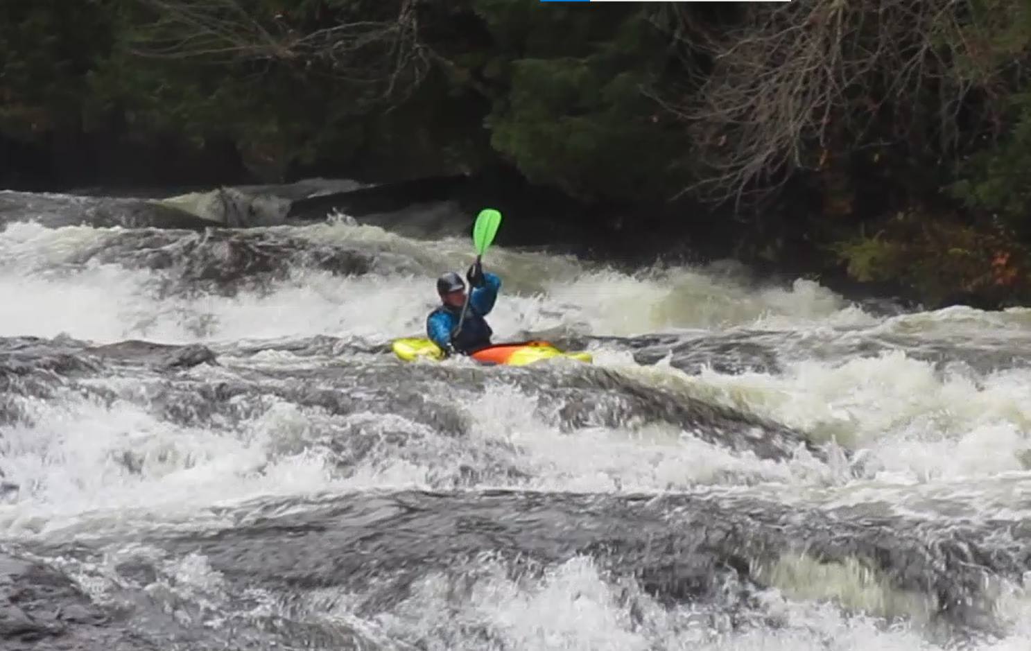 Jamie and I discussed our trepidation about strainers before putting back in below the covered bridge at Greenbank's Hollow, given how prolific the ledge drops with horizon lines are in the steep 2 miles from there to Morse's Mills. Luckily, in this reach there were no trees in bad places. I scouted the waterfall from the right bank (Jamie boat-scouted) and we both cleaned the falls!
I always manage to swim at least once on Joe's, and today I was true to form. It happened in the section between Morse's Mills and the gorge, at the bottom of perhaps the frothiest and most technical drop in this section, a drop that IMO deserves bank-scouting until further notice. Why you ask? Well, here large trees have fallen in from the left bank (above) and right bank (below), the former blocking the preferred entrance and the latter blocking the main outflow. Having missed Jamie's hand signal to eddy out above, I found myself in a tenuous mid-river eddy half-way down this rapid with wood blocking my only egress onto the right bank. From there I signaled Jamie to enter right and drive left. He obliged and in so doing he was able to avoid both strainers altogether (because he's THAT good). I, on the other hand, could not make the same right-to-left move through the torrent of water from my mid-river eddy, and forthwith plowed headlong into the strainer at the bottom, doing my small part to help clear it out (and getting up-ended in the process). My signature strainer mitigation technique proved useful on at least one other occasion in a slow moving section of river, where Jamie opted to lift over on the left. Score now Tony: 2, Strainers: 2.
We habitually walk down to scout the final gorge from the road during the morning shuttle, so we knew this to be devoid of consequential wood. IMO no one should run the gorge without laying eyes on it from the right bank first. Wearing big smiles, below the gorge we agreed it is "big" (and fun) at any flow level.
I try not to let a year go by without getting on Joe's at least once. Three (or four) runs in a year has been a real treat. Joe's wood situation will evolve over time, and those who hanker to spend a day on Joe's just need to be mindful of this fact.
Joe's Brook - Medium
Tuesday Apr 25, 2023
The paddling season for me is incomplete unless/until I've made my way down Joe's Brook from West Danville VT to the Passumpsic River - a 10 mile day-long adventure that's too dry to paddle most of the year. Most years we stop a couple of miles above VT 5 and the Passumpsic, at the 8 mile mark, where a serpentine class IV rapid under a bridge presents a test of skill (and nerve). Ryan M was the only one in our group today who attempted the serpentine rapid, staying so high/so far to the right of hole #3 that his boat eddied out almost all by itself - avoiding completely (big-boy pants) hole #4.
Creek VT says 275-900 cfs on the Sleeper River USGS real-time gauge near St. Johnsbury is good-to-go on Joe's. The 200cfs reading Monday night did not look promising but ½" to ¾" of rain overnight in Caledonia County (according to observers on CoCoRAHS) on the heels of Sunday's soaking rain brought the Sleepers up to 400 cfs overnight... and away we went.
Will Seegers' first-hand report from his "medium-low" run after work on Monday 4/24 also bolstered our optimism that Joe's would be fluid. Lo and behold, it was.
Of course, Jamie would have been happy to see it higher still. He commented by email after the run: "The level was on the low side and fu rocks abounded. The scraping along the ledges decreased the boat weight so carrying them was a little lighter". Personally, I was happy NOT to see it any higher, given that the temperature stayed below 45 degrees all day under cloudy (mostly) but also sometimes sunny sometimes rainy skies, with one sustained hailstorm in the cover bridge section where my fogged-up eyeglasses added to the intrigue approaching the myriad horizon lines there.
Most will agree there are too many long-ish and long class III-IV slides on Joe's Brook to keep count. Our collective memories of "what comes next" served us well, though Ryan K was no help in this regard as it was his first time running Joe's. Judging by the smile he was wearing at the bottom of every big slide, I doubt it will be his last! There was only one swim and one mid-river rescue required (mine) - immediately below the waterfall in the covered bridge section. Having a strong party on Joe's is something I consider to be essential given its 100 ft/mile average gradient and remoteness (by VT standards anyway).
I do sorta marvel at the fact that - up until a couple of years ago - we bombed down Joe's Brook in open canoes. Seems incongruous, but open boaters in the VPC pioneered running Joe's, back in the day.
 There's a cedar tree at the put-in just downstream from the powerhouse on river left and the photo at right shows the level at the end of our run on 4/25. When we put in it was a couple of inches higher - lapping up onto the tree trunk. If the water is any more than 1/2 way up the "J" you best be wearing your "big-boy"/"big-girl" pants as the slides all pick up speed and the holes get stickier/hungrier.
The Wells River, BTW, fell from 1270 cfs to 700 cfs the day before our run, rebounded overnight with the added rainfall to 875 cfs by dawn on Tuesday 4/25, then slowiy dropped to 750 cfs while we were making our way down Joe's. Ryan M has found the Well's River gauge to be another worthwhile indicator when contemplating Joe's.
Joe's Brook - One Perfect Day
Saturday Apr 21, 2007
April 21 seemed early for a scheduled Joe's Brook trip, but the fickle spring weather was decidedly in our favor on this magnificent Saturday. We worried a bit about how many downed trees we would find blocking our route after the April 16th Nor'easter howled through upper New England 5 days before, but thankfully almost all the potential strainers were duck-able. One huge and potentially lethal tree remains lodged near the bottom of the class IV Covered Bridge Rapid, and a portage is (for the time-being) prudent. A carry on either side is feasible. As we've seen in the past on early outings here, occasional thick ice shelves extending from the banks out a few feet and over-hanging the swift current were the more prevalent hazard.
Across Vermont this particular day was so sunny, so warm, so splendidly spring-like, that Ruth Page on VPR actually penned a story about it a few weeks later. It was a huge treat to spend a day like this on Joe's Brook...one of the most naturally lovely and sparsely developed watersheds in all Vermont!
The day started with some mis-communication around the meeting spot. This seems to happen more often than it should, and in this case I take full responsibililty for proceeeding with only 1/2 the group down to the Powerhouse Road put-in before the others had arrived at the West Danville wayside where we agreed to meet. It's always windy and chilly first thing in the morning at the pull-off beside the ice-covered Joe's Pond, while the powerhouse put-in is private, sheltered from the wind, and equally sunny.
We got on the water about 10:30am, and did not finish until ~4:30pm, as Joe's is long and some of it's blind corners and steeper pitches require scouting, especially on the first run of the season. Tina Scharf helped with the shuttle, which was greatly appreciated!
It was Eve's introduction to Joe's, and the playboat she paddles lacked sufficient volume to pop easily out of some of the holes she found herself side-surfing in, including a sticky one half-way down Corkscrew - the opening class IV pitch. Confidence was bolstered when we all hit our landings at Dew Drop Inn, and John showed us the zig-zag sneak route (if you can call it that) through Pinball. Eric and I managed to FLIP the inflatable Shredder when we failed to skirt the monster hole at Great Escape (where a tree trunk partially blocks the entrance), and I am still a bit battered from the epic swim that followed.
Eve paddled extremely well, but shortly after our lunch stop at the covered bridge she decided she'd "had enough" and dragged her boat down a rutted former logging road to the car we spotted at Morse's Mills. I came to the same decision about 10 minutes after Eve, and the two of us towed our vessels trudging through a dense knee-deep spring snowpack where moose tracks were plentiful 20 or 30 minutes out to Morse's Mills. It was exhausting. Meanwhile, Jamie, John, Dan, and Eric were having a super run down through the most continuous and steep section of the river at a really playful medium-high level. Apparently a couple of the holes were grabby, even for those in creek boats, and there was some window-shading to reminisce about while we changed into our dry clothes at the take-out.
Energy levels were sagging and it was past 4pm as the foursome still paddling took out below the bridge at Morse's Mills, but it wasn't very hard to persuade them to get back on the water and finish the trip. We had scouted The Gorge from the right bank during the am car shuttle, so we knew we wouldn't need to stop and scout there. The rest of the drops in this section, 2 of which are III-IV's, were all free of strainers, and we made our way very quickly to the take-out where Eve and Tina were waiting. It was heartening to see Jamie, Dan, Eve, and Eric paddle with such aplomb - all apparently getting better with experience (and age?). As for John, the group never quit praising his boat-handling expertise, his river-reading skill, and his gift for teaching. Having him along on this trip gave everyone else a boost of confidence in class IV waters, and made the trip safer as well.
At medium-high levels Joe's Brook is a 7 course meal for solid class III-IV boaters who are ready for a bonafide class IV experience. On top of which it is spectacular in its beauty and remoteness. With all the talk about small-scale hydro-dam construction to help curtail global warming, it might be time to nominate Joe's Brook for Wild and Scenic River status, to be sure it stays open for recreational uses. Creekers (and others) should think seriously about writing letters to our elected officials in opposition to any such development on gems like Joe's Brook.
Joe's Brook - Why Wipe that Grin off Your Face?
Sunday Aug 3, 2008
I should probably let Tyler or Dave write today's trip report, since it was their first time ever running Joe's. For the most part their ear-to-ear grins summed up the outing. What a great introduction for them to a spectacularly long and continuous stretch of Vermont whitewater!
It took us a little longer than usual to get on the water, but it WAS Sunday morning and equipment DID need to be bleached (didymo abatement) before leaving home. We set a car 10 miles downstream from West Danville at the Brook Hill Rd. takeout and were on the water at noon.
The stick at the pond dam read 5.3 and the bladder was fully deflated and spilling a good deal of WARM Joes' pond water. Add in the 124cfs from the turbines and the sidestream runoff from Saturday's soaking rains and throw in some unforecasted sunshine and you have a rollicking good time...if you can handle it!
Dave and I both got back-surfed then side-surfed by the big munchy hole half-way down the first long rapid below the powerhouse (Corkscrew), and were upside down momentarily. Of course I knew what lay ahead, but for Dave this was a wake-up call that he was going to need to put his game face on and paddle aggressively...which from that point on he did.
The funny thing for me in that first rapid was that I let go of my paddle and watched it float rapidly on downstream, never to be seen again. Or so I thought. For the next 8 miles I paddled with my spare paddle through S-turn (no trees for once), Alka-Seltzer ("plop, plop, fizz, fizz, oh what a relief it is"), Pinball, carried the Big Slide and the Covered Bridge drops with Dave and Ty (on account of lethal strainers in both locations), ran and/or swam the covered bridge section (excluding the Falls Drop) with all of its continuous boogie water, meaty slides, and the occasional worrisome strainer, and ran grinning ear-to-ear almost all the way to the final gorge drop below Morse's Mill before my white paddle came floating past my boat, out of the blue. Hell, it almost jumped right back into my canoe all by itself!
It didn't seem to matter to Ty or Dave that they were paddling playboats, though a creekboat would surely have come in handy where the holes got longer, deeper, and/or wider. On several occasions my open canoe filled basically right up to the gunwales in the first hole or two of a long rapid, and I'd just have to keep on paddling with a "boatful" of water (from whence my email address ;o)
We pulled off the water at 5pm, and were greeted by a friendly state trooper as we loaded our boats. After hearing about our trip, said he lived nearby, and told us he had been thinking about venturing down Joe's Brook sometime in a big truck innertube he owns. We advised against it!
I suppose there must be some way that this could have been a better day of paddling. But right now, I can't think of anything about it that I would change...
PS: As far as levels go, Dave noted back in May that the concrete shelf on the covered bridge abutment (river right) had a little water spilling up onto it. On that day we opted NOT to paddle Joe's due to the high/cold water combo. Today the water was just below that same concrete ledge beneath the covered bridge - and NOT spilling onto it. Maybe we should paint a gauge there...visible from river left?
Joes at Low Water
Saturday Apr 9, 2016
Joes... 10 miles, 1000 feet of vertical. Best whitewater run in VT - Maybe?
I woke up early and called GMP to see what the gauge was reading at the dam and how much they were running through the penstock that morning. The operator said the bladder was 1/3 deflated, the gauge was reading 5.2 and they were at full power generation. That should correlate to a good amount of water in the river bed. We rally 12 folks up there for a 10am put on and are all shocked at how low the water levels are. NUTZ!
Well, we are here, so lets go slide down some lubed up rock. The fact is it was too low, but still fun enough to enjoy the rapids. So 12 of us put in at the power house and got to it. The first 3 or so miles is beautiful with ledges rapids here and there through a cedar swamp. The only strainer that needed portaged is the same one that was there 2 years ago. It's massive and you are best to eddy out on river right.
As things start to pick up we came into the biggest slide on the regularly run stretch. The only option was to run the meat of the current on river right. All that ran it ran it cleanly and we were on our way to Greenbanks Hollow and the beginning of the Miracle Mile section of Joes. Several of us ran the covered bridge rapid, most were clean, some not so much...but no swims. From there it was slide after slide after slide.... Shallow slides, but they went.
Morse Mills section was up next and that was a pretty busy section of water too. Still too shallow to really get the feel for Joes, but fun, with some convoluted rapids to get after.
The only true gorge on the river was the next section of note, it was pretty mellow and clean this day due to the low flows - every one styled it....
Last up was the rapid at the bottom of the run under the green bridge. It was the only rapid of the day that was fluid. It was the only rapid of the day that produced a swim too.
It was a sunny andd fun day on Joes - Everyone ended the run wanting more. Hard to believe a 4 hour run didn't quench everyone's desire for the day.... Next time it will have to be with more water.
Joes including the BFS...
Saturday Apr 18, 2009
Cold Long Fun Day On Joes.
Wood in one rapid below Covered Bridge that is avoidable at low levels. May be an issue at higher water with pushy nature of rapid.
The following was taken from Message Board post...
Russ, Dave, Scott, et al.
Yea the run on Saturday that Russ did with us was more or less LOW boatable. Having been on it at a MEATY HIGH level last summer, I would have to concur with Dave that it is hard to get excited about a run on it at the level we did this past Saturday...that is unless it is the only game in town. (we, myself and a few others, found alternatives to that though on Sunday).
For reference...The bolted on gauge at the top of the dam (you have to look over the edge next to the intake for the aquaduct to the power house - about 10 yards down stream from the covered bridge over the pond outflow) was reading 1.8. The power house was spitting out full capacity/124cfs (which it always does if there is any water going over the spillway or anytime the creek would be runable) so it is really not a factor - it is always spitting that.
At 1.8 two of our group ran the BFS on Saturday. It was absolutely the most rediculious thing I have seen in a while done in a boat. They may as well have tied their boats behind a car and been drug down the road at 3 mph and then off of 3-4 foot ledges. Not an ideal descent of the BFS - I'll post footy of it when I get it converted and editied. May put it in 2x speed for the Benny Hill effect.
The rest of the run was a bumpy ride between the major drops and those were relatively resistant and slow. All holes were punchable sans the beast on river left near the bottom of the Covered Bridge Rapid - At this level there didn't appear to be any clean lines...it went but was not fluid whatsoever. Again boat abusive like the BFS.
The slide above the Covered Bridge went on far left and was a blast...probably a toss up with the last rapid under the takeout bridge for best drop.rapid of the run. The last rapid was twisty and turny with big waves and jets to really give you that roller coaster ride!
Agreeing with Russ, Saturday it was the only game in town sans the Wells (and associated race), so was worth the bang smash run down, but I prefer the Mach 7 with your hair on fire on the slides when it is really lubed up with a good flow. There is something wrong about loosing speed while going down hill which is what it feels like at the level this past Saturday...I guess just a different experience for a different level.
Sorry for the long post - I'll cut and paste this to the TRs as is.
BTW - the Dam opperator said they will be at fully deflated bladder for at least the next couple of days and longer if there is any rain.
Juniper Island Paddle
Saturday Jul 12, 2008
After a last minute cancellation from a third prospective participant, Roger and David met at the Shelburne Bay boat launch a little before 10:30 AM. David was paddling his Wilderness Systems Tempest 170 kayak and Roger was paddling his home made (from kit) wooden / fiberglass kayak. The day was sunny, warm, and the water was extremely calm, with virtually no waves except for the occasional power boat wake. We went up Shelburne Bay, around Shelburne Point, and reached the west end of Juniper Island after about 1.5 hour. We then continued around the island and paddled back. After getting back to the boat launch, we wandered up the La Platte River a ways (very weedy), then went back to the boat launch and ended the trip at about 2 PM. This trip was actually a GMC (Green Mountain Club) trip cross-posted to the VPC.
Kennebec
Thursday Jun 10, 2004
Wow, what a great river! My long-boat friends had been telling me about this for years -- storys about sky-scraping stern squirts, enders with the whole boat out of the water, 8-ft surf waves . . .
Anyway, after walking almost the ENTIRE 5-mile shuttle (although I was at least picked up -- by some blond female raft guides!) I was quite ready to "turn off my mind, relax and float downstream."
It was wonderful. I took off down the gorge with the raft company's "video boater" who needed to get out ahead and stop to take video of the rafts. He was kind enough to show me the gorge. It was the best kind of river-running -- big, harmless and unfamiliar. I think William Nealy, rest his soul, would have described our grins as "illegal!"
This river reminded me how few big-water runs we have in New England. Earlier in the week I had run the Tewkesbury section of the J-C in Quebec, another big-water river. It was nice to be able to take a solid stroke without cracking bottom -- and to be able to fall 8 feet straight down -- off the back of a wave rather than off a waterfall.
The only problem was that I had my stubby little creek boat. Next time I'll bring my slalom boat and get in on those big enders. Or maybe I'll bring my 17-ft sea kayak.
Think about the enders!
Lake Carmi
Sunday Jul 4, 2010
7/4 - We took and evening paddle on Lake Carmi on Independence Day. It proved to be the perfect time. Boat and jet ski traffic had all but subsided and the water was tranquil. We enjoyed a good 3 hour paddle along the State Park area of the lake (south end) that included close-up views of a Bald Eagle, an Osprey, numerous ducks, a raccoon, a beaver, and a dozen or so blue heron. The sunset was dramatic and peaceful. One of those that just leaves you shaking your head in amazement. All the best - Tlove
Lamoille
Saturday May 19, 2007
After organizing shuttle with the assistance of our lovely shuttle bunny, Dawn, we put on around 1pm. The level was low but easily boatable and fun for eddying and small wave play. A few swims were had by some new to the sport, but self/assisted rescues were swift and smooth and recovery was quick.
Smiley's wave was friendly and enjoyed by a few in the group as the rest waited graciously. The run was overall very mellow with play spots throughout. 5 chutes had some good play in the center, although Jim found his own spot in a slot on river right.
We got off the river around 3:30 safe and sound, a good time had by all. Special thanks to Ann Smith for the loaner boat until mine arrives!
Lamoille (Bootleg)
Thursday Jun 10, 2004

Well after a high level around 3000 cfs last week. This week's level seemed pitiful and the trip was almost cancelled. Wednesday my rain danced worked and the heavens opened and provided enough rain to bring the Lamoille up to a runnable level. Although I doubted it would provide enough excitement for some of the more experienced paddlers in our group.
The usual wave at Maura's house was disappointing and just about surfable, but we all had a surf just in case there wasn't anything else...how wrong could we have been. The low water level had diminished the usual rapids to rock fields providing various play opportunities for everyone. A usual sticky stopper which appears on river left provided an ideal opportunity for me to learn the basic techniques for surfing and spinning on stoppers. I didn't want to get off.
By the time we reached five chutes the sun had set. Five chutes never fails to surprise me. At every water level there is something for everyone. Even on this run there were a few nice beginner waves on the left sneak chute and a small hole in the center to keep the experts happy.
All the way down, Cartwheels, stern squirts and bow stalls where being thrown and I am sure there were a few other moves made too.
For a grade 2 river at low water and a bunch of paddlers ranging in experience from grade 3 to 5, everyone came off smiling. A job well done.
Laps on the Gihon
Sunday Jun 4, 2006
You'd think with all of the rain we got on Saturday everything would be pumping high....not such the case. Thankfully the Gihon holds water pretty well and we could score a couple of low boatable laps on it. The first lap consisted of Dave and Bob running every drop like a couple of aces. Will and I passed on the gorge (mustang) consequences still seemed a bit much even at lowish water. All drops went pretty clean though (other than Power House - where one of us managed to spot a brown trout while counting fishies on the way down). We yanked a humungo log out of a smallish drop above Mustang to open up a 2 foot ledge boof move...The second lap Bob and Dave had to take off but we met up with Jim. I am sure the 30ft low head dam for the first drop shook all the jitters of running a new river right out of him. The rest of the run went as smooth as the first drop...that is if you didn't notice all the bumping and scraping we did on the way down. Will chose to run Power House at an even lower level than the previous run...Jim and I walked - just to boney.... All in all it was a good Sunday spent on the Gihon.
Le Taureau / Le Malbaie
Saturday-Sunday Aug 7-8, 2004
This past Friday night Justin and Fred and I drove up to Canada and met up with a whole cast of characters to run Le Taureau, a river I had long heard about, but never "closely examined."
The Taureau ("the bull" in french) is 15 miles long. The rapids build for about 5 miles from flat to class IV, and in the middle 5 miles it is entirely class IV and V. There are supposedly more than 100 rapids, and I believe it. There are supposedly 18 class Vs, and I believe it. Paddlers used to run the Taureau in two days, and I can see why. It took us 5.5 hours and we portaged just twice and scouted only four times.
It was a long day. When we got to the lunch spot halfway through the hard stuff, it already felt like a very long, hard river. The rapids weren't heinous -- no harder (except two) than the West Branch of the Deerfield -- but there were so many of them, so many people in our group (which tends to crowd the eddies) and this river is truly in the middle of nowehere. Add all that up and when we got to the beers at the end in my car, I felt pretty accomplished.
Next day we went to the Malbaie, which featured the most adventurous shuttle of all time and a river that is absolutely in "God's Country," as they say. After the challenging hike in, we were greeted with a warm day and a fun river. It was very relaxed compared to the Taureau -- a good way to wind down. The best part of the trip was a clean 30-foot waterfall. Fred went first and landed flat in the pile of white at the bottom. From the cliffs above we all heard him yell "It's SO SOFT!" So I went ahead and charged off. It was like jumping off my house and yet landing in powder. I swear I didn't even feel it. We even went back for a second run off it.
All in all, it was a great trip. I'll be back to that friendly addiction, that Taureau -- with a smaller group and smaller number of flips!
Lewis Creek
Saturday Apr 18, 2015
The fishermen and women out-numbered the paddlers today on Lewis Creek, but I'm pretty certain the paddlers were having more fun. The three of us put on a good show for them at the series of high, sloping ledges in North Ferrisburgh, where a downed tree in the river-left current at the bottom forced us to go either center or right - scraping some as we went. The hydraulic on river left there at the bottom was looking none too friendly either (but then, it never does). The rapids, aside from the (optional) narrow slot east of the Prindle Corners Covered Bridge (III) and the falls in North Ferrisburgh (IV), are predominantly class I-II. After scouting, we all lifted over the lamprey interdiction dam in the upper section, with ease.
The banks and the woods beyond are for the most part unspoiled, and lovely. We heard peepers, saw some beautiful wood ducks, red tailed hawks, and a big bard owl en route to our take-out at the old RR bridge abutment west of US7. Nick had some trouble above the Quinlans Covered Bridge when he (and Eric) attempted the more technical left side of the island and Nick got tangled up with some tree branches that were blocking the current. It all turned out fine.
The temperatures dropped from the 60's into the 50's after a little squall passed through about the time we put in, but the sun came back out for the last half of the run and it felt super. I know Lewis Creek can be run at lower water levels, but as it was I thought we did our fair share of scraping today - medium low is what I think you'd have to call it. Just under 3 hours, on the water. Nice.
Little River
Friday May 6, 2011
The Little river had been running higher than normal and I had been scouting the infamous weir for the past couple of days. American Whitewater lists it as "unrunnable". However, I was convinced it could be done at this level, 1600 cfs. I posted a couple of pictures on the VPC website showing a tongue on river right that goes around the nasty low head dam portion. Speaking of which, a few more hundred cfs and that nasty dam MIGHT just become a really sweet play hole! That will have to wait for another day, as that didn't look to be the case yet.
Chris and I scouted the weir and decided to give it a go. However, we decided to go up river a bit for a warm up and put in just below the big dam forming the Little River Reservoir. The spill gates were wide open up top resulting in an impressive waterfall over the rocks before hitting the bottom and adding to the high flow in the river. I was first to put in and decided to paddle upstream a bit while Chris was getting ready. I must have been out of sight when Chris put in because he was nowhere to been seen when I floated back down. My guess was that he assumed I went downstream while waiting for him. So, I heading down hoping that was the case. We finally caught back up just above the weir. Not a good start, but we decided to keep on after taking one last look at the weir.
We were both comfortable that the low head dam wouldn't be an issue. The tongue was big and clearly defined. At a normal summer release level, the tongue isn't really there in enough force. But it appeared to be a clean sneak at 1600 cfs. The bigger issue was that there were some nasty hydraulics forming on river right along the gorge walls. The move seemed to be to take the tongue on the right and move to the center immediately after the weir. There were two big waves that had to be punched after this. This was where the real action was going to be, but was beyond the most dangerous parts. After that, it was a big turbulent flush down the gorge.
I had brought my playboat in hopes that there would be some great play wave down river at this level. I was second guessing that decision at this point and would have much rather have had my bigger boat to punch those two waves that were coming up. Too late now. I was the first to go. The tongue got me around the weir just as expected, and I was on line when I crashed the first wave. It knocked me off balance a bit and the second wave came up a just a second or two later. I'd like to say I decided to go for style points and intentionally did a stern squirt, but the truth is that just sort of happened on it's own. I somehow managed to get my bow back down without flipping. I was against the gorge wall at this point and quickly paddled back to the center and on down the rest of the gorge. I caught a glimpse of Chris coming down. He was smart enough to bring a bigger volume boat and made it down clean right behind me.
The rest of the trip was pretty uneventful. The great play wave that I had hoped for, never appeared. Should have taken the big boat. Next time the water is this high, I'll know. Definitely, would do it again. However, the level has to be right. American Whitewater is probably right in that this is unrunnable, or at least shouldn't be run, at normal release levels.
Lookin' for the Flow
Saturday Apr 17, 2010
Lots of precip...mixed up high going into the weekend...
The Mad was up around 1k and the NH was bumping up into the 800cfs so why wouldn't Patterson be at a good level???
So off we went Dave and I met at the Moretown General Store, we met Dan, Ben and Hal in Granville at the take out. HOLY SMOKES it was close to 5 inches low on the gauge rock. Awe what the heck....there was still a channel down through and the major drops were constricted enough to be kind of fun. Well....everything else we'll bang off of rocks. So when we put on I think everyone was freezing. About 200 yards into the run we were all complaining about how hot we were from the constant maneuvering we doing.
We all took turns leading and then getting hung up. The couple of times I was out in front and got hung up - looking back up stream at the beautiful valley we were descending and then each of the friends in our group it sunk in why I boat. All of the guys, even though conditions were less than ideal, were smiling ear to ear. That may have been a grimace on occasion from a good shot to a rock, but for the most part I think everyone was thoroughly enjoying themselves. Patterson has a way of doing that to you though. I've said this before and will probably say it again and again in my reports - This stretch of water transcends a lot of boater ability at a lot of different levels. I have many other favorite rivers that I enjoy boating in VT some that I will drop everything to go run...Patterson isn't one of them, but once I am down in there and really look around at it - I can really immerse myself in the heart of the Greens! It is a magical place, a beautiful place.
We got to the bottom of the run in about 40 minutes and had the rest of the day to go hit up something else. We were already down that way so why not check out Bingo....It can't be any lower than Patterson. I had never been on Bingo as well as 3 others in the group. Off we went south through Hancock and Rochester down to Brandon Gap. Oh boy it was looking low on the drive up Bingo's watershed. Awe what the heck...off we went.
Bingo seems to run very closely to Patterson, Both are of similar size, and steepness. Where they differ is Bingo is loaded with much bigger ledges and slides and has some pretty seriously sculpted geology where Patterson has some bedrock features there is also a good deal of boulder action.
I really enjoyed my first run on Bingo. It could have used about 5 more inches of water but it was fun. The river valley is really pretty but fairly wide open and has much more development than Patterson. It was also ravaged during the 2008 summer floods putting wood in the river in places. Because of the nature of the bedrock some of the lines come into undercut angled fins. I think the group had a good time because they were all smiling on this run as well. It felt like a much longer run and it may have been. We all paid homage to the plastic gods in the Bingo drainage and owe our boats some luv for the abuse they took between the two low water runs.
After Bingo Dan headed home to parental and marital duties. Dave, Ben Hal and I grabbed a bite at one of the best General Stores in VT (Warren) and then went our ways...Ben and Hal back to B-town and Dave and I got in a really nice lap on the Moretown Gorges. It was up around 900cfs...so really pushy compared to what we just spent the afternoon boating.
I have boated the upper gorge years ago but never ventured into the lower and especially at a level approaching 1k cfs. All I can say is what a fun ride. Never hit a single rock, ledge or anything solid! The eddy hopping was fantastic and the larger more powerful nature of the river in there was a thrill. Dave is right - a great place to do laps and really work on your boat control, crossing pushy eddy lines, and there is some pretty nice surf in there too. I'll be back for more!!!!!!
All in all a good Saturday on the water - wish I had snapped some pix.
Lower (not Upper) Mad
Sunday Apr 3, 2011
Although the upper Mad had been run two weeks earlier by several of us (TR above) at a dandy level, we knew the flow today was going to be too low to run the upper Mad as planned. But we had no idea just how low it would be until we launched below the power dam on the lower - a mere 25 cfs ... per paddler! Then within moments if fell further, to under 22 cfs(pp), when Ryan and Dave joined up with our group after paddling down from the Moretown Gorge. I can't recall another time when I've seen 14 boats together on the Mad, the Sugarbush Triathlon notwithstanding. It's always nice to meet a few new folks on a river trip, in this instance including Josh and Tim from Johnson State College.
Speaking of the Triathlon, the reason for our late start (2pm) was to permit club members who volunteered to help with Triathlon river safety to finish their assignments and then drop down for a late-day paddle. Peg was the only one to bow out at the last minute with some lame excuse ("broken wrist"), but she did show up at the "double drop" with a camera to take pictures - redeeming herself!
All but one of the day's swims took place at the Horseshoe, where some underestimated how forcefully the redirected flow at the crux tries to flip your boat upstream. Or, in John's case, I think maybe he was just still too blissed out from the Yanni concert he attended in Montreal on Friday night with Elvia. He swam out of that hole looking as poised and confident as a synchronized swimmer at the summer Olympics - turning down the throwrope that we offered!
It was reasonably warm, 45 degrees, with clear skies, aside from the momentary downpour as we passed beneath the barricaded Lovers' Lane bridge (where a winter's worth of accumulated snow was melting fast in the sun). Although more water would have been welcomed, there was always a line down through every rapid, plus this level boosted the confidence of those new to the lower Mad, like Ken, who paddled super.
At the last drop, where Dave and Ryan carried back up several times as part of a contest to see who could catch the most eddies coming through (4...or 5...depending on who you believe), a snowball fight broke out. Or actually, it was more like a snowball shelling, since most of the targets were in their boats and trying to paddle. The rest of us also were carrying back up here as well, trying various routes, including the far left channel.
Parking adjacent US 2 at the start of Lovers' Lane is much improved since they replaced the old bridge across the Winooski, and will be even better when the new boat/fishing access on the Winooski is completed on river right (later this year??). Overall, it was a quick trip on a nice early April afternoon.
Lower Hudson
Sunday May 2, 2004
The trip was scheduled for the Ammo, but moved to the lower Hudson because of low water in the Ammo. (Except, of course, once the trip was moved, the Ammo came up with snowmelt - but we stayed with the Hudson.) The water was relatively low for this time of year, at 4.0' at the North Creek gauge. When we got to North Creek, we learned it was Hudson River Downriver Derby Day - so we raced to get on the river first, then pulled over a ways downriver to let the racers pass. The wind was remarkably strong, and blowing upriver, to the point that the canoes could hardly made progress in the 2 miles above and below Riparius. In Spruce Mountain rapid, boats were literally being stopped and slipped sideways unexpectedly by gusts, in the middle of class II-III drops. One canoe took out at Riparius because of the wind, and allegedly the paddler hitch-hiked to the takeout with some turkey hunters, if the story is to be believed. The winds did abate before the major rapids below Mill Brook were reached. Other than the wind, there were no problems. We saw the usual collection of birds - osprey, mergansers, mallards, and finished at the Glen Bridge after about 5.5 hours on the river. The wind slowed us up by at least an hour.
Lower Hudson
Sunday May 22, 2005
As of 6PM the night before, there were 8 people signed up for the trip - but, one by one, most came to their senses and backed out, so only three boats actually went on the water. The day was cold, around 50 degrees, and the rain was steady for the time while driving over to New York, although it did stop for most of the on-water time. And, there was no water to speak of in the river, only 3.1' at North Creek. We shortened the trip to be just Riparius to the Glen Bridge, to keep down the abuse to the boats. At this level, most of the trip was just trying to avoid hitting too many rocks on the river bottom, not really whitewater. At the major 'rapids', the goal became to follow the main channel of water as it twisted among the boulders. I think you need to have a level of at least 3.5 - 4.0 feet to have a decent trip.
At the end of the trip, we got an extra surprise, in that the usual takeout on the right (west) shore just below the Glen Bridge was posted and blockaded. We were able to take out about a hundred yards above the bridge on the east shore, where there is a big parking area.
Lower Hudson
Saturday May 27, 2006
This was a group of long-time paddlers heading down the river in semi-matching red MEs, Mad River canoes from 20 years ago. We wanted to put in at North Creek and paddle to the Glen Bridge, but there was some sort of event in North Creek that had the put-in blocked, so we started 2 miles upstream. The total paddle was 14-15 miles, but the river moved along OK, and the wind was mostly down-river, so we did it all in about 4 hours paddling, and another hour mixed in for lunch and various breaks to get our old knees functioning again. The only in-water activity was in a flat-water stretch when we passed a pair of discrete skinny dippers, and quickly thereafter one paddler (to be identified only by the initials LC) fell into the river. He claims he shifted his weight onto a thwart, snapped it, and then the boat flipped!
Other wildlife sighted included a great blue heron, mergansers, and geese with goslings.
The weather was great, with the afternoon becoming quite sunny. The water flow was adequate but non-threatening. A few on the rapids were still class 3, but not hard 3. The biggest challenge was at the 'Hook', where a strong downriver wind prevented careful set-up - we just had to make a mad dash through the s-turn moves as we were pushed downriver.
Like last year, we took out river-left above the bridge, as the traditional take-out across from Wildwaters remained closed.
Lower Hudson
Monday Apr 27, 2009
I tried to have a Lower Hudson trip on Saturday, when it was 80+ degrees, but only Ed Amidon signed up, and I then had late-developing conflict. So, we moved it to Sunday, but still got no additional takers. We decided we would go anyway with just the two of us, since the river was at a relatively benign 3000 cfs. Sunday turned out to be a bit wet and cool, so we decided to move the trip once again, to Monday, since we are both retired, and since Monday was to be yet another 80+ degree day.
We went. It is a lot of driving. Since there were just two boats we decided to keep it to just the section between North Creek and Riparius. The river came up a lot on Sunday and Sunday night, probably from the high-peaks snowmelt from Saturday. The flow was 3900 cfs.
We put on the river at North Creek at 11 AM, and finished at Riparius at 1:20 PM. The day was glorious, with bright sunshine, quite warm air, and only a moderately annoying upstream wind.
Most of the rapids in this portion of the Hudson are caused by ledge systems, often river-wide, and often the best route is to run right down the center, since the ledges can be most eroded there. The water is usually quite turbulent in the center, with crazy diagonal waves, but this often avoids the rocks and pour-overs nearer shore. But, river-center can be intimidating, since the Hudson is a big river, and shore becomes a long way away.
The river was class 1-2 until about an hour into the trip, when we hit a 200 yard long class 3 rapid with 3' chaotic waves in the final drop. All went well with just a little water taken on. The difficulty built in the second hour, with more frequent class 2+ and 3- rapids. Finally, about half-way down Spruce Mountain Rapids, the road bridge came into view - and that meant it was time for the lower half of Spruce Mountain, where the difficulty increased to a solid class 3 with multiple successive ledges. We cheated the first few ledges by finding a route near the right shore, but had to give in and move center for the final ledges. The only real problem was that Ed got a bad leg cramp as he was paddling through the final ledges, but he made it fine.
We were glad to be ending at Riparius. We had commitments back in Vermont later in the day, and we are both realizing that paddling more than a few hours causes real problems to old knees - which unfortunately we both have.
Lower Hudson
Saturday May 16, 2009
This is a long drive to paddle, and the weather looked marginal, but the level looked good - so three of us went. We drove three cars, placed one car at the Glen Bridge, and put in at Riparius. This allowed us to paddle the lower and harder section first, and perhaps quit after this section if the weather got too bad. First we had a moderate head-wind, and then that stopped and a very light rain started off and on. We made the 'hook', or 'Z-drop', with no problems, and then the rain got steadier. We ran the long class 3 with light, constant rain, but got down OK. The level was very enjoyable, but the rain annoying. At the take-out, we once again had to use the left bank above the bridge, which requires a class-3 rock-scramble while carrying a canoe. (Not really - but it is a short climb.)
At that point, the leader (RL) decided that paddling in the rain was not that great. Even though the rain had momentarily stopped, the forecast was for worse weather in the PM. The others wanted to paddle the North Creek to Riparius section, so RL loaded all three boats on his car and shuttled the others to North Creek. Would be no problem, their cars were at Riparius. RL left, and after 10 minutes thought "I never saw LC get his paddles from my car" - checked - and there the paddles were. So, back to North Creek to give LC the paddles. The two remaining boats headed down, and the weather started getting nasty. A strong headwind came up and blew the boats around in Spruce Mountain Rapid, and lightning was approaching as the boats got to Riparius. Shortly after the boats were loaded on the cars, the proverbial situation of "all hell broke loose" occurred. The trip home was described as class 4 driving, with cars pulling off the road in driving rain. About the time the boats came off the river, back at North Creek the gauge started going straight up because of rising water. But, everyone got off the river in time to beat the driving rain and the rising water - so it was a good trip! Len and Frank really know how to squeeze every moment of excitement out of a day!
Lower Hudson (NY)
Sunday May 18, 2003
Organizer: Richard (the Magnificent) Larsen
Difficulty: intermediate WW
Level: medium
Author: Richard Larsen
This was a trip organized in short order because of expected great weather and water level - and all turned out to be true. It was a beautiful cloudless day, with a high in the mid-70s, and with the North Creek Gauge at 4.9 feet. All in all, it was a perfect Class 3 trip. We put in at North Creek at about 10:30AM, and paddled to the Glen Bridge, taking out around 3:30PM. We saw a fox walking along the shore, and Common Mergansers and Canada Geese on the river. The rapids were pushy, but none were overwhelming. We had lunch at the Riparius Bridge, which was under construction, so the area was somewhat disrupted. The Creemee stand at the train station was, however, open, so some were able to enhance the river food with another of the major food groups. What more could one want from a whitewater trip? We had good rapids, warm temperature, clear sky, and Creemees.
Lower Lamoille
Wednesday Apr 24, 2002
Organizer: Richard Larsen
Difficulty: intermediate WW
Level: medium low
Author: Richard the Magnificent
This was the first of the Wednesday evening trips that actually happened in 2002. The temperature this evening was in the 50s, and the river lower than normal at this time of year. We put in just above Two-Island Rapid, and floated thru the first rapids without incident. We didn't see much in the way of birds, just some Mallards - no ospreys this time. The only problem was the sun angle, which was directly in people's eyes most of the trip. We arrived at the 5-Chutes area fairly quickly, so most of the boats played around in the current, and a few tested the water temperature and their swimming strokes - but no real problems. The total time on the river was about 2 hours. The sun was just setting as we finished, and the air cooling rapidly.
Lower Lamoille
Sunday Apr 11, 2004
We shuttled cars with the assistance of Frank Wells, who was on call and could not paddle. We put in below the dam at Fairfax, and had a 2.5 hour paddle down to the normal takeout between the bridges. The weather was a mixture of sun and clouds, and seasonably cool, with temperatures in the high 40s. The water flow of 1600cfs was low to the normal of 2400 cfs on the date. It was a pleasant early-season paddle, with a lot of mergansers on the river.
Lower Lamoille
Wednesday Apr 21, 2004
This was the first of the Wednesday post-work trips for 2004 on the Lower Lamoille, hosted by Rich Larsen and Ray Ingram. The river had dropped below its average for the date (2400cfs vs 3100cfs), but still had decent flow. The day was warmer than expected, about 60 at the start time, but dropping into the 50s as the sun went behind clouds. The wind was at our back for the whole trip, odd for the Lower Lamoille, so we floated down the river quickly, with extra time for playing at 5 chutes. Some paddlers practiced rolling - some practiced swimming - but there were no problems. The usual river dwellers - Ospreys and Mergansers - were evident in the lower portions of the river..
Lower Lamoille
Sunday Apr 17, 2005
The trip planned for April 16 was moved to the 17th, because the river was at 9000 cfs on the 16th. The 9000 cfs level is runnable for open boats, but the potential swims can be long, so we waited a day for the level to drop. We put in just below the Fairfax dam (which is an impressive sight at 4000 cfs) and paddled to the takeout between the bridges below Five Chutes. We ran into Weed and Zilic in Two-Island Rapid, and our group paddled down with them. No drama, no swimmers, just a good float down the river.
Lower Lamoille
Saturday Apr 8, 2006
We cancelled the trip as an 'official' trip, since there were only two boats, and the leader thought ACA required three boats. The trip was held as 'unofficial'. We paddled from just below the dam at Fairfax Falls to the takeout on the north shore of the river, just east of the road bridge and west of the railroad bridge. The day quite cold, so we moved right along, only spending 1:30 actually on the river. (The weatherman said it was 40 degrees in Burlington, but there were big icicles hanging from roots on the banks where shaded from the sun - and they were not melting.) The water level was delightful, with a nice mixture of waves and rocks at Two Island Rapid, and all five chutes well defined at the rapid of that name. We saw the usual Lower Lamoille wildlife - Osprey, Mergansers, and Mallards - but no other paddlers on the river. Everyone else must have been staying warm!
Lower Lamoille
Sunday Apr 1, 2007
We had a paddling day that is as good as it gets on April 1 in Vermont. The temperature was in the mid-50s, with sun early, but clouds moving in. Water flow was almost exactly at the median for the date. The icebergs and churning brown water of a few days previous had disappeared. We put in below the dam at Fairfax, and spent about 2 hours 45 minutes on the river. The first part was floating and leisurely paddling, and then we had the decent but non-threating run through the rapids. Some did some surfing, a few practiced their rolls, and one swam a short way, but we had no real problems. We saw mergansers, geese, and other assorted waterfowl. The biggest obstacle was at the end, where we had to negotiate a Vermont version of the Khumbu icefall. The river had tiled the shores with 6-8' high ice from ice-out, and we had to work our way over the slippery walls to get up to our cars.
Lower Lamoille
Sunday Apr 6, 2008
The river gods decided to smile on us this day, and everything was just about perfect. The day was sunny, and relatively warm, up into the 50s. The water level was 'just right' for a novice / intermediate trip, at 3100 cfs, right near the average flow for this date. The power company (or someone else) had significantly improved the access on the north side below the Fairfax dam, such that even passenger cars could cruise down to river level. We met at the take out, consolidated cars, and headed to the put-in for a start at 1 PM. We had a nice float through the flatter sections, with no substantial headwind. We had a least one first-time-on-a-river boater, but with Dan Beideck helping him out he did fine. No one swam, which was good, given that the water was extremely cold. At the main rapids, we ran into a couple of other VPC folks, including James Raboin, who paddled a ways down the river with us. After a short stop at the island, a few folks heading down quickly to get in some time on 'Smiley', which had a well-formed hydraulic. We continued down through five chutes, and were off the river about 3:45.
The trip did provide a study in paddling demographics. Without getting into detailed numbers, it is safe to say that the average age of the open boaters was 'substantially greater' than that of the kayakers - very substantially - and that each open boater was probably older than any of the kayakers. As we know, there are indications that the open-boat community is going the way of the dinosaurs!
Lower Lamoille
Saturday Apr 11, 2009
The weather could have been a few degrees warmer, the river could have had another 1000 cfs of flow - but it was still a fine trip on the Lower Lamoille. The flow was 2000 cfs, which is good for most of the year, but this was statistically one of the dates of highest flow - 3000 cfs - so we had hoped for more. And, the high temperature was mid-forties, when statistical average high should have been low 50s. So, I am whining about the water level and the weather, but I have to remember that we surely have done it in much worse conditions.
We met below the dam at Fairfax Falls at noon, and unloaded the boats and gear. The little road at this put-in has been greatly improved over a few years ago. We were able to leave almost all the cars at the take-out near the lake, and got back to the dam and onto the river about 1:15 PM. From the beginning, the wind was quite strong, and upstream, like it always is. The open boats especially had to work hard to go downstream, even with the current. In a number of flat areas, we had to stay right against the south shore, under the tree branches, to break the wind - but unfortunately it kept us out of whatever warmth the sun offered. Once we got to the main rapids, we did have some boaters in the water from playing the waves, but no real problems. The level was easy. About this time, one of the paddlers who had flipped earlier in the day became very cold (leaking dry-suit), and we had to use most of the extra wool clothes we had to allow the paddler to warm up again. We had the extra gear on the trip, so there was no real danger, but it could have been a significant problem were there no available extra warm clothes. Hopefully the situation served as a reminder to all.
A few of the boats stopped for a short snack at the islands, while some of the others headed down to play in 'Smiley'. Soon, we all continued down the river, with just a few boats making a short stop at 5-Chutes. With all the headwind, and the cool temperatures, we were later than we had expected to be reaching the takeout, and all were ready to call it a day.
Lower Lamoille
Saturday Apr 10, 2010
We delayed the put-in until early afternnon, and that worked out very well. The morning had been cold, but the sun came out around 11 AM, and by 1 PM the sky was totally clear. Of course, when the sky clears this quickly, it means that a front is moving through, and that usually means wind - which is always an upstream wind on the Lower Lamoille.
The water was low for mid-April - 1800 cfs versus a normal of 3000 cfs, but this is well above the minimum boatable of about 1000 cfs.
This was also the first day of trout season, so the two main problems on the river were 1) fighting through the wind and 2) not running into fishing lines. The rapids themselves were reasonably mellow.
We had two canoes and two kayaks. We met just below the dam at Fairfax Falls, unloaded all the gear, and drove to the take-out at 12:30 PM to leave a few cars. We were able to start down the river just after 1 PM. As planned, the trip down to the top of Arrowhead Mountain Lake took 3 hours. We didn't play much, because the canoes were delayed so much by the wind. At the upstream end of long flat sections there were whitecaps and waves rolling upstream, and sometimes the canoes could make reasonable progress only by paddling right along the shore, where the overhanging tree limbs reduced the wind.
We rested our old knees by getting out of the boats at an island below the first rapids, and were surprised to see a weasel-critter playing along the opposite bank, swimming into the river and getting snacks. We debated among river otter, weasel, or mink, and settled on weasel - but looking at the Vermont Critters website it probably was a mink. There was another one down near the takeout. The only other notable wildlife was the usual collection of merganzers.
Lower Lamoille
Wednesday Jun 8, 2011
As usual, this early June trip on the Lamoille was planned months ago knowing that the flow might be very low by late spring. And low it was, but this spring one could say that was somewhat surprising! Fortunately for denizens of the Lake Champlain shoreline we have been getting less rain and more sun and warmth over the past 10 days. This Wednesday the air temperature was about 90, and the water temperature was in the mid-60s.
A few days after VPC's Novice Clinic, it was a good opportunity for some participants to get more practice-a preview of the Class II Clinic in July. Doug, Rod, and Justin all made the trip. It lacked challenge for Justin, who is an advanced novice with the beginnings of a combat roll, but it was perfect for Doug and Rod. The rest of us got relief from the heat and some late day relaxation. The weather turned ominous about two-thirds of the way down the river, as the first signs of impending thunderstorms arrived-thickening cloud cover and a strong west wind. We made it to the takeout before anything more happened. As it turned out, the storms didn't hit northwest Vermont until much later, but most of us weren't inclined to press our luck. (Besides, I was hoping to make an 8:30 pm performance at the Flynn. It didn't quite work out that way.)
All in all, it was a very pleasant way to spend a muggy workday evening before nightfall.
Lower Lamoille
Sunday Apr 1, 2012
Is this an April Fools joke? Golly Gee, Where's the water? Not in the Huntington and not in the Lamoille (so much). Yes, some plastic was left behind, but still a great first run of the season for half of the group. I think over half of us had rescue life vests but they were not called into service. No swims, no rolls (other than practice), though Rod felt it was necessary to check the water temperature at the end.. It was low water at about 1050 with scrapping and rock bracing. Smiley disappeared, however there were still a few places that you could stick a nose into and have more then a little fun. Especially river left at five chutes. The pickings were slim. But it did not rain, the company was fabulous, and hey, we were on the water.
Lower Lamoille
Sunday May 6, 2012
The trip was scheduled for the Lower Hudson, but there was confusion about Saturday vs Sunday - and little interest in driving to the Hudson - so we moved it to the Lower Lamoille for Sunday May 6. None of the open boaters had been on the river this year, so we all had to find our gear and hope we did not forget anything. We had minor problems - one guy's car rolled down his hill before he was in it, and had to get a tow truck before coming to the river. Another person, who will not be named, managed to show up with his wife's wetsuit, his wife being 8" shorter and 80 pounds lighter. (Was able to get it on to about mid-butt, but there was a lot of neoprene binding in some positions.)
So, the preparation was more exciting than the river. The flow was acceptable for late May, but pretty low for May 6. The temperature was pleasant, and we had a good float down the river - except for the wind gusting upstream. The long flat sections were hard on the open boats, with their higher profiles, and we sometimes found ourselves heading upstream in a gust. We got to the rapids, negotiated them without problems, stopped for lunch, and got to the takeout between the bridges after about 2.5 hours on the river.
Lower Mad
Saturday May 4, 2002
Made it through the first little drops on this beautiful afternoon, warm sunny, water at 500cfs.
We made it to the double drop with the "gotcha rock" at the bottom. All scouted, set up the throw bags and let Scott take the lead. Rolling up as you feel that "gotcha rock" getting closer, is tough. No damage just wet. My turn next. Eddy out after the first drop, perfect, eddy out after the second, perfect, I am done! Not quite, the final ferry over the "gotcha rock" got me. No damage. Next came the "new to the sport" crowd. All dry and clean all the way through. Scott immediately started mentioning his karma for the day, I mentioned that HE should go first next!
Needless to say we all swam later,(except for didn't dump Floyd) probably a total of a dozen or more between the whole team. You do not learn if you do not fall (tip over). All had the right gear and the right attitude, plus plenty of throw bags!
One of the memorable moments was watching bomb proof Prior pull off a roll x 2 mid stream as well as watching her go off Horse Shoe Falls. She is still working on mastering a new paddling technique specifically for drops and the like. Ask her about it if you see her on the river!
One thing we all learned is sunglasses, specifically wet sunglasses in the shade, do not improve your paddling.
Live and learn.
We did a little "green up" at the end. Wouldn't it be nice if we could all give a little back to this wonderland that we paddle by?
We all had a great time, running time 3 plus hours.
lower mad
Friday Mar 27, 2009
It was a nice evening, for Jamie and Ryan this was their second run of the year and for Chris and I ( Paul ) the season openner. We all practiced catching eddies as we went down.We got to horseshoe scouted,Jamie showed us the way with a clean run taking the center line right just skimming the whirlpool and boofing over horseshoe for a clean landing in his playboat. That being said I followed up with a clean run of my own in my creeker. Ryan also cleaned it as well. Chris was alittle more conserative and decided to walk around. However the story gets better! I ( Paul ) was feeling cocky and decided to hit washing machine center right hitting that big wave dead on!!! That turned out to be the wrong move, flipping my boat but also missing my roll. Consequently swimming to the next corner watching the guys rescueing my boat. The lesson to be learned is to do what is safe and do the sure thing!! Getting cocky isn't the right choice!!! Anyway we all had fun. Paul
Lower Mad
Wednesday May 13, 2009
It was a great turnout. We all stayed together picking are way from eddy to eddy. I had three first timers Francis, Dave, Pat which after scouting horseshoe chose the middle line. All made clean runs good job guys! Tony had his canoe and made it look easy. The rest of the group followed the grace. However Ryan and I thought we would go for the right side and I'll let the pics to follow tell the rest of the story!! I want to thank everyone for coming. It was a pleasure as always. Paul S.
Lower Mad
Saturday Apr 9, 2011
We substituted the lower Mad for the Huntington when it became clear that the Huntington would not have enough water in it. We stepped up the class level based on who was signing up. The level was great starting at 543 CFS and ending at 627cfs, with loads of sunshine.
It was the first time on a river this year for about half the group. And, it turned out that we had three people who had not been on the lower Mad yet (is that possible?). Yeah, we ferried a bit at the put in to see how many cobwebs there were (maybe more than a few). The first rapid went very smoothly with no issues. Double drop could also be called double trouble. Two rolls and a swim. It was reported the water is cold. The next class II stretch was great, as everyone took their time surfing and ferrying. Horseshoe had no takers but five of us did the left chute. Dan looked like he was about to do the horseshoe (unwillingly) but managed a few power strokes that got him to the left chute. Then he aced the rest of it. Dave graciously showed us why it is important NOT to point your bow river right (towards the horseshoe) when dropping over. It ended well, but those visuals will stay with us for awhile.
I had the opportunity to practice (successfully) my offside roll in washing machine. No one else deigned join me. We boat scouted the last drop which went great for all but one. We had spent over two hours on the water and noone was up much for playing anymore.
Another fantastic day on the water with an excellent group. Thanks.
Lower Mad
Saturday Apr 30, 2011
Everyone but Woody (who we didn't know was coming) met at the Lover's Lane take out at 11 AM and headed up in two cars. At the put in we found Woody's front wheels mired in the ditch (looked solid, but wasn't), but John had a towing strap and managed to pull him out. We warmed up ferrying back and forth at the put in, and then started down, with Jim in the lead and Chris running sweep. John flipped and swam near the bottom of the entry rapid and lost hold of his boat and paddle. David grabbed the paddle and clipped it to his tether, but then ended up misaligned on Double Drop and ran through the big curling wave on the right, and flipped and swam (but held on to his boat and both paddles). Meanwhile Jim was chasing John's boat and managed to bring it to shore below the bridge. After watching all this, Francis decided to walk around Double Drop. On one of the next rapids David managed to flip again, but this time pulled off a successful roll. We all got out above Horseshoe, and only John decided to try running it. With four throw ropes at the ready, John bumped along the far left and was in almost perfect position as he took the drop. It looked like he took the drop well, but didn't have quite enough speed, and disappeared into the froth. Both Jim and EJ threw ropes, and John, his boat, and his paddle were all pulled to shore. John said he didn't have to wet exit, as the turbulence sucked him right out of his boat. Francis decided to walk Washing Machine as well as Horseshoe, but the rest of us proceeded through it. John took a swim crossing the eddy line out into the turbulent pool below horseshoe, but managed to get out before being flushed through Washing Machine, and EJ rounded up his boat at the bottom. I didn't see it, but since I saw him draining his boat on the shore, I think Woody also swam in Washing Machine. Somewhere along the way the strap holding EJ's seat back managed to come loose. She had the pin that linked the back strap to the ratchet strip, but the back to it was missing. A jury rigged repair with an old piece of duck tape wrapped and tied around it held for the rest of the trip. From there on down the trip was pretty uneventful. We all took the right side of the island for the final rapid, and John went back up and ran the left side as well. Then a flat water paddle with a stiff headwind back to the take out, getting there a little before 2, I think.
Lower Mad
Saturday Mar 24, 2012
This was planned as a Upper Mad paddle but low water conditions caused us to change and paddle the Lower section below the Moretown Dam. At double drop or S turn rapid John decided to try and side surf the first drop. Getting out of that drop was easier than getting in but a little change in edge solved the problem and a quick roll was needed.
We spent a fair amount of time trying to catch every eddie and every wave possible as we headed for Horseshoe. Jamie first no problem , John decided to get hung up on a small rock at the edge of the drop proceeded to try and paddle up into the eddie with out success and then decided to run the drop stern first(I have to make this interesting for my fellow paddlers or it would not be as much fun) . Another quick roll all was well. Both Chris and Ken made it look easy. John had to run it again to show everyone that bow first is the perfered way. Jamie decided to give the right side a go.His approach was off a little and the not so forgiving flow decided to flip him and try to hold him down. Jamie was succesful getting upright even though the pushy water and ledge tried to keep him down.
The rest of the way was more surfing and catching eddies. Ken was happy that he ran a clean run, Chris was happy that his elbow was not causing him problems, John was happy not to have any more unintensional rolls and and Jamie is just happy to be out playing. thanks for the fun trip and I know we will be back on the Mad many more times this season. John
Lower Mad
Sunday Apr 9, 2017
This trip was scheduled for the Upper Mad, and trip reports from years past have us on the Upper Mad at flows as low as 750 cfs, though 1100 cfs is more of a medium level for the Warren to Waitsfield stretch. Not to be deterred, the Lower Mad is a nice consolation prize when the Upper Mad is off the table.
We let the day warm up, meeting at noon for a ~3 hour paddle - out long enough to get a sunburned nose if you (like me) forgot about sunscreen. When the day dawns below 20 degrees it is easy to forget the sun on April 9th is as hot and high overhead as it is on Labor Day.
The level dipped below 700 cfs ever so briefly before turning upward again with melting snows higher up, and the mercury in Middlesex had reached 60 degrees by the time we took out.
There were too few women on the trip - zero in fact - but otherwise it was an upbeat and handsome bunch. No one ran Horseshoe river-right, but the throw bags saw some action anyway, there and further down as well. In all, a very pleasurable knock-the-cobwebs-off season opener.
Lower Mad (open for business)!
Tuesday Mar 10, 2020
As the day began, the Mad R. USGS real-time online gauge was showing "ice", but the New Haven gauge was barely over 500 cfs, so we were surprised to find the Mad with, as Jamie put it: "a lot more water than I was expecting". The put-in trail was still snow-covered, but the river was open from top to bottom, and fun! We had sunshine and rain showers - sometimes simultaneously - during our run, and temps close to 50 degrees. Quite pleasant for March 10th. Chris had to pull his skirt and swim below the horseshoe (river left), after capsizing above the lip, but he was unfazed. The water where he is going later this month (Costa Rica) will be warmer, if he happens to have another swim!
Lower Mad 4/18/2007
Wednesday Apr 18, 2007
Sweet run. Level was higher than we estimated when we put on, but a great time was had by all. Gauge was at about 1500 when we checked it after the run. Everyone walked Horseshoe, though a bunch of us gave it a good look. Eve, back from AK, had a clean run. Tyler, the new guy from Baltimore, came to play and should be a great addition to the VT boating scene. Woody and Kirk, solid as always. One swimmer, not mentioning any names, but a safe and quick rescue and we were on our way again. Washing machine was BEEFY but tons of fun. RT 100B wave was washed out, and Bottom Drop was pretty much one wave. But, we had a great time, its a fun, clean level and everyone left happy, wet, and satisfied.
Lower Mad Call in Sick run
Tuesday Oct 26, 2010
WHAT A RUSH!! Five of us bit the bullet and left work early, to come paddling. It started out with Jim P, Rich R and myself, and then grew with some quick text messages to Noah and Jon. Gathering at the Lower Mad take out, we spent some time discussing wardrobe. I told the boys they were "jibberjabbering" (a term stolen from Jim F) and we should move on. We put in at bout 4:15 and were off and running. Jim P made sure he had a tight leash on me as we started our run. After some ferrying, eddying and deep breathing, we made it down the first shoot into the double drop. A quick scout of the area, left me portaging and the boys running the shoot. (I just didn't want to show them up). Under the bridge we went, after a minor 4 kayak pileup. Jim had drawn a clear line for me to follow, which of course I did not. I chose my own eddy approximately 50 feet further down. After an incredible save off my back deck (ok pure luck), we hit the flatwater. (where was John A when we needed him, the flatwater King). We continued down this way until we reached Horseshoe, where Rich and I were given the very important task of holding rescue ropes (ok we portaged around it but we DID have ropes in our hands). Rich and I walked for what seemed like 5 miles and put in under Washing Machine. after getting back in our boats, Noah and I were in a neck and neck race for this little set of rapids, playing a quick game of chicken. He won and I ended up beached on the wrong side of some rocks. Again, I walked for miles, (well maybe 75 feet) until Jon came to get me (thanks Jon). Back in the water we were, heading for the second bridge, when Jon decided this would be a good time to get a fish count. Well he must have greased his boat prior to put in because that little bugger would not wait for him and took off down the river, with Jim chasing it. A few tries and giggles later, Jon was on his way. After ramming Rich under the bridge we eddied in to look for the ledge. Well, they did...I kept on going and found myself balanced precariously on top of the ledge, with no choice but to go down. After some expletives, the rest of the crew made it down and enjoyed a good chuckle at my white knuckle paddling. In the eddy we discussed the last feature of the Mad before the Winooski. Jim told me what to do and where to go, and he told me to follow him down. Now did I? NO! That rather large rock he told me to go AROUND...well I went right into it. With a loud crack that left my teeth rattling, we punched through the rest of the holes and high fives were shared all around. AHHH! The sweet taste of victory. Paddling back to the take out, discussions were had all around about this being the last trip of the season.....well....maybe....ok, the last trip of the day seemed more realistic. Crawling up some goat path, we made it to the cars and headed home full of plans for the next trip down the Mad. Thanks guys, I had such a great time and could not have done it without you!
Lower Mad River
Sunday May 19, 2002
Organizer: Fritz Senftleber
Difficulty: intermediate WW
Level: medium
Author: Fritz "Over Again" Senftleber
This whole paddling thing is in the attitude. When you dump ,more times than you can count, you need a good attitude.
New boat, nice people, almost to much water and away we went. Ira showed up last minute and asked for a tag along and ride back, no problem. After his first roll, we all felt a little better. Later we were not sure if he wasn't aiming for the rocks though. It was the verical pin that he shifted through and recoverd that made us all realize, he has attitude. Ray I was up to his flawless paddling tricks, The best part with ray is the ear to ear grin, and his willing ness to share some of those tricks, all attitude. John W, tried to keep up with my dump record, not quite! Nice endo! Great attitude!
We all had a ball. Warm, fun and if you haven't been able to tell loads of good attitudes on the Lower Mad.
Thanks for putting up with me!
Lower Mad River
Wednesday May 11, 2011
Ah, Spring. The weather starts to get warm; the trees start to bud out. Wait a second! That sounds like the end of paddling season!!! This was the refrain of about a dozen boaters aound noon on Wednesday, May 11. And it was motivation to get them all on the Mad River - all at the same time!
And thus started Spring's Last Hurrah 2011.
The VPC posting was set: meet at the takeout at 5:30. Then someone posts a "warm up" run at 3:30. Amazing to me how many paddlers don't work for a living!
Six hearty souls (John, Ken, Francis, Jamie, Rich and Jim) met at the takeout for an early run. It did not take too long to get ready and consolidate boats on a couple of cars. The level was low but boatable. All the rapids had enough juice to get through. We moved down river slowly but steadily. We did have to be at the takeout by 5:30! There was a quick scout at Horseshoe and those that chose to run styled it. (all on the left channel) There was a quick swim at Washing Machine but that did not stop the group for long. We paddled the last couple of rapids, joined up with the Winooski and made it to the takeout with time to spare. (OK, maybe 5 minutes)
Waiting at the takeout were a few more paddlers. Actually, it was A LOT more paddlers. We figured out a way to not have to run an intermediate shuttle to get the two cars from the first run back to the takeout. We just loaded everyone up and headed to the put in! Thanks Dan for the pickup truck that can hold ten or fifteen boats! Or so it seemed...
Once at the put in we meet up with a couple of more paddlers and found it hard to find a parking spot. Were we paddling on the Mad River or skiing a power day at Mad River??? Hard to tell by the number of cars.
So here's the math: 6 paddlers on the first run. Minus 1 for the second run (Francis). Plus 8 paddlers for the second run equals 13! But wait there's more! Another private trip picked the unfortunate time to put on at the same time. Plus 3 more boaters. We were a flotilla of 16 paddlers in 15 boats! Yowza, that's a lot of plastic on a small river like the Mad! As trip leader I needed to keep counting heads. No small feat as the group bobbed down river.
But we managed. We poked our way down the river and spread out so that we didn't get in each other's way. We congregated at the larger eddies so we could count heads and recount stories.
At Horseshoe almost the whole group ran the left channel. Each run was clean! (nice job all!) Paul popped into Tony's open boat as an understudy to Emily (Paul - do you like the theatre reference?!?) and the two went over the drop to everyone's cheers and whistles! Sweet run!
Then the real action began. A number of folks walked back up to give the right side of Horseshoe a go. I would like to say that every run was as clean as the left, but sadly that wasn't the case. First an orange play boat could not escape the froth. Then a certain green Fluid kayak hit the right slot a bit off line and went deep. Both events causing some rope throwing practice. Nice rescues guys!
From there we poked down to the last rapid - including another quick swim at Washing Machine. A few people took multiple runs on the final rapid as the sun set and darkness started to settle in. We arrived at the put in at 8:15 with still a bit of daylight to spare.
Packing all the drivers (and there were plenty) into a couple of rigs for the ride to the put in was challenging but not insurmountable for this adventurous bunch. Once everyone was reunited with their cars and equipment we said our goodbyes and headed home with smiles on our faces.
Now we are all looking to the skies for signs of clouds and rain. It's amazing how quickly we forget one of the wettest springs in recent history and are once again dusting off our best rain dances to get our favorite rivers to pop just once more before the heat of summer really kicks in!
SYOTR
jimp
Lower Mad River
Wednesday May 9, 2018
Ten of us gathered on a warm (80 degrees) spring day. This was the "Team Edition" trip. We had the following "teams":
Team Centrifuge: JimF & Max (they were fun to watch flopping all over the place)
J-Team: JimP & John
Eddy Hop Team: Hugh & Steve
Team Chris: ChrisW & ChrisM
Father / Daughter Team: Paul & Rita
And we will not make mention of any swim team members...
Since it was so sunny and warm we took our time getting through the first few rapids. Yes, there is still wood in the S-Turn rapid but we all missed it. We burned so much daylight by the time we hit the Route 100 bridge we needed to hustle a bit to get to the take out by sunset. We made it with a few minutes of daylight left. By the time we took out the temps were still in the mid 60's!
Everyone has a great time. Why can't all days of paddling in Vermont be 80 degrees with enough juice to get us downriver?!?
jimp
Lower Mad Run
Wednesday May 22, 2013
Fun 'after work' trip. Water was a decent level. Lots of play to be had. No incidence to report .There was a large tree sitting on the rock in the center of the river at Horseshoe. Ryan decided to try to do the right thing by removing it, which then put it in the cauldron below the right side of horseshoe, recirculating. This made it abundantly clear that hole is at least 20 feet deep. Eventually, after many tries to remove it from there, the angry tree revolted and tried to pull Ryan in. Eventually he was able to get it out and put it up on the left shore. Otherwise, fun, uneventful trip!
Lower Mad, early spring run
Sunday Mar 11, 2012
The weekend was looking pleasant, albeit with slightly subfreezing temperatures on Saturday, but a high above 50 possible on Sunday (at least in Burlington). An exchange started on the message board, and a plan for a 1:30 pm Sunday meeting at the VRC takeout was settled on.
As it turned out, only Jamie and Chris showed up. (John Atherton had hoped to participate, but Sunday was a no-go for him.)
It was a nice medium flow, and the river was completely free of ice, with just a few slabs perched high on ledge outcroppings near the final drop (from last week's spike over 1,000 cfs). The snow on the banks is patchy at this point, even in the shade-indicative of the lack of snow this winter. We ran the left side of Horseshoe without a scout. All drops are free of wood.
The climb up the bank at the new VRC takeout is mostly free of ice, except for a patch located at a bad spot where the trail steepens just before it attains level ground. Chris spent at least a minute traversing this treacherous little stretch in order to prevent a fall. A bit of work with a small sledgehammer or a garden spade could remove this hazard (hint, hint).
With highs in Burlington pushing 60 for the entire upcoming week, and rain in the forecast, one can say that the paddling season is officially underway in northern Vermont!
Lower Moose River, VT
Saturday Oct 13, 2007
Dave Coyne and I ran the lower moose (East St. Johnsbury- Passumpsic river) at a level of 6 feet on the Victory gauge. The run is about 4 miles, the run starts off with a bang with a big wave train under the first (car bridge) with good surf. Right around the bend is the biggest drop on this section, so scout carefully on river left right after the first bridge. There is a sneak line to the left side of train bridge pillar, but it's a little scrappy at 6'. The main line has a monster hole dead center that spans 80-90% of the river, not a place I would really like to be. Dave says it's a bit more tame at around 5 ft, (min suggested). The line of choice at this level was to start off in the eddy just above the bridge and boof the far left side and skirt the big hole directly under the bridge. The move was intimidating, but luckily no one got munched today.
After the railroad bridge there is about 2 miles of quick class I water until you hit the next section. The next rapid is a series of 3 ledges all about 3-4 feet high. Once you get to the ledges the run picks up and the rapids are close together.
Right around the next bend the river runs directly into the Maple Grove Farm factory and makes a definitive S-turn under another bridge. Once you get behind Maple Grove there is a fun class III, that consists of a big bouncy wave train, run right down the middle, watch for wood on the left side. From there to the next significant drop is pretty straight forward class II+.
Once you go under Rt. 2 again the river makes a definitive sharp left turn. Be careful here. The next drop is a big rocky ledge about 8 feet tall, the biggest single drop on the river. Stay left and scout. A cliff that juts out blocks your vision and if you miss the eddy right behind the rock you are committed to the drop. There is a simple line far left side if you follow the green tongue of water along the left bank. After this there are 2 more little ledges before you hit the confluence of the Passumpsic.
This is a really fun section, I think I would prefer it to the upper section from Victory down. Overall I would rate this as a class II-IV run to be in agreement with the guide book. Once you get down by the mills, past Maple Grove, there was unfortunately a lot of dumping that had been done and the river banks are riddled with tires and metal pieces.
The river runs directly along Rt. 2 the entire way so there's lots of opportunity for road scouting. To get to the take out take Concord Ave. across the bridge. Make a left onto Elm St and park back near the baseball fields. To get to the put in take Rt. 2 east for about 4 miles until you see a gravel pull off just past East St. Johnsubury on the right side of the road. If you want to skip the first big drop and the quick water section you can park and put in at Petty Co. Junction off of Rt. 2.
Lower New Haven
Saturday Apr 5, 2008
Though the water was low(ish) the boaters were willing. As usual, the start is an attention getter. The cold water face splashes give better adrenaline than coffee. After boat scouting for wood on the second rapid (there was none) we continued on to where the New Haven meets Baldwin Creek. Just above the first bridge one of the kayakers developed a split on the bottom of his boat. Though an on river repair was effected he ended pulling out. Duct tape really doesn't keep out the water too well. Things continued uneventfully as we all made it under the second iron bridge just above the mill. After road scouting, Anya lead Tony down in the tandem very smoothly. All boaters made it down with a smile. Gwen and Anya were having a great day but got caught up in conversation and found their boat full of water just above the last rapid. They said the water wasn't too cold. After getting their boat back to shore they continued on smiling, if not a bit cooler. All in all, a very good time.
Lower New Haven
Wednesday Apr 13, 2011
It's not often you can tell the exact flow of the New Haven but the gauge was flat at 1000 cfs for 5 hours Wed evening. When we met at the put-in John discovered that he had forgotten his PFD. Francis came to paddle but was feeling uncomfortable with his roll and decided not to so he loaned his PFD to John. In the first rapid John flipped and swam because his paddle had snapped in half. Noah and I retrieved his boat around the corner and luckily Dan had a breakdown paddle so we were able to continue. We had a fun paddle down to the iron bridge where Francis met us. Unfortunately, John's boat got away from him and Dan and I chased it through the iron bridge rapid and caught up a little way down. We had a great time down the last section and had an easy shuttle back thanks to Francis's help.
Lower New Haven
Wednesday Apr 20, 2011
I woke up Wednesday morning to a significant thunder and lightning show. The downpour outside my window and New Haven level of 450 on my computer screen led me to believe that we may actually get to run this flashy section of river. Even more amazing is that we predicted this would happen - this trip was put on the events calendar two months ago!
Thus started Gauge Watch 2011.
Through the morning as the gauge went from 450 through 745 and onto 1,140 I was pretty stoked that we would have decent water.
By noon when it was 2,320 I was thinking "Whoa Nelly"!
When it crested at 2,660 at 1:30 I was crest fallen (nice pun eh?). I had never run this stretch at anything above 1,100 and was not sure I wanted to bite off more than double the volume.
Then the strangest thing happened. The level started dropping. And dropping fast! By mid afternoon it was dropping at a rate of more than 200cfs per hour.
By 4:30 it was down to 2,050 and by our put in time at 5:30 the level was at 1,860. This trip was a go!
The only thing I can think of is the rain came down so fast this morning that it did not have time to soak into the ground. It went straight to the river and drained off fast. I have not seen the New Haven drop this much in past water events. It usually has a more gradual decline after peaking.
Only Jamie had run at this level and that was a bunch of years ago. His recollection was that the lines are the same, just the water is bigger and faster.
And that is exactly as it was. All the traditional lines were the same. It's just things moved more quickly and if you got off line, the holes that were there to munch you were that much bigger. As an added bonus, new lines opened up on most of the rapids allowing for choices not available at lower levels.
The only minor bit of excitement came when Paul hit "the meat" and got flipped in the hole in the third rapid (the one after Baldwin Creek comes in). That woke us all up as the water is cold and none of us wanted to be upside down - even if for only a few seconds like Paul. Game on boys!
Even the normally slack middle section moved along and there were a few larger holes to dodge.
We took multiple lines through the bridge rapid to the delight of a local watching from the bridge.
At the island we took the left most slot - which I had never run before - since it had a good amount of water.
There were multiple lines through the next set of rapids and we explored most of them. Then, at the take out bridge, I ran the right of center line. Note to self - at these levels if you run the right of center line you will not be able to make the take out at the bridge! The river is just moving too fast at that point. I meandered downstream and took in the last bit of rapids. Paul, not wanting me to have all this fun by myself joined in. We then walked our boats back up to the waiting cars and compadres. The take out was full of smiles and excitement of the run just had. It was like running a new river for the first time.
At these flows it's a quick run. We did the whole thing in an hour and that includes a few minutes scouting the bridge rapid. The next time the New Haven goes big (did someone say 3,000?!?) look for me to post a trip on the Lower. It's a hoot!
JimP
Lower New Haven
Wednesday May 9, 2012
Who'd a thunk? Planning a lower New Haven trip for early May that actually went? The water was at a lowish level but definitely runnable. The last rapid above the take out bridge was fairly fluid and the rock dodging wasn't as bad as I expected it would be. (A half dozen people were on the ledges as well.) Our group of seven had an interesting mix of experience both in boating in general, and on the lower New Haven specifically. Which, as it turned out was good.
After the entrance rapid we took a hard left through a tight wood pile to stay in the flow rather then walk to the confluence with Baldwin Creek. Rich R got caught, by the downed tree root on RR, but managed a tasty hand roll out from under. Unfortunately, his paddle remained under the log. With two safety people, Rich was able to retrieve the paddle but not with out some difficulties. That corner can be tricky.
All but Chris and Eric opted for the center line on the South St bridge rapid. Which went well for all of us. Chris styled his line down the RR side really nicely.
There were three swims by some of the old timers (though, I don't think anyone is under 50 in the group, Jim?). One swim was above the South St bridge at the end of the rapid leading to it, one was at the entrance to the South St Bridge rapid and the last was on the last hole at the take out bridge (UGH!). It turns out that rocks can hurt just as much as names, if not more. Jim P was the lead navigator for a couple of the less experienced and did a great job showing the lines to avoid rocks and holes (mostly).
The trip took us about 2 to 2 1/2 hours of river time (including scouting the South St Bridge rapid and boat retrieval) and we finished shortly before it started to rain again and get dark. A good bunch of people on a fun river, at an okay level. That's good.
Lower New Haven
Wednesday Apr 15, 2015
We were gifted with a bluebird day with temps in the 60's. After a lull in water mid morning, the level rebounded nicely to a fluffy medium. Prior to consulting the 'Rock of Gauge', experts place the level at or around 800-1200 cfs.
8 craft took to the water at 5:30 pm, made up of the open boat stylings of Tony Shaw, Eric atop an IK and 6 random kayakers. The energy was good for the first rapid, preceding the mandatory portage/wormy dog shuffle to avoid the log jam above the confluence with Baldwin Cr. Sidenote: anyone with free time between runs on Saturday is urged to bring a chainsaw and work out any extra energy on that pile(one channel will do).
The river provided plenty of fluff through the boulder strewn run and our group held good lines, including at the rapid with no name above the new bridge. Line choice was varied, the water level gave us options seldom seen. Center tongue was popular choice, with Chris's door #2, no, door #1 line providing the most excitement.
The paddle, approximately 2 hours of smiles and laughter, ended with a takeout situation that was hard to beat. I'll not mention the size of Max's carbon footprint. If further information is desired about the takeout , just let me know and I'll meet you at the putin.
See we you on the water,
Jody
Lower New Haven: we have water!
Saturday Oct 19, 2019
The week ending October 19 brought north central Vermont a lot of water. The New Haven watershed apparently received 2-3 inches of rain, and at about 3:30 pm on Thursday (the 17th) the New Haven crested well over flood stage on the USGS gauge, at a reported flow of 9,900 cfs. I was curious to see what that flow might have done to the riverbed up in Bristol.
I touched base with Paul Bicknell on Saturday morning, and we agreed to meet at the church (the put-in) at 12:00 pm. It was to be Paul's first time down the LNH, and the water level and weather were perfect for it — a crisp, clear October day. (It was also ideal because Paul now lives in Bridport, and can get to Bristol in less than 35 minutes.) I posted on the message board, and Chris Frost saw the post and met us in Bristol.
After Paul and Chris set shuttle we put on about 12:30. The second rapid after the put-in is now a straight shot down to the Baldwin Creek confluence. Some large boulders that used to be under the log pile that we have previously passed on the left have apparently been moved downstream, close to the end of the rapid, before the river turns left to head into the next drop. Such changes were already somewhat evident in prior runs this year, but Thursday's blowout flow enhanced the transformation.
Various other sections from there down to the island rapid (next to the Lathrop lumber yard) seem to have changed in subtle ways. At the island rapid itself, we took the middle channel, even though the flow on the gauge at that point was below 700 cfs. It turned out to be quite fluid. I recommended that choice out of concern about possible wood in the right channel. We eddied out at the bottom of the middle channel and walked across the big island to look at the right channel, and found it completely open. However the bottom of it appeared quite different from what I remembered, and looked difficult to get through at that flow. At higher flows I suspect that staying left all the way through (doing less of an S turn) will be the best line.
The remainder of our run went cleanly, despite the low flow through a section strewn with large boulders, which tends to be the most demanding part of the run.
I drove up to Eagle Park after we were done and checked the Gilbert gauge. It was reading about 1.0 feet. I'm guessing it was at 1.2 when we put on.
While I was at Eagle Park a guy named Eric (from up near Johnson) showed up to do a solo run, with shuttle help by Will Parini. He examined the upstream corner of the fishing platform from his boat before heading downstream and saw signs of damage. The river had clearly come over the platform on Thursday, and there was quite a bit of debris on the upstream and downstream sides, with fresh sawdust on the platform itself. Apparently some logs had been cut and removed in the past two days. A Bristol resident who was instrumental in bringing about the construction of the platform in 2012 was also there when I arrived. He was there to assess any damage that might have occurred during the flood.
The New Haven watershed is primed for a rapid rise and sustained flow with subsequent rainfall this fall. That is what we are getting as I write this (Sunday, October 27) for which 0.75 inches have been forecast. Let's get on it!
Lower Paul Stream - Episiode III
Saturday Nov 6, 2010
So this day was lined up to be eventful before the clock even struck midnight. I got a call from mark telling me that the East Branch of the Nulhegan was ripping. That's all I needed to hear... I quickly got on the horn and rounded up some kayakers to be raft-bait and we all met the next morning at 10am boater time, so 11am for the rest of the world. To our dismay the EB Nully had dropped over 2 feet overnight. We'll keep that in mind in the future, she's a flashy giant. So, the runs are now up for debate: a quickie on the true Nully, or over to Paul Stream. Well, Mark was stuck with a bunch of creek-boaters, and we wanted to get on Paul's at a respectable flow. Mark was down, and off we went.
We were pleased to find the run had about another 8" of water at the takeout than our previous spring descents, and pleasantly surprised to find the flow in the rapids to be sublime. We all walked Seam's Easy, the first drop at the put-in bridge. That Seam didn't seem so easy today... Triple drop, or Puma Pounder, or Mamba Muncher - whichever name it ends up being - housed a large flat recycle on the last drop today, and the photos of Mark's side surf show just how fun it was. There aren't any photos of Jamie's insta-backender and subsequent trashing. I guess Ryan grabbed the rope instead of documenting the carnage. Either way, a quick throw bag got the swimmer out. The sneak line was in on far river right today and provided a class II-III sneak to the hole.
So, gear in hand we're back on the river. Headed downstream and enjoying the flow, we come to the next drop, which was a large curler/hole. No problem, but those pesky rocks in the outflow provided the second swim of the day - nice form Ryan! Boat rescued, javelined paddle recovered, we're off once again through the mellower section before the river tilts downhill and picks up steam. We all did a quick scout of the first section to check for wood, and didn't find any. So from there we were off - picking through the boulder gardens and numerous micro eddies. Ryan and I led around the corner and waited. And waited. And waited. Ryan was already downstream checking the lines on the meat of the rapid, a little doozy called Log Jam. I headed upstream just in time to see a rope go out and a swimmer come down. Mark had pinned his raft on the shallow rocks and tossed Cynthia overboard to free up some draft. No, just kidding - I don't know how she ended up in the river, but Gerard was the hero with the throw-bag to get her to shore. Mark swam it in with official "VPC Safety Coordinator" style, and got ready to hightail it back to the truck to warm up Cynthia and avoid any complications.
So now we're there - 4 kayaks and an empty raft. What to do with the raft?
A) Ghost float it and hope it doesn't pin.
B) Line it and hope we're all still friends at the bottom of the rapid
C) Leave the damn thing there and get it when the water drops
D) Hop in and hold on
Well, being the smart kids we are, Jamie and I chose D and hopped in the raft after Gerard and Ryan had some ropes ready to go near some rather large holes. We get in, asking "who wants oars, who wants the paddle?" and "Have you ever been in a raft before?" Well, I grabbed oars, Jamie grabbed the paddle, and neither of us had ever paddled a raft, let alone in a creek. Turns out that beast will go where it wants and keep going. We were completely off line, almost falling out at the top of the rapid, then off line for the second part, hitting the big hole we didn't want to hit (which in hindsight wasn't so bad, the raft slipped right through). And to finish it off we were sort of on-line at the end (see Ryan's Photos) but lost an oar that got sucked right out of the oar-lock. We got the oar back after eddying up a few hundred feet downstream. So much for the first time in a raft!
After that ordeal, Ryan and Gerard decided to take the Class VI sneak line on a 50 degree bank, and Jamie and I, once again being smart, decided to run the rapid rather than carry. It looked fun, and the portage actually looked harder than paddling. Off we went. The entrance was smooth - a sweet boof over a medium sized hole. Then down the slide, missing the big hole halfway down, and around the pillow at the bottom. Eddying up to high fives, huzzahs and general class IV excitement. An excellent rapid, approached in multiple craft, on an excellent creek.
The remainder of the run has one more nice drop, then some mellow action to the take-out, where Mark met us just in time to lug his raft out of the river.
All was well, and this is surely one of my favorite local runs.
Pics: http://www.vtpaddlers.net/talk/upload/index.php?directive=show&showVolume=rivers&showAlbum=Paul+Stream&dirAlbum=Paul Stream&showEvent=11_6_2010&eventLabel=11%2F6%2F2010&datestamp=2010-11-06 00:00:00&index=0&date_test=%3C%3D%272010-12-31%27#slideshow
Video: http://www.youtube.com/watch?v=qd17lg7zJR4
Lower White River
Saturday Mar 30, 2013
Running at a lower-than-normal ~900 cfs for most of the preceding week, the USGS online gauge at West Hartford dissuaded our group from attempting to run the (planned) "Upper White" from Stockbridge to Bethel. In hindsight, when the gauge suddenly popped up over 1400 cfs on Saturday morning, we probably would have made it down The Upper...
Spring - that is to say, March - 2013 proved to be much better suited to sugaring than boating. But today it was about as nice a March day as you could want for a get-out-the-cobwebs class I-II river trip. We waited 'til noon to meet, to let the day to warm up some, and put-in close to 1:30 (once a loaner PFD for yours truly had been procured). Thanks to Mark and co. for making that happen!
The 2.5 mile stretch to West Hartford was bathed in sunshine with a moderate, steady tailwind. The ravages of tropical storm Irene are still evident in many places along the banks, but not much in the riverbed itself. This is in contrast to the upper White, where many parts of the riverbed AND its banks bear no resemblance whatsoever to pre-8/28/2011.
We played to our hearts' content at the 8 or 10 low ledges that make the Lower White popular throughout the summer months, and no one got into any trouble. We stopped on a sandy beach to stretch our legs at one point and eat hors d'oeuvres (thanks, Heidi). At the take-out Mark shared his wife's macaroons with us all. I would paddle again with this bunch, any time! Paddling time: 2:45. Daytime high: 51 degrees.
LowerMad River
Wednesday Apr 30, 2014
It was a cold rainy evening but the old( age that is) faithful's showed up and ran probably the least exciting trip I have ever been on. No swims and no rolls. Even Horseshoe did not have it's way with anyone. Though we did not have much excitement it was great fun being with friends and fellow paddlers. At the take out nobody hung around for the traditional brew. People did talk about getting home in front of a fire and relaxing with one. This is the end of the April spring paddling season but we have the rest of the year to play and paddle with old friends and new friends to make. I am very enthused about paddling and what VPC is doing in the State with Resent release on the Green and up coming on Sheldon falls this weekend. Keep it up Ryan and Bob(Aw rep) Thanks
Mach 7 With Your Hair On Fire - Hancock Brook (NBW)
Friday Oct 15, 2010
Ever been shot out of a cannon or at least felt like it? From the moment my bow hit the water to the premature end of the run, I am pretty sure I had a Concorde jet engine attached to the stern of my kayak. That should set the stage for this TR....
It was noon on Friday, almost a mirror of the Friday 2 weeks prior. Stuff took it's time to pop but when it did, everything was too damn big. Believe it or not the NBW was too friggin' big again!!!!! Having a good hook on the local beta (living 10 minutes from the NBW and its tribs) I had a couple of options up my sleeve. When Dave rolled in from scouting the upper part of the NBW he said he wasn't comfortable with the level and I definitely wasn't just looking at the last drop and knowing what the flow there translated to on the bigger, more convoluted ones upstream. The decision was easy; let's check out a rarely run tributary to the NBW. Fortunately Dave and I had done some woodworking on said drainage at one point with Chris Weed a few years prior and the wood situation was much better than you would expect. Ben and Russ were all for checking out the roadside romp and had heard of the infamous teacup gorge at the bottom.
Off we headed to Hancock Brook.... We parked and scouted the meaty sections with the majority of the vertical drops near the bottom. I knew from first look I was out for any of these. The undercut slide looked like death and the usually calm pool above the teacups had a concave hole in it of about 3 feet and was actually looking more like the inside of a toilet bowl than a pool with a whirlpool forming....forget about it! So we headed upriver to scout along as we went. Above the vertical drops the river looked much more manageable but still balls to the wall!. I was really impressed with how fast the water looked to be moving. Everything looked clean up to what was thought would be a decent put-in except for a small log just downstream. We dislodged it and the current swept it away downstream to who knows where; man that floated away really fast!!! When we got back up to the vehicles we decided to drive up further. The run looked too good not to keep checking up to the last major culvert before it becomes a true mountain brook coming off of Mt. Worcester. Right below this culvert there was a pretty good sized log jam that we all thought putting in below would be the best move. IF we were to run from this spot to just above the waterfall section it would be close to a 2 mile run. Not bad and at the speed the river was moving it may take 30 minutes if all went well.
Speaking for myself, as I was gearing up my stomach was in my throat. Ben, Dave, and Russ were pretty calm compared to how I was feeling. Dave was first in the water and ferried to the other side of the river into one of only about 3 eddies on the entire river that was big enough for 4 boats. Did I mention there were barely any eddies and most were 1 boat in size? Instantly we had to make a decision of which way to go at an island. I led the right side and we all bopped down a-ways to where we knew there was a limbo log and a right hand turn in the river that was the start of the first real rapid. It was a long class 4 and relatively steep with holes and waves all over. The ironic thing is it really wasn't much different than what we had just boated through. Dave led, and Russ followed with Ben and me in sweep. As I rounded the corner and ducked the birch tree I saw Russ stopped river right — stopped in a hole and surfing like mad to get out. Ben eddied out river left and I met Dave below in a slightly larger eddy. As soon as I peeled in I heard Ben's whistle and saw the boat. Russ was out of his boat and it was on its way to us. Dave and I quickly jumped out of our boats and grabbed the Jefe and pulled it ashore. Russ was out of the river and his paddle was pinned on river left. Russ was okay but a bit winded and eyes like saucers. We reacquainted him with his gear and we scouted the next drop that had a decent eddy behind it and then the flush on under Hancock Brook Road.
From this point things eased up a bit and I caught the eddy behind abandoned bridge abutments, where we initially thought we would put in. It was a good place to regroup and get the team on the same page. Just below here is where we had dislodged the river-wide strainer and let it take off. I knew we had one significant rapid and then a 5 foot high sloping ledge that quite possibly had a retentive hole at the bottom. As Ben and I peeled out and headed downriver Dave and Russ followed. We passed the place where we let the log go and then you could see the horizon line for the rapid. Definitely a class 4/4+ with a center to left move over two distinct drops both forming broken holes. Ben did a good job of navigating them so I followed his line to some success on the first part and basically just throwing two huge back-to-back boof strokes on the second part to bridge the two holes. Little did I know Dave was more or less under my stern on the first drop and was off line to the right in the first part of this rapid. He stopped in the first hole and never made it out of the second hole so he was getting recirculated in the top part of this drop with two substantial holes below him. He came out of his boat to be pulled back into the hole now having an "out of boat experience"....his first ever. I caught an eddy and saw the boat go by me, then the paddle. Russ got the paddle out of the river but the boat was headed to the ledge drop below. Dave was out of the river and safe on shore — road side. I had been sitting in the eddy assessing what was next and if I should chase the boat down. As I peeled out Ben and Russ were screaming that I need to eddy out. Just as I was headed into the eddy where they were Russ pulled out and I missed my move. I was just going to run the drop and deal with it when Ben bellowed that I needed to eddy out above the drop...Not much of an eddy but I jetted my bow up on a shallow bench, launched my paddle on shore and jumped out of my boat about a foot from the lip. At that moment something red caught my eye; Dave's boat was vertically pinned below the drop in the main channel on the exact log that we had dislodged earlier. At this point Dave, Russ, and Ben were on river left and I was on river right — good thing because I could wade the river right channel and get a line on the boat from the island. The boat didn't have any water in it and was light. Stupid me; I got the line on the boat and to the guys on shore. No big deal — I can just lift it up and out. Sure enough the log cut loose and I almost was caught up in it, the boat, and the rope. It had snagged my leg on its release; I got lucky and the log took off. They reeled Dave's boat in and realized it had split on the stern again. Dave's day was over, leaving him with all of his gear and another weld job. Ben and I decided to pull the plug on the run and I headed downriver to a small bridge to join up with the guys.
We gathered up the vehicles, Dave headed home, and Ben, Russ and I met up with some UVM Kayak Club members to run Martin's. In hindsight we could have paddled downriver a good bit in more or less class III/IV boogie but we had made a decision and called it a day on Hancock with our parts intact in spite of a couple of severe beat-downs on a full-on steep creek. We'll be back for more of what Hancock dishes out!
Mad above Warren
Saturday Apr 11, 2015
We were in the mood for some exploring and that is what we did. Neither of us had been on the Upper Warren section of the Mad and so we decided to try it. Our information was that it would be good to go between 700 and 1,100 cfs. It turns out the our run was done with the Moretown gauge running between 800 and 900 cfs. Italos turns out we both thought that was too low by probably a couple hundred cfs. Rivers change. We scrapped an awful lot and pushed off the bottom a couple of times too. We drove south on 100 and when the river was looking too closed in with snow we pulled over and dropped off the boats roadside so we could set shuttle. We continued driving south looking for a place to turn around. Within 100 yards we came to picnic area pull off. Okay, so we weren’t felling particularly bright about that. We dropped a car at an old Bobbin Mill where the Lincoln Brook joins the Mad. The run was about 3 miles total. After dropping the car at we went back to the boats a few easy drops downstream of the parking area. We didn’t try to catch the first two drops as one was snow capped and the other wood choked. While not exactly a theme for the day we did end up carrying maybe six times due to snow / ice ledges / wood. Not too bad. The first drop should have been relatively straight forward but it was NOT. I got caught in an ice shelve. Though remaining upright the whole time, it was very unpleasant and a more than a little unnerving. Fortunately, I’m a “trainable” and I learned my lesson well. Justin found out how slightly undercut rocks are hard to lean into. It wasn’t a good start for either of us. Throughout the ride we found lots of slightly undercut rocks (and tons of ice shelves that we avoided). The rest of the trip was mostly II maybe a couple of easy III’s. Warren Falls was definitely not going to be run due to an ice bridge right at neck level just beyond the lip. There may have been t a couple of III’s that we had to walk around due to snow or wood. The only thing we saw of consequence was Warren Falls. So, not much of an adrenaline rush (other than the opening drop). But the woods and rocks / ledges we were around were definitely worth it, at the least for one round. And there were some interesting houses (huge) that we passed that were definitely not your McMansion.
Mad after work....
Wednesday May 5, 2010
Your run of the mill night on the Mad. Frigging spectacular evening to be on the water.
The group played out the river pretty hard. The first rapid everyone caught as many eddys as possible - It may have taken 30 minutes to get through elevator shaft. Everything else was fun down to Z-rapid where a few hit multiple eddys on both sides of the rapid and in both steps. John even caught a great mid rapid eddy! The 100b surf wave was surfed up and then it was off to Horseshoe. Everyone who ran it ran it cleanly and all wend down the center avoiding the munch right side.
Washing machine caused some minor problems but most folks eddy hopped their way down it.
THe lower gorge was clean and the last rapid I think every one hiked up for a second shot at it.
Most folks left tired with grins on their faces. Dave, Gerard, Paul and myself stuck around for a speed lap (only catching the "fun eddys") We pulled out in the dark after our race lap and were off for home.
What a great evening to be on water!!!!!!!
pix posted
Mad River
Wednesday May 16, 2007
Nine hardy souls came out to run the Mad on a cool and rainy night. The river Gods blessed us with about 2 inches of rain in the past 36 hours. I estimate the river was around 800cfs when we put on and about 1300 when we took out.
We had something old (big long old school boat), something new (cute little play boats), something borrowed (an old school play boat) and something blue (again, the long boat).
There were a few mishaps along the way. The number of boaters made rescue and equipment pickup a quick process and we continued our progress downstream.
One scary moment occurred near the last rapid when one of our group was upside down for quite some time. A hand of god was needed to get him upright and it took a minute for him to come to his senses. (I spoke with him the morning after via e-mail and he is OK) It reminded everyone in the group the need for safety and alertness on the river.
Of note: there is a big tree at horseshoe. It does not interfere with the run but makes scouting a bit tricky. There is also a tree hanging down on the right wall in the next rapid after horseshoe (one I call alleyway and I have heard others call washing machine). It is avoidable and even if you hit it you just end up with small branches scraping along your helmet.
JimP
Mad River
Wednesday May 4, 2016
Two sure signs of spring: 1. fisherpersons are now on the river and play boats are starting to make an appearance after a long winter's nap.
And so it was as we met on the lower Mad river on a cool and cloudy day in early May. No sun to be had and temps lingered around 50.
We had some rain just as we were changing into our paddling gear, making sure that our "dry" clothes were really not that dry. And then it rained again right as we took off so we needed to change into our semi-dry clothes, again in the rain. Of course it did not rain while we were on the river and there was not enough rain to give us a juicier ride.
Once on the river we meandered downstream stopping for an occasional play wave or interesting eddy. But in general at this level, there is not much going on other than dodging rocks.
Everyone had a great time (measured in smiles) and stories were told in the flat water sections. There were no interesting events at Horseshoe with clean lines all around.
There was one swim at the last rapid (Old Schoolers like me call it Commotion) but we quickly recovered from that and moved on to the takeout.
The takeout proved to be the most difficult thing we did all day. In good weather the Winooski takeout is difficult. Throw in a receding river that exposes some nice mud and a bit of rain to make it even more slick and you've got yourself some fun. There were grunts and groans and some contortionist moves to get out of still floating boats. And that was just me! But no one ended up in the drink so I am claiming success!
Bottom line, a good group of folks running a familiar river in early May at low water. Nothing to complain about here!
jimp
Magalloway R. (ME)
Friday-Sunday Jul 5-7, 2002
This second annual funfest featured affable friends, appetizing fare, and aquatic
frenzy. Diane joined Sam to keep him company and to chronicle the trip as our
personal bankside photographer. The overnighters gathered Friday evening at Sam's
(a remote College Grant cabin north of Errol), where Diane kept the rest of us
entertained through dinner and beyond sharing her passion for wildlife biology...and
birding in particular. Sam and Randy found common interests in forestry...and woodworking
in particular. Georgia, Faith and Tony just seemed happy to be out of the fast
lane, however briefly. Sam Brungot (longtime Dartmouth College Grant Caretaker
and namesake for the cabin we rented) would have enjoyed this night of woodsy
conversation in the quiet surroundings he so loved.
The chemistry through dinner and Saturday evening - with Sam and Diane back in
Vermont - was decidedly more unabashed and would have most likely had ol' Sam
blanching. Everyone pitched in with meal preparation and clean-up, leaving time
for exploration on nature trails nearby on bicycle and even a hike up the Diamond
Peaks.
Oh did I mention we paddled? Well we paddled...hard! Never mind that drought conditions
prevailed across New England. The Azisocohos Lake dam release provided spring-like
water levels both days. The play-friendly 900 cfs level inspired many surfers
and even some side/back surfing at the final rapids' big hole on river right.
Tony misguidedly tried to run the big class IV put-in drop on the far right on
the last run Sunday, and learned the hard way it is every bit as turbulent as
it appears from the shore.
Call me if you are interested in joining us for a repeat, July 2003, when the Grant cabin is again reserved and the water will be swiftly flowing (802-879-1655).
Magalloway Weekend (ME)
Friday-Monday Aug 29-Sep 1, 2003
An eclectic group of boaters and outdoorspeople met up north for a Labor Day Weekend of hiking, biking, flatwater, and whitewater boating. In addition to the Magalloway class III participants listed above, we also enjoyed the company of Faith Knapp, Lucille and Dick Allen, Becki Bates, and Lynn McDermott, who opted in turn for novice whitewater stretches of the Androscoggin River around Errol, eagle and loon watching on Lake Umbagog, and a leisurely Upper Connecticut River trip en route back to Vermont on Monday.
For the first time the VPC maxed out the cabin capacity at the private and secluded Johnson Brook cabin. 10 of us enjoyed a roaring fire in the woodstove, a starry night, a filling meal, and some old fashioned northwoods revelry. Evening guests waxed eloquent on subjects like what can happen when you DON'T let your teenagers jump off of bridges, and what can happen when you DO let your parakeet fall into the mayonaise jar. Becki treated us to a heaping dose of corny humor ("Really...you saw a fox driving in? What was he driving???"). Dick brought along his copy of the Hoagland essay "Walking the Dead Diamond River", which embraces a conservation ethic for these private mixed-use woods. Those who slept on the screen porch and those in the Aziscoos Campground in Wilson Mills were greeted with near freezing temperatures Sunday Morning, though it warmed to near 70 each day and didn't rain. Some heard coyotes yipping in the night, but none observed any big game during the weekend. Still, signs of moose and deer were abundant.
Eric B. and Tony detoured on Friday through South Danville VT to dismember several deadfalls obstructing Joe's Brook with Eric's chainsaw, in anticipation of a Joe's run this fall if weather permits (or next spring for certain). The rest of the Friday group arrived after dark, and some were less than impressed with the patchwork of divergent College Grant logging roads, the printed Dartmouth Outing Club directions, and the accompanying map. Can you say "SUCK"???
By daylight, at least, everyone seemed to enjoy their elected outdoor activities: Saturday, Sunday, and even Monday. Bob and Marvie returned to paddle the Errol section of the Androscoggin, where they got their first whitewater instruction about 20 years ago. Eric B. rode west by bicycle on Sunday for 50 miles or so before his motor transport (a.k.a. Andy Meilleur) caught up to him. And Tony completed his 'Around Vermont in 30 Rivers' odyssey on a scratchy class I Connecticut River float from Colebrook to Bloomfield with Becki and Lynn.
Most assuredly there is something for everybody during the VPC Magalloway weekend. Hope you can fit it into your schedule in 2004!
Maine
Friday-Sunday Aug 13-15, 2004
This past weekend I followed the rain to Maine and ran some good rivers. On Friday I ran Walker Brook in Mass. -- a really cool class III-IV creek that some friends told me about. It was cool except for biking the shuttle at the end. I'm no Lance Armstrong. Five miles on a mtn bike with flat tires was terrible. But I was about to find out that shuttles in southern NE are nothing compared to shuttles in Maine.
I drove up on Friday to Maine and ran Sandy Stream, a class IV gem with more 5-foot ledge drops than I can remember. This is my friend's local river, so we flew down it -- but not before darkness set in and I ran the last mile "on verbal directions" . . .
My friend Chris is like The Godfather of Maine Paddling -- everyone knows him and pretty much does everything short of calling him "Godfather." He knows all the rivers like an expert, and with the water flowing on Saturday, we set off from his house towards the good stuff.
We met up with Brad and headed to the East Piscataquis. I didnt really know Brad "from Adam," but I had seen him clean the challenging "Tunnel Vision" a few weeks back, and so we all set off on the East Pis with confidence. The highlight was a huge drop appropriately called "Big Balls Falls." It was truly a leap of faith. Just below we ran one of the gnarliest drops I have ever seen. Later that day we rolled over to Cold Stream and put on for what we thought would be a quick 4 mile run.
Wrong. When we took off, we found that our shuttle driver was nowhere to be seen. To be brief: we had no shuttle and were in the middle of nowhere on logging roads. We ended up stumbling 5 miles through the dark, enlisting several locals for the rescue mission, and finally finding our shuttle driver late into the night. It was quite a night.
The next day Brad and I ran Nesowadnehunk Stream up near the Penobscot -- a beautiful river of granite -- at a surprisingly good level. The rivers were certainly with us on this trip. We camped out that night and met Chris the next day at the famous Gulf Hagas river and enjoyed a day on that fabulous creek. By the end of the trip I was very tired and not paddling very well and looking forward to heading home. The best part of the last day was seeing a moose right next to us on the riverbank.
We stumbled out of the woods tired, exhausted and already pointed towards home. I drove south for a few minutes and then pulled over and took a two-hour nap, but I certainly left Maine many rivers the wiser. A great trip.
Maine Weekend
Thursday-Sunday May 4-7, 2006
While the rest of Vermont seemed to be scraping or swimming down rivers, a small group of us headed to where the water was....Maine.
While at first I was apprehensive about doing a 6hr solo drive, the weekend proved to be totally worth it.
While the weather was supposed to be in the low 50's ...mother nature looked favorably on and provided a weekend of sunshine and temps in the 70's...just perfect.
Friday: The Mighty Kennebec. While I wasn't nervous about paddling the Kennebec (IV), walking down the stairs to the gorge put in definitely brought back harrowing memories of two years ago, when I took a nasty swim (I still have the scars) and ended up hiking out (2 miles with a kayak sucked big time).
We put on and it quickly became apparently that certain members of the group were nervous (bitchen eddy comments) and we hadn't even seen the first rapid!
With wide eyes and shaking paddles we slowly eddy hoped to the first big rapid.
An amazing sight of high gorge walls and a foaming mass of big waves and boils lay before us.
It was almost like we were all on a Military mission each making sure we had someone watching our back and a specific group line up. One by one we headed out of the eddy down in to the gorge the rapids were full of huge big waves that couldn't be anything but full of fun, before we even knew it we were at Cathedral eddy. Cathedral is a swirling eddy the captures and keep paddlers who try to enter or leave it. We opt for the nice friendly eddy on the right .
With most of the nerves being lost in alleyway we were ready to face Magic falls a long class IV rapid with two significant holes Magic and Maytag...in any circumstances Maytag is the one to avoid...what about Magic you say...well I hear at lower levels it is nasty too. At the level we had it 5800 CFS you can surf Magic...trust me you can!! I was sweeping up the back when I noticed Anne being surfed at the top of Magic so I paddled across to make sure if anything happened I was there. Anne paddled free just as I descended into the dead center of Magic's pit...mm lots of swearing was going on in my head as I began to front surf, with no real thought of how to get out I flip and roll up on the back side of Magic...giggling like a silly kid, screaming "I have just surfed Magic". The groups enthusiasm for surfing Magic wasn't quite the same as mine hence we didn't visit that side of Magic falls on our next time down.
We took off for lunch and begin to discuss our 2nd run down when we realize the water is being cut to 325 CFS, not wanting to pinball down we opted to paddle the lower.
While the lower is a beautiful scenic river, it doesn't match the adrenaline rush of the gorge. The Lower rapids are class three and are separated by long sections of flat...I HATE FLAT!! By the end I had almost given up all hope of ever seeing whitewater or land again. I don't think I'll paddle the lower again...
Friday night we had a cozy night in our cabin, with great food, beer and Music. Okay guys so Anne and Me can't sing that well but it must have been an entertaining sight us dancing and signing around the breakfast bar in our PJ's.
Saturday: High release on the Dead 7000CFS. The dead on normal releases is class 3 while on high releases (7000CFS & 5000CFS) it significantly increases to a class IV.
Last year Jim Poulin, Myself and a few other Kayakers set the record for the highest ever run made on the Dead at 20,000 CFS. Our reputations proceed us and we are still talked about in the Forks till this day. Our group found it highly amusing during this weekend when testosterone filled men bragged how they had run it at 9000 cfs and would laugh and ask me if I had run it before. I would reply casually yeah last year. The Guy would then say this level is much harder then the usual releases, are you sure you are up to it. I would start laughing and say "I am not worried I ran it last year at 20,000 CFS and 10,000 CFS". Met with a jaw dropping "I have heard about you, your part of that group that run Enchantment in to the Dead, you guys made history" the dog would then sculk off with its tail between its legs. It happened a few times and it got quite funny towards the end.
We paid our $15 bucks each for the shuttle...totally worth it. We staged a mutiny when the driver refused to set off before 10am (it takes 45 mins to get to the put in) so at 9.30 we got all the Kayakers together and jumped aboard the bus and began to sing ...much to the dismay of the driver. He relented and drove us to the top (Yep he did it to shut us up...I told you I was a bad singer).
The Dead an amazing river...Large long rapids with a short enough flat to stop me whining endlessly but long enough to refuel and take a breather for the next rapid.
We weren't as organized as the day before and our military precision and co-ordination seemed to be MIA. We had carnage at the first rapid, a long difficult swim followed with nobody in the group to help, the swimmer was rescued by a another Kayaker. Actually the description was a NJ Kayaker very burly and handsome...A beer is owed to you by Ms Dagger RX...Hope you didn't touch the sponge!!
Back on the river and the rapids were just as fun and technical as I remember them, while a little smaller than last year it proved not to be disappointing in any fashion.
The most significant rapid Poplar...saw group disarray. The group was largely spread out and when a couple decided to eddy out. I was faced with the prospect of running it solo, knowing I was tired and the amount of holes that potentially could eat me. I shouted to one to follow me ...After getting flipped at one wave I rolled 3 times consecutively before I could regain balance. I was tired and weary and I was only half way down the rapid, I was also alone on the opposite side of the river to everyone else. I eddied out and noticed, Belinda Blackcurrant had swum and her boat was graciously running the rapid with out her.
We got the boat in after the rapid but it was along long way down from its owner. Belinda had taken a long swim and was slightly beaten up, when along to the rescue came a raft of young men who helped reunite her with her boat. Makes you think it was some sort of ploy to get young men to look after you, sneaky!!
Thankfully it is was just a short paddle to the take out and more beers.
Thanks to NO Umbrella who provided excellent entertainment Saturday night plus Root beer floats...and nice Tee's too
Sunday- Minus one we hit the Kennebec a second time, it was just as fun as the first and we bopped down like little ducks, happy as can be...until Magic that is. Well everyone was happy but me at Magic. Again me playing the sweep we decided to run center. As I came up a huge wave my boat started to face right I tried to correct it, hit a hole sending me even more right. That's when I came face to face with it. Like death staring me in my face (Maytag), I paddled as hard as my arms could take me digging hard with every stroke forcing my boat left...I clipped the far left corner of Maytag!! It was enough to scare the goolies off me ...next time I am going left and surfing Magic!!
Malbaie/Penobscot
Thursday-Tuesday Aug 11-16, 2005
"If it hadn't been for that, this would have been all too routine," I kept thinking. Our trip began with the long drive to Maine, followed by a quick run down the Kennebec, which was notable for Preston's surfing every single wave but one, and for our mutual failed attempts to attain a decent surf from Big Momma.
That night we met up with a friend and were treated to a huge dinner by her family and a party that carried well on into a night that became gradually more intoxicated and less memorable (in the sense of an inability to recall it) for all its participants.
Next day we made our way to the Penobscot and ran into some creeking friends from CT. We then ran the Rip Gorge/Cribworks section twice in its entirety, including about four runs each of the Cribworks itself. Indeed the river was at a nice, full level of 3,300 cfs which made for big water much like our home river, the Potomac.
That night we drove to Quebec, passing several moose on the way, learning French from pairing it to familiar things, and meeting up with Cooley at 1 am. From there we drove down an "endless" (in Cooley's words) dirt road into the deep wilderness and finally made camp at 2am "right on schedule" (in my words).
The next day we got completely lost trying to find the shuttle road and had to enlist the in-broken-English help of local man Girard (in all truth we didn't learn his name, but we fashioned one for him from the rags of familiar Quebec ones). Either way, we found our way down the terrifying take out road, left a car, and made the difficult 45 minute hike into the river. After running several good rapids, we came to the 30-foot waterfall. "Alden, you have just redeemed yourself!" was spoken at least several times, and also, "I no longer hate you as much, dude." We all fired it up and took multiple runs and got some good video. From there we ran the rest of this splendid river, and even managed to find the take out, though it caused me untold worry which I will describe at a later date to all who are backed into a corner when I approach.
We made camp and the next day ran the river again, though only the top 3.5 miles. It was a beautiful day in this faraway place deep in the Laurentians. The warm breeze blew down the canyon and dried us each time we rose from our boats and got out on the red slabs to scout or take photos. At the end of the day I was happy to find myself in the back seat of Rick's car, white cheddar cheese-its in hand, headed to camp.
After that, I ran out of gas just as we got back on the paved roads (there had been much worry of this previously . . . ) We tried to siphon gas with a homemade technique, and it nearly worked. Unfortunately all that happened was that Preston and I sucked in a lot of gasoline fumes through our hose and nothing else. Rick and I sped down 55 km to civilization, got some gas, and returned an hour later to fill up the tank.
From there we parted with Cooley and returned to Maine, where we made more runs down the Penobscot, fell asleep in public several times at the restaurant due to advanced fatigue, had a moose saunter through our camp, and even managed to eat fresh moose burgers (actually that was while in Quebec, and is also another story . . . ) After that, we retreated to Connecticut, and then finally back to the reailty of Bethesda, MD and Arlington, VA for Alden and Preston, respectively. I hope the pictures can tell the tale better than I.
Maquam Shore - Champlain
Wednesday Jun 23, 2010
6/23 - We put-in at the boat access in swanton on rte 36. The water was mostly calm but there was some chop due to breezy conditions. I kind of like this place. For Lake Champlain it was pretty quiet. We enjoyed a good 4hr paddle along the marsh, around Tabor's point, and then back. Boat traffic was virtually non-existent and we encountered a fair amount of wildlife along the way (Osprey, Heron, Duck's, song birds). I enjoyed paddling through the marsh grasses and saw a number of fish including a rather large northern. This paddle proved to be a good close to home option for a mid-week evening on the water.
Mascoma River
Saturday Apr 13, 2002
Large group of combined AMC and MVP paddlers met at the Mascoma. Gauge was jacked up to 4.9 at the dam, USGS said 800 for the race being held. At that level, the course is brisk, with shallow eddies, lots of cross-curling standing waves, and holes are medium to large.
The Excelsior rapids at the bottom is bright and bold, with a pleasant aroma of river, and a light body--oh, that's right, this isn't wine. There were a series of large holes in right center, and others which could be maneuvered among. Anyway, several paddlers new to this stream scrunched up their courage and ran what is, at that level, a solid 4 section, with one magnificent combat roll (Dan Moore) and no swims.
After the Mascoma, John Deming convinced me to go to the Black River, which to our surprise was running at 2 on the bridge gauge, 800 cfs on the Springfield gauge. This is about as nice a level as one could hope to find it. Our marker "knuckle rock" was almost submerged (and passable over, with some pushing), and there were tons of features to play. The narrows section of the gorge is hydraulic without being grabby.
Mascoma River (Lebanon, NH)
Sunday Mar 30, 2008
As we loaded the boats for the drive home I had to chuckle when Patrick proudly announced he had finally bagged his first Vermont river. "Yeah", I said, "except for the fact that we're in New Hampshire!!".
It gives me a lot of satisfaction to introduce paddlers to rivers they've not run before. Patrick is a 2008 newcomer to Vermont, and wants to paddle as much as he can before he leaves to lead a lengthy Boundary Waters expedition with Outward Bound in Minnesota this summer. But Bridie, too, had never paddled the Mascoma, and she has lived in this area for a decade.
For my part, I've paddled and innertubed the Mascoma close to a dozen times. The USGS real-time gauge fell victim to budget shortfalls in 2004 and was decommissioned, but we've discovered the NH DES webpage that now publishes Mascoma flows. I've added the link to the Mascoma River Gauge Correlation table. The leaning wooden gauge stick at the put-in on Payne Road on river right no longer correlates with the online gauge. At 400->350 cfs only 2 of the rapids exceeded class II, and the water clarity was the best I have ever seen it. We saw an equal number of anglers and snowmobilers traveling up and down the rail trail that crisscrosses the river for the entire distance (~4 miles). It was a quintessential spring day, calm but brisk (mid-40's) and not-a-single-cloud-in-the-sky sunny. The sap buckets everywhere must have been overflowing...
The below normal temperatures of the previous week kept us from running the planned Ompompanoosuc River in South Strafford (which WOULD have been Patrick's first Vermont river), but it is nice to know that the Mascoma (with its dam-controlled flow from Mascoma Lake just above) can provide a fun alternative when everything in Vermont at the end of March is still just trickling.
There were no unscheduled fish counts, and the sun (and layers) kept everyone toasty.
Mascoma River - from Mascoma Lake
Saturday Apr 7, 2018
I put an early April Mascoma River trip on the VPC spring schedule hoping for a 70 degree day. Instead we got barely more than half that, topping out at just 40 degrees. The sun shone brightly all day, which helped a great deal, and the wet snow that had fallen overnight clung to the trees prettily during our first run. The rail trail that parallels the river and crosses it several times was covered with enough snow that a x-c ski shuttle would have been possible, though we weren't prepared for that. The Mascoma here is maybe 25 feet wide on average - free of river-wide strainers (today). There were 4 kayakers for each of our 2 runs (Chris F., John, Sarah, and Tony in the AM, with Chris W. subbing in for Sarah in the PM). The state of NH funds the real-time river gauge (de-funded years ago by the USGS) which looked plenty fluid online throughout the week. But then mysteriously Saturday morning the dam operator lowered the flow from 700+ CFS to approximately 475 CFS - still fluid but rather tame from start to finish. The paddle through the woods is attractive and we enjoyed the many read-and-run II-III rapids, the most technical of which is the final one - Excelsior. Be sure to scout the low head dam (a mandatory portage) from the take-out, whether you choose to park on river right in the posted "lot" near the rail-trail bridge or on river left in the swimming pool parking lot a couple hundred yards downstream. Dartmouth holds a slalom race on this stretch of the Mascoma each April - the same weekend as the Wells River Rumble.
May 2013; There was water on the Moose
Saturday-Sunday May 11-12, 2013
On May 6, I posted the following to the VPC message board
This coming weekend (May 11 & 12) is spring Moosefest. A couple of us head over religiously every year, but I am hoping to see a larger-than-usual crew of Vermonters enjoying the remarkably fun Bottom Moose. It's quality pool-drop and by picking different lines and channels you can create anything from a friendly class IV to challenging class V sort of day, and it is otherwise basically New York's response to the New Haven Ledges. It will probably be between low-runnable and medium, depending on how much rain we see later this week. Often times there are some other fun creeks over there that we can hit as well, though given the dryness that may not happen. Plan would be to leave after work on Friday, camp near the put-in, paddle Saturday and Sunday, and be back at a reasonable hour on Sunday evening.
and then I eagerly awaited a flood of emails from excited VPC'ers eager to get some quality NY boating in during an otherwise very dry month. Friday afternoon rolled around and I had heard from no one. Fortunately, my standby UVM friends were heading over (as we always do). The level looked like it would hold around 2.7, which, while lower than I had run it, was way better than anything in Vermont at the time.
And on that note, we left Burlington on Friday evening at the reasonable hour of 8 PM, planning on a 4.5 hour drive to the campsite near the put-in, arriving to steady rain at 2 AM. The following morning included both Danny's arrival from New York City, and heavier rain which soaked us while we put our gear on. Despite receiving significant rainfall overnight, the gauges had not budged and it looked like the Moose would be on the low side for the weekend, and our hopes of nearby creeks would not be realized. On a positive note, the dam operator told us he was shutting down the turbines for the weekend, meaning that the entire river would be ours (the dam normally releases only 2.5 feet into the second half of the run, a very scrapy but essentially low-boatable level).
As it turns out, 2.7 is a fine level for the Moose. I was pleased to find that many of the rapids remained fluid while at the same time having a more technical, creeky feel. Funnel in particular feels more like a rapid from the New Haven Ledges than the juicy New York ledge-slide it normally is. By the time we made it halfway through the run, the skies were clearing.
The added water made for a friendly level on the second half of the run. This was a great chance to explore other, less commonly run lines through many of the rapids. I was pleased to learn how fun and manageable the left lines at Sureform and Crystal are, making this one of my favorite runs of the year so far.
After finishing up the Moose, we checked the gauges again and saw that Woodhull Creek, about 30 minutes south, had come up to a low-boatable level. We drove down and spent the remainder of the afternoon lapping it's fun clean slides and ledges. This is a relatively unknown run but it's actually really fun. That evening I procured a half-pound burger with all of the fixings for $6.
Sunday morning we awoke to much chillier temperatures, occaisional sleet and a brisk, motivation-sapping wind. The rain must have done something, because the river was at 3.7 and rising... with the dam off-line, 3.5-4.0 feet is a great level for the "free-flowing" Moose - enough to make it really fun, but the steeper, dam-controlled second half of the run is not yet beefy. The only incident of note on this day was a heavily pig-nosed boat at Crystal and a timely and accurate rope thrown by Taylor. Also, Rogan made a ridiculously tricky attainment between two eddies in the run out - it happened so fast I didn't see exactly how he did it, and I wouldn't believe it possible had it not happened in front of me.
We leisurely packed at the take-out and hit the road by mid-afternoon, and made it back to Vermont at a very reasonable hour.
All of the dam-release runs in New York (including the Beaver as well) are a lot of fun and something of a god-send during dry spring and fall weather. It would be great to see more Vermonters taking advantage of the plethora of classics in the western Adirondacks.
Memorial Weekend in Maine (Dead River)
Saturday-Sunday May 24-25, 2008
GRATEFUL FOR THE DEAD
American Whitewater describes the Dead as follows, "There is simply too many features and rapids to describe." Amen!
The release Saturday was 2400 cfs. It was a bit overcast and the black flies were out in force, but we were soon on the river and happy. Early in the day we were greeted by a bald eagle that seemed to traveling along with us for a stretch. I kept trying to get the camera out to snap a photo, but my best opportunities were either when the camera was away or I was running something that needed my attention. So, no photo to show for it. On we paddled for a total of 16 miles. There are breaks between the rapids, which sometimes are quite lengthy themselves. The in-between stuff was always moving water and it never seemed a burden to get to the next rapid. In fact, I'm not sure there's ever a time until the very end when there's not a rapid within sight. It's mile after mile after mile of river runnin' bliss!
Once off the water, the black flies were back to welcome us. Those of us that forgot our netting, spent $3 for some headgear to keep them at bay. A 6-pack of "black fly beer" also helped us cope. We discovered the Kennebec was (re)releasing from 4-9 pm as we headed back to camp. It was decided to postpone dinner a bit and hike out to take a look at magic falls. Quite nice, but it would have to wait for another trip. The Dead was releasing 5500 cfs on Sunday and everyone was very eager to go again with the additional water.
Ann joined us for Sunday's release and she and Dave 'shredded the Dead'. Frank and I spent another day in our kayaks. The extra water added to the excitement and moved things along at a brisker pace. Dave described the difference as follows. "5500 cfs was a nice intermediate, medium level, a very busy, continuous low 4, have to be able to 'scramble to avoid the pourovers' and the 2400 cfs was technical, not pushy low 3." All I know is that today was even more fun than Saturday!
Dave and Frank headed home after the paddle Sunday. Ann and I found an Inn overlooking the Kennebec just downstream of where the Dead joins it. We enjoyed the sun, view and a peaceful dinner before returning to camp. The next day we did a short hike to see an impressive 80 foot waterfall on the Moxie, a nearby creek run.
We took the scenic route home and seemed to encounter a moose every few miles for one stretch. All in all, a great trip! If you're looking for playboating or creeking, you'll probably find the Dead lacking. But if you like pure river running with lots and lots of rapids, the Dead is a real gem!
Mettawee River (NY)
Saturday May 10, 2003
The Mettawee below Granville NY was our backup for Joe's Brook, which based on GMP's dispatch report was going to be too low to be any fun. Like Joe's, the Mettawee provides advance boaters with a lot of excitement with a paltry 275 cfs.
We put in on a class I reach, 2 or 3 miles upstream of the first big drop on this warm and sunny morning. This gave us time to notice and appreciate what a lovely unspoiled valley the river inhabits. The first short class V drop is in Truthville, NY - more like "moment-of-truth-ville" if you ask me! Three of us managed to cleanly glance right off the bottom boof rock (the suggested route), two carried, and one finished on center-left (amazingly) unscathed.
Flatwater stretches and a few class II-III ledges separate the 3 remaining IV-V drops. The first and easiest of these is reminiscent of the Horseshoe Falls on Vermont's Mad River. The horizon line above the second so-called "Triple Drop" and the powerful recirculating hole at the end on river right had Eric carrying his canoe without ado (left bank). All four kayakers maintained a perfect line through Triple Drop, nailing this impressive three-ledge combination. But my OC-1 filled with water below ledge #2 and I flipped over halfway down ledge #3, ripping out my thigh strap anchor in the process. My canoe recirculated carelessly in that nasty hole for quite some time, while I clung desperately to the sheer rock wall a few feet away. The upstream current feeding the hungry hole was so strong that I would never have managed to swim downstream and out of my predicament were it not for Eric and his throw bag expertise. THANK YOU, ERIC!
Embarrassingly, our group missed altogether the final high class V falls/slide, as none of us had ever run the Mettawee before and I somehow managed to mistake a small parking area just upstream of it for the official take-out. Simon and photographer Patrick Rogers took some great digital pictures this day, which are featured in the VPC website slideshow.
Micro-Phun in the Dark and a trip to the Rustic
Thursday Jul 24, 2008
How could you not want to run this brook everytime there is water in it. ~5 miles of the most fun you can find on the east slopes of the Northfield Mountains (I can say that because I haven't run any of the other ones draining into the Dog yet - waiting for Cox Brook Dam to come down). I digress..
Anyways - epic rains had everything up near flood stage and most stuff was pumping higher than spring time flows....By the time I got off work my time frame was pretty tight to get in a good run before dark. Dave Gurtman was in the same boat (no pun intended). He beat-feet over to the capitol reigon and we boogied down through Northfield with one eye on the road and another on the Dog River. Man, nothing like a river in flood to get your heart pumping...does a number on the japanese knot weed too. Any of that crap that was within reach of the angry river got riped out and washed away.
So we get to the take out for Stony Brook and who comes bopping down the road with only his playboat strapped to his rack but Mr Weed. I'd get into the multiple excuses he provided for not having the proper gear to paddle Stony - but there has already been enough eye rolling over this.
Up we head to the put in making mental notes of spots where it looks like there could be wood in the creek - at least from the road. One quick stop to look if there was anything stuck in the dam drop and then another stop at the Mill at Stony Brook to see if it was choked up with deadfall. Good to go.
Quick gear up and some stretch strokes for the photographer (yes Chris decided to ride up to the put-in with us and run beside the creek to snap pix. Make sure to ask Chris why there aren't any new pictures posted along with this TR. We enter the Mini-gorge at the top of the run and it is at a great level with plenty of flow to bop down through the mile or so of ledge drops and twisty-turny nature of this stretch. About the time the mini-gorge sputters out the grade picks up and you know you are approaching the Mill drop. The lead in to the Mill is pretty chaotic with lots of holes and reactionary waves working pretty hard to flip you before you actually reach the drop. River left ducking under what remains of the old dam at the top of the drop is the preferred line. Both Dave and I aced it. Following the Mill Drop there is a mile or so of swift water with some holes and ledges here and there. Once you pass under Stony Brook Road for the first time get on your game because this is the only boulder rapid on the river coming up....It collects wood and there is a great last chance eddy on river right that you can hop out of your boat and scout the rapid from. This night there was a small log in the left side of the main drop that really wasn't in play but at the bottom of the rapid (note for future runs) a hemlock had fallen across the entire width of the river. It looked like you could ramp up and over it but the potential outcome of missing the move was enough that Dave and I both carried on river right.
SCORE..... Back in April (April 20th to be exact) I had a hand full of friends from PA up for a weekend of spring flow high water creeking. We happened to hit Stony after a full day of it on a couple of other rivers. One of the guys swam this rapid and lost his gear - boat and paddle. I chased the boat down and got it. The paddle was never recovered........Three months later running this creek and portagaing the exact same rapid that this guy swam through we come across the paddle no more than 5 yards down river on the opposite side of the creek. I have looked all over Stoney Brook for the lat 3 months for this paddle and never found it. Thursday night it was just bobbing in an eddy that we were dragging through....like I said SCORE - was in the same shape as when it was lost 3 months earlier!
So through the Boulder drop it was starting to get pretty dark...good thing white water is WHITE! Dave and I went into race mode wanting to complete the river before we had to walk off. There is a log/dam drop below the Boulder drop that you need to boof or be sucked in the backwash. Bingo-bongo...both over and cranking on to the next drop. A large ledge drop of about 8 feet. I went right and rode out a couple of slots and Dave banged over the drop on the left boofing off a pillow at the bottom.
Next up was another 8 foot ledge backed up by a 10 foot dam (at this level anyways). We poked down the right side of the ledge on a jig-jig move and were into the backwater of the dam. Run just right of center with a late boof to have some angle and away you go soft as a baby's bottom. Big safe pool at the bottom.
Now we were headed for the last of the ledge drops before "Junior's House" This ledge is trashy on the right and off-vert on the left. I have run the right every time I have been down the river and it has neer been clean. Next time I'll be going for the off-vert line to the left. We both banged down this one.
Wow it is getting dark and there is only one more rapid left and the biggest one on the river. We are paddling pretty hard and fast at this point to get there for a quick scout for wood. There is a huge strainer above the drop that has to be portaged but the drop is clean and then you have to paddle like hell not to get sucked into the log jam at the bottom where the flow is flushing. So we look at the drop, see the moves (remember to not flip), and head back to the boats. In and shoved off Dave gives me about 15 yards and follows. I clean the waves and holes of the run in and hit my standard line and grind out the left side of the main drop and miss the nice plop into the only deep hole...Oh well gotta regroup and line up for the next drop quickly to get in an eddy to miss the log jam. Made it - look back to see Dave ace the drop to the right of the hole and then FLIP....uh oh. get the roll!!!! no roll!!!! Dave runs the last of the drop over a ledge up side down and swims...Manages to get out before the log jam and gathers his stuff and dumps his boat. One more 5 foot ledge and out to the cars.
Lucky for us the KILLER PIT BULL DOGS are not anywhere to be seen...Yea a class III/IV run with a class V+ take out. Be very weary of this. So getting gear loaded up in Gillespie's Fuels (take out) Chris comes thumping down the road. I am willing to bet he never forgets his creek boat again!
The evening doesn't end after the run...A mandatory stop at "The Rustic" in Northfield Falls takes place to recount the run and imbibe in some refreshing beverage. A good way to end a great post work run on a gem of a brook! Don't miss it next time it is up!
Better waves
Midd Gorge
Tuesday May 3, 2016
The day before the New Haven Ledges was at a medium flow which generally means the Middlebury Gorge will be good the next day. We met at 4pm the following day for a typical low water Midd Gorge run. We quickly loaded boats in Justin's truck and were at the put in in no time. It was a beautiful spring day with warm temps and sunshine. We scraped down from the regular put in and were able to get under two logs that are river wide just below the put in. As you go deeper into the gorge things start getting more constricted and fluid. Justin had cut a sneak around the first log portage and him and Mooney wheel chaired over the second one keeping it a no portage run. Arriving at the entrance to the Birth Canal Ryan got out to take some photos and Justin and I were providing beta for Pat as it was his first time there. I went first and had a less than good boof off fallopian but landed upright and waited for the rest of the group. Pat came next and had no seperation, melting the falls. He disappeared for a few seconds going very deep, finally resurfacing upside down toward the river left room. He pulled his skirt and groaned in pain (shoulder). I quickly paddled up to the room where he grabbed my boat getting him away from the undercut walls and safely downstream. Justin and Ryan quickly were there to help assist Pat and get his gear still in the same spot he swam. Amidst the rescue I managed to look upstream and catch a glimpse of Beckwith with an amazing boof off Fallopian (still not sure how). After several minutes we were able to get Pat's shoulder back in place and Justin volunteered to walk him out of the Gorge on river right. Meanwhile Ryan and I had to get both their boats and paddles to river left by Cunnilingus so they could easily get them later. Catching a micro eddy mid Cunnilingus is not an easy task. Ryan and I made quick work of getting the gear across the river and turned our focus back to getting downstream. A quick scout at Rebirth for wood and were were on our way. Racing down the river to get to the car we came across a couple in a "romantic situation" on a flat rock just upstream and out of sight of "Your Mom." We gave a hoot and a holler and kept on charging. We made it to the takeout in twelve minutes from exiting the Birth Canal. I got in my car to go get Justin and Ryan and as I pulled out they rounded the corner. Getting Pat to the car we cut his wrist gasket on his drytop and were able to get his gear off. Ryan made a sling from some plastic (poncho maybe) and duct tape. Having Pat comfortable I ran Ryan and Justin back up to get the boats we left upstream and I made my way home. It was a very eventful day on the Middlebury. I was impressed how quickly Justin and Pat made it up out of the gorge and down to the car. We had quality gear transferring in the gorge. Mooney made quite the sling and I am thankful my wife (Kristen) taught me how to reset shoulders.
Midd Gorge in the Sun
Monday Apr 24, 2017
It was the end of the 9th annual PA to VT creeking extravaganza. Jason and Dan were on their way back home to PA so the standard is that I head south and snag a river with them on their way back. A lot of rivers had dropped out so we figured that the Middlebury Gorge would be a good option with the levels being reasonable.
We were right and once we got a look at the river we knew it was going to just be one of those amazing runs in an amazing place. For me it was the first time back in the Gorge since 2009 on an adventure with Packie, Russ Kelly and Marshall Pahl (two of those three don't even paddle anymore). The Sun was out, the temps were in the 70s and we had the river all to our selves.
We opted for the non-committal route by lowering our boats in below Rebirth and running the lower rapids. They all went, but at this level we had some route finding to accomplish for clean passage. With as low as the water was, Tester was the only one that was REALLY hard to run cleanly and all three of us came super close to smashing our faces off of the sloper on river right. Your Mom was a mess and the lead in had a lot of FU rocks that would jostle your line, but it went as well. The last rapid was fun and channelized and if you picked the correct channel, you were in like Flynn.
All and all it was a befitting end to the weekend of boating (Flint, Joes, Green and Midd) and the 9th annual PA to VT event. Jason and Dan headed south and I did my best imatation of Steve McQueen up Route 100 to get back in time to coach the first soccer practice of the spring season...I was 5 minutes late!
Middlebury Gorge
Saturday Nov 1, 2003
A sunny Saturday morning. It was warm and majestic in this Gorge of Gorges. At the put-in I looked down, and, after a week of serious rain and serious paddling, realized that my equipment was in tatters! My boat was coming unzipped at the seams, my secondary paddle cracking and my skirt ripping. How did this happen?
I noticed that I had broken my favorite paddle and only dimly recalled the incident. There was an amount of duct tape on my paddle jacket that appeared to have been applied in haste, perhaps while in a rapid. Yet . . . how could I give this much thought, with such a river at hand?
Two in our party chose to meet us below the Birth Canal, so it was four of us who sank our teeth into the tasty rapids from the top.
The ragged, torn skirt that I noticed I was using kept popping off, which worried me less than one might imagine. Ah, to have run class V for a week straight!
I felt in control and excited during the dramatic passage into the Birth Canal. Our descent from here was careful and smooth, culminating in all four of us "cleaning up" Rebirth and out of the crux.
We met up with our two friends below here, and ran down to Tester, today's hardest drop. Three boats portaged and three ran. Fred took two runs and had one right-side-up run -- the only one of the three of us!
From here we chased each other down the endless class IV drops of the lower gorge. I eddied out several times just to enjoy the early scenery. This is a place that only kayakers can visit.
At the takeout I persuaded Katie to join me in running the 42-footer (jumping off the 125 bridge) which we both "ran cleanly!"
This river has haunted me ever since I began boating, and today for the first time I felt at peace with it. As a freshman I used to joke that running the Gorge would be the "pinnacle of my boating career" but who would have imagined me actually running it someday? and in C-1? Not me, not for an instant.
Middlebury Gorge
Wednesday Apr 28, 2004
A particularly memorable trip. The most beautiful day I have paddled! With temps in the 60s, all the time in the world -- and a long gorge filled with many, many distinct challenges -- we had a long, memorable passage from top to bottom.
For two of us, it was the culmination of a long, long quest. This river has been our Stikine, our Tsang Po, our "Last River." There were many hard places, and many strong arms extended in support along the way. When we got to the end, we knew absolutely that four years were not in vain.
We only have two more weeks until graduation, and the rivers are drying up. How fitting to paddle the Middlebury.
Middlebury Gorge
Friday Nov 20, 2015
We didn't get much rain in central VT but it was enough to bring the New Haven up for a few laps in the morning and luckily water held for an evening Middlebury Gorge. The Middlebury had been out of play for a while now since wood was everywhere after last winter. Several groups had gone in cleared the wood and word was it was good to go. Mike, Justin and I met at 3:15 and made our way up to the put in shortly after. The level was low but things channelize nicely . Having not been in there in a year it was nice to have the Birth Canal at a less pushy level. Above the North Branch confluence there were two large log jams we portaged around. Unless these get blown out it will be nice having them catch wood floating from upstream and hopefully keep wood out of the Birth Canal. The second one we were almost able to sneak on the right but we made quick work portaging, wanting to get down the Birth Canal with good light. Mike led the charge in the chunky lead in rapid and then over Fallopian. Everyone had good lines on Fallopian and we got out to scout Rebirth above Cunnilingus. Seeing it was good to go Mike ran the drop and got out to get a better look at Rebirth and gave us the thumbs up. Justin emphasized its important to leave at least one person above Cunnilingus until you see Rebirth has no wood. You can rope them out if necessary on river left otherwise you are trapped. Again Mike led the charge running rebirth nicely as Justin and I followed. Looking back upstream having just run the Birth Canal is in a word AWESOME! Once out of the inner gorge the light opened up and Justin got out in front. From their until Your Mom it was paddle hard and don't stop. Your Mom is now a beaver dam more or less that Justin had a nice line on and I had an awesome boof although a bit in the wrong direction and landed mostly rock. Still plenty of light down to the last rapid that has two large trees in it now. We were able to work around them but beware they could be hazardous. Finishing the run under the bridge everyone was grinning ear to ear. After an hour after we put on we were back at the car, making plans for the Green the next day.
Midnight Safari on Little Averill Lake
Thursday Sep 25, 2008
Wildlife Adventure on Little Averill Lake
Last night I took my boat for a ride up on Little Averill Lake in the Northeast Kingdom. I live about three miles from the boat launch, in fact, my house is the closest year round residence to it. I paddle up there 3-4 times a week, usually in the evening...Last night I got there around 8:00.
The surface was glass as I set out, and as I paddled across the Milky Way was my only light source, shining brightly against the velvet sky. Brousseau Mountain rose to the west, and as I approached the other side, Sable Mountain blotted out some stars to the east.
My circuit around this lake is almost always the same. I paddle straight out across the lake from the boat launch to a small bay on the south side with a rock that looks like Jabba the Hutt. Behind the rock is a small marsh. We call this "Hutt Cove," and from there I paddle counter clockwise to the southeast corner, then along the shore to my favorite swimming hole, "Pyramid Rock." From there, I shoot out to "Pete's Point," and then back to the boat launch.
I paddled hard and fast across the lake, and I coasted into Hutt Cove quietly, leaning into a skid in front of Jabba Rock. I was about to open a beverage that I had brought, when I heard a grunt at the edge of the woods on the other side of the marsh. The grunt was followed by a loud splashing, and I knew immediately it was a moose splashing around.
Luckily, I had not popped open my container! This is the rut, a time when the bulls act unpredictably. One definitely wants to keep one's distance this time of year.
It was when I remembered this that I heard him charging me.
I turned my boat and pulled hard for deep water. I know he can swim faster than me, but at least in deep water only his head would be above water!
I stopped about fifty feet out and I turned to listen. He was still in the marsh, I could hear him grunting and stomping and splashing...Then I realized that I was hearing two of them! Battling it out for the cows that I soon heard bleating over to my left. The titans pushed and shook each other for ten minutes or so, back and forth until one scrambled into the woods.
That was when I rememebered that I had a flashlight with me.
I pulled it out, but they were gone, one chasing the other up the hill and into the woods. I never even saw them.
Shaken, but not stirred, I continued on my way around the southeast corner of the lake. As I approached Pyramid Rock, I heard a loon across the lake. It was answered by another about a hundred yards in front of me. And that one was answered by about 25 geese (I thought) sitting in a mob between me and Pyramid Rock. They drifted out as they honked, effectively blocking me into the little bay.
I slowly and quietly paddled along, they continued to honk, then they stopped. I stopped paddling and the only sound I made was breathing. But I was drifting closer into the mob, and then, after about two minutes of silence, they broke.
There had to be a hundred of them, I whipped out my light again to keep them from flying into me...I never saw them but I sure did hear them, wings flapping, water splashing and frantic honks.
They flew across the lake, over past Pete's Point, and they split into two groups, one landing over by the Nature Conservency Land, the other flying into the outlet and circling, gaining altitude for their departure.
Five minutes later, depart they did leaving me looking up (with my mouth closed), still listening to the racket made by their cohorts left behind.
As I headed to the boat launch, I could hear the flock getting smaller as they left by groups of a few up to a dozen or more.
And then the owls started.
That was one of the coolest time I've ever had not seeing any wildlife.
Mill Brook
Tuesday May 2, 2017
A few years back I had the chance to paddle the upper part of this creek. While a good time, particularly the scenery, it was fairly tame with a fair share of portaging over strainers. We stopped that evening when night fell and had a bit of a hike back to the cars. Today’s run would be a bit different but some of the same. Will said he had run this section tons while in college and had a fairly good idea of the lines (even after college parties and 10 or so years). Turns out, he did remember the lines pretty well. From the take out at Rte 2, the level looked to be low-boatable. And it was low boatable. A nice level for an introductory run. We started out, following Dick Cheney’s lead to an undisclosed location, about 1 ½ miles up Tarbox Road. It was a pull off on UVM land that had a path leading to 10 minute walk to the creek. We put in just after the first, of what would prove a half dozen or so blow downs. For the first 10 minutes of paddling it was more of bog with a swift moving stream through it. And blow downs. We came to the first legitimate rapid / drop, an easy III but midway down we had to portage over a strainer. We quickly came up to the next drop and hey another blow down. This one was potentially doable but neither of us felt like this might be the best of ideas. From there down we pretty much only got out of the boat to scout. The next drop had a nice flake and small pool to drop into Will was very clear to stay center or left…yup, I ended up right. But no big deal. The wall was forgiving (Yeah). We quickly came up to the old dam, which we scouted. This IV drop is followed by boggie II. IN the middle of the boggie II there was another blow down. We had plenty of time to get out and avoid the blow down. As it was low, it was hard to get up speed to get a good boof off the rooster tail on the dam. But once again, it was forgiving. As we went along there was plenty of blow downs which were manageable as they were in slack water where you could find alternatives (which generally involved pushing off with your hands). The remnants of Irene were still highly visible with at least two massive landslides still evident. The next to last drop was probably the most fun. A fairly clean 8-10 ft water fall into a nice pool. The last drop was a bit manky but doable even at low water. You kind of drop onto a ledge (well almost) nose first. There was enough water that we both managed to sort of slide, without damage, pretty much over it. After that we had a short paddle to the takeout and then we were done! Not a river that runs much but one I would definitely get back on given the opportunity. I should note that historically, some of the landowners were not too pleased with boaters about. We did not meet any and so can not comment.
Mill Brook (eastern VT)
Monday Apr 6, 2009
Mill Brook in Eastern Vermont has been on my "hit list" for years. Always temptingly "almost running".
Meanders around the north side of Mt. Ascutney, on the road seven miles. What you see from the road is nearly always Class 2 or flat.
Barre Penske and I put 3:30 p.m. in at the junction of 106 and 44 bridge at a low level. Rain and 40 degrees. I was paddling my Aire Force inflatable, Barre in his Swifty rec boat, with a reinforce skirt.
Within the first mile we encountered some nice III features, and one sharp s-turn, which presents a log a foot above the surface at the last minute, which we lift over.
Mill flattened out for a looong meander through the farm fields.
Just south of Brownsville we encountered a six-foot sluice dam which could be run on the left. Water levels visibly rising.
After that, just at the edge of town, we heard the unmistakeable moan of a six-foot flathead dam, guarded by a couple business-like hounds enclosed in an invisible fence. We chose to walk around.
Perhaps two miles below town, we entered a gorge, water level now getting a little pushy. Ahead, just in time to get our boats ashore, is a log fallen from river left, behind which, as we later scouted, is a beautiful Class 5 hole/slide/pooldrop--but not for us today. A quarter mile ahead, we find a putin.
The rest of the trip is 2-3 miles of steady 2+ at normal levels, but by now is III on the basis of standing waves and sharp corners which don't reveal their sequels until the last minute. Sleet is starting to collect on my pants.
Finally the I-91 bridge and our Rte. 44 take-out, a mud-sand beach.
The time is 7 p.m.
"Hey, I can't lift myself out of my boat," said Barre.
"That's how you know you've had a good time," said I.
A number of logs present an opportunity for clearing. And we can't wait to get back to that gorge at a lower level.
Mill Brook (Jericho)
Tuesday Apr 8, 2008
This may not have been the first or the last bootleg Mill Brook Jericho trip of the season, but for the sake of everyone else I hope it was the boniest.
With no online gauge it is challenging to forecast the level. The nearest small stream gauge I can think of is Allen Brook in Williston, which (for comparison purposes) crested at 2.9 the night before (65 cfs) and 2.7 (48 cfs) the night of our trip. Another possible gauge correlation might be Lewis Creek; it was running around 350-450 cfs April 8th.
If the streambed where Mill Brook passes under VT 117 isn't filled with water, and the route down through there doesn't look fluid, then the class II+ sections above are all going to be rough and rocky. After a bit of discussion, with full disclosure on the point, we went ahead and paddled Mill Brook anyway.
We put-in off of Tarbox Road, keeping the trip as short as possible, ~1 ½ mile all told. After a meandering put-in, where the sun broke out of the clouds, we had no trouble avoiding the tree on river left in the first 2-tiered drop (the best route is river right, anyway).
S-turn Rapid had thin cover (to borrow a euphemism from the ski industry). Everyone nailed Wide Ledge, easily avoiding some tree branches sticking out from river right at its entrance. From above it was difficult to discern the full-size tree trunk lodged in the Swimming Hole drop - a log that narrowed the slot and the landing options considerably, but Dave P. had no trouble staying well to its left. The rest of us more prudently opted to lift around instead. There was still a foot or more of dense spring snowpack on all the south banks.
The last 3 drops are all high enough, and technical enough, that some of us opted to carry...even in these low water conditions. Tony flipped and swam in the "receiving pool" below Cabin Falls. Dave H. struggled to pull free of the whirlpool on river left below Hydrodam Falls, but then redeemed himself by lining up (and landing) Cabin Falls perfectly. Today's adventure will have him shopping for a creek boat, I predict!
Mercifully the river wide strainer below the hydrodam turbine facility present in 2007 has been breached, and a clear route to the left bypasses the only other river wide obstruction in this rollicking class II+ section (at least until the beavers get back at it again).
Both Dave P. and Tyler found a way to avoid pitoning the final 2-stage drop by landing on the upsloping and thinly covered intermediate rock slab with their bows pointing river right, a move I might be willing to try in the future, once my souvenir from the trip (a 4 inch gash in my canoe's chine) gets repaired.
Mill Brook, Brownsville to Windsor
Thursday Apr 27, 2017
Caught Mill Brook at a minimal but manageable level. Starts with a 15 foot slide/falls, then a very pitchy 3-plus first quarter mile that evens out to long 2-plus staircases, with an overall 150 ft/mile descent into Windsor. No impassable trees. Lovely aquamarine (duh) water, interesting geological features, ferns, and moss. Obvious damage from Hurricane Irene: Washed out road, debris islands.
Runs only a few days per year, but well worth keeping an eye on for western NH, eastern VT paddlers.
[Also see this report from 6 years ago.]
Mill Brook, Brownsville, VT
Friday Apr 22, 2011
Miles of Smiles--off the paddling map
Wes Nelson and Burlington,Vermont paddler Noah Pollock and I paddled the Mill Brook from 2 miles north of the intersection of Vt 106 and 44 (Hammondsville) ten miles down to the pass under I-91 leading into Kennedy Pond in Windsor. We shuttled around 3 miles of flatwater west of Brownsville.
At the outset, I wondered whether my old Dagger CFS--high rocker, rounded bottom--would hang on every rock in the 10-15ft wide stream, but we found some nice mossy banks and ledge drops in the two mile run down to Hwy 44. Our optimism was rewarded by rising level as the day warmed, snow was melting on the banks, and we were joined by feeder streams. Easy II to full III features followed to our bypass takeout a mile down Hwy 44.
We put in again below Brownsville. A log above the 12-ft slide/falls made us boogy far right. Falls itself was a bump-bump-bump-kersplash, but the works below were intense and had several holes. Below the arch bridge was three miles of very steady 2+ rapids, sometimes triple the width where we started, with a few boof logs and lovely mossy stone banks. Takeout alongside Hwy 44 below the I-91 overpass is a sandy beach with generous parking.
Mill Brook is not in the AMC or creeks literature, and there is no gauge, though it will be reflected in levels of the nearby Black (whose gauge is WAY downstream in Springfield). It has a narrow watershed, so drops off quickly. But we felt affirmed by our journey to keep it on our watchlist.
Kay,Allan Berggren
2berggrens@gmail.com
Mill Brook, Jericho
Saturday Oct 8, 2005
I get my hopes up for a Mill Brook trip with every soaking summer rain that's forecast, but most of these fail to bring sufficient rain to raise Mill Brook to a fun level, or they bring it up overnight and by the next morning it is too low to enjoy. Small creeks in small drainages are like that.
Although it can still be bony in the class II boulder gardens in the lower reaches, and there will always be a handful of impenetrable logjams that must be lifted around, Mill Brook is otherwise a micro-creeker's dream - tiny, lovely, away from the road, and with a slew of scoutable/runnable ledges over its 5 mile course. For the first time we chose a put-in alongside Nashville Rd. about a mile above the usual Field Lane put-in. The slog through an alder thicket to river's edge was a challenge, but our first descent of the high ledge drop just downstream made it worthwhile. This day also marked the first time we all attempted to run the hydro-project ledge, and only one of us got turned the wrong way (if you know what I mean). When it is not riffling along as class I or rock-dodging class II, Mill Brook is decidedly pool-drop in character. One "got worked" and needed to swim out of the hole at the base of the falls just above the Tarbox Rd. bridge, which is usually not that sticky.
I have been paddling Mill Brook since the late '80's. The first time was in a tandem canoe no less, and we carried everything. Today, for the first time, I can say that I have run ALL of the drops on Mill Brook without a swim (though never all on the same outing)!
Mill Brook, Jericho
Saturday Jun 10, 2006
Got the call from Tony, meeting a big group at noon. The New Haven was on it's way up thru 1000, the Mad was on it's way up near 2 grand, and Tony informed me that the Mill Brook had popped, and was at a good level.
Put on thanks to Dan, who waited for us and showed us the trail down to the top of the gorge. Bob, Eric, Tony Burlington Bob, Dan, Myself and B.B.'s 2 buddies started down stream. BB's buddies were new to the sport and quickly realized this was not the place to learn. At the first ledge we retieved their boat, and after B.B. styled the left slot, they hiked out. The rest of us ran this drop w/o real issue. Eric did swamp his OC1, but was able to get it together before the next rapid. Here it got interesting. It was fairly quick water to the old dam above Hydro. Then it was completely continuous below hydro to the log jam that is pretty much a portage. Fortunately the pace slackened a bit right at the log jam, and it's less of a threat then a neusance. With more water, this may not be the case.
So, Eric had some troubles on the lead in to hydro, and his boat ran the drop clean. Washed on down to the Log pile where it was located.
Bob and I look at a left to right line around the small hole at the top of the drop. Bob runs first with me in the eddy below the Dam. He disappears over the horizon significantly more left the we were originally thinking. I wait the standard 8 seconds and start to go, Tony waves me in, but whistles are blowing somewhere downstream. I hit my line mostly, plugged the reaction pillow dead center (wanted to be on the right side to ensure being kicked out, and not back into the hole, or worse, left into the corner) and came up paddling hard with the hole munching on my stern. Barely able to ferry/side surf out right. Ran down around the corner, under the foot bridge (really fun section) to see Bob self arrested, and helped his boat to collect on the debris pile.
Back up to set safety for Dan, who boofed the hole, looked to be on line, but still got surfed in the hole. Hung in for a good long time, but ultimately swam out, Bob hit him with a rope, but dropped it, I hit him with a rope, but it was just out of his reach, Dan disappeared around the bend to collect himself, with his boat on the debris pile. Tony walked it, but had his skirt blow in the boogie water and swam down to the debris pile where we helped him to collect his gear. Feeling more like drift wood then boaters, we continued downstream, the next drop was great, we walked the last one due to time and that fact that it's UGLY! All this and I made it to work on time. Good day. Fun river. View from rt 117 bridge and look for all the rocks to be under enough to paddle it. Put in on Tar Box road (take first right after rt 117 bridge, and next right on TarBox) shortly after the left fork at the Nature Center. Park at the pull off left, hike up a few hundred feet, trail on left. Now, we need rain.
JD
Mill Brook, Jericho
Thursday May 17, 2007
Check from 117 for water levels- ALL rocks visible upstream must be covered. We ran it 24hrs after a heavy ran and although most rocks were covered, it was a bare minimum level. Quite a few fallen trees mean portages- more of a nuisance than a danger, though. Ran the Hydro dam on the left side- very clean run- no signs of a danger of a vertical pin as described in a previous post. I'm open to going in with a chainsaw if someone is willing to help.
Mill Creek, "Easy Street" section (Danby)
Monday Dec 1, 2003
On my way back up from CT I celebrated the start of December (my native month) with a rush of a ride down the Mill Creek in Danby.
On the way up I had scouted the Roaring Branch and found a suitable run, but cold temperatures. I also checked out the Big Branch and found a low, unappetizing level of 1.5 feet. I headed across Route 7 into Danby and found the "Easy Street" section of Mill Creek to be at a low, boatable level. The last slide looked so worthy, I signed myself up for a solo run.
It didn't look so big from the road, but my, how things change when you get closer!
I blinked through the snow as I sloshed down the drops "blue angel" style, dropping through some tight stuff and one notable falls/slide that holds a good boof in store for just about anyone with a name and face.
The last slide is REALLY BIG and laugh-out loud fun. There are five parts, all on top of each other. This is Vermont's answer to the Eagle section of the Beaver in NY! great stuff.
suffice to say it had me pasted somewhere near the backdeck!
check this out next time you're at the Big Branch, or just down that way.
Mill River (Clarendon Gorge)
Wednesday Nov 19, 2003
Jim and I had seperately wondered about this run for a long time. The Mill had caught my fascination ever since I first drove over it on Rt. 7, just south of Rutland. We had both done some scouting, and we were both eager to see things from the water.
The first gorge, from the put-in where the Long Trail crosses 103, was fun class III. The water was low and the rapids were fun, distinct and bony.
There is next a long section of class I broken by the three-stage class IV cascade just above the covered bridge. an extremely fun rapid. we got to the bottom and Jim said excitedly, "Wow, that's the biggest thing I've ever run!"
There is another half mile of class I, which was bony. Then there is a sharp left turn and the rock walls rise up, signaling the start of "Devil's Gorge."
The first drop is an injury-making class V at low water, and is, according to good sources, class VI at all other levels. I gave it a good hard look and decided to risk broken bones on the steep portage rather than in the pothole filled rapid.
The rest of the second gorge is narrow, ledgy class III with one class IV. These drops are fun. In one place the walls close in to less than 10 feet. We took out just before the Rt. 7 bridge.
All in all, a great run in two massive gorges. This run has been done very infrequently. I doubt it's been run by more than 10 parties. But there's good stuff in there, and it can be run when other stuff isn't going. Otter Creek in Rutland was running at 644 cfs.
Mill River - Clarndon Gorge
Friday Apr 17, 2009
This is the beginning of a series of trip reports from a long weekend of Boating around VT,
With flows less than optimal this spring I have had to be somewhat creative to find places to get decent runs in. A crew of friends from PA regularly come up this time of year to sample VT's creeking scene. Last year was a no brainer...this year, well you know the story.
So we put on the Clarendon Gorge under the AT bridge and bounced down through the upper gorge to no fanfare. The drops were clean and the uper gorge was drenched in mid-day sun. Everything was still surprisingly fluid in the gorge.
The Mill drop was reduced to an easy IV at this level as the lead in was a simple staircase and the hole at the bottom of the drop was non-retentive. It was a good exercise in propper posture in your boat. If you were leaning back you would stern squirt like a champ, if you sat up you skipped across the hole no problem.
The lower came up quick enough after some low flat water scraping and everyone got out to look at the first two drops (1-the unrunable one and 2-Grudle Puncher). After much deliberation, it was decided that we would all either seal launch into the gorge from below these drops or throw our boats in and then jump in after them. It was a hodge-podge of entrys. All drops in the lower gorge went fairly fluid and you could poke at them from any way you saw fit at the level the river was at. Retentive holes were nonexistant.
The run ended much too quickly through the bottom gorge but it was time to move on to the next creek of choice.
A good day to be in the Clarendon Gorges and NOT the flat water sections between the two gorges (if you know what I mean).......
Minister Brook
Sunday Apr 14, 2002
"You call this paddling?" was one comment to be heard right at the start. Small, steep, boat scraping, paddle banging, few eddies, many strainers, and more than several boat drags through the woods characterized the first 1/2 mile of this run. But when everything else (including the scheduled N. Branch Lamoille and the backup N. Branch Winooski) is too high, a freshet like this is hard for some to resist!
We put in at Kimball Road approximately 3 miles up Minister Brook in Worcester. It finally did open up into mainly a fast class II run with a class III ledge thrown in. The high point would be watching Eric and Tony run a 15 foot ledge/dam.
Although it was exciting this day, even if the strainers were gone it still is mainly a class II run, and the upper part class III with more water, but just too fast and relentless for most paddlers' tastes.
Missisquoi #1
Saturday Sep 9, 2017
Rain in early September brought levels back up and just a week after Beaverfest I was thinking about a Missisquoi release. As it turned out, Enel had to take a turbine off-line for repair, dumping an extra 800 cfs into the river and making for a very fun Saturday.
We had a modest level of around 1000 cfs... lowish but still fun. Per standard Missisquoi protocol, we did laps as a big group (numbering at least 10 people), and were pleasantly surprised to see a couple Quebec friends show up too. I don't remember how many laps we did... I think four as a group then Noah and I finished up with two more.
Most excitingly, I found a great new line through bottom of the S-Turn rapid that is really quite unique and amusing... in a good way! Don't be fooled by the run only being a mile long... there is a lot to do here.
MIssisquoi in North Troy (MINT)
Sunday May 22, 2022
Overnight thunderstorms across northern VT (as well as the Eastern Townships of PQ) dropped an inch or more of rain and swelled the Missisquoi in North Troy (MINT) just enough to make this attractive 4.2 miles stretch, ending above Big Falls, sporty. Sun and clouds in the low 80's had us all in shorties, for a change. No strainers in play, no flips or swims. Start to finish in ~2 hours - in part because we boat scouted everything and in part owing to a steady, stout southerly tailwind. Wind also helped befuddle a few pesky skeeters at the take-out and put-in. Class III at this level, with a choice of lines through each of the wavy rapids including CanAm (though there we all stayed left). Full disclosure, there is mile or more in the middle that's basically flat.
The eddy service is ample on river right at the take-out, but you'd be in big trouble if you floated past this eddy absent-mindedly. We were all good until my boat got the notion to run Big Falls by itself when it slipped off the sloping ledge below the parking area where I had it precariously perched. Paul thankfully corralled it before it took the plunge. The last 1/4 mile or so of boating above Big Falls is incredibly scenic, however the steep "footpath" up and out of the final eddy to the road is no picnic. We resorted to using a throw rope to drag up the kayaks.
Missisquoi NWR
Saturday Jun 16, 2007
 We got on the water at 8:30 (while the Larsen's were all snug in their bed). We headed downstream and as we approached Metcalf Is. we saw a few rare Black Terns, a few Great Blue Herons (though we didn't see any nests on Shad Is. - they seemed to all be on the far side of the island). We then made our way across the two bays - the wind picked up a little... and as always seems to be the case in paddling - it was a head wind. On our way across I spotted an Otter, which was a nice surprise to the wildlife viewing. We then after a little searching found the entrance to Dead Creek and began working upstream.
We stopped for lunch (complete with a tablecloth - thanks to Janet). Note: open boaters are overpackers... but as a kayaker - we take advantage of this fact - and appreciate it very much.
 We finished the 10 mile journey uneventfully on a glorious day of paddling. Total trip time approx. 5 hours.
Missisquoi Opener
Saturday May 2, 2015
If there is one big story in Northeast paddling from the past few years, it's that Vermont is now a dam-release state. And one of the most important ones is the Missisquoi. Granted, it's not the best run in Vermont (it has really solid competition), but it's really fun, holds water pretty well and you can get a release on weekends when nothing else is running.
Surprisingly, it's been difficult to get folks interested in this run, so much so that I like to joke that it's "my personal dam release" since every time people paddle it it's almost always with me. And usually there are only a half dozen or more people on the river. Like the first weekend of this May: The weather was beautiful, the water level pleasant and the only other option was lowish-level lower Mad (which saw a lot of traffic that day, I am told). Meanwhile 7 of us were up on the Missisquoi running great class IV in the sunshine and just enjoying the hell out of the day. But really.... there should have been more people up there.
Sometimes I wonder if the reason the run doesn't see more traffic is because people just don't really know the deal. So here's a good description to get people started.
Water Level and Difficulty
The dam sucks about 3000 cfs out of the river, and anything in excess spills over. To get the flow, multiply the East Berkshire gauge by 1.5, then subtract 3000. You can also look at the Swanton gauge to get an idea of whether the river is rising or falling. With a big watershed, this section runs on spillover pretty frequently and is a great alternative to low-water New Haven Ledges. Also, the VPC can arrange releases, and frequently does in Spring and Fall weekends. The key for releases is that there needs to be enough water in the river anyways, since there's no reservoir... and often times there is except when we have a drought like we have now...dammit.
The general consensus is that 1000 cfs over the dam is a good low level. You can run it lower, but it gets rocky, and a look at the riverbed at fish flows shows that at really low water the whole thing just seives out. So 1000 is low but still fun. Call it technical, straightfoward class IV- at that level.... a step up from, but similar to, the Dryway. If you're one of those people that wishes there were more rapids like Dragon's Tooth and Labyrinth on the Dryway, you'll like this run.
Likewise, it can go really high. My guess is 10,000+ cfs when it will be huge but awesome. 30,000 cfs is two feet up in the trees though. I've caught it around 4,000 on natural spillover and it's great, exciting bigwater, but it's over fast. Solid IV+ at that level.
I think "in-between" levels are the best, say from 1500 up to around 2500. It's juicy, fun and well filled in but still has texture and still has defined rapids. Interestingly, right around 2000 the river changes character and goes from a juicy boofy technical feel to a boily big-water feel, though the features still aren't that big... just dynamic. I can't say which is better, other than that I like to get a nice variety over the course of the season. I'd call it fun, interesting class IV at these levels, though there are some sneak lines and hero lines if you so desire.
Rapids
There are only a half-dozen rapids or so, but still plenty to do.
Right below the put-in is a quick ledge with a few fun lines depending on levels. Then a little moving water and you head right through a fun S-turn, or go left to sneak the next set.
Below this is "Big Schott", the biggest rapid on the run. It's a steep, turbulent boulder garden with a couple holes scattered around. You can run a funny tongue in the middle, a boof on the right or punch a few holes on the left, but ultimately you want to go right or left around the big middle hole at the bottom... or try and punch it.
A little more quick water and then "Straight Shot" which is a long, classic S-Turn. There are a few fun optional boofs or tricky eddies in here as well.
Below this is Ryan's Rapid (my name for it), named after a certain notable VT local paddler who swam under the big undercut boulder on the left. This pushes right into the last rapid which is a wide boulder garden with many different routes and a variety of slots, holes, waves, rocks, tongues, eddies and routes you can aim for or avoid. Then a little boogie with a few fun surf waves and you're at the power plant where you'll load up for another lap. Short but sweet... or "bite sized" as I like to say. But you'll be hard-pressed to find a better short class IV training run anywhere, especially in May in New England.
Enel
The powerplant is owned by Enel Green Power NA, and they've been really helpful so far. The dam operators are friendly and I get the sense that Enel (unlike a lot of Hydroelectric Companies) has seen the writing on the well about recreational releases and genuinely wants people to enjoy the river. In fact, they own the powerplant on the Gauley and actually sponsor the annual downriver race there. Interestingly, their predecessor company owned the Vajont Dam in Italy when the disaster struck there in 1963 (an important Engineering Ethics case study), though I would say they do good nowadays.
In Summary
It's fun, I hope to see more people up there.
Missisquoi release
Sunday Nov 6, 2016
Never one to be happy with the weather, all week I had been looking at the forecast and surprisingly, there was a solid 1+ inches of rain forecast for Friday morning. I say surprisingly because most of VT was in a severe drought and we'd only seen appreciable rainfall once since April. We had a Green release Saturday which got me thinking... we could have a Missisquoi release on Sunday!
Bob got in touch with Enel and they were on board and even willing to drop to minimum generation to get us enough water.
I showed up around 9:00 and found a decent minimum boatable level already going over the dam. The dam operator, Travis, showed up a little later and gave us a little extra water. Enel has a lot of this automated and I think they can do this all remotely, but they always send someone up just to make sure everything is good with us. Good customer service and we aren't even customers of the normal sort!
There were about 15 of us and per Missisquoi tradition we did laps as a giant group. The level was on the lower end, but that's fun because you can go for a lot of different moves that might be a little to exciting for higher levels. I think we did 4 or 5 laps.
As an FYI, this was our first release up there this year (largely due to the drought, which has meant this was the first weekend there was enough water for a release). Still, we don't nearly use up our allotment of release days in a given year, so if you want a release up here, let us know!
Missisquoi Release #2
Saturday May 30, 2015
With year-to-date precipitation nearing 60% of normal and the NWS putting VT in a minor drought, I had pretty much given up on paddling much this season. The last weekend of May offered the potential of an inch or so of rain Saturday evening, but it seemed unlikely that an inch would even wet the ground, much less bring anything worthwhile up. And so the weekend looked to be one of car maintenance, doing a week's worth of laundry or catching up at the office.
Then I got an email from Bob Nasdor. It looked like the Missisquoi was up and if I could get a group of five committed Enel was willing to give us a low water release. Well 2:00 rolled around and it was like pulling teeth getting enough folks interested. Then all of a sudden 10 people were committed and it looked like I wasn't going to be doing laundry on Saturday morning.
I usually get up there a little before 10 to meet the dam operator and get things rolling. As 10:00 approached I was surprised to see many more cars with boats pulling in, and then the Dartmouth van. The Enel Dam Op folks are really reliable and are always there ready to turn the water on but 10:00 rolled around and no dam operator. Folks joked that there must be a wall switch somewhere that we could use... but as the clocked passed 10:05 still no luck and furrowed brows looked towards me, imploring me to find some sort of liquid to paddle on that beautiful morning. Worried that I'd look like a fool I headed for the takeout and sure enough a guy from Enel was on his way up. And before long 18 boaters were watching the flap gate open and spill 1000 cfs of silty green water into the Sheldon Springs Bypass.
There's not much more to the day, other than that we did 5 laps as a giant group. Every time I turned around the river would be full of boaters, ferrying back and forth, boofing, surfing and running different lines. It was great to see. The 1000 cfs level was a little lower than ideal but still 100% fun, though the middle tier of Big Schott and a few other places have some really legitimate pin potential at these lower levels. Regardless, Enel actually shut the whole plant down to get us the water, so I wasn't complaining.
We finished our last lap a little before 3:30. It was still sunny and surprisingly hot, but there were cumulonimbus clouds to the west and the breeze smelled like rain.
Missisquoi Release Minimum Study
Sunday May 4, 2014
We had 7 boaters and a pro photographer show up. I got munched in one hole on my first run and then had a very clean run on my second run. The guys I was with did a speed lap so I could grab some lunch and then we all headed out of there for some steep creeking. The north country got slaughtered Saturday night in to Sunday and the rivers were on the rise (even the Missisquoi was rapidly rising while we were on it....the amount of Cow Poo in the water was astonishing.
I think we have established a base flow for a fun and SAFE run - 1000cfs in the channel. Much lower would be very dangerous from what we could tell after looking at this channel carefully before any water was released and the lines that you would need to boat at a low level. That said - at 1000 it is a fun and quality run, but at the higher levels 2000 and higher the run really is a special and unique run to VT and maybe anywhere in New England other than some of the bigger stuff in Maine. We should talk about how to work in all of the different flow levels and it seems pretty easy for Scott to manipulate that right at the dam or even remotely for that matter...
Scott and Ralph were super accommodating and Scott stuck around and made sure we were all set. Also we learned a little about how much CFS is spilling over the flash boards and through the flapper gate. Their flash boards are set at (I believe) 222 so we were trying to get the level stabilized at 222.7 (487 cfs) and 1/2 of a flapper at 440cfs and then they have a small turbine in the dam that spills 70 cfs. Our first run we started at ~1000 cfs and it felt pretty good but was coming up at close to 50 cfs every 15 minutes.
Here are shots from the Day - http://www.kayakingphotos.com/
AND A HUGE THANKS TO THE GUYS AT ENEL!!!!! Things are shaping up nicely
Missisquoi River @ Sheldon Springs - Darn Low
Saturday Apr 14, 2007
Only once in the past week did the temperature top 40 degrees, and so the snow that fell on and off all week was not making it into the rivers. The only familiar III-IV run that was certain to be running was the Poultney in Fairhaven, but noone seemed too interested in doing this long-ish run on such a cold day, or driving all the way to Fairhaven.
Brent suggested that we try the steep stretch of the Missisquoi that has been a mill site for over a century. This seemed like a superlative idea.
Back in the 1980's the VPC (then called the Northern Vermont Canoe Cruisers) joined forces with the AMC to lobby for recreational releases from the dam at Sheldon Springs, and described this stretch as "by far the largest most difficult rapid in Vermont ... ranging from class 3 to 5 in the range of normal runnable flow levels".
The Sheldon Springs dam (about 10 miles northeast of St. Albans off Rt. 105) has the ability to release water, but it doesn't have much of an impoundment upstream. We had precious little water for the first half of the run, and then the outflow from the Rock-Tenn Mill probably tripled the flow.

We never noticed the parking area and carry trail to the river below the dam on river left. Instead we lowered boats down the class V put-in (after ignoring "no trespassing" signs on river right). We encountered lots of BIG rocks and itsy bitsy drops in the 1/2 mile below the dam (at this level). At high water, these rocks would look smaller, and the drops would be gnarlier.
The East Bershire realtime USGS gauge (miles and miles upstream from Sheldon Springs) read 1260 cfs, and a good part of that water was diverted by the Sheldon Springs dam for power generation and mill use, leaving the main channel immediately below the dam seriously de-watered. Still, we were happy to be out paddling; we all agreed it's exciting to paddle ANY river for the first time. The temperature surpassed 40 degrees (air...not water), the sun actually made an appearance, noone swam, and a good time was had by all...
At this level, it is a class III run.
Missisquoi River Sheldon
Wednesday Jul 7, 2010
Hi, last evening, Sherry and I had an amazingly tranquil paddle on the glass like water of the Missisquoi. We put-in just above the Dam at the Sheldon Paper Mill and headed up the river toward the rapids behind the Abbey. The water was calm and the air was hot (90+). We hit the water at 4:30pm and paddled for a full 4 hours. The first stretch of water (2-3 miles) is very calm and shallow. You have some nice views of farm fields, the bridge on 105 in sheldon jct and a couple of old railroad bridges. One of which is now used as a recreation trail and is great for walking or biking. We stopped at the base of the rapids for a short rest and a snack and then played around in the mild rapids for a bit before heading back into the quiet water. Just below the old St. J and LC railroad bridge we took a left and headed up Black Creek toward Sheldon Creek. Although the water was a bit murky in spots, we enjoyed a very nice and quiet paddle. The trees are very close to the water and overhang in many places. The shade provided a nice break from the heat and we were treated to numerous wildlife encounters. It's likely that these critters don't see too many humans and we seemed to peak their curiosity. We saw King Fishers, Wood ducks, Muskrat's, Turtles, and various song birds. We hit a patch of rocks just below the bridge at Sheldon Creek and turned around to head back to the river. We had a nice paddle back down the river and spotted many other types of wildlife along the way as the sun was starting to set. We enjoyed the beauty of blue heron stalking their prey on the river banks, Two osprey circling above the river searching for an evening meal, and a couple of angry beaver who seemed real annoyed to have us invade their intimate river home. All in all it was a great evening of paddling and one that I would highly recommend for those of you who like quiet water paddling.
All the best - Tlove
Missisquoi, North Troy
Saturday Apr 28, 2012
As we had welcome rain Th-Fri and the gauge went up into the 800's, it was nice to see I would have a medium flow for my first trip on the Upper Miss without the Hildreths to guide. We had done it Wed at 400cfs with no sun which always subtracts from the having fun factor. Now to find a few boaters as the Green had a weekend release, more on that later! Tony, Jim and myself met at the Jay General Store at 11 am on 242 near 101/105 and noted at least 30 out of state Porsche enthusiasts spending money helping the economy. It is a 5 minute drive to the Vielleux Covered Bridge where you make a left and go downstream about 1.5 miles to the takeout at Big Falls where the gauge is located, as you exit the river note it is a must make eddy! After the short drive upstream to the takeout 2 miles upstream of the Vielleux covered bridge we put in at the first spot where the road and river come together, the first rapid Raven's Perch is read and run down the middle, there is house overlooking the rapid. You can see from the top of this rapid at 800 cfs the mist rising from the 2nd drop John Little Falls, get to the right for the slide, can be run done the middle at lower levels. John is a teacher at North Country, you may have seen him at a Telly Festival in his retro 80's gear! A short ways and you come to scout worthy Ironing Board, another geologic feature where the river has broken through, over 800 cfs you want to scout from the right side, at the top you will see a brook come in river left coming in from a downstream angle. When you see this rapid over 1500 cfs on the scout looking down into the drop have some TP handy. It is an easy 100 yard Cl 2 approach to get to the right cliff side and down the 15 foot wide Ironing Board chute but it offers lots of exposure for newbies. It was a good level to see the features of both of these rapids without the high water consequences. After a short stretch of flatwater water the next rapid is usually run down the left which ends in a bounce over an irregular pourover. I have been wanting to do CanAm, a route that I've seen Bill do which is a left to right chute that is lined on the upstream side by a 5 foot rock wall in the middle of the river ending at the bottom right of the drop. On my approach from above I ended up grounding out in the low water and had to get out and direct traffic for Jim and Tony. Thanks Tony for not taking any pics of me hauling my boat and body thru the bony approach. Jim aced the move I wanted and Tony did the Turnstile Boof as he exited CanAm halfway down and cut left in a 360 spin move off a boof rock. Both nice moves that I have had my eyes on for a few years, they one upped the guide. After several more drops and flatwater we came to the Vielleux Covered Bridge, off to the west loomed the upper runs of Jay Peak which had a covering of an overnight 6" of snow. There then was about a mile of flatwater before 4 more drops, all of which we boat scouted and had peeked at from the shuttle road just upstream of the takeout. The gauge station on river right is the must takeout. All in all a nice day and thanks to the sun, almost warm. On Sunday I filled Bill in on the trip as we did the Green at 2.4 finding only Dos e Dos pretty wanting for more water to smooth it out. Two good days of boating in a dry spring.
Montreal: Expo 67, Lachine & Valley Field
Saturday-Sunday Jun 19-20, 2004
The weekend started in Montreal with Simon and Eric ripping it up on Expo 67, while Steph and I found more dangerous activities like Cycling and rollerblading. Okay so it was dangerous for me because I fell over on my roller blades!! Expo was followed by the smaller aptly named Bunny wave just above Lachine. This is a great learning wave, but what stinks about it is a that if you miss the small eddy you have to pull yourself back up using a rope. The current is really fast and pulling yourself back up is a real effort, the difficulty is increased by an overhanging tree (which the rope is attached to) has to be overcome before you are safely back in the eddy. After ten attempts I give up and carried back to the put in.
Simon and Eric then paddled down to the Big Joe and Pyramid wave on Lachine, I am not sure whether the huge waves tired them out or the long paddle back??
On Saturday night we decided to go to the Valleyfield Slalom site, stay the night and paddle on Sunday. Warning! do not use the directions provided on the Valleyfield website instead I have posted some new ones below. After a drive round we eventually found the site neatly tucked behind a supermarket, overlooked by a hotel and apartments. This is the ultimate urban waterpark. But no camping. Another warning do not for any reason use the KAO site nearby. This Campsite although very picturesque, sits right next to the interstate and the biggest freight train line ever!! We had the worst nights sleep and woke up to a beautiful day feeling anything but energetic!! A few brownies and cookies later we were raring to go.
Oh Valleyfield Slalom site wow!! This slalom site is just pleasurable; it has something for everyone from just straight river running, practicing eddy catching / ferry gliding to rodeo holes and beginner surf waves. The cherry on the cake is the small air slide...which is fantastic!!! Tried and tested by all present.
Eric admitted that at first sight he wondered why we had dragged him from Expo 67 to such a site. The first run changed all that. The site is wonderful although there were plenty of kayakers and the run is short. It never felt crowded and queues for features were non-existent...there are just too many spots, everyone is kept happy.
The air slide provided endless entertainment, many stunts where tried, tested and some failed but it brought a smile to everyone's face. My favorite was Simon cart wheeling of the end while Eric sat at the bottom of the ramp.
The site is excellent, safe and fun...The safety being tested by a couple of voluntary swimmers trying to body surf one of the waves and me just failing to roll...damn that roll!!
The river is deep the rocks smooth, if errors occur there is a nice pool at the bottom to catch you and the excess debris.
We spent all day here and at mid day we fired up the BBQ, bathed in the hot sun drank beers and discussed how great the site was. After a filling of burgers and chicken the second half of paddling commenced. We eventually forced ourselves off the river at 6.30pm. Had we not had a two hour drive home we would have stayed till dark.
The Valleyfield slalom site is free and is fun, fun, fun and even more fun.
Pictures of our weekend will be posted on the VPC picture page.
The directions:- From Montreal
Take the I-20 west to Junction 14 on to the 201. Go over the two bridges and continue till you pass a Subway outlet on your right carry on to the next traffic lights turn right onto Madan street and stay on this until the end. At the end turn right on Dufferin street and take the first entrance into the supermarket carpark. At the left of the Maxi supermarket is a small road, follow this round to the rear of the super market. This is the site of the Valleyfield Slalom site.
Moose Fest - Lower Moose
Saturday Oct 16, 2004
So Saturday 16th of October we all meet up at the cottage in Old forge. Four intermediate boaters contemplate running the Middle and Lower Moose. The big hardcore guys listening to out conversation seriously advised at the current levels to skip the middle and just run the lower...we all felt we wouldn't get the warm up required before plunging ourselves down a grade 4 run. We opted for the last 3 miles on the Middle followed by the Lower. We were sooooo glad we didn't run the middle.
More flat, flat sucks, I hate flat...if I see any more flat I am taking off and hiking out...where's the take out I am sick of flat...and flat sucks...they were many of the comments heard from our mouths as we run the lower section. I have to say out of the 13miles we run only about 1 mile was worthy of being classed as white water and worthy white water it was. We managed to catch the last few grade three drops on the middle which wetted our appetite for the big drops to come. We remembered the other guys warning us of the first drop and we should scout. We eagerly scouted from the bank, it looked fairly straight forward. The fact you couldn't see all the drops made it difficult. The last being the most difficult, the line was hard right, if you took the left you were sure to be eaten in the hole. Two out of four made the incorrect line and got munched and the hole managed to spit out one swimmer. The other two made the correct line by strangely following someone who they thought was me??? Only to realize it was somebody else in the same boat. The next was rooster tail. We saw people scouting so thought it would be sensible to scout as well...my god it wasn't worth the effort of squeezing ourselves out of our boats feeling the chill of the cold air to realize this drop was super easy with a huge fluffy rooster tail dead centre which was our mark for lining up to run it...no problemos.
Have I mentioned the flat bits...low, flat and some places if we didn't quite follow the main current we would find ourselves beached and have to scrape and drag ourselves to the safety of not much deeper water.
The next drop was froth hole...a scary diagonal ledge drop with a nasty piton rock to the right. We scouted it carefully and took the advise of other paddlers on what line to take. Will runs the perfect line leaving Luke and Me in the eddy above looking for the perfect line...which I couldn't see. I neared the edge slowly in the hope that someone scouting would direct me...they sort of waved at me...oops I was a bit too close for my liking to the piton rock, but I survived and was quite chuffed I made it over. Luke despite following me made a nice line.
So the monster of all holes appeared next, Mix Master. I was way too tired by now to even considering making the necessary line. Dora agreed and we portaged around to watch the guys . Will did it with little effort. I then wished I had done it for all of about two seconds. As we all watched Luke flip in the worst possible place and take a huge hole beating. He flushed rather regrettably as a swimmer.
We came upon the last drop Elevator shaft. By this time I was too tired to even get out of my boat to scout it from land. I edged my boat up to the two options of drops and decided one was too nasty to even consider, I paddled to the right and noticed a lovely drop, a nice couple waved at me from their open canoe to take the line, so I did and it was fantastic. I shouted to the others follow, but I noticed Dora had nicely spotted a easy sneak chute which she took.
We thought we had finished and prayed for the take out which as per usual was a couple of miles of flat first....I HATE FLAT, FLAT SUCKS.
We were advised to take out above the bridge, but the last rapid at the take out bridge looked way to good. It looked the perfect way to end then run. We ploughed down through the ledge drops to finish the run at 4.30pm....definitely a good job we didn't run the middle we would have been taking off in the dark.
Personally I wouldn't consider running this again unless the gauge was showing around 3.5ft and above.
Moose Fest 2006
Thursday-Friday Sep 14-15, 2006
Moose Fest for those who haven't been it isn't about watching Moose Doh!!
No it's the Northeast's most anticipated whitewater festival of the year. What ever your ability there is something for everyone just as long as you can stand the cold.
2006 was my fourth and probably final Moose fest. This year I was determined to paddle the bottom. In my mind I didn't care if I walked everything I just wanted to be on it and see it.
Friday night we arrive, we party, we party some more and we awake to the realization we about to run the Bottom Moose...but first a good hearty breakfast at the Pancake house. Which I rather quickly deposited in a projectile way on the roadside.. was it nerves or night before beer??
We decided to run the first three drops on the lower as warm up. Compared to the previous year the lower was a walk in the park. So we were ready!!
We decided as group it would be best to run to Agers a halfway point on the Bottom Moose. (At this point, due to a very inaccurate Map we thought we would only have to run Fowlersville, Double drop and Agers..easy)
We scouted Fowlersville before putting on, I almost swear I could hear drums pounding...oops sorry no that was our hearts in our mouths pounding.
At the top of Fowlersville I don't think I have ever been so focused and nervous in the same instance, I just wanted it over with. I watched eagerly as my companions went one by one down the foamy white mass in to oblivion. From the top you can't even tell if they have made it down okay...except the one nice spectator who puts their thumb up to acknowledge your next... I tried to ignore it was my go, but I couldn't wait to go either.
I set up, I knew the line and aimed towards the rock at the top. I probably aimed a little too well, when suddenly it sent me spinning backwards...Arghh. I don't think I have paddled so hard in my life to escape the clutches of fowlersville. I was now in a eddy at the top left of fowlersville not a good place to be...but I made the line down to a roar of cheers. The adrenaline rush was amazing...now I was set for the rest of the run.
So back to our very inaccurate Map and we came upon a gnarly looking constriction, we now know as Funnel. While scouting it, we watched some Hair boaters run it. We thought their line looked good so tried it ourselves... mmm not a good idea. While no one really had a bad line, no one really had a good line. Mine and Anne's certainly weren't...upside down!! My new boat, first time out now had scratches on the TOP!! and a torn grab loop!! I am pleased I rolled in such a gnarly place, Sadly Anne didn't have the same luck and we proceed to collect the pieces!! Well every river needs a sacrifice to the gods.
So next Double Drop yeah!! No!! Knifes Edge came upon us... even to scout it is grade V. Thankfully a group of rafters pointed out a really fun sneak. Which as sneaks go isn't that easy.. It showed how hard it was when poor Jon got flipped in the curler got thrown against the rock. His boat decided it had enough and ejected him.
So next Double Drop yes!! At last we got the drop we hoped for. Let me tell you, this is the one drop I have watched from the road for years. It is much bigger when you're up close!! This drop can be almost run anywhere. Our choice was to run the hole and boof off a 5ft ledge.
Next Agers, the crème de la crème. This has to be the easiest waterfall to run, what doesn't make it that easy is the class IV run out.
We scout at the top. I have a cool picture of us all talking about the lines. I was overjoyed to see Simon and a few friends watching eagerly from the bank. Hopefully there to cheer us on.
I love the feeling going off a waterfall, the freefall the weightlessness. I can feel the smile radiate my whole body. It doesn't matter how many times I run them it always gives me a sense of achievement. Even more so this day as I knew I had just run the majority of the bottom Moose.
Saturday we had a fantastic group dinner at the Steakhouse, it gives us all chance to wind down, eat good food and talk about Sunday's paddling. At dinner we looked out the window to see snow falling and settling outside. We laughed...a Moose fest isn't Moose fest without snow. We made a toast as always to the "River Gods, thankful for another awesome day of paddling"
Sunday we meet for another hearty breakfast... I didn't drink beer Saturday night so I kept it today.. I needed the energy. I had already decided no matter what the group were doing I was doing the full bottom.
At the put in the group was divided, park and huck, lower, bottom to Agers, Full Bottom. Hot Tub. In the end Anne and I paddled the whole bottom with John joining us at Agers. The rest of the group ran to Agers or were a spectator for the day.
So Anne and I joined up with the Vermont Boys, Si, Johnny, Chris, Eric and a few others. To say the least it was going to be intimidating. They had pre warned us we would not be allowed to scout anything we had already run...scary!!
So while at the top of Fowlersville Anne and I waited for the guys to arrive...(they put on from a different location). I decided I could no longer wait. The longer I sat at the top the more I unfocused I became. So I went. I nailed the line perfectly and went hurtling at a 100mph down the slide. Again to cheers from fellow boaters. It felt so good to be rewarded with such a cheer. On the moose I am most definitely the novice!!
The guys paddled at top speed and it was difficult to keep up. It was awesome to watch them run the boof line at knifes edge... One day I will be like that!!
After Agers comes Sureform... Despite seeing the line and knowing I could probably pull it off. For John, Anne and Me just to see it was enough..next time I am running it, the portage sucks..
Next came Power line, I didn't trust the guys enough to just tell me the line so we scouted. It was narrowing of the river with two rather quirky powerful holes. The line was pretty easy and I made it through very nicely. John I heard had a close call at the top but pulled it back. Poor Anne, the hole munched her for breakfast and unfortunately ran it upside down... I think everyone cringed in the eddy.. it is quite shallow in there. We picked up the pieces and went on to the biggie.
Crystal. There was no way in hell John, Anne and I were running it. John and I got out, looked around and noticed a really nice sneak to the right. Nothing too complicated and it would allow us to get to the island at Crystal. From there we could admire the hair boaters running gnarl.
To stand on that Island was amazing. Seeing up close and personal the beauty of crystal is awe inspiring. It was more amazing how easy people made it look...maybe next time.
I tried to avoid Willie Kern who was trying convince me there was a easy line ...nope I didn't see it.
This weekend was one of my best weekends paddling, my friends were amazing, the paddling was fantastic. But I didn't see any Moose.
Moose River
Sunday Apr 24, 2005
The 'official' Moose trip for April 23 was canceled because of rain, and reborn as an 'unofficial' trip on April 24. We met in North Concord, and put in where the river drops out of Victory Bog. We ran down to the takeout about 3/8 mile below the bridge, on the dirt road on the river-right shore. The river level was very good. At the 750-800 cfs level, the steep drops by the old and current gauging stations are class 2+, maybe 3-, with pretty continuous class 2 much of the rest of the way until the left turn at the start of the bridge rapids. From here, and then 300 yards to the bridge and 200 yards beyond, is a hard class 3 at this level. No one had any major problems, although there was a short swim going around the right turn below the bridge.
We were 'blessed' on the trip with leaden skies, and moderate fog, but at least it did not rain - and the paddling level was excellent.
Moose River
Wednesday Sep 5, 2012
We were shooting for the flashier, creekier, coveted stretch of the Moose above the bog off of Radar Rd., but arrived to find it had already run off. Fortunately, the bog backs up the water for awhile, and the river reach below the bog was just beginning to crest - most other rivers in the area had crested during the early part of the day. The bog works nicely when it coordinates with daylight, aka paddleable hours of the day!
The river really hasn't changed much since the floods of Irene last season, save for a few rocks moved a little bit. Some of the surfing features have changed ever so slightly, but it seems that no damage was done to this playful stretch of class II-III water.
We had some great surfs, good laughs, and fun moments with eff-yew rocks just beneth the surface. Overall, not a bad plan B!
If you like to surf on the fly and enjoy some wild boreal scenery, try to catch this river when the online gauge reads between 6 and 7 feet (500-750cfs) for the best waves and fun. Even better is during the summer months, where it doesn't feel as though its draining the arctic.
Moose River, St. J
Sunday Apr 5, 2009
Got a great Run down the Moose through St. J on a cloudy Sunday afternoon with 2 new kayakers out of northern NH. Paddlers really do exist in this area!
This being the highest level I had personally run the St. J section of the Moose, I was somewhat unsure of what to expect as far as hazards, lines, etc. - but all turned just fine in the end.
The first little wave train under the road bridge in east St. J was really fun, with a super play wave to start it off for the more adventurous. Just around the bend is the first Class III/IV under the railroad bridge, and with all the water pumping through today the sneak on river left was a real fun line - much more padded than usual, landing with a small drop into the pool below. Looking back up at the river right line was probably scarier than running it - all I could see was white and noise, the holes through that side at this level are massive (for me anyway, I'm SURE there's a line somewhere through it). Continuing downstream I was pleasantly surprised to not be bumping down the rocks through the class II section, and even more surprised to find a number of nice play waves and holes that one could catch on the fly. This continues for a while until you near St. J proper and the real fun begins... the first ledge drop had a wonderful drop into a semi-sticky hole that we all punched right through, followed by MORE play features before the next 3' ledge. At today's water levels, the ledge was super clean down the left tongue, and the optional chute on the right was a fast churning shot right out the bottom. We all took the left line. The next couple of ledges had some nice punchable holes and fun waves, and then came the big one - Maple Grove rapid (I guess that name is starting to stick). As we came around the bend we all eddied up on the left to scout the big munchy hole on river right/right of center in the runout. The line I chose was to peel out, thread just left of it and ride the wave train out. Tom tested his playboat skills and caught (briefly) a gorgeous giant wave just above the munchy hole, jet ferrying to river left and down into the eddy. Very fun to watch. Continuing down around the corner and under the bridge there was some fun pushy water and more holes to punch before we all eddied up river left before the old gauge house and 5' falls. Tom and Brandon nailed the river left tongue, making it look like a smooth waterslide down and out. A few more wave trains, one ledge drop, and one spectator yelling that we're crazy led us to the final drop just above the confluence with the Passumpsic river and the takeout. With about 20 minutes of daylight remaining, I think we timed everything just right.
Can't wait to hit this again now that we're starting to dial in the levels...
Moose River, Victory, VT
Monday Mar 30, 2009
Got a great early season run on the Moose yesterday, March 30th '09. PIcking up right where we left off in late november, the water may have been a few degrees cooler this time around. The beaver dam at the putin is long gone, but the evidence of their feasts still litters the shores.
Driving through Victory Bog I noticed that it was still quite frozen with many ice-jams upstream of the putin in the sharper bends, but the run itself was opened up with the exception of the pool at the USGS house, which still held on to winter with an iron (frosty?) grip.
During the windshield scout on the way to the putin, we noticed many of our favorite eddies were still locked in, so the run through the first three rapids was a rather quick one - a straight shot with no stopping, and no surfing (still a little cold for a flip). Ice lined the banks, sometimes towering overhead, but the channels were clear so long as you kept a good berth from the ice -- most of it is still severely undercut and a little disconcerting to float past, certainly not place either of us wanted to explore.
The mellow middle proved to be just that, and we made the best of it by playing a little game of eddy tag on our way through, having a great time cathing eddies and holes of all shapes and sizes, and dusting off our ferry skills for the great season to come.
When we arrived at the last bang (just above the take-out bridge then under the bridge and around the corner), things picked up for the last little stretch - we both had clean lines and some good water-in-the-face action as we blasted through the last few holes and waves, instantly getting an ice cream headache as the water cascaded over both man and boat. After a good brace and a nearly missed line, we rocked through the last right hand turn and just like that - it was over.
A great day on a great river, one that I'm fortunate enough to have in my own backyard. Can't wait til the next one (tomorrow?)
More NEK action
Saturday May 1, 2010
So I think our minds were made up long before we ever left in the morning...
Paul and Gerard and I chatted in the morning and made the decision to head to the NEK to meet up with AJ and sample some of his goods in the Kingdom. They received a good bit of snow up that way and it held on for a few days longer than around the Montpelier area so - what the heck - off we went.
On our way up we saw a boat laden car at the parking area next to Joe's Pond. Chris from CT was waiting for a crew of boaters to meet up with him. They were dumping a ton of H2O from the Joe's Pond dam but not enough to get the river up and running...Think flood stage for Joe's to go!
So Chris joined our group and we were off to meet up with AJ and head up to Paul Stream.....
Lets just start that this stream is not just a long drive but like on a different planet! It was another hour north of St. J. By the time we got there though the sun came out and it was looking like we had a decent day of flow.
Right off the start is a class 4 bang (read AJ's TR from last week). We all ran it sans AJ (smart man). All that ran it went deep. Out of all that ran it I swam out of the bottom of it. Fun rapid...fast and flushy! I need a better roll.
The rest of the river went w/o incident - lots of fun. We got to the crux of the run and there was a log in the middle of the entry rapid. An hour or so of work and we had it open for business. Totally worth it to get the feel in for that stretch! (See Gerard's Video). There was some more read and run to the take out. At the take out was a father/daughter combo with a sweet rainbow trout on a stick. If you're an angler it looks like Paul Stream is a nice place to work your cold water fishery skills.
Off we went to get in another river down in St J. The Moose. What a fun action packed stretch of ledges. Definitely a big water feel and some holes to be avoided.
All in all I think the group had a great day on the river.
My personal caranage
Saturday Oct 15, 2005
The day began out superb, albeit cloudy. I was about to paddle with my favorite buddies and a few extra bringing the group total up to 16.
We were putting on the lower Moose. I was excited because last year I had done it really low. This year there was water and lots of it, but I knew I wasn't going to be pushing my limits.
We played around near the put in. I was pleased that I managed to surf my creek boat, I felt the day was going to be good. I confidently ran the next drop picked the perfect line and carefully sat in the eddy and watched everyone else come down like a line of lemmings.
We came to Tannery, which is one of the more substantial rapids on the Lower Moose. We took off to scout. While scouting I watched as a couple of kayakers including some of our own group chose a line towards the center which dropped you in to an eddy. The line looked worse than it actually was.
I chatted with the group and we eyed up a sneak on the hard right and at the same time I noticed a sweet tongue through the holes. The holes were munching and but were not tremendously huge but definitely on the sticky side.
We scouted the rest of the rapid and noted the next major ledge could only be run down the centre tongue to avoid any carnage with the river wide hole.
As we walked back I began to scout the line between the top two holes. I ran it over and over in my head I picked key points knowing if I decided to run it there was no margin for error.
Nobody else seemed keen on my line so we agreed Lisa would run the center line, Jim the sneak and I would follow warning everybody I may decided to change from Jim's line and commit to my own.
I followed about 2 ft behind Jim, I looked below and the line looked too tempting to pass up the opportunity. I knew I could make it. In my head I knew I had to come down the tongue with my bow facing slightly right, brace on to the kicker, which would in all accounts kick me right, just behind the hole. Allowing me to use the slack water behind to set up for my next maneuver.
I watched Jim go right and I knew once I was left of my key rock I was committed! I committed. I paddled down the tongue my bow slightly right braced off the kicker and then all hell broke loose! Had I miss judged the slack water? Had I not hit the kicker right?
I was now in the hole in my kayak. I wasn't too concerned I rolled the boat up and began to side surf. However the violence of the hole had literally forced me to side surf lying on my back deck. My skirt stretched at max as the bow went down the force of water began to peel the skirt off around the rim'S!%t ... s!%t! No problem the hole wasn't huge so I thought it would just release me! Things went from bad to really f*!^ing bad!
I tried to move in the hole but every time I tried either to surf or dive I would be violently flipped. This wasn't good ... everything I had been taught was not working. I tried to hold my head above the surface so I could see what was happening around me ... Jim was out of his boat.
For some stupid reason I began to scream 'Help' even though my brain was telling me to calm down and be rationale and save my breath.
The next few moments seem to take for ever. I was continuously being bashed and beaten around in the hole ... towards the end I began to think every breath would be last! My vision was starting to blur, my breaths were short and felt like fire. My body felt like it had begun to shut down - I tried to relax in the hope if I relaxed the water would some how force me out.
I looked at the surface only to see the throw line down stream!
I irrationally screamed 'help' I was annoyed at myself for wasting my possibly last breath.
From the bank. Jim and Martha had witnessed my entrance it to the hole and assumed as I had that it would quickly release me. They scrambled from their boats when they realized I was in a bad situation. Jim became frustrated that when he threw the rope at me I would disappear under water and resurface behind the hole.
They watched helplessly as despite the fact it looked like slack water, the hole would take me for my next down time.
I knew they were throwing me a line so every time I went down I tried to keep my hands above the surface so they could see I was still trying to catch the line.
The thoughts running through my head ranged from 'God if this is my time to go, please don't make it any more painful I want it to be quick'
Oh f!%^ what must be going through my friends' heads watching me struggle in here, f!%^ why should they have to witness this?
This is it - this is my last breath - it hurts so much ...
My relaxation or something must have worked - I flushed out.
They reckon I was in the Hole for over a minute. They had time to throw one throw line twice!
After coming out of the hole I wasn't out of danger - I was still at the top of the rapid. John B tried to get me on his stern - my lack of breath/energy and the strength of the water just ripped me away and carried me down stream.
As I was carried down stream I gasped for every little bit of air I could get, terrified that I may end up in the next hole! Thankfully I was cleanly swept down stream, I don't remember if I hit anything. My body whole system felt like it was on shut-down, it was totally unresponsive to any actions I asked it.
I hit the pool at the bottom where John immediately let me grab his bow then stern. He was too tired to paddle me in so between him and another boater I rested until a raft that had witnessed it all dragged me on board and took me to shore. (they had also rescued my kayak).
My lungs felt like they were on fire, I could barely breath still.
In my dazed state on shore too weak to cry I was grateful to be alive and for the quick thinking of people around me.
In a good rationale decision I decided to take off. Two days later I am still hurting - but I am so thankful for everyone who helped in the rescue - even for the Hugs and Tears at the end.
Unfortunately for the rest of the crew the day continued in the same manner .. carnage after carnage, the lower Moose Gods were certainly at large.
N. Branch Cold River / Cold River
Monday Apr 30, 2018
In the winter of 2018, after spending most of my adult life living north of 89, I moved to Middlebury. This move placed me in striking distance of a whole new cache of creeks and streams many of which I had never paddled. On the afternoon of Monday April 30th, after missing the peak runoff event of the past week (visiting family in NC) I took the opportunity to explore one I had been wanting to check out for a while - the North Branch of the Cold.
The North Branch is a small stream tucked to the southeast of Rutland in a surprisingly remote valley. Its waters originate on the northwest aspect of Killington and travel south before meeting the main branch of the Cold just below the Brown Covered Bridge.
The put-in I chose was where Notch Road crosses the river just below Mclaughlin Falls - a potentially runnable 2-stage falls dropping perhaps 30 feet in total. As I was travelling alone it was something I didn't inspect closely. From the pool at the base of the falls it is a little over three and a half miles to the main branch of the cold with an elevation loss of 650 feet. The first mile drops 200 feet and contains fun constricted boulder and bedrock rapids. Wood was an issue in some, but otherwise it was surprisingly decent boating. Unfortunately the quality boating ends and for the next 2 miles the creek was shallow, gravely and wood infested, the sort of tiring and boat abusing stuff that deters one from returning. Redemption is found in the last six tenths of a mile after Mendon brook enters on the left, adding flow. Below here the creek drops 170ft over small and continuous boulder rapids, reminiscent of the Big Branch only tighter and slightly less steep. Of the run I found this to be the most enjoyable and a great way to dull the memory of the previous 45 minutes in the flat section.
While the boating on the North Branch had its highlights, as an overall run it is not something I would likely recommend. That being said the valley has a very remote feel and contains a beautiful birch and maple forest. Something about it reminded me strongly of the White Mountains.
At this point you are deposited into Cold River proper. I chose to hike up from the confluence another 3/4 of a mile to add a bit more to the afternoon. From here down to the Cold River Road bridge it was an incredibly fun III+ romp. There was one dangerous river wide pine about 1/2 mile above the covered bridge directly after the river makes a nearly 90 degree turn to the left.
This section felt like a smaller E. Branch of the Pemi both in character of rapids and scenery. The 3 miles contains continuous wave trains, small holes and a few boulder strewn rapids to maneuver through. With the flow on the low end of the spectrum it was low stress - aside from worrying about wood. If you were to find this with a lot of water it would be a fantastic run, but also more serious due to its continuous nature and the likely addition of a few sizable holes.
At the take out bridge I was worn out. 6½ miles of boating, plus a good amount of time with the boat on my shoulder had drained me. Unfortunately the real fun was just starting with a nearly 8 mile bike shuttle up some seriously steep back roads still to be done. The shuttle back to the top is rather indirect, requiring you to travel north into Rutland before back-tracking south and up Notch Road where there are a couple of gut-busting hills to impede progress. I'm not too proud to admit I was forced to dismount for a time.
Finally arriving at the car, out of water, stamina and daylight, was a relief. In total the adventure took about 4 hours start to finish.
Was I glad to have done it? Definitely. I can't think of a better way to spend my free time than exploring a secluded river valley tucked into the Green Mountains. Will I be back to the North Branch? Definitely, except next time will be with a fishing pole and a backpack with beer.
As for the Cold proper, as has been stated before, it is an underrated, often passed over run that I would argue ranks as one of the best class III runs Vermont has to offer. At higher levels it would sure to please those looking for more challenge and serves as a great backup to when the Big Branch is too high.
So the next time the water is up down south, make sure to give yourself time to get a run in on the Cold.
N.Br.Winooski/Gihon
Tuesday Oct 28, 2003
The NWS recorded nearly 2 inches of rain Monday in Burlington, and a few of us
with flexible schedules took the opportunity to take advantage of the runoff Tuesday.
We had wanted to go to Danville to run Joe's Brook, but almost a foot of water
was spilling over the dam according to GMP dispatch Tues. morning -- too juicy
for everyone's taste. We picked instead the North Branch of the Winooski in Worcester,
because it drains a small basin south of Lake Elmore, and thus requires this kind
of daylong heavy rain just to be navigable. The level was perfect. Aside from
its stunning natural beauty, pool-drop is the attraction on the "other" North
Branch, sporting a high class V falls every 1/4 mile for 2 1/4 miles - all of
which can be run! We took 3 hours to complete the run - scouting carefully, soaking
up the sunshine, taking photos, and grinning ear to ear! Everyone paddled deftly,
rising to the occasion. Alden turned in two memorable performances beyond the
comfort level of the others -first cleanly running the last twisting drop above
the culvert on the far right, and finally richoting effortlessly down the final
falls drop from-left-to-center (where everyone else kept right).
I would have been satisfied to call it a day at 3:30, but youthful exuberance
prevailed and we took Alden and Mike to Johnson for a "race run" on the Gihon.
The level here had dropped 2+ feet since midnight from the appearance, but was
still more pushy than I have seen it. The hole below Bedhead was unsettling, and
everyone carried. Eldorado upended 3 out of 4 in our party ("I think we're getting
tired..."). Everyone took Spinach to the right (except Mike who took it on Sinclair
Rd...in hot pursuit of his runaway kayak).
Alden nabbed the AWOL boat, and we ran the last 3 drops together. Multiple routes
were open in Pincushion, where Eric advises staying far left. Tony missed his
line, swimming not once but twice in Powerhouse ("now definitely tired..."). Everyone
had a clean line through Pancake.
If I don't paddle again in 2003, this day's sweet memories will carry me through the winter until next spring!
NB Lamoile
Saturday Apr 9, 2005
After a series of postings canceling the NB Lamoille I was a little disappointed but understood James's reasons. After a few late e-mails and quiet discussions, an unofficial trip transpired.
At 10 am Saturday morning a group of well balanced paddlers decided to help James redeem himself on the river.
We started off on the upper section and all most everyone ran the first drop. We then hit the small surf wave below the bridge and paddled off.
I was surprised at how fun the river was turning out although I expected all the drops to be ledgy like the first few drops. But has we continued down stream in to the section known as the "gorge"...more dense tree lined in, in my opinion, than the walled in gorge I expected. But the formation of the river surprised me and it tuned out to be a lovely continuous technical class 3+. As we ventured down James warned us of the "event area from the week before" and that a couple of us should scout. We hopped out and I somehow missed everyone that was left in the water run it. I looked at the line but was a little hesitant, but decided I could make it. I got Simon to run it directly in front me just in case I messed up I made the perfect line...But to everyone's delight James redeemed himself and made it through uneventful...Blame the Java James...It is always the boats fault!!
We continued down stream and suddenly we were at the take out or put in for the lower section...But nobody took off...I think it was just too perfect of a day, Blue sky's sunshine and a great group of paddlers.
We scouted mill drop and Simon and I decided to run it first..We perfectly landed the lines...But I missed the must make eddy and caught the micro eddy above the next drop...unfortunately I missed the ferry to the right hand slot and slowly flipped and went down in to the left hand slot...taking the biggest hole beating (I actually swam before the hole) but it doesn't matter what ever way I would have landed the hole I would have "had my ass handed to me" as my friend D likes to say. Everyone else made it through totally unawares of my swim...I should have kept my mouth shut!!
I carefully scouted the next set of ledges with everyone else and decided with Luke to just check out the bottom drop...The advance paddlers of our group were making it look easy and tempting...but I was unsure. Luke decided to run and unfortunately took the second hole beating of the day...but without him his boat decided to run it anyway!!
This made this decision to portage around easy. So I joined everyone at the bottom drop, Luke was reunited with his boat and we all ran the bottom drop..what a perfect ending to a perfect day. The whole group was inspirational, new friends were made, redemptions were earned and sandwiches & MM's shared. Fantastic!!
NBL dressed in Whites....
Sunday Feb 28, 2016
Skiing is really stinky this year. And that is after adjusting expectations many times over. So when there is water in the river, the decision to head to the mountain or head to the river is just that much easier!!!!!
Henry picked up a new boat last week and is looking to jump back into the gene pool of boating after a couple year hiatus. Good to have another boater on this side of the Greens with similar tastes in river. I put out the call to arms to see whom would be interested in getting on the classic NBL, even though it would be somewhat low. We got the ever eager Mr Mainer to sign on.
We met at the take out to set shuttle. Dang it was kind of cold out. Montpelier was sporting close to 40 degrees and sunny. It couldn't have been more than 25 up in Waterville. No big deal, just needed to get a move on and start paddling to warm up. The river was pretty low, but still seemed pretty fluid if you picked it apart. We put in up off of Back Road at the covered bridge. The initial few miles were pleasant and rather enjoyable... Once in the gorge, the sun came out and the snowy caps on each of the rocks and boulders really added to the beauty of the first run down the gorge. The level was about as low as I'd ever been on that run - but was good enough to make a fun run down through the gorge. If you have not had a chance to run the NBL gorge, you should get out there and do it - it is very rhythmic and unlike many rivers in VT, there is always something going in to deal with. Most rivers in VT are bedrock grade control and not boulder riffle. Having a stretch of river in NVT that is boulder strewn is a nice change and it keeps you moving and maneuvering.
At the take out Henry and I decided it was so good that we were going to hit up a 2nd lap. Mainer needed to get back to Chittenden County (something about work). So Mike was gracious enough to help run shuttle for us and dropped Henry and I at the School. A nice hike across the field (was weird not to be punching post holes across the field..neither of us were complaining. Once in the gorge it was evident that it the level had droped a couple of inches from our first lap. It was definitely too low, but still manageable. The sun was out in full force and the run was again beautiful...
We did a little eddy bobbing at the bottom to just float and enjoy the river... Out of the river, I drained my old battle ship. Not as much water had made it in as in run one, I was pretty happy about that and figured I had some sealing to do around the outfitting bolts. Once the water was out of the drain bung, I kind of let the boat flop over... It was cold but wasn't cold enough for what happened when my boat flopped. Directly at the front of my seat a crack opened up transecting the entire bottom of my hull - HOLY SMOKES - the boat almost broke in half. I've been told when the air is below 20 that the plastic gets pretty brittle, but this was nuts and it wasn't that cold. Looks like it is back to the welder and some reinforcement on the inside. Still not confident that it will hold. Henry just chuckled and said good thing it is a beater boat.... He was right!
Pretty amazing how little snow pack there is for the 2016 spring run off. Lets hope we see 10+" of rain in April..... on top of that 35-45" pf snow we should see in March.
NBL Gorge and Slides
Sunday May 13, 2012
After a fickle spring, and doubts about boatable flows, a quick regional rain brought the north branch up to a fun low level for a club trip. It was a suprisingly good showing with eight people ready to go. We met at the gauge bridge in waterville, figured out shuttles and got on the river just behind the Waterville Elementary School.
With a range of experience on the run, and one newcomer, we entered the gorge under sunny skies and a good low flow. Everyone had a chance to warm up with mellow boogie water before the first rapid, making it through unscathed. With a roll here, a bump off-line there, we worked through great boulder gardens that kept everyone smiling and busy chosing lines. At the biggest rapid in the gorge, the main rock in the middle kept the challenge high, forcing a left or right move to end it. The first swim of the trip came here, with a quick cleanup in the pools below.
We all spent some time side surfing the ledge holes below the Codding Hollow Bridge before running the drop below and on to the take out bridge. Once there, everyone decided they wanted more, and the whole group headed on for the ledges in Waterville. Three of the boaters had never run the slides, and it was a good level to take a first look. We all got out above the mill slide and scouted the first and second drop. It was smooth paddling until the fourth drop, where we had two swims and a big stern ender. Again, we chased down boats and gathered up to run the rest of the slides.
Everyone seemed stoked to have seen this stretch of river, and agreed it was a great way to wrap up a day on the river.
NBW - Green Leaves & Short Sleeves
Wednesday Jun 10, 2015
June 2013 - Rain Rain and more Rain....
The North Branch Winooski seemed to run just about every day in June and early July. This was the first of 3 fantastic NBW runs over the next month. This particular Justin and I introduced Chan to the North Branch Winooski.
At the put in the water was murky and high - always a good sign. The first few ledges are always a tell-tail of how the run is going to feel. The ledges were forming holes.... WHoot Whoot!
Warming up nicely down to Broken Falls, we gave verbal cues to Chan. He was right on line and cleaned his first NBW drop. As we worked our way down through the 3 sisters (Notch, Crunch and turtleback) Notch was sketchy because there is a log in the main flow/line. We got great boofs off of turtle back. Next was pinch gorge. Nothing major - the hole in the middle was pulsing some, but a good stroke and you were bopping through.
On occasion, I would look back to check in on Chan - the kid was ear to ear grins!
Next up was our first substantial drop...Fine-line. Down the green water to the boof. I demo'd it for the boys. Justin styled it. Chan got knocked off line and went toward the pothole. He managed to get his nose up and clean it, but was close. I think that was a wake up call for him.
Manky-mank was next. I hate this drop! Especially the right line on Manky. My first swim of 2015 took place as I was stuffed under the wall of the rock island! What the heck! Smashed though and bruised ego. Back up I went to clean it. No problem. The guys were waiting for me at the bottom... Next up BIG BOUNCY.
All three of us got out to get a look. T'was fluid and G2G with enough flow and no wood. I went first snagging a couple of micro eddys on the way down. I also grabbed a good paddle full on the final boof onto the slide. Next up was Justin - he smoothed the line the whole way through. Chan nutted up and did the same. BTW - he was doing this in a leaky totally beat Embudo. The kid is a stud.
Wood blocked the entrance to the tunnel, so we needed to portage to the other side. Flat falls also has a massive log in it so boofing the right side is a must. But the Boof isn't enough, there is one hell of a nasty piton rock in there that will snag you if you are too far right! We all got it to a varying degree.
Up next - Sliding board. Such a fun blind drop but with out a doubt the nastiest hole on the river. There is one line and not hitting that line results in one thing - a swim above a 35' waterfall. The line - hang on the river left wall.....PERIOD. I led and eddied out to set saftey and take pictures. Next was Justin, he was far left as well. Chan came around with no speed and was too far right. I heard the sucking noise even before the nose of his Embudo touched down in the back-toe. He held on for a roll for a good while before he swam and was body recirc'd a few times. I hit him with a rope and we reeled him out. His paddle went by and over the falls, His boat was still in there. Justin was out of his boat and on the other side of the river. I hit him with my rope and we reeled in Chan's boat. We also got Chan's paddle for him.
Now we were set for Double Drop. Best drop on the river. Boof the initial 10ft and then hang on for the "pillow fight" final few hits into a meltdown drop. SO DAMN AWESOME!!! The bigger the boof of the top the better the drop goes! I think we all styled it nicely
Next is Cave Hole. There are two lines here, the slide to auto boof and the rolling lip over the hole in front of the cave. Justin and I fired up the boof off the lip. My first one went sloppy and I had to roll. Second go went cleanly for me. Chan went off the slide a little to the left and actually fell in next to the hole.
We headed down to the Last Drop. It was closed out with Wood on the left line and none of us were feeling like anything off the middle or right was good to go, so that was the end of the run.
Beers at the take out - and off we went. It was fun to introduce a newbie to the the Church of the NBW.
NBW after work #2
Wednesday Jul 1, 2015
Yea - I did say the level was medium/high. How good was it at this level you ask, AWESOME. All drops were fluid and the river was rising....
We had great lines down to Sliding board where Justin missed the move and went in the hole. 5 laps around the rim and he was toast, I roped him out and then chased his paddle. We ran out of day light and called it a day.
First time for everything - we walked off the river due to failing daylight. BUMMER.
NBW and Lower Hancock
Monday Mar 19, 2012
Record high temps the last couple days finally got a respectable snow melt for us on Sunday. With reports the North Branch Winooski had been up the afternoon prior, I exploited my social media contacts and Ben and Mike were on board for an afternoon in the north Worcester mtns. As I passed the bridge in Putnamville, I pulled in for a look. 3 feet. Low. As I rolled along Rt. 12 on this incredible early spring afternoon my spirits were lifted when the tributaries coming in to the NBW were, in fact, juiced. NBW is notoriously flashy, so I knew she was quickly rising.
"How's it look?" said Ben as he pulled up.
"Low, but I think we're in." I told him.
Shuttle set for 2 laps, we all chose our own Seal Slide from the snowbank. As we passed the rivulet at the old put in I was stoked to see it really flowing. Level was good. Several great boofs later, I portaged Big Bouncy and watched to boys come on through. Big and bouncy, and upright. At this point I noticed that the water was up significantly. Everything else was nice and fluid, we all ran the slide at the Cave and I finally liked the looks of the middle line on the last waterfall, a PFD for me.
The second lap was an even better level. All the ledges were soft. Mike and Ben ran center on the first big one getting huge boofs off the knuckle. The right side boof off the next ledge at this level was partcularly stellar as well. Down to Big Bouncy and Mike took the high line with me. We watched as Ben Bounced, then headed off. By the time we got to Double Drop the river was again noticably higher. The recirculating eddy on the wall ride style rapid gets real bad at higher flows, but the sneak was not quite in yet. We all rode the wall and congregated in the eddy above Double Drop. I always get amped floating there. One of my favorite places for sure. So soft — an 8 foot vertical boof onto a giant upwelling, then a couple pillows to the face before you melt down into an areated pool. The total drop is probably 20 feet. I got flipped at the bottom on this lap and managed not to think about the hemlock sweeper waiting some feet away on the right. Rolled up quick to watch the boys come down through. All smiles at the bottom, we booked it out at an optimal level on a sweet creek, in the sun and near 80 degree air temps. The slide on the last waterfall was fast and fluid. Really had a good line, but did notice it's a hard landing. Not much aeration where you land, and not so deep you could risk a softer angle. After struggling through the worst take out ever (until we run Flint Brook), we had daylight to burn. Last year I got destroyed up on a NBW tributary and I wanted to finish that run off. We hadn't even gotten to the good stuff before we were scared off by some swims and high water. We found Hancock to be just on the good side of low, and I was surprised at how much the Teacups clean up with water but there's deadly wood in there for now so we didn't contemplate for too long. The steep lower section of this run looked really nice. We put on at the old bridge abutments and ran down low angle boulder garden that was a bit boney. The few bigger ledges through here could have used more water for sure, but once we got down to the last 5 runnable drops, things channelized and felt more padded. Also worth noting, the Heinous Under is very runnable, and a great rapid. The Split Ledge above it was a spectacular boof in the left channel. One of the best days I can remember spending in my kayak. Looking forward to more.
DPackie
NBW before work
Monday Jul 20, 2015
It was pouring the night before.... Inches and Inches came down. The spring and ditch across from my house was flowing at a high level. It was 75 degrees. Go time.... sent a note to the boss that I'd be in late.
On my way to the put in to meet Justin - a tree had fallen across the road. You have to be kidding me! I pulled out my boat saw and cut a few branches to get through. 5 minutes late and we are off to set shuttle. It didn't look all that high at the take out - but up at the put in it was thumping - he had actually caught the bubble right at the put in!!!! BooYa!
Everything was super fluid and clean. Hmmm - so this is what the NBW is like at a good level!
I can't describe all the rapids and how SWEET they are anymore than I've done the last dozen or so years I've been entering TRs on the NBW. But at this level, with this temperature and early morning with a good boating partner. Man this run is what VT creeking is about.
Third time is a charm - we hit it on the money, had clean runs and to cap it off - Justin is off to MO with his family for a new start in a new state. He got 3 runs on the NBW this spring. Come back and see us some time man.
--------------------------------------------------------------------
Want Add...
- In need of new Creeking Partner. Must know how to handle a throw bag, not get upset at sporadic swims, likes to ELF from time to time. Has good taste in beer (Mountain Brew is not good) for take out festivities. Has solid boof. Can make early morning NBW runs. Willing to help cut wood out of runs. Can take bad jokes.
NBW in the Spring...kind of
Wednesday Apr 16, 2014
Huh.... Feast or Famine was the story for the third week of April. Monday & Tuesday nothing was even reasonable to boat. Wednesday we got snow and the bottom dropped out of the entire spring snow melt flow.
Having desk jobs meant a good bunch of us would have to hopefully wish that the flow would hold out enough to get on something quality after work hours. Luckily we had a couple of willing participants and the NBW held out enough to let her favorite customer, some regulars and two newbies passage.
We made tentative plans to meet at 4:00 at the take out. Yea that was closer to 5:30 once everyone showed up. We were on river by 5:45 and headed down the upper warm up drops of the NBW. Man it was COLD! Cold enough that after Broken Falls we were all ice coated.
By the time we got to the Fineline, I think the group was in to a rhythm and we were moving right along. Down through Manky Mank - no one liked it at the level it was currently at. Around the bend to Big Bouncy and we were all out of our boats to see what the left line looked like - good to go. 4 of us styled the entry crux and line. Down through the tube and over Flat Falls. I think all of us except Justin stalled and plunked over the lip...no really bad pitons but NEEDED MORE WATER. Around the bend over sliding board and set up for Double Drop. MAN IS THAT AN AWESOME DROP!!!! It was good and fluffy...Didn't someone once say it was like a pillow fight??? Anyways - off to Cave Falls. Three of us ran the Slide and Tom and Mike threw a boofs off of the lip. That was it - The Final Drop was closed out on RIver Left and not enough water was flowing over river right to get you out over the lip and ledge.
Justin and Tom were newbies to the River. It was good to finally get Justin on the NBW as he has been itching to run it for at least 3 years. A huge bonus is that Justin lives closer to the river than I do so he can be a good source to for beta on the run now too. It is always fun showing folks down this run for the first time, even at lowish levels. They light up with each drop. Pretty dang cool!
If you haven't run the NBW - do yourself a favor and get your boof tuned up and give it a go one of these days.
NBW in warm weather
Friday Jun 28, 2013
Fantastic level, Fantastic Crew, A newby and an open boater! What more could we ask for.
Everyone ran the drops they ran with tight lines and big boofs. Tony fired up every drop in his Outrage sans Big Bouncy. Chris was as smooth as butter as usual. I had a complete run and cleaned everything pointing down stream for a change. John had a great run on all of the drops he ran and opted for the alpine line on his back side out of his boat on Final Drop from 30 feet up into 12 inches of water. He wins the big balls award for 2013. How he walked away with out a single broken bone is full on testament to the sheer ruggedness of a born and bred Vermonter. You'll have to ask him about the full story.
We finished at dusk and in spite of the Superfly Snooka impersonation that John pulled - we were all smiling from a phenominal run!
The NBW - DAMN it has to be the best waterfall run in VT. I think I may have heard that somewhere else before........
NBW Season Opener - SOLO
Saturday Mar 17, 2012
The NBW is open for business. In the 10 or so years I have been poking around the North Branch Winooski, I have never seen it clear of ice before April 1st. This year I bagged my opening run on it on St. Patty's day. It has been one WEIRD winter with the warm temps and lack of snow. Sort of sucked for skiing, but is serving up a nice early Kayak season....I digress
So being early in the boating season, a trip down the NBW is nerve racking enough, now do it solo in an Eskimo TOPOLINO and you can barely get your skirt on at the put in from the nerves. That damn boat paddles as good backwards as it does forwards as it does sideways. I think a good translation from the german name of Topolino is "Safety Potato" Actually Topolino I think is a translation for Micky Mouse in Italian, but again I am digressing.
So sitting at the put in on my tailgate soaking in the solace, sunshine and just getting my berings straight for the season, I catch a really pungent smell. I look over the snow plow piles and on the other side is a heap of no fewer than 8 dead coyotes. YUCK! And now it is time to put on my gear and get moving down stream. The Topo paddles as it always does - unstable and corky. It doesn't track for squat and takes me a little while to settle in. Good think the NBW starts off rather mellow and then builds in amplitude.
The first few drops I plug and come up laughing like a little kid. I can tell it is early in the season - my lines are very wide and variable with no precision what so ever. I am going to blame it on the boat. Anyways - I bobble on down the river toward the broken drop. I know the move and where to locate myself at the lip and how to crank a big righthand boof to keep the nose up. Yea - I was in the right spot (sort of) but missed my boof again!!!! Didn't matter that Topo smoothed it all out. It did the same thing on the next three drops......Almost to say "boofing is overrated anyways"
I finally get to the first of the larger drops and again know the line and what to do. I hit my line and fired on down the white ramp launching into the river right wall......."WHAT THE....." That was a first! Crazy how I just jetted into air and slammed into the wall with the nose of the Topo. Meh, didn't seem any worse for the wear. The basketball sized nose on this thing is built like a battering ram!
Next up is Manky-mank. I bounce and grind down it not needing a single brace. This boat eats this stuff up. Next is the lead in to the Big Bouncy...same thing - stay centered and the boat does the rest. It eats up rock slides (the way left line at big bouncy) and seems to shrug off impact.
Flat falls seems to always give me trouble with my boof so I set up carefully and grabbed the lip and pulled a huge boof (the TOPO sounds really weird when you land a solid boof).
Double Drop, Cave Falls Drop and the Last drop (Three of the big four) went without issue....
I'd like to say I had a successful two laps today because I am an off the couch class IV/V boater, but I know better. The Topo took good care of me this afternoon. Nothing like a 19 year old boat that knows the ropes to keep you laughing......
The NBW - go get some when it's in!
NBW with no one to share it with
Next up - Cave Falls. What an amazing rapid this is. Maybe the most picturesque on the river. The entry offers up to options. The committing boof over the cave and hole or the slide on river right. Both land you in a mini chasm that you need to build up some speed to bust our of the hole at the bottom. AS big and fluffy as it has ever been and the slide to boof into the chasm was lubed up and super smooth. The 4 foot drop just beyond the exit hole was fun and the lip was clean.
Tuesday Jun 6, 2017
On my way home from work site visits up in Calais, the skies opened up and it rained like no body's business for 2 hours. By the time it had ended nothing but the headwater streams were barely budging. I knew that in about an hour all local runs were going to be in the boatable range. Sending out a flurry of emails and texts to get folks to join me, I ultimately headed out by myself as is par for the course when you live on the east side of the Green Mountains. It was about 5:30 and we had ample day light so I knew I was in no hurry to get down the river.....what river did I want to ply this evening. Skies were breaking, a rainbow had popped out and it was 75 degrees. Dumb question - go straight to the NBW, Pass go and don't even wait to collect $200...
As I drove up Route 12 the levels still looked low down around the village of Worcester, but boatable. Once up close to the Elmore line, the water pouring off of the rocks was pretty heavy and I knew that levels would rise while I was on the river. I took my time getting suited up and on the river. Once on the river I noticed right away that the levels were stout and likely higher than I had ever run the river solo.
Working my way down to Broken Falls the warm up ledges were fun and I was trying to get my head dialed in to what would be a pretty committing solo run. Broken falls was surging and the lines were undefined, but clean and padded. I just ran into it and kept on a right brace to the lip with a late boof. OK - I was skipping across the pool at the bottom and feeling as right as rain. Here we go.
The three sisters were up next and disappoint. The turtle boof was huge and fluffy and the flair was clean and deep. The third sister was fine and dandy as well and lead into the narrows which had a bunch of holes through it that aren't usually there. All good.
Fine Line - the first big vertical drops on the river was pushing pretty good and I decided to eddy out at the lip, great for getting a look not so great for setting up a fun line. All looked clean and I dropped into the trough on river right. That set me up for a huge auto boof. For a change I didn't rocket into the wall and it went well. Off to Manky Mank. I ran left lines on both of them and they were fairly padded out with out the usually crunch and smash that usually accompanies that rapid.
OK - Big Bouncy. I walked up and down it looking at the lines and how much the water was pushing. I seriously considered walking it a number of times because the level was high, but logically looking that the moves, I knew if I focused and made correct strokes I'd clean it and avoid the nightmare of the portage. I also thought of running it last fall on my head and how lucky I was not to get injured. There is a small window to hit at the lip that sets you up for the final 20 feet and if you miss it you are going to get hosed. Getting to that window means cleanly navigating two 5 foot ledges with holes and a slide into a cross current before stroking hard to get left off of the prow and the final portion of BB. The ledges were fine and I actually hit them pretty hard to boof over the holes. The slide I was a little too far right and went deep but was able to crank my self left and hit the prow cleanly and make the bottom in fine shape. WHEW and WOO HOO!
On down to Flat Falls. At this level it is a fun and awesome boof off left center. 8 feet of airborne into fluff. Then around the bend on Sliding board (Stay Left!!!!) and eddy out and get a look at Double Drop... The whole sequence was clean and man was it pumping! Uh - the pillow fight was oh so good! Thinking about this rapid may need a rename. How may frigging named "Double Drops" are there on rivers around here. From now on I am officially calling Double Drop "Pillow Fight"!
Next up - Cave Falls. What an amazing rapid this is. Maybe the most picturesque on the river. The entry offers up to options. The committing boof over the cave and hole or the slide on river right. Both land you in a mini chasm that you need to build up some speed to bust our of the hole at the bottom. AS big and fluffy as it has ever been and the slide to boof into the chasm was lubed up and super smooth. The 4 foot drop just beyond the exit hole was fun and the lip was clean.
The Last Drop - Visually the most committing with a 50 foot slide to a 12 foot lip. The drop is river wide and a bad line could mean a nasty piton at the bottom of the drop. My favorite line on river left has been closed out for 3 years with a huge tree and gnarly stump in it. Down the gut and get a huge stroke to clear the bottom ledge. On a high from just running the entire river on a beautiful night, I made the most of the remaining light and get back in the river above the drop and made a few strokes and envisioned the moves needed to get on the correct stream down the slide to hit my boof. Off I went, slid into the pillow and then let the current take me down the slide toward the lip, a hard reach for my toes, grab of the lip with the paddle blade and a vertical tug and pull knees to my ears. I was mid air wheelie'ng off the lip and on my way to a soft splash down in the pool
A clean run and a beautiful sky to hike back up Route 12 by myself in the dark. Not a single car passed me in either direction giving me the walk to soak in the experience, night and life. Man "it" can be so good some times!
New England Creeker Weekend
Thursday-Sunday Apr 8-11, 2010
This past weekend was the scheduled annual pilgrimage from PeeYea for a handful of my creek boating buds.
This year Jason, Dan and Brenton headed up on a Wednesday night from Harrisburg to the Glen Falls, NY area. They broke camp early and got on the Mettawee and Furnace Brook to get the weekend started right. The Mettawee was at a good medium flow and there was enough water in Furnace to make a run out of it. From their report when I saw them Friday morning there was a Dead deer in the second tier of Calfee falls.
Friday Jason awoke to a stomach flu and it dogged him the rest of the weekend...We also picked up two other boaters from PA and Simone (Fastest boat on the NH Ledges). Off we went to the Lamoille drainage only to find the NBL too low to bang down....bummer!!! We did get in a decent run on the Gihon though. All drops were styled including two partial runs of the Mustang. The Dam owners are sending mixed signals as the lady came out and gave us hell and a talk with her husband later was in complete contrast saying he enjoyed watching the boats go down and though anyone to portage the dam was nuts. Looks like some diplomatic outreach to the owners to clear up the situation would be a good thing. FERC would definitely side with the owners if they decided to get serious about cutting off access there. Anyways the run went well with only one swim in Spinach at the Carpet Factory by the group's esteemed squirt boater.
The next day we all met at the Famous Wayside Diner and beat feet over to NH for a run on the White Mountain Classic...."The Upper Pemi". We ran it from the Basin down though several quality rapids including the parts of the North Pole, Wham Bam, Sentinel, and more or less a couple more miles of quality class 4 read and run in an amazing gorge. The run started in the 20s and a blizzard under the watchful eyes of Cannon and Lafayette and finished with bluebird sunny skies. Once we were off the river we beat feet over to the Wells and got in a speedy dusk run on the regularly run section. Everyone liked the action on one of the VT classics.
Sunday the group broke and Simone took Art and Wayne to Texas Falls and Middlebury Gorge....I took Dan and Brenton to the NH Ledges for a lap. We were a ways behind Tony's group and no one was behind us so we had the river to really take our time and pick down different lines. I was trying out a new creek boat (think I am going to be getting a Bliss Stick Mystic) so was not feeling overly chargy any ways...It was a nice mellow end to a pretty action packed weekend......
Oh if I didn't mention this...if you are feeling your oats and can handle never ending class 4+ water read and run with a couple of really stout class 5 drops. Go see this river. It is AMAZING!!!!!
Here is a video from 4/10's runs... http://www.youtube.com/watch?v=E6Yqb7vYLgU
Enjoy
New Haven
Sunday Mar 31, 2019
What a fun and exciting day! The LNH was at a nice mediumish level to start (2 ft on Gilbert Gauge) and it was raining lightly but still around 50 degrees. There were 7 thinking about running it and two opted out immediately. Not a bad choice as it was pretty much the first run of the season for both of them. Mike, Will and I had done this run the day before at a much lower level. Jim P and John G were both doing their first run of the season. A lot to be said for the first and second and …well just about any run of the season.
The water was moving at a good clip and getting splashed proved bracing. There were floaters in the river but not too many and they weren’t really a concern. And the rivers’ edge was fairly clear of ice, in case there was a swim. The opening rapid on the LNH is always an eye opener. What a way to start the paddling day. The run proved uneventful from a swim / roll perspective but what a hoot! When we got to South St Bridge Jim P decided his fun quotient was filled and got off. John G decided to keep him company. Meanwhile, as I pulled into the current to start down the rapid I began to hear people yelling my name. Good thing I’m hard of hearing and only heard them just before it was too late. Apparently, just as I entered the flow a large tree came in behind me. When I looked back to the guys yelling at me, I saw the log hitting my stern, Yikes! It turned out, both the log and I had good lines. I scooted far left, the sneak route at this level, with out issue. The log took the center line and ended up rolling a few times but always came up OK. We ended at Lover’s Lane bridge pretty happy with the level. Mike observed that the lower New Haven will undoubtedly become extremely popular in short order as there is a new micro brewery (Hogback Mountain) on its banks. Here's hoping that growlers are available there.
John G unfortunately left his boat a little too close to the river. During our run the river came up to 2 ½ ft. When he went to collect it at the South Street Bridge, boat and paddle were gone. After about 1 ½ hours he and Jim P were able to find and collect the boat. The paddle remains missing in action.
Onto the second half of the outing. Chris W and Chris F both had done this section before though maybe not at these levels. We started out at 2 ½ ft and ended at 3 ft. Our take out would be Eagle Park (the ledges put in). On our way to the put (just before the corner of Ripton Rd and S Lincoln Rd.) we scouted for both dangerous ice ledges (there really weren’t any), river wide strainers (none) and drops (three). On our scout of the ledge drop there was an easish line down river right. At lower water this line could be IV. But at this level it would be straight forward (HAH!). And due to the river side ice and water level, there was no stopping and scouting. You either ran it from the start or walked it. We also checked out a few other drops. Once we put on, which was downstream of the normal spot due to snow / ice, we had an easy warm up to the first III rapid at Garland’s Bridge. We got out and looked at and each chose a different line. I took hard right, Chris W took hard left, Chris F took the dry way. Each line worked out okay though the first two had a little bit more excitement then expected (read that as we screwed up a bit). The next rapid is where the river splits due to an island. The left line was open and it usually isn’t. So we opted for the left This line involves getting by strainers on the river left bank (which you are beiing pushed into by the water), pushing past the flow which is driving right at this point(you want to go left) and lastly ensuring you don't broach on the rock that is at the head of the island (or the rock that is just past that as well), We all managed with varying degrees of non-finesse. But we were upright. After this we had relatively flat water until the ledge drop that we had scouted earlier. We were all set for our easy river right line but little did we know that due to the increase in river volume the rapid changed. No longer was it the easy tongue with small curlers. But we were in it and, wow, suddenly there are some big irregular waves, some noticeable curlers / holes and nary a tongue. I was able to watch Chris F come through the meat of it looking very stable. After this we were treated to some nice wave trains and hole avoidance through to the take out. Chris W gave us some excitement right at the end when he wet exited a bit prematurely but no harm, no foul. The run is officially recorded as no swims / no rolls.
New Haven / Lower Mad
Saturday Apr 17, 2004
The scheduled New Haven trip was cancelled due to lack of water. However, the lower Mad was running at a pleasant 3.85 and 500 + CFS. The day turned into a wonderful exercise of boat rescue. Though it could have turned out differently. One of the kayakers started over the Horseshoe falls on river left (the so called "cheat route") but was quickly caught in the somewhat sticky upper hole. She flipped by the rock in the middle of the river precluding a roll and losing boat and paddle. Two of the boaters used a throw rope to rescue her from having to go over the falls. The paddle flushed out in good fashion and was easily retrieved. Not so the boat. After what seemed like ten minutes, it eventually lodged itself right by the horseshoe determined not to move. Two of the boaters ferried above the falls across the river to retrieve it. Climbing down the rock face the boat was reached and tied off with a throw rope. The boat was full of water and very heavy, so it could not be hauled out. The rope was then ferried to river left where the boat was then pulled in. During this time the ducky, which was used to get across the river to rescue the kayak, got loose and also went over the falls. This flushed into one of the rock crevices below the falls and was relatively easy to retrieve. Even after all this excitement Tina, in the ducky, decided to run the falls (river left) a second time. By her own admission it was because she did not want to carry the ducky anymore. The rest of the trip was relatively anti-climatic, though we did get to do another boat rescue. While no one ever was in real danger there was the potential for that and we all acted accordingly. It gave all of us more respect for the river left run.
New Haven and Middlebury
Monday Oct 4, 2010
With almost five inches of rain having fallen late last week, and with the New Haven gauge having soared above 10,000 cfs, today's runs down the New Haven Ledges and the Middlebury Gorge -- both notoriously malleable riverbeds -- were an opportunity both for nostalgia and for exploration. It was my first time back in five years.
The most significant change to the New Haven seemed to be a large, inconvenient rock now balanced on the lip of Secret Compartment, necessitating a precise set of moves: first a worried expression, then a panicked sprint away, followed lastly by an awkward brace or possibly, capsize, finished off with a look of cool indifference at the bottom.
The other significant change to the river was that the infamous Playpen sieve's time has apparently come and gone in the short space of my five years away: the sieve is now much easier to avoid, if not completely defanged.
And so we took one fast, sweet run down the New Haven, and ten minutes later, we were at the bottom.
From there it was off to the Middlebury Gorge, where inside, the gorge was as beautiful as ever. The upper gorge seemed relatively unchanged, but the inner gorge, the Birth Canal, was quite altered from my last run in 2005. And in my opinion -- for the better. The lip of the waterfall, in particular, seemed to afford an easier launch than previous incarnations.
At the end of the run, I relished being able to run the now-clear second-to-last rapid (once the site of a horrible sieve), which I had never before gotten to paddle.
A no-portage descent of the Middlebury! Finally!
(I must admit that I was most happy about this not out of pride, but instead because it means that I no longer have to wake up my feet [which have always fallen asleep by this point in the run] to make the portage -- or to endure the ensuing taunts from kayakers about my choice of craft as I hobble out of my boat on the portage trail.
All in all, a great day of boating!
New Haven Ledges
Saturday Sep 28, 2002
Nolan followed his nose from Tunbridge to the fabled New Haven, and looked relieved to meet up with strangers who professed to be familiar with the run. But only one in this local trio had ever completed a "ledges" run from top to bottom. Fall New Haven trips are impromptu of necessity, and the window of opportunity after a soaking ran can be short indeed. The notorious "playpen" proved to be as tricky and sticky as it's reputed to be, and 2 of our foursome would have faired better taking the sneak route on river left. Eric's stern delaminated somewhere along the way to the take-out, enough to need ABS welding in NH this winter.
I learned later I was in the doghouse for passing up the opportunity to paddle with Fritz on his first North Branch Lamoille trip, or at least for failing to communicate my alternative paddling plan. To wit, any way you slice it, we all had a super day of whitewater.
New Haven Ledges
Wednesday Apr 17, 2013
April 17th began early as and continued through its length being a truly beautiful spring day. Warm temperatures and blue skies beckoned even at 6 am, as I drove to work through the Winooski Valley to Montpelier. It was only then that I realized I had forgotten my boat and would have to return home after work before driving back over the mountains.
The scheduled trip of the day was the Lower New Haven River, an intermediate trip through the town of Bristol, Vermont. After driving home from Montpelier to Randolph, I picked up my boat and sped over the mountains toward Bristol. With Roxbury Gap muddy and Lincoln Gap closed, the drive took me over the Bethel Mountain Pass and then over the Middlebury Gap -- a roundabout route, but on this day a beautiful one. The rivers on the east side of the mountains had more water. On this day the Middlebury River appeared to be running at a medium water level.
The only other scheduled participant I found in Bristol was Jamie Dolan, though we met the usual cast of characters already on lap four or six of the Ledges upstream. With a quick look at the river, Jamie and I decided to join the crowd and leave the lower section for a higher water day.
We put on at Eagle Park and found the river at a nice level. There is always something fun to me about running the first slot at the top of the first boulder field on the New Haven. I still remember my first run through this slot on a February day eleven years ago when the both sides of the slot were fresh with ice. Here the river takes off downhill in a way that is striking for newer paddlers.
Secret Compartment, the third rapid, changed again this winter. The pin rock became more prominent and now the pin danger is greater. At this level the rapid was nice and fluid. A boater-tall wave curls off the "compartment" boulder and curls boaters into the river right eddy at the drop's base. The New Haven Race, coming this weekend, was on all of our minds as we ran this drop, which comprises the crux of the race course. Avoiding the eddy at the base of the drop and remaining in the river's main flow separates the competitive racers from the non.
The s-turns below here were sweet and full of water. The Slides below are another site of choice and separation for racers. Several lines present themselves here, as well as through the next rapid, Oh, By the Way. Hydraulics frustrate the entrance to this rapid and a well timed stroke is required to move right and avoid sinking down the Schott Slot on the left: roughly akin to being flushed down a ten foot wide toilet.
The Roostertail Rapid was impressive as always, post-Irene, and landings off both Toaster Falls and the All-American Boof were softer for the canoeist on this trip than on recent trips.
All that was left at the take out was to hope for snowmelt and rainfall and swift lines for the race this weekend.
New Haven Ledges
Sunday Mar 28, 2021
I was thinking of heading out for a lap or two on the ledges but it was kind of raw out, and I'm a wuss. So I was probably going to sit this one out anyway. But Wilbur called on his way over. Sure enough when we got there we we saw three others on the river and one more waiting on his friend to show up. The river is at a low runnable level that many people don't like due to the FU rocks. Me, I like it lower as it's not as pushy, reactions times don't need to be as fast and there are really no holes to speak of.
We did put in at the park and were making our way down cleanly (well, Wilbur didn't like the boulder garden section). I've never really sussed out Secret C but rarely get flipped in it. Today went exceptionally smooth as I got the boof off the center flake and landed nicely in the fluff. Coming through the ledges I did get turned slightly sideways entering the first ledge. Fortunately, I was pretty far right and muscled out easily. Oh By the Way has changed because of the rock falls. River right is still a go but no longer a straight shot. Still, for me, preferable to the Schott slot. Onto Rooster Tail where we came upon the three ahead of us. One sitting in an eddy at the top of the slide and the other two below the slide...one boat circulating in the eddy at the bottom. Wilbur retrieved the errant boat and we were back on our way. We continued on without issue. The entrance to Hipshot seems to have changed just a bit, pushing you a bit more up on the river right rock. Just need to keep the boat angle good and it's alright.
Wilbur was on a child care time table so we ran the boats up to the lower put in. I was good with one clean run on this rather windy rainy day. Wilbur, without me slowing him, can do a lap in 10 minutes, so he would still have time to get back for child care duties. We ran his truck back down and returned to find his boat floating down the river. The wind blew it and it made its way through the trees. Fortunately, the paddles (which were in his boat) both managed to fall out just at river's edge. His boat was retrieved, albeit with some effort, between Secret C and the S turn. It was a little worse for wear but Wilbur decided to finish the lap regardless.
Overall another good day.
New Haven Ledges at a boat breaking low level
Saturday Oct 23, 2010
Everyone had the bug to get wet...The ledges were at a low boatable level yesterday so why not. Everyone was game so the plan was made. We met over at Rocky Dale 11am - closer to noon actually. The river looked really low but what the heck, Would be a good way to see what all the hype was about with the new changes to some of the rapids that took place from the flood high waters of October 1st.
Doing a little roadside scouting as a group and me taking my grand old time up at Eagle park we finally got on the river as a unit at about 12:45. I threw a couple of quick braces to get wet and loosen up and ended up upside down the last man back and now needing to roll right off the bat in way too shallow water...SHEESH!
Around the bend and into Rick's Phu$k Up. It actually wasn't nearly as bad as I was expecting at this level. The main flow of water was relatively fluid. We all met Russ just below this rapid as Russ has about 5 cracks in his boat that have been welded in some form or another, but others just keep on coming. It may be reaching the brittle point now. Off to Road Side Rapid we went with Russ leading the way we all had varying lines of success. It was bumpier than I ever remember but then again, I have never run this river at such a low level.
Next up is Secret Compartment...Definitely has changed with a PIA boulder in the normal line/boof move and what seems like a sure fire piton in the left channel you either had the make a pretty fast move right or eddy out above the drop and then jet across and peel into the drop to smooth it out. Again, I am pretty sure everyone had their own rendition with two capsizes to quick rolls, a backwards go at it, A hip check on the middle rock, and one raft making the left line look way smoother than it was! Nice Gerard!
Now the river opens up a few lines down to the Ledges proper. Fun ELF boating. Everyone was bobbing and weaving through the various slots...some more fluid than others. The river right line at the ledges wasn't an option today with the low flow so you had to run down and get left for the longer slde and then work back right and left again to set up for By The Way. This rapid has changed as well. It is a funky slide into a heaved up ledge on the left and an actual 4 foot vertical drop on the right up against the bank. Very substantial change. We all took the slide on the left and it was relatively violent slam-bam - one party member had a rather substantial piton and gave us all the standard grimace.
Below we boogied on down to Toaster but not before smashing into what used to be a nice pillow on rooster tail transfored in to another piton rock. Remind me not to hit this next time! Toaster time - everyone styled toaster that ran it - including Gerard in his pack-raft...he even banged out a beautiful roll at the bottom.
Off to Playpen...Seemed to be to be much easier than the last couple of years. The sieve in the lead in rapid is now a non issue. The FU rock at the entry to the actually playpen is gone now too leaving a really nice jet of flow up against the river right wall that you can hop on and shoot dowon on through. Everyone cleaned it nicely.
All American Boof - clean and purrrdy... Same for Mamma Tried and we styled the next few ledges and were out above the bridge.
Two had to hit the road and two had broken their boats....We ended the day with a couple of Genny Cream Ales and got on our way...
Nice to be in the river under blue skies with a great crew of paddlers and friends alike.
New Haven Ledges Race
Saturday Apr 18, 2015
New Haven Ledges Race - April 18th 2015, Wrap up I’ve had close to 3 weeks to reflect on the New Haven Ledges Race. What is it about the Ledges Race that keeps bringing boaters back year after year to compete? What is it about this race that draws in new competitors every year? Why does the buzz about this event amongst local Vermonter boaters start up while our beloved New Haven Ledges is under feet of snow and ice? Why do friends and acquaintances, who don’t even boat, start to ask me when the Ledges Race will take place even before there are regular glimpses of whitewater boats on car roofs zipping around the Vermont countryside? These questions and more have been rattling around in my head for close to 3 weeks….
We have been putting this event on for 7 years. Yes, 7 years! I remember the first year the race took place in 2009. I was asked by the race organizers Ben Guttridge and Dave Packie, if I’d be willing to head over to the Ledges to help out with safety for a grass roots creek race on the Ledges. They figured a few UVM kids and maybe folks who lived near the Ledges would show up for a chance at bragging rights as having the fastest time down the stretch of river. Those two guys were dead on right. What they didn’t figure was a lot more people wanted to test their mettle on the Ledges than they expected.
Not a whole lot has changed. We’ve mucked around with the format a few times, made it more spectator friendly, and tried to make it more of a corporate sort of event with big money prizes and signature sponsors. We’ve even had a full shift in the primary organizing club, moving from the University of Vermont Kayak Club to it’s now being under the guise of the Vermont Paddlers Club. What hasn’t changed with this event; however, is the very reason for it…the boaters! Yes, the folks who come out to race each year. Shocker, right? I can name each and every one of them by their first name. I’ve boated with most of them, whether they are from VT, NY, NH, ME, MA, or as far south as PA and north as QC. These boaters get together on a day in April to hang out with friends and boat laps on the New Haven Ledges. Some of the boaters actually go fast. Some of them try to go fast. Others aren’t even trying to race, they are just spending time amongst it.
The Ledges section of the New Haven River really lends itself to an event like this too. There are six high quality rapids (Roadside, Secret Compartment, The Ledges, Oh By The Way, Rooster Tail and Toaster) that rate out between class 4 and 5 with lots of 3+ high quality boogie in between to keep things interesting. Also keeping the racers on their toes are the annual changes of the New Haven’s bed formation. The crux of the run can be Rooster Tail one year, while the next it is Oh By The Way, or Secret Compartment. Levels on the river the day of the race also play into the times the participants get for their two race laps. As we all know, there are a few boaters out there who thrive in ELF conditions. Of course there are big water guys (and gals) who really like the run juiced up.
This year we had a level that was about as good as it gets to keep boaters from both camps happy, with a forgiving, but fluid, level. We were at the front end of the snow melt and had not seen any rain on snow events to really get the melt started. But we were graced with a week of temps in the 70s, resulting in the level being up around 1000 cfs the Friday before the race... It cooled off that night to drop the level in to the 600 cfs range. With race day in the 60s, plenty of sunshine, and the snow on Mt Abe above Lincoln, VT giving us just enough melt to keep our levels steady in the 600cfs range, things were…. PERFECT. Perfect for the spectators too. They had lots of great opportunity to find a spot, soak in the sun, and catch great racing action and even some pretty good carnage.
Over all, the race went off without a hitch. Without a hitch to a race coordinator is considerably different than what a participant would say, but I think I can cover both bases here. The weather was brilliant, the flow was perfect, we had no incidents or accidents to report, and I think everyone had a good time. One of those things that goes into a top notch event is the sponsorship. It really puts the icing on the cake. Most of our sponsors have been with us for years and without them the Ledges Race is really just another day on the river for the boaters… Like I said, our racers come to this event for the low key grass roots atmosphere, but they also all come hoping to win the chance at a prize or at the very least smoke their regular paddling partner’s time. So more than just touting our sponsors’ products, I really want to say they help our event to be success and to build the VT boating community. We did something different with our sponsorship this year, pooling our local VT sponsors and asked for cash support in order to provide race bibs for our event. Without the generosity of the Vermont Paddlers Club, Otter Creek Brewing, and IBEX we’d still be using a grease pencil to write the race numbers on the racer’s boats. A big thank you to these sponsors for funding our bibs and adding a level of legitimacy to the race. Our prize sponsors this year looked a lot like they have in the past and we really thank them for their loyalty to VT’s spring classic. Our perennial sponsors have been keeping us going for years with fantastic products. – Thank you to ShredReady, Mountain Khaki, Liquid Logic Kayaks, Werner Paddles, Astral Buoyancy, and Five Ten. They were all as generous as ever! New to our list of sponsors was Stohlquist, Dublin Dog, and Watershed Dry Bags. It was fantastic to have these new sponsors at the table and the racers were really stoked with the prizes we had from them. THANKS to all of our sponsors – you all keep us honest and the racers paddling harder!
The winners… everyone was a winner on April 18th! However those who paddled the fastest were, in this order,… Justin Beckwith, pushing the elusive sub 4 minute time, came in at 4:04. His 3rd overall win in the 7 years the race has been held. The Brown brothers pulled 2nd and 3rd. Rogan in at 4:11 and Culley at 4:13 (nothing like some family competition). For the women, budding creeker Catharine Hull smoked in a time of 5:32.
Back to the questions I posed at the beginning of this year’s race wrap up… I’m not going to answer those for you here. Come talk to me on the river or better yet, come see me next April in Bristol, VT where I’ll be saying 1, 2, 3…..GO, sending 50 of my best friends down the start ramp and on their way down the New Haven Ledges and off Toaster. You’ll see it for yourself……
Pictures provided by Eric Adsit and Kristen Vickers.
For video coverage of the event follow this link - https://www.youtube.com/watch?v=DmQyuDmfrSM&feature=youtu.be
New Haven Ledges Race
Saturday Apr 16, 2016
The 8th Annual New Haven Ledges Race
To be or not to be, that was the question... Vermont had its worst winter in history and our spring runoff didn’t exist this year. In spite of no watery goodness from our standard snow pack, we were getting weekly deluges that would spike our rivers to fun flows and beyond, only to flush out in a day or two. This was the cycle for late March and early April.
During the week leading up to the 2016 Ledges Race we began to get lots of inquiries about the race. As social media was buzzing about levels being too low for the event, we got one of our weekly drubbings of rain the Tuesday before the race. I think every creek boat in VT was on a car roof the afternoon of that storm headed with its owner to a favorite creek for a lap or two. By the next morning most of the rivers had dropped out and were unrunnable, but the New Haven Ledges was at a low but raceable level. The Race Committee needed to make a call, hold tight or bump the race out a week. The long range forecast wasn’t looking any better if we made a decision to bump the race out a week hoping for more rain. The call was made to stand fast and race on 4/16 and hold our breath. We headed to the Ledges the day before the race to set up the start ramp. Myself and Will Seegers, fellow co-organizer, and Ben Schott put in a lap at the lowest we had ever run it to see what race lines would be in or out. All of the drops were boatable, but definitely not raceable.
Time to improvise…. We decided it was best to cut the race course in half. This required some creative thinking for the ramp placement. Ultimately we put the ramp in just above the Ledges section of the run. The ramp installation made for a long and steep angle to the kicker that landed you feet from the entry rapid to the Ledges section. We were very happy with the location and installation. Now we just needed to have the water hold for another 24 hours.
Saturday came bright and cold with the mercury predicted to head upwards of 65 degrees. At 7:30 when I arrived the levels looked to have held. Game On!!! Will and I got to it setting up the registration table and sipping some nice hot coffee as racers began to trickle in. The standard comment was, “Man, it seems a little on the low side” and “Are you sure we can race this at that level.” Both Will and I sort of grinned and said “Get suited up and take a practice lap”.
As the registration numbers rose above 20, Will and I were pleasantly surprised because we didn’t expect any more than 20 due to low water levels. Ultimately we had 48 racers signed up by 10am, ready for the pre-race meeting. 48 racers is our highest number of registrants since 2011. The low flows didn’t seem to deter the racers from donning a race bib and getting on the start ramp.
The lower levels and shorter race course this year brought the intensity down some for the day. This is probably part of what was behind the number of participants as well. The boating was relaxed -instead of charging each hole to punch it, folks adopted a more fluid style, looking for the deep pools where they could dig and stayed light and fast where they had to bump and grind through the shallows. Folks with a slalom background were prevailing. There were a few bone-zoners that were holding their own in the rankings as well.
What was obvious from the beginning of the day was that everyone was on board with having a good time, enjoying the sunshine and what flow we actually had to boat on. I’m pretty sure that there wasn’t a single person without a smile on their face by the time the last racer crossed the finish line.
Something of note for the 2016 Race was that we had 7 women race this year. We have never had more than 3, ever! It was awesome seeing these women on the course and hammering it out as fast if not faster than a number of the “dudes”. I also think they were smiling bigger than any of the guys.
Our sponsorship was once again top notch, we had our usual suspects that have been long time supporters and we picked up a new one. Our sponsors really make the event legitimate with the prizes that they so generously provide. Our original two sponsors Mountain Khaki and Shred Ready were once again happy to step up and provide us with schwag for our local race. Werner Paddles, Five Ten, Astral Buoyancy, Liquid Logic, Stohlquist Waterwear, NPMB, Watershed Zipdry, Immersion Research and Otter Creek Brewing all have been helping us with the race the last two to three years and the racers are always excited to see them on board as sponsors. Also, we had a new comer this year with Darn Tough Socks. It was very cool to have another local VT sponsor. We rewarded online registrants with a free pair of Darn Tough socks. Lastly, our local club, the Vermont Paddlers Club sponsors the race every year in a number of ways. Without the VPC’s support this race wouldn’t be nearly as smoothly run as it has over the last 8 years. Thank you to all of our sponsors!
Winners – Anyone that shows up to race is a winner. I am pretty sure we had enough schwag and prizes on hand that even with 48 racers everyone went home with something, even if it was just a Beer Coozie or two. Interestingly enough, it seems that if you have a background in Nordic ski racing you are on the podium. This year, Culley Brown, a Nordic ski racer, was blistering fast on his 2nd lap posting a 2:23. Justin Beckwith (another Nordic ski racer) is a three time winner but couldn’t find the extra 3 seconds to out run Culley, posting a time of 2:25. In third, we had a tie between Cody Wasuta and Cameron Fearey at 2:28. The women were in the mix with Becca Austin ripping a 2:46 as the fastest female, bringing her in ahead of a vast majority of the men that entered the race. There were other awards handed out at the race including best carnage, youngest racer, oldest racer, longest drive, etc... We had a lot of fun with the awards!
The future of the New Haven Ledges Race…. Look for it in 2017. We once again were light on our feet and made the race happen in spite of challenging conditions with flows. A lot of the racers liked the shortened course, the longer and steeper starting ramp and even some prefer the lower flows. We, the organizers, appreciate that folks keep showing up and keep having fun. Without the racers we have no race, DUH! We want to keep the racers having fun so they can give us feedback about what they want to see in the race, keeping it fresh and relevant.
It’s a tradition to be the first Creek Race of the season, its family and friends that look to knock the cobwebs off on the Ledges and get their season started proper in VT. We like that and we’ll keep it coming if you keep coming…..
New Haven Race
Sunday Apr 5, 2009
Well, the New Haven race went off! Scott G and I were there on Friday to run some practice laps and we found the river to be low boatable. We needed a bit of rain to bring things up for the event. Bristol got a solid 1/2 inch that night and on top of the snowpack in the Mtns., proved to be more then we needed. Upon arrival we found the level to be high on the Ledges, but just right for the lower New Haven. We ran the lower race first and had about 10 competitors. It was a great level for that run and despite one (or two) swims, fun was had by all. By 12:30 we were back at the Ledges. There was a great turn out of spectators. Clearwater Sports was there demoing boats, Fox 44 news was there and ran a 1 minute segment last night. We had 4 class 5 boaters interested in racing the upper. Safety was set, and we ran the 4 at close intervals as they felt most comfortable that way. The winning time was 8:33 by Justin Beckwith. One swim resulted in a boat being recued out of the toaster pool (thanks Ryan), no other incidents.
All in all, I feel the race was a huge logistical success. Mother Earth threw us some challenging conditions and I feel that Ben Guttridge from the UVMKayak Club and I made some good choices. Retrospectively, I think it important to be well prepared for river-based events, but also be prepared to shift-on-the-fly because as these events are tied to dynamic and ever changeing entities, the nature of the event has to be flexable w/o losing it's structure.
Thank you to ALL those who came, helped, watched, frooze, got soaked, and paddled. Special thanks go the Chris Weed! Ryan McCall! Paul Savard! VPC, UVMKC, ACA, Town of Bristol, Seventh Day Adventist Church, Ken Packie for carving the trophy, Barry from Clearwater. We have allready started planning for next year. We would like to provide more of an oppertunity for class 2-4 boaters and are aiming for more of a festival with a race. Hopefully the VPC will remain involved.
SYOTR.
Dave Packie
New Haven Race
Saturday Apr 9, 2011
The New Haven Race yesterday was a great success! With 60 racers, warm temperatures, blue skies, and the banks lined with spectators, it was an awesome way to celebrate the community that has grown up around that river!!
First, some unofficial results:
1st: Hugh Pritchard (Montpelier, VT)
2nd: Joel Kowalski (Quebec)
3rd: Patrick Gagne (Valleyfield, QC)
The fastest lap of the day was submitted by Justin Crannell. Past champions Justin Beckwith and Scott Gilbert both advanced to the semi-finals. By my count, there were 56 men's kayaks, one junior men's kayak, two women's kayaks, and one C-1. There were boaters on hand from Maine, NH, VT, NY, Quebec, Maryland, MA, and CT. There were at least three or four swims, in Roostertail Rapid, and below Toaster Falls.
Next -- a big thanks to all the companies that donated money, or gear -- especially Bliss-Stick Kayaks for donating the cash prize money. There is nothing like seeing a guy get presented with a stack of $1,000 -- in singles! For their sakes, I hope that Joel and Patrick were able to get back across the border with that stack of bills without having to explain where they got it!
Also, a big thanks is due to Rustic River Adventures for providing free shuttles to racers and their boats throughout the day.
Finally, a big thanks to the race organizers and the volunteers! Dave Packie, Ryan McCall, Dan Siger, Ben Guttridge, Eric Adsit, Paul Carlile, all the safety boaters, the UVM folks, and everyone else!!
There was a TON of free stuff raffled off and given out to competitors. In just the small area where I was standing during the awards ceremony, folks were winning new paddles, a full-face helmet, sleeping bags, waterproof I-Pod speakers, camp chairs, and drytops.
Given that this race has only been held for two years, and only about twenty people have actually competed in total, I think the sheer volume of companies willing to step up, donate, and publicize 2011's race comes as a direct result not of the race's fame, but of the organizers' hard work and persuasion. I can only imagine how much work and time this has taken . . . I just hope that Ryan's and Dave's marriages have survived the last few weeks intact!
From the put in at Eagle Park yesterday, one could see the snow-covered Mt. Abe way up in the headwaters. There is still a lot of snow up in the mountains. I think the rivers are going to be running for a while . . . and it's going to be a great season!
Cheers!
Alden
NH Race 2010
Monday Apr 19, 2010
New Haven Race recap...
Results
Finals: 1st Place - Scott Gilbert (King of the Ledges)
2nd Place - Will
3rd Place - Colby
4th Place - Dan Burke
Fastest Qualifiers:
1) Simone Orlandi 8:10
2) Damon Bungard 8:30
3) Hugh Pritchard 8:33
4) Scott Gibert 8:53
Long Boat Champion- Hugh Pritchard
Golden Goldfish (best/worst swim) - Sherm
Iron Man (Long Boat/Short Boat 5 race laps) - Ben Schott
Day Tripper(Longest Drive): Doug P.
Narrative...
Level proved tricky to predict again this year, and after much planning, we found ourselves on the fence Thursday night about what to do. Thanks to a nice little shot of rain overnight Thursday, and to spite temps dropping to single digits Friday night we found the river to be absolutely bare bones minimum boatable and a chilling 14 degrees Saturday morning at 7:15. We called our first audible and moved the start for all the races to down below the boulder-garden put-on rapid. I got registration set up while the Club Kids dressed out the course with safety and timing appartus. We quickly registered 20 boaters, most of the mugs I recognized, but some out of townwers were present. A kelty rep showed up from NH and got some tents out, had other various gear to be used for us to create the illusion of organization and professionalism. By about 9:30 folks were feeling the rays of the sun as it crawled over Mt. Abe and boats were lifted to shoulders, helmets were slapped down one last time, and the brace of early spring water on bare skin was felt. The field heated up slowly. The predominant conversation on the walk back up after the first lap was how much gloves sucked and how glad most folks were that they didn't swim or capsize, but some did. In fact I didn't hear many folks really bragging about their first lap at all. Lots of people "got hung up" and in truth, there was alot of terra firma involved in even the cleanest lines that morning, but collective virtue was working for us, and so was solar gain. Fortunately the sun came thru enough to hold the ledges and even bumped them back up almost 100 cfs for the afternoon head to head action. Fastest qualifing times were put down by experienced ledges paddlers....and Hugh who? The guy that never paddled the ledges before? In the piroette? Interesting.
edit: [ Click here for link... ]
Hugh was chatting with me about race lines on one of his walks back up...one of only 2 long boaters unfortunately, but we really wanted to have a long boat final. The only other long boater there was Ben, and he was competing in both classes. Way to go Ben. We were stoked when Ben said he was into a long boat head to head final. It was nice to get Hugh a final heat and some head to head action. Hugh won the long boat final by a big margin and looking back at the raw footage, was one of the smoothest boaters on the course that day period. Congrats Hugh, I hope Ryan got you the Sleeping Bag, that at almost 9 feet long, is still shorter then your Piroette.
Hugh was wise to study the race lines because lots of boaters were figuring these low water lines and smoothing the course out on their second qualifiers. With the start being where it was, the Ledges were pretty much the make or break rapid from what I saw. The Second lap finished, lunch consumed (hope there was enough) ready for the head to head. We would move the start down stream a bit more. Originally we anticipated the first few hundred feet of river would space out the racers before Secret Compartment, but with the start where it was, we were nervous they would still be bunched at the major constriction there. We moved the start line to just below S.C. meaning that after a couple small drops and some quick water, the ledges were the first rapid the racers hit, and it was still close there for almost every Final. Which, IMO was an awesome thing. There are pretty much 3 ways to run every section of that rapid so as the preferred lines inevitably got taken by the leader, the following boaters would peel off to alternate lines, that weren't their regular line. I felt like right all the way was the best line, but it was obvious that if you flubbed it, you would get passed, maybe even by a couple folks...
Scott Gilbert. Perfect example. In his first final goes from third to first at the ledges by running center left, wins and advances to the final where he makes the final pass again at that rapid when Colby momentarily broached after getting the hole shot, and goes on to win. The same Scott Gilbert whose name could often be heard in the parking lot of the church spoken in low tones. The time he put on the ledges alone, at 3000, in an Ace, got his ass kicked and swam for his life, only to find his boat, days later, so broken someone just threw it in the dump. Scott Gilbert who "Discovered" the sieve 2 springs ago and decided to try and fill it with his CFS. Actually fit perfect. Scott Gilbert. King of Lincoln in 2010. Nice Gilbert!
Below the ledges the order rarely changed. At these levels a couple optional lines were not available and it was hard to pick up time. The buoy you had to touch to finish was in the pool, 40 yards from toaster so if you flipped on the waterfall you could get passed in the flat water sprint to the buoy. Scott did go a bit deep there in the race, but stayed cool, and paddled strong to the finish.
As I mentioned before, Ben was the only guy to race long and short boat. Makes for a busy day Ben...propers to you for manning up.
Damon Bungard/Jackson Kayaks and Dan Burke/Kelty showed up. Damon had some great ideas on next year's race and they were both in it to win it from the start. Dan was the ONLY C-1...and made it look really fun BTW. Pale Morning Media of Waitsfield was awesome. They got us some really nice Sierra Design and Kelty camping gear and dry bags, various soft goods etc. Doug Piatte (butchered your name Doug, sorry) drove out from Boston for the race, then he was on his way home to southern NE. 8 hours of driving for our little race. He got himself a tent from Sierra Design for his troubles; next year he can get a campsite up at Maple Hill and make a weekend out of it. My Bro Ken carved the trophies again this year(Spotteddogwf.com). A relief of a boater hucking toaster for first place...and a fat gold fish gulping for air like a carp....that baby went to the one and only Sherm, who in 2 laps managed to swim out of toaster, get pinned in the sieve in playpen (nice self rescue) then swim All American Boof....in 2 laps. Hands down winner, best swim(s) 2010. Although there were others....you know who you are.....who decided attempting to swim on the mostly-ankle-deep-water would be fun...we have some of you on tape...IR you gonna....which brings me to Immersion research. Simone got a nice shortie for fastest qualifying lap...they hooked us up with some board shorts and poggies too...Clay I hope you got your stuff...and the Bristol Bakery showed up and hung out all day despite not making any money because they "thought the idea of a kayak race was cool". Thanks, make sure you frequent that awesome little bakery right up in Bristol when you go to the ledges..
Thanks to everyone who came out. Turned into a gorgeous day....folks were having fun...and there were some good races. Props to all you who competed. Until next year..
No-Shuttle Boreas
Saturday May 13, 2006
Someday when I have lots of free time on my hands I am going to design and build a motorized boat trailer that I can tote over to the Boreas, assemble, and run upstream alongside the river on the abandoned railroad tracks that parallel "the main attraction", a several mile stretch of continuous, bouldery III-IV water. I won't even charge a shuttle fee: the grins on the paddlers faces will be ample reward!!!
As it stands today, to get to this mecca you need to put-in a few miles farther up, at the NY28 bridge, survive a few ledgy drops including "the falls", and be prepared to endure a couple of LONG (but attractive) stretches of flatwater below.
Catching the Boreas at a good level (around zero feet or higher on the Northwoods Club Road bridge abutment) is tricky - it has no USGS gauge. But I watched online as hard rains throughout the preceding week marched northward up the Hudson Valley and boosted the Hudson pre-bubble gauge to 5.0 ft/3000 cfs on this day. Five feet on the Hudson gauge, according to Jamieson, is a good barometer for finding water in the Boreas, and our Boreas level was a satisfying -0.25 on the bridge abutment (just cresting).
We were an experienced group of 5, with well over 100 paddling seasons collectively under our belts. Rick, a local, knows the Boreas well, and claims it is his favorite Adirondack river. Martha kept us entertained with her motherly safety checks and her sense of humor -- "I've been paddling since the day I was born" (well, I hadn't really lived until I took up paddling ;o)
Eric and I brought only the shredder to hedge against the possibility that the Boreas might be a torrent from weeklong rains, and beyond our comfort level in hard open boats. The shredder was over-kill, as it turned out, but still fun, and it is incredibly forgiving. At one point in a class IV rapid we stuck on a rock, spun around backwards, and then bobbed down through 2 or 3 stompin' holes totally out of control...and laughing all the way.
The best part of this day was the shuttle, or the "no shuttle" in this case. Rick, Steve, and Martha appeared out of the blue at the put-in right as we were about to go spot our car downstream, and at the end of their run (the NWCR bridge), they offered to retrieve our car and leave it for us behind Smith's Restaurant in North Creek. So, for the first time, Eric and I got to paddle down the final ~3 miles of the Boreas to the Hudson, which was at a fine level...and deserted. The paddle down the Hudson past North River, through the western-style wavetrain known as Perry Ellis, past a lovely and intricate sidestream cascade on river left, and all the way to North Creek was chilly but relaxed -- a ~15 mile day in total.
North Br. Piscataquog, Weare, NH
Saturday Oct 15, 2016
The sky above was robin's egg blue, the trees enshrouding the diminutive NB P'Cat were all decked out in their fall finery, and their leaves were falling by the bushel like multi-colored snowflakes, piling up on nearly every horizontal surface, including our spray skirts. For a tiny river with a scheduled release at the end of one of the driest New England summers on record, the P'Cat was surprisingly uncrowded. It was the inaugural trip here for all 6 of us who met up for the trip, and we were a little disappointed to discover that the release would not be as generous as in years past (though for obvious reasons). Honestly, I would be surprised if we were getting more than 150 cfs out of the Lake Horace dam tailrace. Still, it was adequately fluid for our morning and our afternoon runs (and never particularly threatening).
We got some not-so-great advice on where to take-out, and as a result we missed a few features that grace the river in the last 2-3 miles to the Lake Everett dam impoundment. The 4 mile stretch we did run (twice) was plenty of fun, with a gradient averaging 50 feet per mile including lots of continuous class II punctuated by several steeper pitches. Self-rescue, when needed, is quite a lot easier in such low-boatable conditions, but then, too, the rocks aren't nearly so well covered if you do happen to swim!
The good folks from the Merrimack Valley Paddlers had been to Weare mid-week and spent a solid day or two opening up channels where river-wide strainers had taken up residence, which made the whole day more enjoyable for all. One full-size tree trunk did somehow manage to strand itself (pointing upstream like a shish kabob skewer) in the hole at the bottom of the first drop, "Slab City", between our first and second run. And because of the horizon line as you approach (and the clean line we enjoyed there that morning) we didn't know about (or anticipate) it's presence until it was too late. It flipped Eric, and I think maybe Brock as well, but Brock got his revenge - wading right out beside the hole with his long legs, roping the log like a feed lot steer, and liberating it from the hole before it could upend any more unsuspecting boaters.
It is an easy ~2.5 hour drive to Weare NH from Richmond VT. I would certainly be game to run the P'Cat again when it is releasing next fall, getting to know it at a somewhat higher level next time, Mother Nature willing.
North Branch Lamoille
Saturday Apr 3, 2010
When the Mill Brook proved too low, Tony and Gerard joined Jay and I on the NBL on a sunny 80-degree April afternoon. We put in above the slide on back road...the left channel was clean for the first time since I've been boating and looks nice. We all ran right with no consequence, and paddled on down thru the next few ledges. Into the gorge past the school we found the level to be really nice. Padded yet technical. Sunny. Warm and friendly. Just above the crux of the Gorge section there is a nasty tree that extends from the right bank essentially across the entire main flow. At higher flows, some folks snuck over on the right, and you could sneak a slot of far left. The far left move required catching an eddy about a boat length above the wood in the heart of the rapid, so we lifted over on the right and were on our way. Beware sneaking over this on the right. There is a lot of room for water to go under this tree and if for some reason you ground out trying to go over, it could be a nasty situation.
We all ran Smash-your-face cleanly and I have to comment on how capable Gerard's pack raft is. At 7 pounds, it is a very capable class 3+ white water tool that could easily be packed long distances. Judging by Gerry's delight as things steepened down in Waterville, he really needs to be in a real creek boat. The Waterville ledges were at a real nice level too. Makes me feel like 2.5-3 on the painted gauge is really ideal for this run. The gorge is fun and fluid, and the ledges are on the verge of getting meaty w/o becoming one big rapid, making the whole stretch manageable and fun for a class 3+, 4 boater. Much above 3 the ledges start to look like one big class 5. Much lower and the gorge starts to lose some of its continuousity.
We scouted the ledges extensively and had a good safety plan. Jay and I ran down thru the first two ledges to the eddy with only a little trouble getting spun making the sneak move at the second ledge, avoiding the ugly hole. Gerry also managed to steer clear of the hazard and was stoked on this section of the river. Tony capsized at the first ledge and snapped a very nice looking roll. From there on river left near the old mill foundation he missed a ferry and was out of shape for the sneak move. The result was him being committed to run the meat w/o much headway. The Hole consumed him and his boat. I had moved from the first ledge down to the second ledge when I saw he was not going to make the ferry and got there just in time to see the action. The hole kicks hard right, and took him into a side surf. His canoe was being chewed on hard. He was upright and I was looking for some eye contact...but quickly realized he needed a rope quick. I threw out in front of him at the far side of the pour-over, making sure the line would find him in the pile. No sooner did I make the toss than his boat window shaded and he was under. He resurfaced and recirculated once very quickly...I wasn't sure he had the rope yet and started to take in line for a re-throw when the line got tight...I backed quickly up the ledge and Tony floated out into the eddy. The hole kept his boat just long enough for us to get him on land then released it to the same eddy. All persons and gear accounted for. For such a nasty hole ride, carnage was minimal.
The rest of the run went down with no worries. There is a tree out in the main channel in the rapid below the big slide. The eddy out move on river left is still there, but the ferry out is in front of some wood that will get worse at 3. Jay and Gerard's personal first descents on the NBL. Cheers. Good to get on the water with those two, and always a pleasure to boat with a legend like Tone!
Here's to a rainy summer with lots of complaining by the land-lubbers! Now how bout some pics Tony!
North Branch Lamoille
Saturday Jun 29, 2013
In our approach are the makings of our outcome. As one's physical approach to a rapid can determine remarkably one's fate below, one's mental approach to a day's leisure can determine one's enjoyment far beyond his original resolution.
For my own part, I had last run the North Branch several years ago with a group of paddlers who had, while recognizing the efficacy of paddling the North Branch over doing tax work, would rather have been elsewhere. The experience had colored, or perhaps desaturated, my memories of the North Branch. Fortunately two years later, on this day, my joining up with friends more particularly relishing this trip did yield an altogether different outcome, whose ultimate trajectory might have been predicted by our approach, as early on in the day as in our resolute optimism following a stop at the gauge rock.
The water low and dropping, we put on at the covered bridge slide and then paddled our boats to the irresistible current drifting slowly around the bend, and like nervous adolescents, bid goodbye to the town elementary school. The Lower Gorge lay beneath us, a buried vein of white in the Waterville woods, and we mined the amalgam of boulders and gradient for each golden nugget of boof or wave, taking our time in prospecting. The river here reminded me very much of Maryland's Top Yough River, with its small, sculpted riverbed a constant occasion for technique.
We entertained ourselves with little difficulty. Gigi, a Canadian, made proud her heritage by paddling her Esquif open canoe with great skill. Andrew, a recent southern transplant, had recently traded his creek boat for a playboat. Ryan, a creature of Northeast creeks, schooled him in the disadvantage of so doing. Tom Rogers, paddling again with the VPC after the Joe's Brook trip, showed himself one of Vermont's best up-and-coming boaters.
In my experience, the Waterville Ledges seem to magnify any eccentricity in the river's volume. I have thought the river above high only to encounter household hydraulics here, and on this day a river thought low was almost completely dissuasive in its grating Ledges.
Yet even here did apparent loss turn to gain by dint of resolute optimism. After Ryan's paddle snapped mid-drag down sandpaper slide, he had resolved that with unfamiliar equipment it would be unwise to attempt the more challenging river we had in mind for the afternoon. Ryan proposed running the upper section of the North Branch instead, and though we knew it would be nearly dry, we acceded to this plan with the characteristic enthusiasm of the day. We finished our improvised lunch (once again we turned seeming ill fate -- the Belvidere Store's unwillingness to bow to the relatively recent fad of selling sandwiches for lunch -- to a surprisingly rich alternative of pepperoni, cheese, and crackers), and then drove to the very upstart of the river drainage, to the bog in the shadow of Mt. Belvidere, from which the North Branch winds and gathers toward its fall.
This bog put in, so reminiscent of one in Quebec or Maine, was unique in Vermont, and seemed to me to bode well, despite the looming sky. As it grew darker, we encountered a final turn similar to that which earlier beckoned the Lower Gorge, yet here we found the river coursing through a forest more lush than constricted. The verdant, mossy forest bid one feel he is high above on the ridge, hiking a slightly wider Long Trail, so intimate is the glade. The river was also straight for long distances, which, coupled with its slight gradient, meant that one could behold the scenery from some distance. The water, though low, still lapped consistently across our bows, and on some occasions buried them. Both the character and consistency of the whitewater was ideal. One felt his passage through a rare gorge had been both facilitated by conveyance, and enhanced for sport.
Just below town we scouted the culminating class IV rapid and among the bones of low water had cause again to marvel at the changes wrought by Hurricane Irene on our Vermont. We paddled well through this granite convergence.
I cannot think of a river I have run in a long time that all participants have so lauded and so sworn to return to. I hope to return myself to run the North Branch from bog to bedrock. What better place for a paddler than Waterville?
North Branch of the Lamoille
Saturday Sep 28, 2002
The trip started out on a beautiful warm fall day. A definite plus, the weather was good. The crew was up for it, Paul Carlisle, Ray Ingram, Pat Cleary and myself: "no brace" Fritz. We were headed for the Gem, the North Branch of the Lamoille. I heard about it, read about it, I was scared to death. The weather was good, the crew good, the gear was set, the level was perfect.
I can't really remember what happened next. Lots of rapids, hard work, high levels of paddling demanded, lots of finding that eddy to pull into for a breather. It was all good/exciting/paddle clenching fun. I did not dump, but Ray wasn't sure if I might rather swim though!! "I told you how to do that..." Well Ray I was at my skill levels end, maybe over it, my bailer in my mouth, stuck in an excuse for an eddy in the middle of a roaring river with no spot to pull over with my half full boat. I was just surviving!!
I did survive and learned a lot, go with a good group, have good weather (not too cold) have your gear set, use common sense and be cautious when need be (say no if you really do not feel comortable). This trip would not have been a pleasure, with 10 degree colder water or air temp, or had I dumped at the beginning and had to shiver through the rest. Use common sense, have fun! "How do you get out of a side surf anyway, Ray?"
North Branch of the Lamoille
Sunday May 1, 2011
In the aftermath of the huge rain on Wed. the NBL was down to a low level today but you could see how high it had been and it must have been huge. We talked to the guy in the house river left just below Rt 109. He said the river was the highest he had seen it in the 15 years he's lived there. The Lamoille gauge at Johnson was 1680 and falling.
It was a beautiful, sunny day with no clouds at all when we put in. All 3 of us ran the right slide at the put in. I started out and got pushed further left than I wanted to be dropping into the slot but just got flushed. Tony was a little further right and Jim (having the benefit of 2 probes) styled it. We had a great run down through the gorge enjoying the crystal clear water, sunny sky and good company.
When we got the Waterville ledges, Tony and Jim felt they'd had great run already but didn't want to push their luck. It's been a while since I'd run the ledges but it was a beautiful day and when Tony and Jim said they'd cover me with a rope for the big drops I went for it. The only issue was when I had to work a little bit to get into the sneak slot on the second drop. Otherwise it was a clean run and great end to a beautiful day.
North Branch of the Lamoille
Sunday Apr 12, 2015
A beautiful sunny day and the first real paddling weekend of the season brought out a group of 3 paddlers. New to area Max McGregor joined Jim Fecteau and myself for run down this Northern Vermont jewel. Due to a mix up in meeting time, Jim and I had time to scout the Waterville ledges while waiting for Max. We agreed the ledges needed a little more water but it was sunny day with plenty of snow up high which promised more water as the day went on. We put in at the school as the upper section would have been too scrapey. There was ice that blocked only a few of the side routes but the main channel had no ice that came into play. The water was crystal clear and we had a blast paddling the gorge section. The gauge was at 1-3/4 when we passed it; low but fluid.
By the time we got to the ledges there was indeed enough water. We took our time scouting three of the drops. Though there were a couple of scarey lines inadverntantly taken, we ultimately had a great run and a fitting end to a beautiful day.
North Branch of the Lamoille
Saturday Apr 25, 2015
The trip schedule called for the Lower New Haven, which is always a bit of crap shoot, but too low for this day. After a bit of discussion we settled on North Branch of the Lamoille. It was a cool day (40 degrees) and as we approached we saw snow Waterville we saw snow up in the mountains, we wondered if maybe John had made the right call to go skiing today. The gauge was sitting at the line below 2 ft (call it 1.5). Although, cloudy and cool the gorge was beautiful as always. No drama through the gorge as the 5 of us picked our way down hitting the occasional rock but it was largely fluid.
Running the first drop of the Waterville ledges found each of us getting hung at the top as the left hand slide was not particularly fluid and most of the water was flowing to the right. Ultimately, we all ran cleanly. The rest of ledges ran cleanly with only the occasional snagged rock. We stopped at the bottom island to scout the left channel. As rumoured the first drop on the left side looked a bit nasty with a rock in the middle channel of a 6 foot drop. What was more unnerving was to see water disappearing into a gap between rocks on the left side just above the drop. Also at the bottom a flow of water disappeared into a cave on the left. The rest of that side looked pretty manky with significant wood in the second drop. It was pretty clear to us why the right side is preferred.
We agreed that this level is about a low as any of us would care to run this but everything went and there were no significant difficulties. All in all a great day paddling with great people.
North Branch of the Lamoille River
Saturday May 3, 2003
Our trio met in Johnson at 9:30, but the Gihon was (too our amazement) too low. I think there was one wedge of VT where the rainfall Friday May 2 was sparse...from Cambridge to Westfield to Swanton. On inspection following a short drive to Waterville even the North Branch was low (2 feet). But by then we were there, so there we stayed. We finished the run from the Back Rd. covered bridge all the way to the covered bridge on Church St. below Waterville. It's been a few years since I've run those ledges. I didn't paddle as well as I should have (thank God for drysuits!). I kept crashing into barely submerged rocks at the bottom of ledges/chutes and getting flipped by them! But it was such a lovely sun-drenched day and the water was sparklingly clear and I was in the company of low-key friends...what more could you ask for?
North Branch Winooski after work
Tuesday Apr 12, 2016
NBW on a Tuesday night after work... Perfect way to cap a day long staff meeting at the office!!!!
Rains were plenty and the NBW had popped to a good fluid level. Emails were flying back and forth for the afternoon. We had two solid groups on the river, mine with two never-evers for the run. Always fun to show a newbie down this river because of the progressiion with how it builds to the bigger drops.
Big Bouncy and the Final drop were a little low for them to be fluid, but they both went well enough. Some of had cleaner lines than others at each of those signature drops - but they were all fun for sure! The final drop is quickly becoming a high water only drop with the tree that is choking off the river left option which is a bummer because that may be one of the better lines on the river.
All in all a great evening on the river. Some of the guys had so much fun that they ripped up to the put in for a second lap.
North Branch Winooski at a good level...
Sunday May 26, 2013
Day 2 of a high quality Memorial Day boating weekend.
I was sort of sitting around twiddling my thumbs in the morning not sure what may be running. Saturday was an amazing day on Joes and I was sort of dazed and just relaxing. Everything was up and running - we got lots of rain down low and the mountain tops were dressed in white with Mansfield seeing in excess of 18 inches.
There was a last minute group headed out to fire up the North Branch Lamoille, but that was more of a drive than I had planned to make in the 60 minutes between when I got the call and when they were putting in the river. About 20 minutes later I got a call from Damon that he was headed this way and was curious if the NB Winooski would be in play. I honestly wasn't sure but would be happy to go run it with him. About 10 minutes later I was loading up my gear and another call from Damon said we would have Robyn and Ed along for the run as well. Cool - I honestly can't say that I've ever paddled with these guys, so it was going to be a new group on an old river. FUN.
At the take out the last drop looked plenty fluid and good to go so we loaded our gear and headed up to the put in. Right after the stone chimney there was a downed tree that was passable, but not something I'd want to triffle with at higher water. After that the river was completely clear - even the hemlock below DD was further out of play.
The river was running at a very ideal level and allowed all of the standard lines and some variation if you were game. The first few warm up drops were quality and clean and the two after broken falls gave up huge boofs. The first major drop was bouncy down the right. Manky Mank was considerably more clean than usual (however the first portion had a log on river right). Big Bouncy was big and bouncy. I took the speed route for a change and didn't catch any eddies in the lead in. Amazing how much easier the drop is when you just run it in succession to the main portion of the drop. Damon and Ed had HUGE boofs and Robyn had it going all over the place with crazy sideways boofs and such. Good drop! Next up were the succesive drops up to Double Drop. I think we all had cool lines some right of the sweet spot some on it. I ended up bouncing of the last part and rotating in mid air to finish backwards??? Never did that before - must have got a little rowdy off the initial boof. On down to Cave Falls - everyone ran the slide to boof. The hole at the base of the falls was looking particularly hungry today. And the last drop..... Ed and Robyn ran river right and Damon and I ran the river left. Both Ed and Robyn had relatively clean lines. Damon was looking for the big boof off of the curler and ended up getting ejected into the hole (it looked pretty awesome, but not the line). I got on the sliding board and never got a piece of the flake that bounces you out and off of the bottom of the drop, but it was clean and smooth none the less.
It was a quality day on the river and I got some great shots of some great drops.... Keep an eye out on the pix section for them......
Northern Sampler...
Sunday Apr 12, 2015
The Green was still running so seemed like the logical thing to get the day started. My group from Saturday met up with Ingram, Worth and Dolan. Time to get it on and 4 of us fired up Moonshine (my first go at it). Three of us cleaned it and one went deep with no boof - surprisingly hitting nothing. The group worked and poked our way down through the rapids walking The ice locked Young Buck and all firing off of Humble pie. The remainder of the run went well also with no incident, lost gear or swims. The level was up around 2'4". Its amazing what two inches in the gauge for that river will do. It was still silly low, but much more forgiving from the rocky nonsense.
Next Jason, Dan and I scoped out Waterman's to see the level (too low), so we beat feet to the NBL slides and had a quick run of them. Low level, but fluid, made for a nice splash in the sun.
Headed back to Montpelier, I wanted to check to see if the NBW was up and running.....BINGO it was at bare minimum and was mildly constricted with ice, so the lines were fluid. We picked off the season opener on the NBW. It was unreal how much snow was still on the ground in there and just how damn pretty that run is dressed in whites.
Novice Whitewater Clinic
Friday-Sunday Jul 12-14, 2002
The weekend weather was glorious, volunteers turned out in (well not exactly) droves, and the new location on Lake Elmore for the flatwater day Saturday was a real crowd pleaser.
Marcy, Fritz, Faith, Ray, John, Paul, among others provided quality instruction both on the water and off to 10 or so students in canoes and kayaks, most of them from out-of-state.
The future of the weekend long clinic for 2003 is somewhat in doubt, with Marcy stepping down as registrar and no obvious volunteer (or appointee) to take over this all important role. If ANY club member has an interest in helping get the club geared up for a summer whitewater clinic in 2003, speak to a club officer like Fritz or Paul in the near future. If not, we may take a year off from holding this fun and profitable event.
One step ahead at Moosefest
Saturday-Sunday Oct 17-18, 2015
One of the great things about the Moose is that you can make it as tough or easy as you want. If you're looking for a fairly mellow, class IV- sort of day, you can scout and run sneak routes and maybe carry a few rapids, and still get plenty of quality boating in. If you're looking for class V, you can run the hard lines or go for obscure moves. Because of this, it's a great run for a mixed-ability group.
We had a big group on Saturday. The normal folks were there, but I was also pleased to see many folks who hadn't been here before, some of whom might consider the run something of a step up. The weather was chilly, but we otherwise had a great, relaxing run. The level was just about perfect - somewhere between 3.5 and 4.0, and there wasn't a whole lot of real carnage. With the exception of a few minor incidents, everyone had good lines. A few of us even went back up for a second lap on the second half.
Typically, a Saturday evening at Moosefest is spent camping near the put-in, participating in various shenanigans. Everyone but myself decided to head for the party Old Forge, meaning that I spent the evening drinking freezing Mountain Brew in the dark. Jordan, much to my chagrin, on the other hand, won a brand new Sweet Protection drysuit in Old Forge.
The good news was Sunday morning was sunny and the temperature warmed up a bit. We cruised down to the first rapid, Fowlersville Falls, and a few of us ran it down the normal line on the left, sliding around the middle hole. There's a middle line, which is a tough ferry across the top, above the horrifying maw of that awful middle recirculation. I've never even really looked at it seriously. Anyways, a few of us were on a bit of schedule and decided to keep cruising downstream. Just as I was leaving, I took one last look upstream to see Jordan and Ben scouting the middle line.
This caused me great distress. How could I let Jordan out-do me like that? Running a line I had never even seriously considered? Jordan, a homeowner, devoted husband, collegiate basketball player, respected teacher, active member of the community, accomplished sportsman, responsible driver, soon to be father and my New Haven Race nemesis was going to resoundingly prove that he is a better paddler than myself. I felt as though I was on the brink of an abyss even Mountain Brew could not fill. I mean, for God's sake, the guy even has a rock on the New Haven named after him.
But it was not to be. I was not going to let Jordan Vickers steal kayaking from me. It was too late for Fowlersville, but I would step it up too. Heading downstream, I went for every boof, ferry or surf I could. I caught the tricky and nearly non-existing hero eddy in Funnel, routed the left line at Sureform blind and then sent the Alpine Line at Crystal.
The last rapid is Magilla, which has two lines, the easier (but still fun) right line, and the more intimidating one on the left, which I had scouted many, many times, but never run, until today. Mostly by chance, I had a great line. At the take-out, I was so elated I almost forgot why I ran it. All those times I scouted it and walked away, even after watching less experienced boaters run it and be fine! Done! Checked off the list! Heck yeah!
20 minutes later the rest of the group showed up. As it turned out everyone had enjoyed another nice mellow day and hadn't really looked at anything but the normal lines in most rapids. So I guess I'm safe for another year, and conveniently I actually had to do some real kayaking for a change. We even went up for a second lap, where Ben pinned at the brink of Magilla after making fun of me for running it only at a lowish level... but that was pretty harmless and he claims he was laughing the whole time.
Like I said, you can make the Moose into any kind of day you want.
Ottawa 2011
Friday-Monday Sep 2-5, 2011
Fifteen hearty souls headed north for Labor Day weekend to enjoy the beautiful Ottawa River valley in Beachburg, Ontario.
After many carpool e-mails and phone calls all the rides were set and all participants headed up to Canada at various times on Friday. Ken and LeeAnn win the honors for first arrival and got the pick of where the group would be setting up our base camp. Jim and Dawn were the next to arrive. Last place goes to Paul and Chris.
After a quick camp set up, Ken and Jim headed up to McCoys for a little park and play. It was just starting to get dark but they managed to get in a scout of McCoys for Ken (first time he has seen it) and a few rides on Baby Face for Jim. By the time they got back to camp it was fully dark and a few more folks had arrived.
Tents were set up in the dark and some needed to pull together dinner. After a while we all circled around Tony's lantern filling in nicely as our campfire this evening. Exaggerated stories of past Ottawa trips, jokes and tales of the ride up kept us going well into the evening.
Saturday broke as a beautiful day with sunshine and warm temperatures. It took some time to get everyone moving but we eventually got to the put in with a goal of running the Middle Channel today. As usual, McCoy's rapid is an eyeful for those that had never seen it. Ken had the luxury of seeing it the night before - or maybe not as it might have kept him awake all night. Tony and Chris got their first look this morning. As is the case with the Ottawa, McCoy's was filled with activity - paddlers, rafts, many people on the banks wondering what to do. We scouted and picked our various lines and ran. We spent a bit of time playing around in Baby Face until the traffic got a bit much, including a raft running over Dan in the eddy. Time to move on!
The Middle provides a good warm up to three days of paddling. After a bit of flat water the action picks up with Iron Ring, S-Turn and Butterfly. We all walked around Garvins, an impressive drop. The group was entertained by a couple of boaters running the main chute cleanly. We then finished off with Little No Name and Big No Name. There was some surfing, scouting, swimming and multiple runs. Then the flat water paddle to camp.
After an appropriate amount of cocktail hour time the majority of the group headed up to Garburator to catch the end of the rodeo being held there. By the time we got there the show was over but there were a few competitors left and some other boaters strutting their stuff. We hung out and watched the show for a bit. This also allowed everyone to pick their line(s) for Sunday's run!
Back to camp to catch the end of the Ontario King of Clubs competition. The remaining alcohol infused events included Kayak Toss and Throw Rope Accuracy. Interspersed was a BBQ which the Vermont Team (completely unregistered for the event) poached salads, burgers and sausages. No sense letting good food go to waste!
Sunday morning broke with a chill and a drizzle. Not exactly the weather to make you jump out of a warm and dry tent! Sunday morning is the time for the traditional early park and play routine. We put on at 7:30 in the freakin' morning! Kerry and Selby opted for Push Button and Garburator. Most of the others headed for Baby Face. After a couple of hours we all managed to make it back to camp for brunch.
After some serious lounge time we headed back for a Main Channel run at 1:00pm. Everyone negotiated McCoy's with various degrees of success. Phil's Hole managed to eat a couple of boaters. Then the ever present Horseshoes (Left and Right) got a couple more. The river was less crowded today. I guess all the locals checked the weather report - Saturday 85 degrees and sunny, Sunday 65 degrees with clouds and rain. I wonder which day I'll paddle??? With less people on the river we spent a little time on Baby Face before heading downstream.
The trip from McCoy's to Upper Lauren is like lake paddling through many islands. Not something to be attempted by first timers! After about 1.5 miles of flat water we could hear the roar. Since everyone (except Frank) had seen the rapid the prior evening we opted to run without scouting. The "Anns" (LeeAnn, JoAnn and Dawn-Anne) walked up from camp (4.5 miles one way!) to watch the action. As is the case with a large group on the Ottawa there were a couple of different outcomes. Most made it through without issue but there were a couple of swims. Frank, who was tight on Jim's tail at the start of the rapid, ended up losing Jim midway and finding another orange boat to follow. By the time Frank eddied out at the bottom of Lower Lauren he realized his mistake. Oops!
Some of the play boaters dropped into Garburator for a surf. The most memorable ride would be Tony surfing and then endering a canoe. The crowd roared their approval. I have never witnessed an open boat in Garb before!
After Upper Lauren the group proceeded through Lower Lauren and Push Button. Push Button provided yet another play spot for folks to wash out their ears with Canadian whitewater. At this point we lost a couple of paddlers to fatigue and they took off. Nice thing about the Ottawa is that it does provide this mid point take out (and put in!). It was then on through Butcher's Knife and Brain Douche. That brought us on to the next big feature - The Normans (aka Criss Cross). Jim and Paul conferred if we should scout. They agreed to describe the line to the group and if anyone did not feel comfortable we would scout this rapid. The group said "Screw the scout, Let's Fire It Up!" And we did. Everybody nailed it. Then came Coliseum. This one we did scout. There are basically two lines - left and right. Jim led a small group (Tony, Paul and Dan) down the right slot while the rest of the group watched. As luck would have it another group of paddlers came and ran the left side. The scouting party got to see both lines run! Our group jumped on and ran the left side with some excitement but no swims. Ken, who had an urgent nature call (that frequently happens while scouting Coliseum), ended up at the top of a rapid he had never run and no one to show him the initial line! He headed down the right side solo and styled it! After the adrenaline levels receded to normal levels we headed for Dog Leg. You would think at this point the excitement would be over, but you would be wrong. On the approach, John flips and while protecting his face from the rock ledge he snapped his paddle clean in two! We found him and his boat but the paddle (both pieces) have been offered to the Ottawa river. Luckily, John had a break down paddle in his boat and after a quick assembly we were on our way. Black's was the last rapid and gave no one any problems. Then it was the flat water slog to camp.
We were met on the beach by the "Anns" including Kerry-Anne and Brock. And as much as we liked seeing them we were even more excited to see a cooler full of adult beverages! Cocktail hour #1 started right then and there! We hung for quite a while before getting the boats up to the parking lot and everyone back to camp.
The Big Pasta Feed. Jim had mentioned in his Ottawa logistics post a planned pasta feed for Sunday evening. This post was taken a couple of ways. The first was the way Jim intended, which is to say everyone bring their best camping pasta dish and we'll all sample everyone's creations and vote on the best one. The way most people interpreted the posting was that Jim was providing the Big Pasta Feed and everyone should bring various accompaniments. Well this was debated well into our second cocktail hour. And this cocktail hour included many munchies, beer, tequila, tattoos and wild turkey liquor. Slowly everyone forgot about the Big Pasta Feed. Much later in the evening, LeeAnn and Kerry fired up some pasta and we all shared. So in the end, there was pasta!
We raided the woods for some firewood and build a nice fire to hang around. Tall stories were told and the day's events relived. Even though Ottawa whitewater is huge, it got even bigger as the night progressed. As the evening went on we were joined by a few PBR drinking Canadians. There were plenty of good natured jabs at paddling styles, national pride, clubbing in Canada and hockey. By the end of the evening everyone's ribs hurt from laughing so hard.
Monday broke cool and damp. 60 degrees and cloudy is not the way to get a bunch of tired and sore paddlers moving. (and maybe still feeling the effects of the night before?) There were three schools of thought: 1) a no scout run of the Main Channel; 2) a park and play at Garb/Push Button; and 3) let's make a run for the border while there is still time. Six paddlers headed for the put in and proceeded through McCoys. After a little play on Baby Face (no one had much left in the tank at this point) it was downstream to meet up with the park and play crowd. The park and players were content with a few more turns on Push Button and calling it a day (there was talk of running the bottom portion). The rest continued to camp via the Main Channel. True to our goal, we did not scout anything to conserve time and energy. Brock, who had not seen Coliseum since last year (having missed it on Sunday) also figured not scouting was a good option. The group split on the lines (left/right). Brock had a bit of trouble with the very last hole at the bottom of the rapid. He was so close to running it clean but still popped out with a huge grin on his mug.
Then it was the last bit of flat water to go before hitting camp and the realization that this weekend was fast coming to a close. Everyone was packing and reflecting and the mood at camp was quite a bit quieter than the previous three days. Goodbyes were said and promises to repeat this adventure again next year. Then folks filtered out in their fully stuffed cars.
Ottawa FAQs
Q: How far is the Hockey Tape Museum from camp?
A: The Hockey Tape Museum is in Renfrew and is about 36 km from River Run.
Q: Does the Hockey Tape Museum even exist?
A: How would I freakin' know! There are those that have their doubts.
Q: Was Eric Jackson at the Ottawa Rodeo this weekend?
A: Indeed he was. His company's boats were well represented and his daughter won the Women's Division.
Q: Did the Vermont Team enter the Ontario King of Clubs competition?
A: We thought about it but in the end we are just too damn lazy.
Q: How does one win the King of Clubs championship?
A: Not entirely sure but it does involve large amounts of cheating and drinking.
Q: I heard Brock made some new Canadian friends this year. Is that true?
A: Brock meets new Canadian friends every year. This year was no different.
Q: What's a garburator?
A: It is a big freakin' wave/hole in the middle of the Upper Lauren rapid on the Ottawa's Main Channel and host of this year's Ottawa Rodeo. It is also what the Canadians call a kitchen garbage disposal.
Q: Can the term "Park & Play" be used to describe non paddling activities?
A: Indeed it can! Just use your imagination.
Q: I've heard the outhouses were quite a walk from the campfire.
A: It does seem that way. Luckily the Red Magnum was a close by alternative.
Q: The Ottawa camp is more like an isolated outpost. What do you drink there?
A: Mostly beer, wine, tequila and wild turkey liquor.
Q: Is it true that The Boyfriend and The Situation are teaming up to form a new reality series called "The Ottawa Shore"?
A: Gosh, I sure hope not.
Q: Does it ever rain at the Ottawa?
A: It did this year!
Q: Was Ken and LeeAnn's camper described as a "fish truck" this weekend?
A: One of our Canadian friends commented that if Ken was going for the fish truck look, he nailed it.
Q: What did the "Three Anns" do while the paddlers were on the water?
A: Let's see, there was a 24 mile bike ride in Quebec, yoga on the beach, a long 9 mile walk to watch the Vermont Team navigate Garburator, a dip a the beach, flat water paddling and a bit of shuttle-bunnying.
Q: When will Tony Shaw paddles be available in the States?
A: The marketing team was shooting video this weekend for the big splashy advertising campaign. Keep your eyes peeled...
Q: Speaking of Tony Shaw, have you ever seen hole tricks at Baby Face and Garberator like those he pulled off in an open canoe?
A: No, I have not.
Q: How did you keep those rowdy Canadians in line around the campfire?
A: We would ask them where the Stanley Cup is.
Q: Is it true you can hold a pasta feed for the entire Vermont crew and actually not serve any pasta?
A: Jim did seem to pull this trick off.
Q: How do you drink tequila in Canada if you don't have any shot glasses?
A: Crocs seem to be a good option.
Q: How does a Canadian answer the question "What do you paddle?"
A: "My balls off".
Q: Who won the Battle of the Ottawa Stand Up Comedians, Brock or his Canadian counterpart?
A: I'll give it to Brock but I'm a biased ugly American.
Q: Who was in the "I punched Phil's Hole" Club this weekend?
A: Pretty much everybody.
Q: How was Ken's front/back/side/upside down surf of Horseshoe?
A: Epic!
Q: How long was the line at the Highgate border crossing.
A: Nada, zip, zero. Not a car in line. Got through in less than a minute.
Q: Is the same true for the Canadians headed home?
A: Not even close. The line stretched down both lanes of I-89 for 1.5 miles.
Q: I heard "The Anns" made all the boys keep camp spic and span.
A: You obviously have not looked at the pictures.
Q: Are you planning on doing this again next year?
A: You bet!
Ottawa Paddle Party No 2
Friday-Sunday Aug 12-14, 2005
What do you get when you have 40 bottles of beer, 1 bottle of wine, 3 bottles of Mudslide and half a litre of Vodka?
Eight very sickly looking paddlers...and that was only one night. For more information read on.
The weekend began with a race up the I40...who would get there first? We arrived at the put in a little after 7pm and headed straight to baby face. We met by the rest of the crew who until an hour ago had the wave to themselves...We surfed until the light faded and a chill in the air meant the water temperature was warmer than the air.
We set up camp in a rather orderly fashion and commenced drinking...it wasn't late but our raucous laughing was rudely interrupted by a women wearing pink pajamas. Nice and politely reminding us that our voices were carrying quite far and did we understand?
We understood perfectly fine...but it didn't stop us ,we just took our party to the Bar ..All I can say is what happens in the bar stay's in the bar...it did involve lots of drinking, a pool table and Kayak porn...what more does anyone want.
Saturday at 6.30am a hardcore crew of five left the campsite leaving the remainder crew sleeping soundly.
We put on to a deserted river the sun just rising and the mist floating just above the water..it was serene...not for long. We ripped it up on Baby face for a few hours until our bodies began to feel hunger pangs and muscles ached from the repetitive hard paddling.
Back at camp we ate a hearty breakfast a short nap then returned to the river with a full crew.
This time we did a full run, we played at every spot possible. It was perfect, a great crew, a great river and fantastic weather.
We won't mention the silly swimmer at Baby face...In his shame we left him to rescue himself and he bore the brunt when John G dedicated a whole song to the swim.
Simon decide to break his paddle half way down, and amazingly paddled out with half a paddle still cart wheeling and bow stalling every where. Don't you just hate people like that...
Saturday night...party night 40 bottles of beer, 1 bottle of wine, 3 bottles of Mudslide and not forgetting the vodka. We had a beautiful campfire, egged on with the new pyrotechnics of citronella candles....who could get the best flames...we all did when we did a co-ordinated effort...it is a good job they don't let us loose with fireworks.
John G provided us with the Johnny G-spot renditions, classic time less and bloody good. Jim chirped up with some hilarious pig poems...don't ask!! Just think pigs and poop.
Then as the night wore on and the numbers dwindled four of us found ourselves at the bar again...this time in the hot tub, with beers a plenty things got wet...very wet. As said previously what happens at the bar stays at the bar.
Sunday rose with a headache, shakes and fevers. The campsite was littered with reminders of the night before (picture to be provided). At 7.30 am a crew hit the two park and play spots...the rest of us tried to recover in vain. What happened at one of the playspots is unknown, but it involved a lady and John G, some great river side manner (as the letter she left him said) some body realigning and a kiss. He returned later that date with a letter and a tart left for him by her...Johnny G-spot isn't his name for no reason!!
We all managed to drag our selves out for the final paddle of the weekend....It turned out to be the best run yet, I had my best surf at baby face which included my first ever blunt, I then wowed the crowd at Garb with my first ever surf . I flipped immediately rolled up on the wave back surfing, flat spun around and surfed the wave like a pro...the crowed loved it ...my first ever cheers and whoops!!
We all had so much fun, it seemed sad that the weekend was ending. The muscles were aching, the eyes were sleepy and I was still shaking from the after affects of the alcohol.
The drive home seemed to take for ever.
Ottawa River
Saturday Sep 4, 2010
The Bet: Even before we start packing for the weekend the trash talking begins! This comes from a discussion with Brock and Jim on which way is the best route to the river. Jim maintains sucking it up and drive right through Montreal at rush hour. Brock wanted to experiment with the northern New York route slipping by lakes and casinos. Jim and Brock formulate a bet that whichever vehicle arrives last, the loser will fetch beers for the winner for the entire weekend. As it was, Jim and Paul did arrive after Brock and John. But after much arguing, negotiating and a few beers, it was determined that both routes took five and a half hours. Stay tuned for a rematch.
Weather: The weekend was not your usual hot and sunny Ottawa weekends. It was generally cool and rainy. The temps during the day struggled to 60 unless the sun popped out for more than a few minutes (not a common occurrence). Night temperatures were right around 50. The rain came and went all weekend. On a positive note, the weather gods did allow for periods of non-rainy dryness for breakfast, cocktail hour, dinner and evening festivities focusing the rain on sleeping and river time.
Where are my friggin' tent poles: Upon arrival Paul realizes he has a tent. And tent poles. Nice. The only problem they were not a matching set. Not so nice. After some pondering (and another beer or two), the engineering skills of this group came out. Up went the folding canopy (the ones used to protect picnic tables). Then came a whole bunch of rope. The pole-less tent was hung from the bottom of the canopy and was good to go. The canopy even doubled as a fly! The only thing that could have made this better (or more of a kludge) would have been to use a throw rope. See visual evidence in the Paddle Pix section.
River levels: All three days had the gauge at -2.75. This is a fun level but could have been a bit higher to make Baby Face and Garburator reach their full potential. Otherwise all river features and rapids were full on fun!
Day 1: As a warm up the group ran the Middle channel on our first day. Of course this also includes running (or not) McCoys. To give scale, only in Canada do the rapids have so many named features within the rapid! McCoys rapid contains Phils Hole, Sattlers, Corner Wave, Horseshoe (two of 'em) and of course, Baby Face. Extra points goes to paddlers that manage to hit all of them in a single run! After some time on Baby Face our trusty group headed down the Middle. Sucessful runs of Iron Ring, S-Turn, Butterfly, a walk around Garvins, Upper No Name, Lower No Name and Black Velvet. (see John, it does have a name!)
Day 1B: Not joining us for the daytime fun, Grayson and Matt roll into town late in the day. A quick set up of camp and they were off to park & play at McCoys/Baby Face. They come back tired, hungry and happy well after dark.
Day 2: Up and at 'em early today! At the put in before 8am (yup, you read that right). We went straight to Baby Face and surfed until we puked (OK, just shy of that ugly mark). At about 9:30 the rafts and paddlers started showing up in force so we headed back to camp for a nice leisurely brunch! After a good feeding and relaxing session we headed back to the put in for a full run of the Main channel. This run included less time on Baby Face but more on Garburator, Push Button and Brain Douche. We scouted most of the big stuff so that everyone knew what they were getting into. Everybody ran everything with various degrees of success. There were a few swims, but none of consequence and everyone had a grand time.
King of Clubs: This year the second annual battle of the Ontario paddling clubs was happening while we were there. We camped right in the middle of these clubs so had a firsthand view of the goings on. While we missed most of the on river events (McCoy Relay, Cardboard Boat Race, Boater Cross and Tug of War) we had a front row seat for the land events (Boat Toss, Zed Drag and Rope Throw) plus a friendly water balloon war. Of course then it kicked into a campfire party with most of the 125 participants ringing the fire. We met many good Ontario friends. They were strongly encouraging us to field a Vermont team next year (we are considering it). One particularly notable character was our buddy Clive. He had a wonderful weekend. While Clive did not once dip his paddle in the Ottawa whitewater, he did manage to consume a creek boat's volume worth of fine Canadian suds!
Day 3: Split up day. Matt and Grayson decided on a park & play at Pushbutton and heading back early. Brock ran through McCoys and then headed back to his truck to start his journey to Kansas (I did not check MapQuest but I did not realize the fastest way to Kansas from Vermont was through the Ottawa whitewater region). Paul, John and Jim took on another trip down the Middle channel. Since we were all veterans of this run, there was no scouting, just running. There was one side trip to scramble around the rocks that form Little Trickle. At these levels it is dry but comes into play at higher spring levels.
Ottawa Biathlon: The astute VPC trip report reader will remember that last year's trip included a Triathlon for Brock - Run, Walk & Swim. This year Brock upgraded to a Biathlon - Run and Swim. He did not walk any rapids this year on the Middle or the Main. Way to go Brock!
Best(?) Swim: Ottawa rapids are big and a swim usually ends up in the large flat water pools at the end of the rapid. For Brock's run through McCoys we set up safety mid way. He was pulled in right after a Phil's Hole swim, repackaged in his boat and sent downstream only to get munched by Horseshoe. Two swims in one Ottawa rapid, now that's a feat!
Wildlife Sightings: A Bald Eagle, a few deer and countless fish viewings! And this list does not include the crazy Canadians around the campfire on Sunday night.
Vitamin I: The person who invented Ibuprofen should get a Nobel prize in medicine.
Where's John gonna fit: With Brock off to Kansas it was up to Paul and Jim to find room for John and his gear for the ride back to Vermont. After seriously considering tying John on the roof rack we found ways to stuff as much gear as possible into our boats and make a small bit of room for John in the back of the Magnum. He didn't complain too loudly. (or at least we didn't hear him over the road noise)
%$#@ Sunday drivers: After three days of paddling the last thing one wants to encounter on the ride home is a 90 minute traffic jam! But so it was from pretty much the time we turned east on 17 until we cleared Arnprior.
Home again: As always these three day weekends go too fast and there are too many memories to put into these few words. Why don't you consider joining us next year? Same time (Labor Day Weekend), same channel (River Run on the Ottawa River). We'll save ya a camping spot...
Ottawa River
Friday-Monday Aug 31-Sep 3, 2012
Friday, August 31
At various times during the day, all ten of our weekend participants head north. Destination: River Run in Beachburg Ontario.
Jim and Dawn take the route through Montreal which turns out to be a mistake. Construction on the west side of town ties things up in knots. Those coming through Cornwall do not run into such hassles.
Even so, Jim and Dawn are the first in camp. A quick set up and Jim is headed off to park and play at Baby Face. I have been going up to the Ottawa for going on twenty five years now, but there is always room for a first. I got to Baby Face and I was the only one there! Never happened before. It was a tad eerie.
On the paddle out I run into John, Brock, Silas and sunset. Even though it is pretty dark, they are headed out for a quick tour. Luckily the almost-full moon guided them back to the put in.
Meanwhile, back at camp everyone starts arriving - Ken and Leanne, Paul and Sue and last but not least, Jonathon. Just as Paul and Jim muster the search party for our wayward park and players, John, Brock and Silas get to camp.
Campfires and big inflated Ottawa tales rule the evening.
Saturday, September 1
We awoke to a glorious Canadian morning. Clear with nary a cloud in the sky.
The group was not in a big hurry but there were three Ottawa rookies that want to get going to see what they had signed up for!
The levels for the weekend were hovering around -2.75. But even at that level McCoys does more for your morning guts than coffee!
Some of the stories of last evening included the sneak around McCoys called the Zoom Flume. Sue had dreams in the night about Zoom Zoom complete with huge crashing waves and boat eating holes. Much to her surprise (and relief), the Zoom Flume is barely class I and is a good lesson in hydrology - on one side of the island is a massive rapid with no less than a dozen named features looking to violently separate you from your boat. On the other side lies Zoom Flume. A trickle of water that would not even get the VPC novice class worried.
The group split with some running Zoom Flume and others running the normal lines through McCoys.
The usual Ottawa crowds had assembled at the bottom of McCoys so our intrepid group continued downstream. Today's menu choice - the Middle Channel.
First up was Iron Ring, which at these levels is pretty straightforward. Then came S-Turn and a lunch break. The play boaters in the group exhausted themselves and put on quite a show!
Next was Butterfly, which is always a fun drop - especially when run without scouting! John decided to head back up for a second run down the right channel. He ended up getting caught in a hole and the subsequent roll tweaked his already injured left shoulder. Ouch!
A "quick" walk around Garvens led us to the next couple of rapids - Little No Name and Big No Name. The surf wave in Little No Name was small but still in. A couple of paddlers gave it a go. Various lines were taken through Big No Name - all successful - with Jim and Paul taking multiple runs.
The last rapid of the day was Velvet (a.k.a Waterfall of Death!). At lower levels it actually is a rapid! In the past when water levels were a bit higher this rapid is a short ledge drop.
It was a quick run and we were back at camp by 2:30. Some sort of Ottawa record for us! There was all sorts of talk about another run, a park and play, something, anything since it was so early. But then that common sound of de-motivation came through loud and clear - pfsst. And that was all she wrote.
Dawn did her magic on John's shoulder and Brock's calf and both announced that they were ready to paddle tomorrow! As a bunch of grey beards paddlers (sans 16 year old Silas of course), it's nice having a camp massage therapist!
Various dinner plans came together before we all hung out around the campfire and marveled at the full Canadian moon. There seemed to be much debate about the best way to build and maintain the campfire. If anyone offered an opposing view the refrain from the crowd was f...f...f...Feel Free!
Tomorrow: The Main Channel!
Sunday, September 2
Something that always sounds better the night before - the early morning park and play. We did manage to get up and be out the door (OK, there are no doors but you get the drift) by 8am. Paul and Jonathon opted for the early morning run through McCoys. The more sane, came around the bottom side of the rapid. We were the first ones at Baby Face. Not sure if that was a benefit or a curse. Within a couple of hours the crowd starting building. First the King of Clubs competition and then the rafts finally drove us out.
Back to camp for Brunch!
Around the crack of noon everyone started to get antsy. The King of Clubs were holding their cardboard boat race through the Laurens and we all thought that could be a humorous debacle to watch. By the time we got there, the race was over so we just headed to the put in.
The Main run has its classic rapids - The Laurens (Upper and Lower), Pushbutton, Butcher's Knife, The Swirlies (a.k.a. Brain Douche), Normans, Coliseum, Dog Leg and Blacks. The group had various degrees of success through all of these - most run blind without even a scout! These guys really put their trust in the trip leader. Pure foolishness, I say...
On the flat water paddle between McCoys and Upper Lauren we were joined by a couple of boaters. One, Scott, had a hearty British accent - for a minute I thought Simon had once again joined us! When asked where he was from he proudly stated "Buffalo"! Hmmm.
Well, Scott and Rob were indeed from Buffalo and had never run the Ottawa and were looking to join us. Now, I would like to say that when they saw us style our way through McCoys and then rip it up on Baby Face , Rob and Scott proclaimed "those are the guys we want to paddle with!". But that would be a lie.
What Rob and Scott saw was a multi-swim run of McCoys followed by a few feeble attempts to surf Baby Face. Then they declared "those are the guys we want to paddle with!".
Dawn, Leanne and Sue waited for us at Upper Lauren and cheered our (mostly) successful lines. They even captured a video which has gone wildly viral on YouTube! They then hoofed it back to camp to await our arrival.
The Normans has the ability to provide excitement - for those upright and those not. Unlike all other Ottawa rapids The Normans is followed pretty quickly by Coliseum. Any yard sales need to be cleaned up post haste. Nine boaters started the run upright. Six made it through upright (not saying there weren't any rolls for this group however). So the tally was Boaters 6; The Normans 3. Could have easily been 0 to 9! We managed to get boaters and boats back together before a lengthy scout of Coliseum. Jim ran a probe boat run to demonstrate one of the lines. Brock, the newly minted kayaker, then led the entire group through the run. I need to point out this was Brock's first dry run of Coliseum! Nice job!
We again needed to reacquaint a couple of boaters with their boats and then it was on to Dog Leg. A fun little drop that includes a blind screaming left turn, a quick line up and a narrow slot over a three footer. Good fun.
By the time we hit Blacks most were done, but a few of the play boaters needed to get their loops on. So arrival time at camp was elongated between the first arrival and the last. But we all had smiles on our faces!
Last year you may remember the Pasta Feed debacle. Well this year we scaled the expectations way back and did a much better job of communication. This year: community apps! And everyone jumped it with vigor. There were so many and varied apps that the idea of dinner was setting about as rapidly as the sun. Or maybe it was due to the visit of el jimador and his three cousins: patron, el charo and el sauza.
We watched the kayak tossing competition (one of the final events of the King of Clubs) and again spent some quality hours around the campfire exaggerating the events of the day. We ALL agreed that boaters do not average 132 outings per year (or at least that's how I remember it). Finally, once everyone decided to pack it in, Paul and Jim did their best imitation of Smokey the Bear and made sure the campfire was extinguished.
Monday, September 3
On Labor Day we awoke to yet another sunny and glorious morning. After copious amounts of coffee and Ibuprofen we were ready to face the day. Ken decided his close encounter with Phil the previous day was enough fun for two entire days and decided to opt out of the Monday paddle. Jonathon felt that an hour on Pushbutton was about all the time and energy he had left in the tank.
We did not spend much time (OK, none) at McCoys and blasted down to the Laurens. Brock had his first completely dry run of these two rapids and decided he would end his long weekend on that note. We ran into Jonathon as he was wrapping up his play session. One more round of goodbyes and the remaining paddlers (John, Paul, Silas and Jim) headed downstream.
The Normans decided to mess with Paul. After launching him airborne it held his paddle for a good ten minutes. Long enough to begin the consideration of Paul's hand paddling skills through Coliseum.
Another thing to point out about this daring duo of rapids; only one boater made it upright through both Normans and Coliseum. And it wasn't Paul, Jim or John. Nice job Silas showing the old guys how it's done!
Then it was the long slog back to camp (after Dog Leg, Blacks and Waterfall of Death II). Pack it up and hit the road. There were goodbyes and promises of repeating this again next year. And as always, thoughts of more than one trip up here in 2013. Yeah, we always say that and never "git 'er done"! Maybe we can pull it off? Who knows. Until then, happy fluffy whitewater dreams all!
jimp (a.k.a. el jimador)
Ottawa River
Friday-Monday Sep 4-7, 2015
Friday, September 4, 2015
Kerry and Melanie win the award for the first to arrive. Around 3:30pm. They opted to go for a swim down in the river. Jim and Dawn were the next in camp with our mascot for the weekend, Kala. This was the first trip for their Winnebago View. But not the first time an RV has graced this weekend. Ken and Leann drove their “Turtle” up a few years back. There was some, but not much, debate about doing a run of the Middle channel. Calmer heads prevailed and the four of us got down to drinking some tequila! In the first of many perfect timing coincidences, Boris meets Paul and Sue at the front kiosk as they pull in. They kindly show Boris to the Pet Haven Base Camp. There was a campfire with tall tales, old and new told. While everyone tried to stay up from Brock’s arrival some didn’t quite make it. Brock and Kim, er, I mean Sarah pulled into town about midnight. The river level was -0.75 but we didn’t care…
Saturday, September 5, 2015
River level was -0.75.
This is arguably the best level for Garburator and since the World Freestyle Championships are being held there, this has been the consistent level reading all week long. Those that slept through it, welcomed Brock and Sarah to Team Vermont. If I can count correctly, this would be the first time in my memory that women outnumbered the men at the Ottawa. While there were four boaters of each gender, Shuttle Bunny extraordinaire, Dawn and the mascot Kala (female Standard Poodle) tipped the scales strong in favor of estrogen over testosterone. But don’t think for a second we skipped paddling to talk about our feelings. This is a paddling weekend! Our first run of the weekend was the Middle Channel. There was some time spent at McCoys. For both the veterans to scout and for the River Rookies to wonder how one would run this maelstrom. We all made it through one way or another and headed downstream. The Middle Channel proved to be a good warm up. Although the group did end up changing the names on some of the rapids. Henceforth, Butterfly will be called HOLY F$#K!!! Little No Name will be referred to as Wee No Nah May. And in the same vein, Big No Name will go by Ginormous No Nah May. At Ginormous no Nah May, Boris wanted to run the right side with Brock and Jim. He made the eddy but then started floating out the back of it. While Brock and Jim watched in horror/interest, Boris ran the second part of the rapid with no instruction. He did great! Dawn had the vehicles down by the take out and we hustled back to camp for lunch. We were trying to get to the Freestyle finals with the Women K1 at 3:00 and the Men K1 at 4:00. We put on at 2:00 and did not dilly dally. A quick bust out of McCoys, no scouting allowed, with minimal play we were off on the flat water death march. While we got there around 4pm, the men’s final was already over. I guess they didn’t see the need to wait for Team Vermont. From all accounts there were over 1,000 folks on the side of the river taking it all in! For those keeping score at home, this is how it all shook out:
OC1 Andrew Hill Canada
C1 Dane Jackson United States
K1 Women Emily Jackson United States
K1 Men Dane Jackson United States
Damn, those Jackson kids are good! We continued downstream through all the meaty Main rapids – Lauren, Butchers Knife, Norman and Coliseum. As memory serves (which is always sketchy) it was a great run by all on a nice warm Ontario evening. In another amazing timing coincidence, Dawn, Sue, Melanie and Kala got to the take out at the very moment we pull up. And they have a cooler full of beer. They are our favorite people! We head back to camp with smiles on our faces. Exhausted smiles, but smiles just the same. There were many stories of the day’s event. I think at one point Brock mentioned that he had won one of the freestyle events! The stars were in full bloom and we all hit the hay a bit early.
Sunday, September 6, 2015
River Level: -1.0
The Team opts for a Middle Channel start and we were on the river by 10am! Kerry and Melanie were looking to hit the road back to Vermont and didn’t want to start too late. At McCoys, Boris looked to run the right sneak but bit off a bit more of Phil’s than he planned. Brock tried the standard “thread the needle” line and caught a face full of Phil. The Middle was a frolicking good time as always. Back to Pet Haven Base Camp for lunch. We see Kerry and Melanie off. Now the gender lines are starting to even out with four to four (counting mascots of course). The Boys (Boris, Brock, Paul & Jim) and Sarah put in at The Lauren for a shortened Main run. Another beautiful Canadian evening for paddling. Sun hanging low in the sky and in the 80’s. Then around Normans a big ol’ thunderstorm blows through. Made Normans and Coliseum a bit more intimidating, like that’s really necessary! All I remember about Coliseum is fighting to get my line after the big center hole only to find Brock’s helmet (with head and body attached) right in the slot I was looking to run! So I needed to come up with a Plan B! And like quickly. It all worked out for the best and we got Brock packaged up before Dog Leg. The flat water slog after Black’s did not seem too bad. Everyone was thinking the same thing. Tonight is Tequila Night! We got to the take out and again there was a welcoming committee and they brought cold beer! Man, I could get used to this! So back to base camp and the tequila started to flow. There were many stories, some exaggerated and some not, OK, all were exaggerated! Don’t have too many memories but I do have a vague recollection of a light saber fight with Paul…
Monday, September 7, 2015
River Level: -1.0
In the morning Brock mentioned that tequila has a smaller footprint than beer. I thought he was talking about the footprint inside his groggy head. But he was talking about picking up a few tequila bottles is easier than twenty or thirty beer cans. OK, that makes sense now. Over breakfast a plan was hatched. Brock, Sarah and Jim would hit the Main. Paul and Sue would head down the Middle. Boris and Dawn would provide shuttle services and then Boris would hit the road for his ten hour drive home to New Jersey. We cleared McCoys. Brock had his first ever successful “thread the needle” run!!! We do not need to go into how the rest of the rapid went. At the critical juncture where the Middle and Main split, Sarah says “I wouldn’t mind another Middle run”. Brock concurs and Team Vermont stays together for the Middle. Once again, Dawn is at the take out only moments before we arrive. Only no beer this time. Then it is time to hit the showers and grab some lunch. A quick tear down of camp and we were all on the road by 2pm. Another Ottawa trip for the ages! jimp
Ottawa River
Friday-Monday Sep 1-4, 2017
Seventeen hearty soles headed nord to the Ottawa whitewater region for a weekend of laughter, spills and chills. The Ottawa never disappoints.
Well, we have always wanted to come earlier in the year to catch the Ottawa at a higher level than our normal zero feet or below. This year the river gods helped us out and gave us a Labor Day weekend level of around 7 feet! So, this meant a couple of things. New lines on the Middle Channel (Little Trickle & Angel’s Kiss) and no run down the Main Channel. On the positive side of the ledger, it was a pretty quiet river in terms of number of paddlers. Most of the big play features (Baby Face, Garberator and Pushbutton) were underwater at these levels and this kept many boaters away.
Friday September 1
For most it was a travel day. Some came after work, some spent the whole day traveling. The Cheese Heads had already been in camp for a week! I guess if you are going to drive that far, you should make the most of it!
Sarah and Brock drove directly to the put in for a burner Middle run. When they encountered the higher level, they ran cautiously and walked around a few unknowns rather than take time for scouting (it was getting late in the day). All in all, a successful first run.
Saturday, September 2
River level: 6.75 feet
The gangs all here! The plan was to open with a Middle Channel run as we normally do. After listening to harrowing stories from the Cheese Heads about the Main, we were reconsidering if a Main Channel run would be in our afternoon plans. Didn’t really matter because with all the scouting we needed to do and all the play that had to be done, we didn’t get off the river until 4pm!
Saturday was our only sunny day. It struggled to reach 70 degrees but it was a nice day. The remainder of the weekend was intermittent showers and temps that stayed in the 50’s. There were a few full dry suits sported by members of the group! The river temperature was balmy as always.
Sunday, September 3
River level: 6.70 feet
The group again voted for a Middle Channel run. Much less scouting but still plenty of play at the various locations – Corner Wave, (really baby) Baby Face, Angel’s Kiss, Butterfly and Little No Name. At the end the Middle Channel, group tried to determine a walking path to the Coliseum viewing stand on the Main Channel. With that resulting failure, we ended up paddling upstream to Black’s Rapid and walked along the shore to the platform. For our efforts, we were treated to a high water Coli viewing! Big Kahuna was in full form and very hungry. We watched about a dozen raft attempt the run with about a 60% success rate. At the bottom of Coli there were a couple of motorized rafts to pick up casualties before they flushed over Dog Leg.
A right-down-the-middle run would have you hitting the huge Kahuna hole. Surviving that would allow you to charge through multiple other holes, exploding waves and swirlies that eat kayaks for lunch. There was a very doable far right sneak for those not wanting to get their heads ripped off.
There were rumors of our traditional Sunday Night Tequila Night happening. And given there were many empty tequila bottles on Monday morning, I must believe that would be true. But I don’t remember any of it. That’s my story and I’m sticking to it!
Monday, September 4
River level: 6.60 feet
Morning camp was a bit chaotic as some wanted to get going (long drive) and others were just waking up. But seven of us got on the river by 9:30. Maybe it was three days of paddling, maybe it was the cold weather, maybe it was the pushier water, just maybe it was the tequila, but we had five swimmers out of our group of seven. Yikes! Plus an island paddle extraction that included two sets of ropes, a river fording and a rope return swim. That was an event!
Back to camp by 12:30 to finish the packing, say our goodbyes and hit the long road home.
Until next year!
jimp
Ottawa River
Friday-Monday Aug 30-Sep 2, 2019
Friday, August 30, 2019
Level: -2.50
Weather: 70 and sunny
Camp this year is at Owl Rafting as our normal location, River Run Rafting, is closed for the season for renovations. From our observations driving by and Sarah’s bike ride through the facility, we didn’t see much renovating. Rumors abound that River Run will be closed next year as well since there have been permitting issues with the provincial government.
Between Ottawa traffic (when has that town become so busy?!?) and border crossing snafus, the various groups made it into camp a bit later than expected.
We opted for a park & play at McCoy’s versus the anticipated burner run down the Middle Channel given the late start (almost 6pm).
The sun was setting, the water was warm and not another paddler in sight. It was a beautiful evening to be on the river.
There were 7 paddlers: John, Paul, Chris F, Chris W, Sarah, Mark and Jim.
Rather than take the normal run out back to the put-in we marched over the island and paddled back to the put-in.
Got back to the car and it was just about dark. Back to camp for a late dinner and an early bed. Long day on the road but at least we got to get wet!
Saturday, August 31, 2019
Level: -2.50
Weather: 70 and sunny
Morning Run
After a semi-leisurely morning we headed out of camp for a Middle Channel run. Being at Owl meant we needed to set shuttle as Owl is about 6 miles downstream of the normal River Run takeout. And that would be 6 miles of pretty much flatwater.
We had 12 paddlers for the morning run: John, Paul, Chris F, Chris W, Mark, Ryan, Sue, Rita, Boris, Dani, Philly Paul and Jim. Philly Paul came up to paddle for the weekend and was hanging out at the put-in looking for accomplices. I guess the VPC crew fit the bill as he paddled with us for the rest of the weekend.
As is often the case, there was much excitement at Phil’s Hole. While a few paddlers took on the Zoom Flume, there others were ready to face Phil. Most did well. John found the playboat tongue through Phil’s and lived to tell about it. Chris F found the left hand side of Phil’s to be quite sticky. But he hung on for what seemed like an eternity (from his perspective) before bailing out. The resulting swim through left side of Horseshoe left him a bit battered.
From there it was on to tackle the Middle Channel. Which at these levels included Iron Ring, S-Turn, Butterfly, a walk over Garvin’s Chute, Little No Name, Big No Name and Black Velvet.
It was the first time for Chris F and Ryan so some explanation was needed and we did scout Big No Name so they could get a sense of the line. Sue graciously agreed to lead the group through Big No Name.
Everyone enjoyed the sunny Canadian wilderness as we were among only a few paddlers on the river this fine morning. We took out at the Wilderness Tours takeout since River Run is closed. The Wilderness Tours takeout can be accessed about 100 yards north of River Run. On the river, it is about ½ mile upstream of the River Run takeout and can be easily found.
We made it back to camp around 1:00 pm for a quick lunch.
Afternoon Run
For various reasons we dropped a few paddlers for the afternoon run having 10 in total: John, Paul, Sarah, Chris W, Mark, Ryan, Boris, Dani, Philly Paul and Jim.
We put in at Upper Lorne to miss the flatwater paddle after McCoy’s. No one seemed to mind.
All was going swimmingly (OK, bad choice of words) until Coliseum. While hitting the main hole on the river left move, Boris dug hard on his paddle only to find there was no blade on one end. Snapped right off! The resulting confusion, not to mention all the squirrelly water over on the left, left him no choice but to abandon ship. Maybe in a moment of clarity he could have mimicked a C-1 boater and finished the rapid with a single blade. But today was not that day.
John happened to have a breakdown paddle in his boat. Yay John!
After that, Paul tried his luck on the Dog Leg slot to find a pretty good sized hole waiting for him. Most of the rest of us saw that and decided the far right line at Dog Leg would suit us just fine.
Made it back to camp well before dark and had plenty of time to enjoy happy hour.
We bid farewell to Mark as he needed to get home. It was his anniversary on Sunday so we did not give him too much crap for leaving early.
There was a live band at the pavilion this evening. We listened from camp, which was fine. A few strolled down for a better view and found this music was best enjoyed from a distance to help muffle the rough edges. But you must give Owl points for trying to keep us entertained (as if the river does not provide enough excitement!).
Sunday, September 1, 2019
Level: -2.75
Weather: 70 and sunny
We had 10 paddlers for today’s run: John, Sarah, Paul, Chris F, Ryan, Rita, Boris, Dani, Philly Paul and Jim
The plan was to run the Main Channel. But after three watery runs and two walks we licked our wounds and decided the energy level of the group favored a run down the Middle Channel. Dani and Philly Paul stuck with the Main Plan and the rest of us ventured down the Middle. Dani mentioned later that the Jackson Team was at Push Button putting on quite the show.
It was a very enjoyable run and we barely saw any paddlers. We did see a number of spectators along the way — at Garvin’s and Black Velvet — that made us wonder how they got there.
We made it back to camp before happy hour. We bid adieu to Sue, Rita and Chris W as they headed back to Vermont this evening.
Speaking of happy hour, it was Tequila Night. I am sure something of note happened over the next few hours, but I am not at liberty to say what those things might have been. (That’s my story and I’m sticking to it!)
Monday, September 2, 2019
Level: -2.75
Weather: 70 and sunny
By the time any of us woke up, Boris had already hit the road — an earlier departure to miss the metro New York holiday traffic.
Ryan and his family were also planning to take off later in the morning and he would not be dipping a paddle today either. But not before he helped us set shuttle!
We set off on the Main Channel from the top with 5 paddlers: John, Sarah, Paul, Chris F and Jim.
John and Chris Zoom Flumed and the rest took the standard “thread the needle” line through McCoy’s. At this time of day, 9:30 am, there were no other paddlers or rafts on the river. It was quite nice.
When we got to Upper Lorne there were three paddlers in Garb. As we went around the corner to Pushbutton we came across a bunch of early morning play hounds — maybe 25 boaters! — and they boated like locals.
We left them behind and for the rest of the run had a wilderness run without other paddlers or rafts.
We had one swim at Norman's but we regrouped and all of us cleaned Coliseum. It was just Dog Leg and Black’s between us and the end of the weekend. All were sad that the weekend was truly ending but we pushed on.
We made it back to camp in record time (12:30!) and everyone was on the road before 2:00 pm.
Another Ottawa trip is in the books! See you again next year.
— JimP
Ottawa River
Friday-Monday Sep 3-6, 2021
Ottawa River 2021 – COVID 19 Version
September 3 – 6, 2021
This year was made more interesting in that the Canadian border had just opened in early August for fully vaccinated U.S. citizens. The trick, as I saw it, was to find a testing facility that could turn around a COVID test in less than 72 hours. This is important that the Canadian government needed a negative COVID test within 72 hours of entering Canada. The timing seemed to be getting the test on Tuesday afternoon and getting the results so you could enter Canada on Friday afternoon. Even so, we still had three participants drop out because they did not get their test results back in time. Who knows what next year will bring!
Friday, September 3
Level: -3.5
Weather: sunny and in the 70’s
Afternoon Run
A few of the early arrivers opted for a McCoy park and play over a full run down the Middle as it was around 4:30 and we were running out of time. For this run we had Paul, Sue, Mark and Jim.
We observed the McCoy Island damage from the recent tornado that touched down there in late July. The damage was excessive. Trees down all over the place. Even with strategic chain saw work, the normal path had to be altered to walk down for the scout / portage. The Zoom Flume sneak route was choked with wood and was not even an option.
We had an uneventful run of McCoys – doing the usual “thread the needle” line. The group played around below the Horseshoes for about an hour and got our big water legs under us again. At this level Baby Face was much more hole than wave and was giving more poundings than rides. The sun was getting low in the sky and there wasn’t another paddler to be found. A very relaxing start to the weekend! We paddled back to the put in using the exit from below McCoys on river right.
The group relaxed over dinner and adult beverages. Late arrivers started trickling in around 7:00 and later.
Saturday, September 4
Level -3.5
Weather: sunny and in the 70’s
Morning Run
With all 7 paddlers assembled we opted for a Middle run to get everyone on the water. This included a run through McCoys. Sue and Molly used the paddle to the bottom of McCoys rather than walk through the lumber yard that is now McCoys’ Island. They arrived at a good viewing spot to see the hearty five paddlers wind our way down the rapid.
From there we worked our way down to the Middle Channel. All your favorite Middle Channel rapids were fluid, but maybe a touch lower than most had seen. Iron Ring, S-Turn, Butterfly, Garvins, Little No Name, Big No Name and Velvet Falls was the lineup. We did walk Garvins but everyone ran everything else! We did spend a little time scouting Big No Name so everyone got the line down in their mind.
Afternoon Run
For the late day run we headed for the Main. We put in at the Lorne to miss the flatwater after McCoys and to shorten the time. We had 3 paddlers on the run – Paul, Mark and Jim. At these lower levels the water seemed a bit more squirrely on the outflow but otherwise the normal lines were still the preferred route for Lorne, Butcher’s Knife, Normans and Coliseum. Garburator was not in at this level but Pushbutton was superb! We ran everything straight up (no scout) except for Coliseum, we took a quick peak to make sure we knew the line. At this level you can run Coli left or right and there is a large eddy in the middle of the rapid to stop and catch your breath (or surf the left or right V-wave, both of which were in). We finished out with Dog Leg and Blacks and headed back to the car.
Once back at camp we tucked into appetizers and tequila! We moved the normal tequila night up a day because Sunday’s weather was looking very wet. Dawn pulled together a delightful chili feed that included said chili plus kale slaw, fresh bread and oatmeal applesauce cake for dessert.
Then we set about telling tall tales of the day’s adventures all while looking at the beautiful open sky filled with stars.
It was a banner day all around and why we venture north to this wonderful whitewater playland.
Sunday, September 5
Level -3.5
Weather bonus day! Sunny skies! Supposed to rain but it never really did!
Morning Run
The Main was on the docket this morning again putting in at the Lorne to shorten the run a bit. We had 5 paddlers on this run – Paul, Chris, Mark, Ryan and Jim. Sue, Molly and Dawn walked down to the rapid to see the guys run the meat! Or at least what is the Lorne at this level.
We worked our way down though all the rapids scouting Coliseum again since Chris and Ryan had not yet seen it this year.
It was a wonderful run and we were back in camp by around 1:00 for lunch and rest and get back out for another run!
Afternoon Run
For the afternoon we had all 7 paddlers on the water for the Middle. Again, Sue and Molly paddled around from the lower McCoys takeout and the remain 5 (Paul, Chris, Mark, Ryan and Jim) ran down through McCoys. There were a few rafts and not too many paddlers as well. There were a number of boaters at camp but I think our timing was out-of-phase with everyone else and we get to enjoy a more empty river experience.
We ran down all the rapids and since this was the second time there was no scouting at Big No Name. We surfed all the big and small waves we could find and used up every ounce of energy we had. Once at the takeout it was hard to drag our boats up the bank.
Back at camp, a couple of dinner time showers did not dampen the mood and it cleared so we could sit out and enjoy the evening and recount all the day’s events.
Monday, September 6
Level -3.6
Weather: bonus day #2, supposed to be showers but was sun & clouds. Cool in the mid 60’s
Morning Run
A number of folks decided to break camp and nurse sore muscles rather than take another run. But we did have 3 hearty paddlers for a Burner Main run from Lorne – Paul, Mark and Jim.
Ryan and family went with us to the put in and watched our run through Lorne. They also shuttled our vehicle to the take out so we could proceed back to camp as quickly as possible.
The group was not teaming with energy and did not need to scout anything on this run. But we did not hammer down it either. But we shocked all back at camp when we rolled in before noon – a 90 minute run!
We finished packing and had a bite to eat but everyone was on the road by around 1:00. This is the first time in a long time where I made it home before dark!
Additional Notes
Dawn composed and performed a new song, “Over the Border”, to capture the weekend. Here is a link to the song for your enjoyment.
https://www.youtube.com/watch?v=wnWNQ6ZDnmk
There was some discussion about next year doing this trip mid-week. There are a few good reasons:
• Many of us are retired so why not?!?
• Less paddlers and rafts at all the key play spots
• We could do a Madawaska run – dam releases only during the week
• Can go to Beaver-Fest on Labor Day weekend
For the worker bees, you will need to start planning the time off now!
Tentative dates: Monday, August 22 through Thursday, August 25, 2022
Let me know your thoughts on this change!
JimP
Ottawa River
Wednesday-Sunday Aug 24-28, 2022
Ottawa River 2022 Trip Report
August 24 – 28, 2022
Preamble
Last year we hatched a plan to include some weekdays in the trip. Since some of the usual suspects are now retired, we thought this would be a good way to enjoy a less crowded river. I planned the trip to include some weekdays for the retired folks and a weekend for the working stiffs. I expected paddlers would gravitate to one part of the week or the other. But a funny thing happened on the way to the Ottawa – most everyone came for both parts! I guess you just can’t beat a five-day getaway on this river!
Full participant list:
Paddlers: AllieR, BobN, BridgetM, ChrisF, ChrisW, DaveF, DaveS, ForrestB, JimP, JonD, MaddieC, MarkM, PaulC, PeterC, RubinB and TannerK
Non-Paddlers: DawnD and CindyM
Mascots: Kala the Pooch, Willow the Pooch and Rio the Puss
We did meet up with Paul Bicknell and his crew of four. They were on a different time schedule as they were using Owl for put-in and take-out services so we did not paddle together. We did spend some off river time with them in the evenings to swap tall tales.
This year was better than last in terms of getting over the border. We still needed to use the ArriveCAN app but we did not need to have a recent negative COVID test. Some experienced the flexibility of this new reality. Jon was changing entry points as his GPS kept updating traffic congestion in the various routes along the way. Pete and Bridget needed to turn around near the border as someone (no names mentioned!) forgot his passport (oops!). But the two hour later entry time did not seem to bother Canadian border patrol. Hopefully next year we can do without this additional paperwork.
Owl Rafting has negotiated a 10-year deal with Wilderness Tours to allow kayakers to take out at the Wilderness Tours take out. In past years we needed to purchase a parking pass to take out there. Thank you Owl Rafting! Plus, we found out that Owl is for sale. The whole business can be had for a cool CND$6.5 mil. Who wants to go in on it with me?!?
Speaking of next year, mark your calendars. Since this format seemed to work for so many, we will do it again! See you at Owl rafting and on the river:
Wednesday August 23 through Sunday August 27, 2023
So here is a daily breakdown of the juicy deets of this trip…
Wednesday, August 24
Level: -2.25
Weather: sunny and in the 70’s
Participants: Paul, Maddie, Rubin, Tanner, Mark, ChrisF and Jim
Afternoon Run
A few of the early arrivers opted for a McCoy’s park and play over a full run down the Middle or Main as it was around 4:00 before we had a quorum and we were running out of time.
We scouted McCoy’s as it was the first time for Maddie and Rubin. The tree damage from last year’s tornado was still present. The Zoom Flume sneak route is still choked with wood so not even an option.
We had an uneventful run of McCoys – doing the usual “thread the needle” line. The group played around below the Horseshoes for about an hour and got our big water legs under us again. At this level Baby Face was in and giving some good rides. The sun was getting low in the sky and there were just a few other paddlers. At one point, when there was no line, Paul exclaimed he would have like to see a few more people so he could rest. With that said, we ferried out for another go. A great start to the weekend! We hiked back up McCoy’s Island and paddled back to the put in.
The group completed the day by relaxing over dinner with a few adult beverages.
Thursday, August 25
Level -2.25
Weather: sunny and in the 70’s
Participants: Paul, Maddie, Rubin, Tanner, Mark, ChrisF, ChrisW, Jim, Pete, Bridget, Bob
First Run
We opted for a Middle run to get everyone on the water and feeling comfortable. This included a run through McCoys. There was a quick scout of the rapid as Bridget had not seen it before. The rest of the river was read and run (and follow the leaders).
From there we worked our way down to the Middle Channel. All your favorite Middle Channel rapids were fluid. Iron Ring, S-Turn, Butterfly, Garvins, Little No Name, Big No Name and Velvet Falls was the lineup. We did walk Garvins but everyone ran everything else! There was much play at all the usual locations. For Big No Name we split the lines with Paul leading the right line and Jim taking the left for folks to follow.
Afternoon Run
We arrived back at camp (from our morning run) at 3:30 in the afternoon! Thoughts of a second run quickly turned toward cocktail hour, but for a few hearty souls! DaveF, Mark and Pete opted for a short run down the Main putting in at Upper Lorne (Garb). They had a quick late day run while the rest of us tucked into appetizers and beverages. Oh, and there may have been a nap or two…
Then we set about telling tall tales of the day’s adventures (including butt jokes) all while looking at the beautiful open sky filled with stars.
It was a banner day all around and why we venture north to this wonderful whitewater playland.
Friday, August 26
Level -1.75
Weather rain in the morning with mostly cloudy skies in the afternoon. Cool – mid 60’s.
Participants: Paul, Maddie, Rubin, Tanner, Mark, ChrisF, ChrisW, Jim, Pete, Bridget, Bob, Jon
The Day’s Single Run
A hard rain around 6:30am kept most everyone in their tents for a bit more time. Once the rain ended around 7:00 or so, folks started to emerge and get going. We learned our lesson from yesterday and didn’t even dream of a two-run day.
The Main was on the docket today. The level was coming up today as the Canadian Freestyle Team Trials start on Monday and the powers that be were getting the river to the proper level to allow for participants to practice this weekend.
We scouted McCoy’s for Jon and then worked our way down reading and running though all the rapids – Upper Lorne, Lower Lorne, Pushbutton, Butcher’s Knife, Brain Douche, Normans - before scouting Coliseum since Maddie, Rubin, Bridget and Jon not ever seen it. Most everyone opted for the left line, but the right line went as well (right Paul?). From there we went through Dog Leg and Blacks before heading to the takeout.
It was a wonderful run and we were back in camp by around 4:00. Just in time for the sun to start peaking out from behind the clouds. Again, plenty of time for exaggerated tales of our day on the river.
Saturday, August 27
Level -1.75
Weather: sunny and cool – in the upper 60’s
Participants: Paul, Rubin, Tanner, Mark, ChrisW, Jim, Pete, Bridget, Bob, Jon, Addie, Forrest, DaveS
Morning Run
We bid adieu to Maddie and ChrisF as they were heading out early. But we got to say hi to Allie, Forrest and DaveS! We opted for another Middle run to start the day. We also brough our lunch so that we did not have to go back to camp. (we can be pretty clever sometimes). The plan was to run the Middle, go to the Lorne/Garb put and watch some the of practice laps on Garb by the Canadian Team hopefuls. Follow that with a run down the Main.
A quick scout of McCoy’s since Allie, Forrest and DaveS had not seen it yet. The river was busier with more kayakers and rafts so we did not spend much time on Baby Face. We headed downstream with nice runs through all the Middle Channel rapids. Forrest, Tanner and Pete contemplated a run of Garvin’s but in the end decided it was not for them. We took out around noon and ran a shuttle to prep for the afternoon run.
When we got to the takeout, Mark noticed his prescription sunglasses had no lenses. They were ripped from the frames when he flipped in Phil’s Hole a few hours ago. Mark paddled the rest of the run without sunglass lenses and never even noticed! It makes one wonder what other goodies are at the bottle of Phil’s…
We watched the action at Garb for about an hour. It was fun to see a few paddlers really ripping it up.
Then the group headed down the Main without Pete and Bridget (they headed home in the afternoon) and Mark and Jim (who were just plan beat).
Paul was surfing the top wave at Pushbutton and flipped. He wedged his paddle in some rocks and broke his blade near the shaft (still rolled up with a broken paddle). Luckily it was right at the put-in so Tanner ran back and got his spare paddle for Paul to use. The group ran down fairly quickly without any scouting, just read and run. Most opted for a left run at Coliseum. The group arrived back at camp just before 7:00.
It was Tequila Night! An Ottawa tradition on our last day in camp. Bob offered that Tequila and Tonic was the official drink of the AWA! Many bottles were shared and we enjoyed the drink and banter well into the evening. Some wandered over to the Owl pavilion where there was a live band from Serbia playing. There was some circle dancing going down by the Vermont crew!
Sunday, August 28
Level -1.75
Weather: sunny and warmer – temperatures climbing into the 80’s
Participants: Paul, Tanner, Jim, Bob, Jon, Addie, Forrest, DaveS
The Last Run
We all got up and got motivated. Trying to squeeze in one more fun filled run before the ride home. We said goodbye to Rubin, Mark and Cindy who were heading out. We were out of camp by 9:15. We opted for a short run down the Main putting in at Lorne/Garb. Playing was limited but some did a few surfs at Garb and Pushbutton. This would be a no Scout and no Swim run – the first of the trip! We were back in camp just a few minutes after noon. We packed up, ate some lunch and said our goodbyes. We all vowed to meet up again next year. Same Ottawa Time, same Ottawa Channel (see what I did there?). Everyone was on the road by 1:00pm.
I never heard from anyone Sunday evening so I will assume the ride home (including the border crossing) was uneventful and everyone had sweet whitewater dreams that night.
Additional Notes
Dawn composed and performed to some a new song, “Sweet, Sweet Love”, to capture the weekend. Here is a link to the song for everyone’s enjoyment.
https://www.youtube.com/watch?v=D6B1ggfRZVo
I hope everyone enjoyed the trip as much as I did!
See you next year…
JimP
Ottawa River - August 2007
Thursday-Sunday Aug 9-12, 2007
The Summary:
Twelve paddling souls (OK, technically 11 and a shuttle bunny/hiker/video technician/yoga instructor) headed nord to test the warm, warm waters of the Ottawa River near Beachburg Ontario. It was a two, three or four day trip as some folks headed up as early as Thursday while everyone was there for the weekend. The water levels were perfect for play (between -1.5 and -1.75) and the weather couldn't have been better, sunny and warm without any liquid sunshine whatsoever.
Thursday paddling consisted of a park and play at McCoy's rapid later in the day by Amos, Kelly and Simone.
Friday was a big day with a morning park & play, a Middle Channel run and a Main Channel run with almost the whole crew.
Saturday consisted of an early morning park & play, back to camp for breakfast/naps and then a Main Channel run by everyone as now John and Shawn had finally made their way to camp.
By Sunday both energy levels and adrenal glands were depleted. Most opted for park and play and just a few did a full Main Channel run.
Some random stories that come to mind:
The Thursday night caravan made a few stops and dealt with some traffic issues at the normal spots. Leaving Burlington at 5:30 and arriving at River Run at 12:30 in the morning - a 7 hour trip. John coming up Friday evening, missing traffic and juiced on Red Bull made it in a Canadian land speed record of 4.5 hours!
A tip of my hat goes to those that paddled a full twelve hours - 7am to 7pm - on Friday (I think the list included Dan, Simone, Grayson and Kristy). That was a long day of hard play! The rest of us got in nine to ten hours but felt like slackers compared to the "Iron Kayakers". Probably explains why no one was up past 9pm Friday night.
A taste of Phil: All the first timers (and even a few of the Ottawa veterans) got introduced to Phil on their first ever run through McCoy's.
Both horseshoe holes (left and right) in McCoy's got to munch on some Vermont boater meat on the very same run!
From my point of view the paddling crowd seems smaller than in past years. The wait for the key play spots were long because we were such a big crowd! But there is always the raft traffic to contend with. Not too bad on Friday or Sunday but Saturday was full on rubber.
Any multi day paddle will have its share of bumps and bruises. This trip had a few paddlers on the Injured Reserve list: Jim (shoulder), Amos (neck) and Will (flu). Didn't keep them from paddling but maybe slowed them down a bit. Luckily at camp we had Dawn's Massage Therapy and Johnny's Chiropractic Services. Plus I did notice a few very large bottles of Ibuprofen kicking around.
Will invented a new move at Garburator that he modestly named "The Will". I have heard rumors that it is the "must make move" for the upcoming Ottawa Rodeo on Labor Day weekend!
While only Kristy and Jim made use of the hot tub after Friday's final run, the full crew piled into that thing on Saturday spilling out most of the water. Beers provided by Grayson and Will made for a warm and wet cocktail hour at River Run.
We all showed our Canadian heritage on Saturday night/Sunday by sporting maple leaf or Canadian flag tattoos. Some went for multiples!
Every night the Canadian Camp Cleaning Network (i.e. raccoons) paid a visit and made sure there were no scraps of food lying around when we woke up. They need to work more quietly as they can make quite a racket when tossing the pots and pans off the tables.
And speaking of tables! What class we had! Simone brought tablecloths and we lined up three picnic tables to create a family dining experience and general hang out spot.
We set a trap one night for the raccoons (Simone's boat held up by a paddle with an ear of corn dangling as bait). The only thing it caught all night was Jim stumbling back to his tent.
Dawn was the winner of the first annual Ottawa River golf tournament. We won't mention the fact that she was the only entrant.
On Saturday's Main Channel run we stopped and looked at Coliseum (a prudent thing to do). While some scouted, others ran to show the two most common lines (left or right). While waiting at the bottom for Shawn and Will we realized that neither of them had run the rapid before and we did not have a guide/probe boat to lead them down. There was a discussion in the eddy if they would take the right line or the left line. Pretty soon we were all shouting our preferred line as they headed into the maw. We were all confident that our personal line was very best and these Coliseum rookies would follow said line. Well they showed us, Shawn went right and Will went left. They are now veterans.
Saturday night the campsite was filled with music as Johnny G was accompanied by vocals, bongos, a djembe, a tambourine and other percussion instruments. There were also a few pig poems and groover stories to round out the evening. I think a few adult beverages were also consumed. We must have sounded like we were having a good time as a number of other campers came by to join the fire circle.
Most of the paddlers partook of the official food of the Ottawa River Poutine.
Jim had trouble finding his tent every time he came back from paddling. Someone, maybe the larger raccoons, made it into a mobile home, moving it about the campsite. (note to readers: the word "about" is pronounced "aboot" in Ottawa-River-speak)
Even though we left at different times there was an impromptu reunion at the Highgate border crossing as John, Dawn, Jim, Kristy, Grayson, Will and Rod all managed to get to the border at roughly the same time. The thirty minute wait went quicker with a few tired hugs and some Ginger-O cookies.
Anyone ready to sign up for next year???
Ottawa River - Labor Day Weekend
Friday-Monday Sep 2-5, 2016
Twenty five folks and a dog named Kala made the annual journey to the Ottawa River in Forester Falls Ontario to test their mettle against these might rapids. As usual, there were some interesting stories but the vast majority of the weekend was spent with good friends enjoying whitewater as well as non-whitewater time together.
But you, my trusty reader, do not want to read about how Boater Bill made a clean run down Death & Destruction Rapid. You want the fun and interesting details. So I will provide both!
So let’s start with a description of our more illustrious dirt bag boaters this year. For this edition we had two unemployed boaters (world traveler Sarah and recently retired John) and one homeless boater (soon to be Connecticut resident Brock).
Then some new milestones for 2016. First off, the largest crowd ever! 25 strong! Plus on either end of the spectrum, we had our oldest participant – Barb at 85, and our youngest – Cooper at 8! Then we had that person with boater identity issues, Tony ran with both a kayak and a canoe over the course of the weekend. Finally, we are starting to look like a real paddling club when John showed up with a boat trailer hauling 6 or 9 boats!
Friday, September 2nd
River Level: -1.25
Weather: Sunny and 70
The early arrivers (Brock, Ken, John, Sarah and Jim) took in an afternoon run on the Middle Channel. While McCoy’s rapid did get everyone’s heart beating a bit faster, the Middle provided a good opportunity for a warm up.
This was a burner run that included no scouting (other than McCoys) and no mishaps on any of the major Middle Channel rapids. There was one incident of note. After Big No Name and technically the end of rapids for the day, there were some adult beverages cracked open. Brock decided that his run through Black Velvet didn’t require a spray skirt to be attached or his beverage to be stowed. This combination caused his boat to fill with water and Brock was unable to brace appropriately while hanging on to the can. So Brock had the good fortune to swim a rapid he had never swum before! And the beverage was not lost so Brock has his priorities straight!
Back at camp others started to filter in and dinner was prepared in the waning Ontario light. The clear dark night put on a stellar show!
Saturday, September 3rd
River Level: -1.25
Weather: Sunny and 75
Morning Run
The gang’s all here!
Since it is easier to list who wasn’t on the water, I’ll do that. Mark, who had not yet joined the group, was the only one missing from the morning run. So we have 17 paddlers on this run!
We opted for the Middle Channel for a warmup for the entire team.
There were a few newbies and we spent a good amount of time reviewing McCoys rapid and all its various features for them (Satlers, Phils, Corner Wave, Left & Right Horseshoe, Baby Face). Some ran the meat while others decided the Zoom Flume might be the most prudent first rapid of the weekend.
After that, it was a glorious run down the Middle with fun and play had by all.
Got back to camp for lunch and naps. Then it was time to head back out!
Afternoon Run
There were twelve hearty souls ready for round 2!
We shortened the run by bypassing the long flat water slog from McCoys to Upper Lauren (Garburator wave). A few jumped on Garb, which is in at this level. Mark jumped on Garb and then ended up swimming off and downstream. His wife, Cindy had hiked in to take in the action. Mark mentioned later on down the river that he was sure Cindy was on the phone with the Canadian 9-1-1 folks as the last she saw of him he was swimming for his life. I countered that Cindy was on the phone alright – with their life insurance agent – and was already planning that Caribbean island purchase!
A few of our team more took turns at Push Button and then we were off to run the rest of the river – Butcher’s Knife, Normans, Coliseum, Dog Leg and Blacks.
All had great lines and a wonderful time. OK, maybe a certain paddler did spend a bit more time in the river left eddy in Coliseum. But who’s counting!
And to make the evening even more complete, we were greeting at the takeout beach by many of our non-paddling contingent.
Another beautiful Canadian night with bright stars and inflated stories around the campfire.
Did I mention campfire? Staying in Pet Haven afforded us the ability to do some “trail maintenance” and gather almost all the firewood one would need. So we had fires not only in the evening, but in the morning too to ward off the chill! (or the effect of the evening before? Either way)
Sunday, September 4th
Water Level: -1.25
Weather: Sunny and 80
Morning Run
Someone had the great idea of getting going early for a quick Park & Play (Park & Watch?) at Baby Face before breakfast. Eight of us rose to the challenge. We were on the water about 8:30am with a foggy mist leading us to McCoys. It was quiet and beautiful. Then all heck broke out.
Jamie flipped in Baby Face and his camera (which is secured to his life vest for easy access) came lose and bonked him in head. He rolled up all bloodied from a small head wound near his eye. Sarah, our resident river nurse, advised she and Jamie should head back to camp to clean up the cut and get it closed.
The rest of us hung out a bit longer, but once the rafts starting coming around the bend we knew our time was up.
Back at camp Jamie got patched up and we all tucked into some breakfast. Then some serious lounging was starting to happen!
Afternoon Run
There did not seem to be heightened energy levels so the group opted for an easier Middle Channel run. Chris was not feeling well so sat this one out. This meant we had 17 paddlers as Mark was now at camp.
But we had a group of “non-paddlers” paddle down to the island by McCoys so they could see what all the fuss was about. This included Deb, Cooper, Tina and Christine in various water crafts. They watch us run through McCoys and stuck around to see a few surfs on Baby Face before they paddled the flat water back to the put in.
Another great afternoon on the Ottawa in warm water and sunny skies. The group made its way down all the Middle Channel rapids. Brock managed to keep his skirt on for a successful run of the mighty Black Velvet rapid. Again, there was a continent of folks who were waiting at the takeout to greet their heroes.
The Sunday night tequila tradition ensued and stories were exaggerated and maybe even some stuff was made up. But it was a great night with good friends in the wilds of the Canadian woods.
Sunday, September 5th
Water Level: -1.35
Weather: 85 and sunny
Some folks had a long drive, some folks left the night before and, I am sure, some folks had just had enough. Enough of the Vermonter’s shenanigans, whitewater, tequila, I am just not sure. So not as many participants for the Monday morning run.
There is a saying that a trip leader that ends with the same number of paddlers that he/she started with had a successful trip. So by that measure I did great! Now there is that one little detail that the 9 paddlers that started were not the same 9 paddlers that finished…
We picked up a new paddler at the campsite, Brian from Wisconsin, to run the Main today. He had never done the Main Channel and I was up for showing him the lines. We were in the staging eddy discussing the line at McCoys (no scouting on this trip!) when something caught my eye. There was a beaver swimming down the rapid. No wait, that’s not a beaver, that’s a helmet. Hold on, that’s one of our group! Hey, that’s John!
So three things to point out here.
1. I have been coming to the Ottawa for 30 years now and have never seen someone swim the entire McCoys Rapid. Most folks at least make it to Phil’s Hole upright before heading into the drink!
2. We all know (or have heard) about the infamous Phil’s Hole. Well John floated right into the meat of Phil’s Hole. While John didn’t stay long, Phil did manage to suck the spray skirt right off John!
3. This was a new First Swim Descent at least as far as I know. This caused Brock a bit of a concern as he likes to be the first one to swim certain portions of a rapid. For a moment I thought Brock was going to jump out of his boat and swim McCoys top to bottom in solidarity with John. But he came to his senses and instead, nail it!
So by now you are wondering how John managed to get into this predicament. He was trying a few practice rolls at the top of the rapid. Hind sight tells him he was too close to the flow as when he missed a practice roll and needed to swim, he was already committed to the rapid. There is some cruel irony in there somewhere.
We then did the flat water paddle down from McCoys. Everyone made it through Upper Lauren without issue. John had a bit of difficulty after the Upper and before Lower Lauren and decided he had enough for today and took out. Fortunately another one of our Pet Haven neighbors, Pasqual (sp?) joined us. She had walked into Push Button with her husband and baby. They were taking turns playing on the wave and watching their son. But the plan was for her to join us for the remainder of the run. So as trip leader I was still able to count to 9!
We ran all the rest of the rapids without scouting or issue. Fun was had by all!
Then it was back to camp to pack up and head back home. Sad, but we were all filled with a wonderful weekend memories.
So who’s in for next year!
jimp
Ottawa River 2009
Friday-Monday Sep 4-7, 2009
Executive Summary
A typical Ottawa 3 day weekend. We arrive with huge expectations and excitement. We spend three marvelous days in warm, fluffy, big water under sunny Canadian skies. At the end we head home tired, sore, hung over and sunburned but with big smiles on our faces.
And now on to the details...
What is provided below is a mere highlight version of actual events. Please ask any of the participants for further details or any of the myriad of stories that I deemed "unfit to print".
Friday, September 4
The various participants arrive at River Run to set up camp. All arrive too late to head up to McCoys for a park and play. Jim and John, as usual, are the last to arrive. Sometime around 12:30am.
Saturday, September 5
River level is 1.25 on the Owl Gauge.
At first we are surprised by the number of paddlers in the campground. While it is a three day weekend for both the Canadians and the Yanks it does seem more crowded than usual. Read on to see why.
After a semi-leisurely breakfast our intrepid group of paddlers head on to up to the put in. We paddle the "warm up" section - in other words flat water to McCoys. Since this is Brock's first look at Phil's hole and because most of us have not paddled in a while we scout. It is always fun to see an Ottawa rookie when they first lay eyes on Phil's hole. Brock's OMG moment was just one of those looks you wish you could capture on film.
Baby Face was barely in at this level but we still managed to hang out for a couple of hours to surf and sun.
We then proceeded to run the Middle Channel as a warm up for the big water that was yet to come. Everyone did great and there may have been a fish counting incident or two. The Middle was quite busy given the level but that followed the observation that there were a number of paddlers around this weekend.
So why were there so many paddlers around you ask? Well let me tell you...
This weekend happened to be the first annual Ontario Paddling Club competition. There were four or five paddling clubs each with fifteen or twenty participants. Some were from close by Ottawa and others traveled from the Toronto area.
The competition was held on Saturday and consisted of seven events. Each paddling club scored points determined by the order of finish in each event. The winner was crowned King of the Ontario Paddling Clubs.
Here is a summary of the events:
McCoys Relay - Five paddlers on a team take turn running McCoys with the "baton" - actually a rubber chicken. When finished the paddler ran back to the top of the rapid with the baton and the second paddler negotiated the rapid. This goes on until all five have run. Shortest time wins.
Cardboard Boat Race - Each club builds a cardboard boat out of cardboard (obviously) and duct tape. The boat is paddled from the top of Upper Lauren rapid through Lower Lauren. This sounded more like controlled swimming with wet cardboard. Fastest time is the winner.
Advanced Boater Cross (aka where paddling meets X-Games) - Thirty paddlers take off in a mass start at the top of the Normans rapid. The race continues through Coliseum. Fastest time wins. This one produced much carnage and would have been fun to see!
Intermediate Boater Cross - same idea as above but running a more civilized course through Dog Leg and Blacks rapids.
Once the water events have been completed the team head back to camp for the land events. Before any land event takes place there is a mandatory warm up period. Something we call happy hour in the States. Makes the land events much more interesting!
Kayak Toss - pretty much exactly as it sounds. Huck a Riot kayak as far as you can. Amazingly some people can actually chuck these things forty or fifty feet!
Z-Drag - a team sets up a Z-Drag and pulls a pick up truck up a slight incline.
Shuttle Vehicle (aka how to trash a perfectly good car) - load as many boats and people in a car and drive it twenty feet. No worries about the dents and broken suspensions. Check out the pictures in Paddling Pix. The winner had an amazing 21 boats and people in the rig!
After all this entertainment you would think we didn't need any more. But you would be wrong! Another first for this group, River Run was hosting Yuk Yuks down at the pavilion. A full on comedy show with six different comedians. Very funny and led to many repeated lines for the rest of the weekend (he's a loser, TJ shut the F up).
Sunday, September 6
A major push by the team saw us at McCoys rapid at 8am! Not unexpectedly, we were not the first ones there. Even with a few other boaters we could not keep Babyface busy 100% of the time. We spent three hours there until the lines and the raft traffic began in earnest.
Three hours on Babyface can tucker a boater out so we went back to camp to recharge with Sunday brunch! Pancakes and sandwiches all around.
Around 2pm we came to a decision point. It was either time to run the Main or starting drinking. We felt the Main run to be a safer choice and off we went.
The river level was 1.0. This is the lowest the Ottawa has been all year! Even at this level there is plenty of excitement to be had.
It was a bit entertaining to see some of the locals waterskiing on the flat water about McCoys.
Brock worked on his triathlon skills - walk, paddle & swim. The latter two events sometimes being chosen by the river gods.
All the rapids were big and at this level the usually play spots (garb, pushbutton) were not quite right. We were in a pack of quite a few boaters and they provided a great show at Coliseum. We ran through Coliseum with varying degrees of success (no swims though).
We paddled the remaining river with dreams of dinner and beer in our heads.
It was late when we got back to camp and rustled up dinner just before it got dark. Then it was beers, guitars, drums, pig poems, groover stories, campfires and Canadian paddlers until midnight. How did we stay up so late?!?
We did make one easy decision that evening. A group of paddlers were headed out at 10pm for a moonlit run down the Main. We cracked another beer and wished them well!
Monday, September 7
Well, we had planned to be up at 7:30 and on the river early. So much for that plan...
Everyone was sore and tired. But a little Vitamin I and we were rarin' to go!
We headed down to Babyface for a few more surfs. We would like to say that the lines were so huge that we didn't stay long. I think it was more the multiple missed attempts to get on that thing that caused us to look downstream sooner than one would expect.
Today's poison was the Middle Channel. River level was holding at 1.0 and no one had the desire to test the Main channel again.
Everyone had a great run and the water was warm and fluffy as usual and the sun beat down on us and all that whitewater. We were treated to a raft decent of the middle tongue of Garvins. They made it look easy but there was a roped off raft guide at the bottom ready for a live bait rescue...
Got back to camp around 1:30 and packed it in. Everyone was on the road by 2:30.
Getting through the border for us was an easy Class I (5 minutes). The line up going north back into Canada was approaching Class V (more than a mile of stopped traffic).
I will leave you with the line of the weekend that was repeated more than once:
"I am going to F#@%&in' murder you in your sleep!"
With that the annual Ottawa trip is in the books. I look forward to you being part of next year's adventure!
jimp
Ottawa River Weekend
Friday-Monday Aug 30-Sep 2, 2013
Pre-Trip Preamble
The original list hit a high of 13 participants about two weeks before we were to head nord. Through steady attrition, we ended up with the Final Four -- Paul, Brock and the two Jims.
Friday, August 30, 2013
Paul & Brock hit the road a bit after 10am. This got them to camp around 4pm. With sunset at 7:45 they thought a burner (non scouting mission) of the Middle Channel was in order and they were off.
Meanwhile, back at the border
The two Jims hit the road at high noon on a gloriously sunny day. All things were looking up. Then we hit the Canadian border. The border guard asked a litany of questions and then said those dreaded words "pull to the left and go inside to see an agent". After about 20 minutes they called us to the counter. They asked me where I was from and where I worked. And then sent me on my way! And here I was all geared up for a full cavity search! Jim had a couple of innocuous questions too and we left shaking our heads wondering what that was all about.
Fun in cities. It was not quick-quick getting through Montreal or Ottawa with delays of about 30 minutes each. All in this got us to camp at 7pm. We found camp the boys had set because Paul left a beacon of his presence -- his gold Seda helmet. With sunset in 45 minutes and it starting to rain pretty hard, the Jims decided an evening park and play was out of the question and we would wait for Paul and Brock.
The boys got back to camp around 8 wet and happy. We busted out the shuttle and headed down to the pavilion for a dry dinner since it was teaming rain.
Today's level was .
After many exaggerated stories we headed back to camp and went lights out in the rainy Canadian wilderness.
Saturday, August 31, 2013
With no first time Ottawa participants and the fact that Paul & Brock ran the Middle last night, we broke tradition and started the official weekend with a Main Channel run.
The level was just under one foot, let's call it 0.9. Not a great play level. So this led to fewer crowds and of course, less play options. But still plenty of fluffy, warm whitewater!
Pretty uneventful run. Other than reacquainting JimF with the river (it had been a number of years) and the occasional Brock swim. We got back to camp around 1pm for lunch. Now the group had a big decision to make. Do another run or start the demotivation process (pffsst)? Cooler heads prevailed (as opposed to coolers) and we decided to do a Middle Channel burner run. Brock did pull off a bouncy, banging, far left run of Garvins while the rest of us watched anxiously from the usual portage location.
Sunday, September 1, 2013
Sunday lived up to its name and was a very nice sunny day. It was also competition day for the King of Clubs -- a multi-faceted event to crown the best paddling club in Ontario. This year had five teams participating. Today's level was an even 1.0 on the gauge.
Since we have never seen it, we decided to follow the flotilla down to see cardboard boat race at the Lauren. We took in the relay at McCoy then moved downstream to see the card board boats swamp at Lauren. It was over before we knew it. But we got to see a new event, foam ball collection. Basically release a couple of hundred baseball sized foam balls at the top of the Lauren rapid, then mass start 25 boats and have them charge through the rapid collecting as many as they could.
We ended up being part of the floating competition for the day as we seemed to be on the same pace as the group. So we took in advanced boater cross -- 25 mass boat start through Normans and Coliseum. And yes, there was carnage to enjoy. Then came the intermediate boater cross -- 25 mass boat start through Dog Leg and Blacks. Finally at the take out, the final water based event, barrel pull. This is where five boats daisy chained together pull a large barrel filled with water for a specified distance for time.
After lunch break it was decided that we would take a 2nd run -- but start at Lauren to miss McCoys (boo) but also a long stretch of flatwater (yah!). Why has this brilliant idea never surfaced before?!? Could be a new Ottawa tradition!
The Final Four enjoyed cocktail hour with kayak toss and rope throw events. And the whole competition came down to a rope throw-off between the top two teams. There was much trash talk as you'd see in a NBA game and was quite entertaining.
BBQ anyone? Part of the King of Clubs finale was the pulled pork dinner. When our newly found Canadian friends asked to have us join them for dinner (for a scant five bucks) who could say no? Why cook! Although to be totally accurate, this was Brock's plan all along since in past years he has poached this dinner.
Later we sat around our non campfire with our new Canadian buds. Too lazy to get wood, never mind light it on fire, we hung with four Canadians and swapped stories. Some true, some stretched so far, they sorta resembled the real story.
For future reference we did find that the King of Clubs is moving to first weekend of August for 2014, which is also a three day weekend in Canada (Civic Day). Then back to Labor Day in 2015, alternating in that fashion every other year.
Monday, September 2, 2013
Last night we hatched a plan. Unlike most plans developed in a tequila haze, this one still held water the following morning. The theory was to take a semi burner run of the Main Channel. A little play, but not too much, keep moving with no scouting. Put in targeted for 9am.
Two of our buddies from last night's non-campfire, Chris and Ed, joined us for the run. Unfortunately, all the remaining (or not too hung over) King of Club participants had the same agenda. So pretty much every boat on the Main channel today, around 25, were moving as a pack downriver.
Well this was going to spoil our early morning (we actually did put on at 9:15) wilderness run of the Main at 0.5. (see how I snuck the level in there?!?) So when we got to Push Button, we hung back. It was kind of surreal. First there is a line of 20 boaters for the main play feature (nothing new for the Ottawa). But then as each boater was "one and done" the lines shortened to just our group. We let them get out of sight before we too, headed out. From then on it was just us on the lower part of the Main Channel. A very nice experience.
The rest of the river was uneventful, or that's how I remember it! Too tired to take note of any extracurricular activity. There was a bit of time for Paul and Jim to get their loops on at Blacks and we were spent.
Back to camp to pack up. Another first for Ottawa, we on the road before 2:00! We usually struggle to get to the takeout by 2:00!
Quick ride home for all. Jim and Jim went the normal route through Montreal. Paul and Brock went through Cornwall. Both rides took a bit more than 5hours with everybody home before dark!
A great trip with a small and enthusiastic group. Can't wait to do it again. See ya'll next year!
jimp
Otter Creek
Sunday May 18, 2003
The "Big Otter" below Belden Falls Dam holds its water in the spring better than most other whitewater runs in Vermont. On this warm and sunny Sunday it was pushing 1200 cfs - more water than any other river in the state, notwithstanding the Connecticut.
The cross-currents and haystacks in the short gorge section at this level are a force to reckon with, with just one in five running it cleanly. For Maura, it was reminiscent of some of the big water runs in the southeast, where she used to paddle. Even whitewater champion Ray had a swim here - his first in years!
The current below the next ledge was too fast to be surf-friendly, and the two remaining rapids typically enjoyed on this stretch were, unfortunately, washed out. Still, nobody was complaining. Keep an eye on the real-time USGS Otter Creek Middlebury gauge after heavy summer rains, and try catching the "Big Otter" between 300 and 750 cfs sometime.
Otter Creek
Monday May 31, 2004
The Otter Creek often runs when other rivers in Vermont are low as was the case on Memorial Day. The OC is usually considered runable between about 450 cfs and 2000 cfs. Though some paddlers may run the gorge section above 2000 we had not. A look up into the gorge from the pool below convinced us that staying out of it was a good idea.
We decided to play on the last wave train of the rapid below the Belden Falls Gorge. This feature can be accessed by putting in at the take out above the Huntington Falls Dam and back-paddling the mile or so to the bottom of the rapid, or, as we did, by paddling the last section of the New Haven River. We put in at the Dog Team Restaurant and proceded over some very pretty micro drops to the Otter Creek.
At 2700 cfs that last wave train is long and it is possible for paddlers from beginners through at least intermediate level to gain experience with eddys, wave surfing and ferrying in a fast current. The first wave in the train appears enormous from the portage lookout (river right). Looking down on it one would think twice about launching into it. The roar of the water alone is impressive. Beside it in the eddy the wave was sufficiently large, forceful and noisy to present a worthy challenge. It is possible to put in just below the portage lookout and ferry across to the large river left eddy or to paddle the more tiring river left eddy. Play boats will fare better chosing to ferry into the top of the river left eddy from along the river right portage trail.
This wave is sticky at flows below about 700 cfs. Above that it forms and distorts throwing boats back into the waves behind it. It's value above 700 cfs seems primarily to be for practicing bracing and rolling skills. This wave seems to be safe. I, at least, have rolled in it many times and never seen a rock or felt one with my paddle or body. It appears to be, and has proven to be, an excellent place for a new paddler to turn a pool roll into a combat roll.
In it's own right and certainly when little else is running locally, it's worth checking out the Otter Creek for an afternoon of vigorous wave catch, roll, eddy and bracing practice especially for beginner and intermediate paddlers. At high flows the wave train offers smaller waves farther back and less powerful though still restless eddies to practice riding and crossing for beginner paddlers.
Otter Creek
Tuesday Jun 8, 2004
At a mere 1300 cfs, the thought of running the Otter Creek Gorge didn't seem that Terrifying. Simon kindly nick named it the gorge of Terror after a 2003 late summer run at 2000 cfs when gorge spat out four swimmers out of a group of eight.
I don't know what it is about running this gorge but it is one of my favorite runs it always seems to get the adrenaline pumping.
We played and practiced rolling at the top for awhile before deciding to head into the first rapid...a great place to practice eddying out. We take a quick glance at the gorge before Simon and I decide to run it. This gorge is always full of surprises, it often throws you a wave or boil that unbalances you which a trusty braces keep you from flipping over. All five emerge upright and unscathed...a successful run...yippee!!
The next rapid is really fun and just before the final wave train a nice wave had formed on the river right...it was perfect. What wasn't perfect or at least for me was trying to get to it..I managed a couple of successful attempts as well as a roll, but I also managed the only swim of the night..Doh!!
Everyone got a surf and Simon and Eric delighted us with their play boat skills.
I was surprised to see that the main wave below campground was at a good level. We managed to get four people surfing at the same time. Patrick seemed to be at home on this wave and was very protective if someone tried to surf at the same time.(Paddler basher!!!).
A good time was had by all and the night ended with a wash down of special Lemonade and Margaritas with the Mozies feasting on our succulent flesh.
Otter Creek Falls -- at night!
Wednesday Sep 10, 2003
Immoderately fun. We met at 9pm under a full moon and warm air. We walked barefoot
over the blacktop through downtown and we could hear the water in the falls below
and we could smell the Otter Creek in the dark. Every river has a smell. You know
that.
The water felt warm on my bare arms in the dark at the put-in. We paddled out
of the shadows and down toward the falls.
The moon gives softer light. You know what i mean. I drifted down under the bridge
through the water -- warm, like pond water, and we eddied out.
I went first. I peeled out, cut around something -- a log -- and started looking.
I saw it, the lip, coming -- fast, faster, and i shoved off into the dark of the
vermont night. pushed off.
I landed flat, hard. My friends heard the impact from up above. But it was like
landing in warm snow, white in the moon light, and you wouldn't have known it
was me, it was still dark enough. You really must try paddling at night.
It was great. We all eagerly went back for a second run. This time I went last
and watched all my friends shove off from the lip and drop away. That is something
you really must try at night too.
This sport reminds me of sex -- you need other people, you meet and do something that you couldn't (well, safely, in our case) do alone, and you have an infinitely pleasureable time doing it. Often you arrange to meet total strangers...and this time it was at night, so it felt like we all stole off in secret from the takeout back to our lives. Hell Yeah!
PA to VT Part 8
Friday-Monday Apr 29-May 2, 2016
It was another year of the PA crew coming up to hit some VT Creeks. This year was the latest it had ever been for the trip. We paid for it in low water and plastic shards left on the river bottoms.
To start off the trip - Dan and Jason made a leisurely drive up from South Central PA to meet me for a late afternoon lap at the Ledges. It was stupid low.... like 140cfs low. Although we were all smiling and laughing about how damn low it was and how bad we were banging our way down the river, it was fun to be out in the evening sun and on water again with each other. Living close to 500 miles away from each other, all dads, and in busy careers - doesn't leave much time these days to make road trips to get together for random weekends of boating. After the suffer fest on the ledges, we decided on lap of boat abuse was enough and beat feet over App Gap for some BBQ at the local smoke house.
Next up was the Hudson. We entertained heading up to QC with another crew, but ultimately headed over to NY for some fun on a classic none of us had ever paddled. To round out the group, Jamie D and Paul C met us in Addison for the rip over to the put in on the Indian. When we got to the put in a random Toyota Prius came skidding in beside us and out popped this crazily energetic little old "dude" that quickly introduced himself to all of us and then asked to join our group since we were the only kayakers on the river that day..... Mind you, after he introduced himself, I started to put some recognition to his name. Pete Skinner... Where the hell did I hear that name before???? Then it just popped - this squirly old guy that was bouncing of the ground with each step, was the famous Pete Skinner that has paddled the Niagara Gorge not once but twice!!! He also has had first descents all over North America and is responsible for a number of our whitewater releases here in the north east! So quickly my day turned from just a paddle on the Hudson to, Holy Shit, I'm Paddling with the "Sam Snead" of kayaking today!
The run went with out much incident - we all had a blast, dodging big holes and moving around a big water river, something we don't need to do much of in VT. The PA fellas, were loving the sunshine and the scenery is absolutely gorgeous down the river!!! I personally was trying my best not to get munched on too much in some of the holes, and was loving the big water all the while listening to story after story from Pete. What an ambassador for kayaking! I could be mis-quoting this, but I believe he said he was 69 years old and with out a doubt was paddling way the hell better than any of us. On the way home we scouted Putnam Creek and managed to hit a great spot in Vergennes for Dinner.
Day 3 we woke to rain and I had to coach a soccer game for my Daughters team. So we made plans to head to the Wells after the game and get in a few laps there. I believe it was flowing around 160 cfs, low but not the lowest. We fired off two laps and made the most of it by sessioning El Salto and trying to perfect the middle line off the flake. We all hit it cleanly a number of times, but there were some really ugly lines that were too close to the shelf as well....ouch.
A run home and the weekend of festivities had come to an end for me - my 7 year old was sick and I'd be hanging with her the next day as Dan and Jason headed back to PA. Visions of hitting up the Midd dissolved as we all said we can't wait to do it all over again next year....albeit, with more water!
Paddling the Laurentians - Doncaster, Du Nord & Noire
Saturday-Sunday Apr 30-May 1, 2016
There's some good whitewater in the Laurentides north of Montreal. For some reason a lot of folks think you have to go somewhere far away and exotic to find good whitewater - and promptly tell you about their $3000 trip to Norway or Chile. Meanwhile us Vermonters scoff and then head an hour north to the border. Why? Because of the Quebec whitewaters.
The first river we did was the Doncaster. I don't know exactly what the level was (there's some gauge rock somewhere), but if felt like a Quebec medium-low. It's pretty similar to Joe's Brook in VT - long-ish slides and ledges, with easier boogie between - though it's shorter but a little steeper. It even has a multi-part rapid halfway down you'll probably want to scout. There were tons of Quebeckers around and of course they were all ridiculously friendly. So friendly we just had to head up for another lap with about 20 of them. It was crowded and a lot of French was spoken, but we did our best to blend in. Will even roped a swimmer out.
The crowd sort of dissipated after that, but the two local A-teamers, Alex and Loic were game to hit the nearby Du Nord. This is only about 20 minutes away, is a little harder and holds water a little better than the Doncaster. Anyways, we got to the takeout bridge, looked at the poorly-conceived gauge and our two new friends called the level high. Then they chattered in unintelligible French, pronounced the level medium and off we went to the put-in.
As soon as we left the put-in I noticed the amount of water in the riverbed and the way it boiled off ledges on the side. By the time we made it past the massive holes in the first few rapids, I realized this was not un niveau moyenne (a medium level)... it was un niveau moyenne-sportif. Nevertheless, our guides did a good job of running us through the half-dozen or so slides and ledges in the first half of the run (minus the waterfall, which our hosts ran, but not us) before we hopped out for a portage around a very marginal section that has everything wrong with it and could kill you in at least a dozen ways (yet apparently has been run). Back on the water there were more rapids - another half-dozen or so primarily boulder gardens with fun juicy boofy moves. This turned out to be a great run and 25 cms was a great solid medium level. This runs a lot I'm told, and is sort of the Montreal version of the New Haven.
That evening we headed a little farther northeast to the Riviere Noire. This area was surprisingly wild and it seemed like the vast semi-boreal spruce forest belonged up north of Quebec City, not 45 minutes outside of the second largest city in the northeast. We found a great stealth campsite right at the Noire takeout and enjoyed a cold starry night's sleep.
The Noire the next morning was a lot of fun. 10 or 11 cms is a nice level - medium, maybe low side of medium. It's only 2 or 3 miles long, I think, but there's a good-sized bedrock rapid every one or two tenths of a mile or so. There was a pretty nice variety too - some ledges, small slides, a pinch with a bad hole we carried around, a big cascade we ran that probably broke my boat and some more good-sized ledges. All of this was tough enough to be interesting but never that scary. The last section was the best - the granite got really smooth (a rarity in Quebec) and a three great bedrock drops came back to back.
At the takeout there were yet more Quebec boaters - friendly as ever - wanting us to join them for our second lap. Unfortunately we had to head home but that's not that far away. From the Noire it was only 3 hours back to Burlington.
Paddling thru Middle Earth
Friday Apr 21, 2017
Doesn't it always start with the question of where to go???? I know I feel like I never get it right when its early season and I have no idea how do dial back my expectations and wide-eyed excitement. By 3pm though in April, you had better have a plan or you are going to run out of day light. So after scouting every damn tributary between Patterson (The White) and Shepherd Brook in the Mad Valley, Dave and I decided to go somewhere that the geology made sense instead of following the USGS gauges. If it was gorged in then what little rain we got would make sense. Off we went to Flint. For an early season run it wouldn't hurt that it may be on the low side anyways.
We got over the Whoopty-Doos on Roxbury Gap from the frost heaves and found Flint to be fully boatable from up high on down to the hard right hand turn w/o any portages. Winning!
Putting on up high have a few short rapids and eddy hopping to get us geared up for a pretty complex boulder/bedrock rapid. The water was medium low, so the pushiness was on the low side and you were able to link moves together.
This gorge is on par with being down in the Midd in places although not as committing, with higher water it definitely will stack up quickly and push you around corners. The run is almost exclusively bedrock slides and ledges in the same vein as Patterson only steeper and more continuous.
The biggest hazard on the river is the potential for wood off of the high walls and then at the end of the last straight away is a large multi drop waterfall that thus far has not been run and looks relatively terminal. You would really want to know where to take out above that so not to get flushed into it.
We wrapped up the run in the dark shy of the final straight away but plan to get back in there again in 2017 with some saws and boats to really get after it. Totally worth the effort if you are in Roxbury....
Paterson at a low level (Shocker)
Tuesday Jun 23, 2015
How many Patterson reports have I put on this TR section of the VPC message board. Well I think this one may take the record books for the Lowest EVER!!!! Chan Smith has been bitten by the boating bug, so he would point his boat down anything. I like to ELF - so away we went. Besides, what do you do when you show up at Patterson Brook. You run it - Low, High or anywhere in between.
We had fun, and as has been said before, the bedrock does a good job of channeling things up even in low water conditions. Also because of the extensive wood that was deposited this past winter, it made sense to check it out at low conditions. It was definitely loaded up with wood in some pretty in opportune areas. There had been a ton of work done in there early spring - thanks Sean L. But we still saw a number of areas that could be sketchy at higher flows.
Chan had his first micro experience and was hooked. To top it off - he was paddling in a boat of legend. The Packie Embudo. That old battleship was retired 5 years ago. I did a bang up weld job on it so it could be used in low stress situations to learn rolling, gave it to Chan and he beat the living daylight out of it for the majority of the spring getting his creeking legs under him.
FUN STUFF!
Patterson / Bingo / Patterson
Sunday Jul 18, 2021
Chris Weed's forecast of wet weather held true to form. Yes indeed the rain had arrived and was continuing to fall. After a couple of spot checks on close local rivers we decided on the Patterson. Though the gauges weren't indicating a good level for the Patterson, the two visuals said otherwise and it was raining. The assembled crew had a total of four laps total on the river until Noah showed up. He has a good feel for the river. My last and only run on it was 2013 (I remembered practically nothing). But the gauge rock indicated a low level and we all felt pretty good. Given the large size of our group (eight, the Tony was a no show due to a bridge out (due to construction)), we split into two groups. Allie is a very strong kayaker and Noah is not only strong but knows the river. So Allie in one group and Noah in the other.
Jim P., Ryan K, Allie and I started out first. Though I didn't know the river I was in the lead for the most part. IT really is read and run and we never had to get out of our boats. The wood that was in play was easy enough to see in advance and avoid (well, at least for the most part). The river has basically two significant rapids and a whole mess of curling waves that have a nasty habit of turning into holes. And more ledges than you can shake a stick at. The opening section started out at a nice easy pace which gradually changed to the small ledges, curling waves and ever more sticky holes. Just prior to the incoming waterfall, on river right, we had our first swim. This apparently was followed by two more in the other group. All equipment was retrieved and no injuries (well there is that pride thing). After the waterfall there are two significant rapids, well, that is to say they caught my attention. The first was a bit trickier. There was wood extending about 2/3 across the river leaving the choice down some what limited. Going over the lip it is a bit of a cacophony that follows. Fortunately it isn't too long and if you could stay upright it was kind of fun (which, yes, is often the case). This rapid is quickly followed by a similar drop in length and height but not quite the maelstrom. Whew!
When we got off the level, based on the gauge rock, went from low to medium (or for my ego sake medium +). Given that 3 of eight swam, the group think was to go on to easier pastures. Noah stayed and did another lap with others who had shown up. Most of us went onto Bingo Brook.
Bingo is similar in character to Patterson. Maybe a little narrower and a bit less gradient. Based on nothing but opinion it felt like a low medium level to me. It turned out we had five going down Bingo. No one ran the pinch at the top (Ryan thought hard on it though). And while we did encounter wood it was pretty much easy to avoid (pretty much but not entirely). Again we had lots of small (2 -4 ft) drops and slides with mildly retentive holes here and there. Again, everything was read and run. Again, we had one more swimmer but I think he was just getting out of his boat as he was done for the day anyway. It's rare to get on Bingo for me and this was a special treat at a good level.
And then there were three. Ryan convinced the Tony to at least look at Patterson again for a possible cap to the day. Me, I was going home a different way until FOMO happened. When I met them at the take out I was like, oh it's better to run with three then two, yadayadayada, yeah right! This time the river was about the same level (at the gauge rock) that we started at on the first run. But this time things were dropping, not going up. What a dramatically different run. This wasn't actual bone zone but it was getting there. From a very stout flow on the first run to this easy III run, it was a relaxing end to the day. The two significant rapids after the waterfall were vastly different in feel. The wood did come into play at one point which was well, dicey, scary, not fun. But I extracted myself and using magical thinking (it certainly wasn't skill) somehow managed to not go over.
A good day with a good crew.
Patterson and Top New Haven
Sunday Jun 28, 2015
Patterson - whoot whoot with more water. We fired off double laps here as the levels dropped out. We all were bopping down it boat scouting and such. Super strong group on a fun river at a lowish level.
Top New Haven - We lost Scott, Chan and Noah after the 2 Patterson runs. The rest of the crew held on for something new. Over Lincoln Gap we went and set shuttle. There was a good bit of wood in the river, but do able. The first rapid was a manky mess with less than a clean line, but we all made it work and it went surprisingly smooth. There were numerous remarkable rapids up to the signature Waterfall with the SUPER AUTO BOOF. We all fired it off and were smart about our landings for the most part (myself landing way too flat). More remarkable rapids followed with one of the last ones sporting a super sticky hole that I landed squarely in. With several minutes (seconds) of bracing and working back and forth - it spit me out and into the rest of the rapid backwards. Tom Grabbed my bow and pulled me up and out. Great save because running the notch below off line would have stunk! Several more good rapids followed.
This is an excellent slice of whitewater that should be on your shortlist to go run!
We wrapped up and shared beers all around... Another fantastic day on the river with fellow VT boaters.
Patterson Brook (and people to boat with)
Wednesday-Sunday Apr 25-29, 2018
Heading back from field work in Montpelier on Wednesday, I noticed that all the little creeks in the Mad River Valley were starting to fill up. I made a slight detour to check Patterson, finding it at a pretty much perfect level… with no one to paddle with of course. Sort of the story of spring 2018… not really much of anyone out boating, despite the extended, late, healthy snowmelt season we enjoyed. Fortunately, a few emails later Chandler was heading over.
With one to two inches of water running over the gauge rock this run is amazing! Things are not too big but everything is nice and fluid… a true perfect medium. We did two efficient laps on this wonderful creek, stopping to check for wood in a few places. Things are actually in good shape wood-wise, though there is some wood hanging over the runout of the diagonal holes that looks like it will fall in pretty soon and make a nasty log jam. Other than that there is just a lot of green moss, a few waterfalls dropping into the river and some really nice class III-IV rapids… like there’s always been.
On Thursday Robyn wanted to head over, and brought Catherine, Tom and Anders as well. The level was a little bit lower but well within the nice medium range. We did two more really nice laps. An added plus this time was how clear the water was. It’s hard to convey just how good this run is at a nice level… it’s active, interesting paddling but really forgiving… you’d be hard pressed to find an undercut, sieve, pothole or bad pin spot on the run.
I paddled elsewhere on Friday and Saturday, but folks were interested in heading back Sunday morning. We had myself, Tanner, Anders and… Dave! It had been a few years since I’d boated with Dave, and in fact it was Dave who had shown me this run 8 years ago. The level was a fluid low, just spilling over the middle of the gauge rock. We did two more laps on this surprisingly chilly day.
After that I went to take a quick look at Thatcher Brook down in Hancock. It is a very interesting looking run.
So that is how to enjoy snowmelt, and it’s also nice to see folks actually out paddling after work!
Patterson Brook - padded out.
Wednesday Apr 23, 2008
When its up its up.
The group started 6 strong at the Warren General Store...After 5 creek boats showed up the playboater headed back north to an impromptu Lower Mad trip. Now down to 5 we headed south over Granville Gulf to the headwaters of the White where the confluence of Patterson Brook joins and boaters hop in the creek. The level was probably 4 inches over the gauge rock and rising as everything seems to do this time of year with snow still melting off. This made for a very lubed up run, padding out the standard slalom run through the boulders down the creek. For what it padded out though, it also generated several sticky holes that really needed to be avoided. There are three significant rapids on the creek at lower levels but at this level two of them became more flushy and the other one just got faster. Eddys were abundant to catch your breath.
It was an amazing night to be on the run and another group was also enjoying the higher than ususal flows on the creek. With three swims and and gear retrieval our group got in only one lap, but what a fun lap it was. All ended up safe and sound reunited with gear smiling none the less at the take out.
As I have said before - when there is a chance that Patterson is up and running - go get some of it....What a gem in the heart of the Green Mountains
Patterson Drenched in Sun!
Sunday May 17, 2009
What a Day to be on a classic!
Decisions were tough to make today with the deluge we got last night. It seems that Dave and I get in an annual run on Patterson ever year. Today seemed like a good day for us to hit it in 2009. We caught it at about 2 inches over the gauge rock. About a perfect level for a budding creeker. Dan, Dave's ski & biking bud started boating last year and is ready to step it up.
The flow was enough that we could put on up at the Clark Camps. What a great warm-up to the regular run and if you go up further there are some real quality IV+ drops.
For the most part it was a clean beautiful run with some minor fish counting from the budding creek boater and a live bait paddle recovery. MAN THE WATER IS STILL COLD!!!
I say this every time I do up a TR on this run...if you haven't seen the inside of Patterson and its gorge and its drops and its rapids..treat yourself! It may be one of the prettiest runs going and its not so hard that you can't take it in while you are paddling it.
As we were taking out it looked like the school bus had just dropped the kids off for a field trip...there were a couple more groups lined up to head to the put in for a run.
A great run on a great day.....
Patterson Dressed in Whites...
Saturday Dec 22, 2012
Yup - it's been a while since I've posted a Patterson report. We'll I couldn't let 2012 go by with out at least a single run in the slice of whitewater goodness. Time was running out but a little bit of liquid precip ontop of snow is always is a shot in the arm for the boating community.
Johnny A was game and I was on a mission - off we went for a run on Patterson.....Hell or Low Water.
I have to be honest - I don't think I've run Patterson this low and those of you that know me, know I'll run pretty much anything that has flow enough to bumble over the cobbles. This was REALLY LOW. That said though - once we got into the gorge the lines were there and it was fluid through the final constriction. So I think the bar has been raised (or lowered) on how low you can scrape down the run if you are really jonesin for a run.
John and I had a decent run - his first ever on Patterson. We kept warm from the extra exertion of making it through the low water thin sections. Even with the low water conditions, it was beautiful and as always a magical place for a float. The replacement of the mossy green scenery with fluffy white was a nice change and amazing to whitness.
As always - if you haven't had a chance to check out the Headwaters of the White river....otherwise known to boaters as Patterson.
Hope to get at least one more day on the books for 2012....
Paul Stream
Sunday Oct 26, 2008
All week long we had been eyeing the forecast for some good rainfall potential, somewhere in the 0.5" to 1" range. It started raining steadily around 6:00pm in East Burke, and picked up as the night went on. At 6am I checked the rain gauge, and was shocked to see 1.8" smiling back at me. We loaded up and headed on over to Paul Stream, accessing from the Maidstone side, and arrived just shy of 10am. Upon arrival we realized that the lower section (normally III-IV, one at V) was running far too high for our tastes and decided to check out the upper section which we were informed was normally a III-III+ run. On the way up we road scouted, and saw no signs of strainers or any other significant hazards, so decided that we would head to the footbridge at the end of the bog to put in.
The smell of the bog filled the air, as well as anticipation of what lay in wait downstream. We set off and had just under a half mile of warmup, dropping over a beaver dam and through some class II before the first horizon line showed itself. Scott was in the lead and dropped in, the rest of us following the probe. Well, it turned out that horizon line was the only one. The entire run from there out descended at a steady rate of (my guess) around 150 feet per mile. The run was fast and relentless. I was most often in the back, following the leaders, dodging this way and that to navigate my way through a non-stop course of waves and holes - some strong, some not. I think in the first mile there were 2 eddies, which we all caught to catch a quick breath. After that, eddies were scarce unless you beached your boat. The gradient remained fairly consistent, sometimes becoming steeper for short stretches where the river constricted. All was going well, and we even had the opportunity to have some children cheer us on from a hunting camp perched just above the river. Cruising along at breakneck speeds we suddenly see and hear what we don't want to see or hear. SWIMMER! Bobbing along about 25 yards upstream is Travis, ten toes and his nose well exposed, clutching his boat and crashing down the steep, shallow river bed. He gets to shore a short distance later and his boat continues without him with Scott and Mike in pursuit. I pull to shore near Travis and get out, not wanting to run solo to catch the boat-chasers and ditch my boat in the woods to walk down to the take out with him, which is just under half a mile at this point. From what I'm told, Travis and I missed the best section (it got better!?) through a constricted area with some nice horizons and a few beefy holes with some fun moves to boot, and judging by the topo, the steepest section of this very continuous river. In Travis's defense, he didn't pull the trigger for his swim, his Skirt imploded after getting window-shaded in a hole and rolling up — suddenly realizing that his boat had become a bathtub he had no choice but to dive in and get a face level perspective of the river. Fortunately, other than some bruises and scrapes on his hand he pulled through all right.
Mike and Scott continued chase and finally the boat to shore at the takeout, where Granby Stream enters the Paul Stream - probably at least a half mile chase, more likely it was longer than that. By far the longest chase I've seen. At this level, it was agreed that this was a class IV run due to its continuous nature, and was likened to Ball Mountain Brook, but more continuous. And, by that I mean that you've got a solid 2 miles of rapids, no pools, few eddies, and plenty of action. Certainly a river that I would love to have the chance to run again, maybe at a lower level to enjoy the scenery a little more... If you do paddle it, expect fast action with split second decisions and a super fun run.
The day was capped off with a short scout and photo shoot at the last gorge drop on the Upper Moose in Victory, a nice III/IV section for about 100 yards with 2 1-2' drops in a tight riverbed finishing with a 4' slide with an auto-boof at the bottom into a bubbly amber pool. So far as we know, first descents by Scott and Mike. Maybe a good name will come soon...
All in all, Highly recommended. A great day on rivers that see little or no boater traffic. And, thanks to Ryan Moore for the beta on Paul Stream — hopefully he'll be able to join us next time.
Pemigewasset
Saturday Jul 9, 2005
Eve and I were to meet John at 10:00 AM but I was of course late to pick up Eve, and consequently late to meet John. John, being the good guy he is, said he had a huge cup of coffee and was quite content. We arrived at the take-out and there was no one there. I was quite shocked because when I ran the Pemi last year there were a lot of people there. We loaded up everything on my car and headed to the put-in. There we came across three other paddlers, one being Jimmy Maneksha who showed us down the Black River earlier this year. We introduced ourselves and then jumped on the river.
The metal gauge read about 1250 cfs. As we proceeded down we found this level to offer a lot of small surfing waves and we caught every single one we could find. There were many eddies as well to give you repeat service. We scouted the first big drop and decided to run it on the right. We could see a couple rooster tails and a couple holes that would need to be dodged on the left. That's one very wide and sticky looking hole at the top!
Shortly after this drop is another drop with a nice wave train. I saw people surfing here last year but the level didn't seem right to provide a good surf. We took turns peeling out into the wave train and riding it down and back to the eddy. We then proceeded downstream where there were more light Class II rapids and small waves/holes to surf. Eventually we wound up at the final rapid which is known as the local playspot. The river makes a sweeping turn to the right and goes over a couple ledges in the process, ending finally in a long big wave train. This was a very entertaining roller-coaster ride.
Geoff met us at the take-out as planned and John couldn't make another run so we again had three on our second run. The metal gauge this time read about 1600 cfs. The river definitely changed face with this extra water. All of our little surfing waves and eddies were gone. The first big drop looked friendlier with more water in it and the big hole at the top was becoming a wave. We decided not to scout and later regretted not running the left side of the drop. It was probably one of the few chances to try with a swim being not so bad.
The rest of the rapids went by very fast since there were few eddies or waves. The last drop's wave train was even bigger than before. Very fun! Geoff is one of those guys that can talk you into doing anything and an all around great guy to be on the river with. Geoff decided Eve needed to try his boat (Big Wheel) and they carried up to run the last rapid again, with Geoff taking her boat. I am waiting in the pool below for them to come through when I see a swimmer and then see Eve's boat in a mega-squirt through the whole rapid. Then Eve came down easily bouncing down the waves in the Big Wheel. It was a really funny sight! It's good to see Class IV boaters swim Class II rapids!
It was a great day on a great river with great friends. It wasn't a challenge for any of us but was a lot of fun nonetheless. With the river to ourselves and all the time in the world, we just goofed off and had fun. It was one of the days you just don't want to end. Add in a few osprey and heron fly-bys to the mix in a little nature and you have a great trip. Afterwards we hit the President's Grille for food. I think we'd all suggest it if you're in the area. The waitress said she knew we were paddlers by the look of us. Whatever could she mean?
The Pemi is a Class II river with some Class III lines if you want them. They are easily avoided if you don't. If you've paddled Class II at least 5-6 times I'd say the Pemi would be a good run for you. The rocks are somewhat sharp and the river is shallow in many areas so swimming isn't recommended. The next release is in August, I believe the 20th and 21st.
Penguin Plunge
Saturday Feb 10, 2007
 For several years I've had the notion that the VPC should field a Penguin Plunge team, given that we are all pretty familiar with swimming in cold water, with the expectation that it would be good ''exposure'' for the club. Finally, in 2007, the necessary momentum was achieved to actually ''take the plunge''.
The event will be fondly remembered for the $1100 in donations we raised to benefit Special Olympics Vermont, and being part of the record-breaking $318,000 raised in total, and the fun we had being in the company of so many zany and slightly unbalanced ''head-wetters''.
In addition, for me personally it means I get to claim February as my second month of ''paddling'' in 2007. OK, so I had no boat at the time, but I DO have photos of me IN Lake Champlain and USING my paddle!!
Next year I am sure we can get more VPC'ers to join ''Team Frozen Members'' and we can ~double our fund-raising total. rah, Rah, RAH!
Petawawa River
Friday-Sunday May 17-19, 2013
With the Batiscan River too high We were scrambling to find a different river to run . After a talk with an outfitter We decided on the Petawawa. Located in the Algonquin Park near Pembroke Ontario about a 6 hour drive from Burlington. We Left Winooski at 6:00 AM after a few wrong turns and a stop at the Outfitter we got our gear loaded and put In around 4:00 pm.
Lake Traverse was our put in. We paddled a couple of miles into a stiff wind to our fist nights campsite. Tina fighting wind and feelings of abandonment, from the rest of us, managed to secure a ride on a john boat for about half the trip. I was suprised and heartened to see her pull up about 30 seconds after we did . I was thinking we would unload the canoe,paddle back, and give her a tow and I was really glad not to have to.
Tina and I the two Birders were really excited to hear a Whipporwill calling . They have been declining and it is becoming rare to hear them. Dinner of salmon and Veggies and we were ready for bed.
Saturday dawned sunny and beautiful.Our first stop was big and Little Thompson Rapids. These are fairly easy class III rapids. Everyone helped portage the gear from the canoe as we scouted and everyone ran them without incident.
Our next stop was Crooked Chute Rapid. After looking at it we all elected to Portage. It is labeled class IV but at this level it looked more like a V . There did not appear to be a make-able line. the Kayaks were able to Run all but the corner chute with a short drag through an old sluice-way. We all portaged the gear over a really rough path wondering how we would do with the canoe. Luckily we found we were on a side path and the main path was much better. A half mile portage with the canoe and we were ready to go again. I would love to see someone run this rapid at this level.
Our last rapid of the day was Rollway. This is a really long class III plus boulder hopping run. Nothing very tricky but a nasty swim and few eddy's to empty out. The kayaks ran it with Jamie running the Ducky for Tina. Eric and I elected to carry after paddling a good portion of the easier entrance section.
We got to the beginning of Natch Rapids and decided to camp and run them Sunday.
Sunday dawned cloudy and sprinkles soon started. We scouted Natch Rapids and found them runnable by everyone. Two nice pool drops big enough to be challenging and a nice big pool to collect the pieces if things went wrong. John practiced his roll after getting stopped in a meaty wave but he was up like a pro. We then headed into the canyon section and were really impressed.. It is short but shear cliffs rise several hundred feet above both sides of the river making for spectacular views. This combined with the rapids above was my favorite part of the trip.
The remainder of the trip was long stretches of easy class II interspersed with flat water. followed by a lake paddle to the take out. We elected to end the trip a day early as it was raining and no one was eager to set up a camp in the rain.
A good time with great people.
My impressions are as follows:
This river gets a lot of traffic. We saw two other groups of canoes in early May. If you are looking for wilderness Algonquin park is probably not the best choice, too close to major population centers. I would imagine in summer that all the campsites would be full.
The rapids are fun but it's not a fabulous whitewater river. Quite a bit of flat water and the end rapids while long are not too interesting.
Portage trails are good. most portages can be shortened with scouting.
Brock Richardson
Plan B, Wells River
Sunday May 16, 2010
The EB Pemi just couldn't deliver, but the short section of the Wells certainly did. Rain showers raised the river and held it steady through the day at a low but boatable 185cfs. Everyone in the group was getting their first taste of the Wells, leaving me as the tour guide for the day. The first run took just over an hour, boat scouting most of the drops and getting out to take a quick look at El Salto and Tantra. All boaters did an exceptional job, no incidents, no mishaps. Tanner styled the center line on El Salto on each of the group's 4 laps, everyone else bounced down the right side and had a great time doing so.
Many lines were explored in each of the drops, and nearly everything goes on this run! If you haven't paddled it, or know someone who is looking to dabble in the creek boating scene, this is certainly a fine introduction.
Hopefully the river will continue to give some water for a few more weeks for some more early summer hucking fun!
Post Chrismas Gihon...
Sunday Dec 27, 2015
Typical Gihon Run with a newbie... Hugh had never boated the Gihon so Chris and I gave verbal instructions and headed over the dam. Hugh landed in the pool 35 feet below with a HUGE GRIN! All of the other rapids went well... They were MEATY and fast. We all looked long and hard at Mustang, but ultimately walked away.
The lower part went well with Bedhead being slightly retentive. Pin cushion was skyballs and Powewrhouse was fluid!
We ended the run in town below the Studio Center.... It was snowing by the end of the run - A welcome sign that Winter was finally here and 60 degree December days were behind us. Little did we know.........
Post Work Mad....
Monday Apr 8, 2013
Where do you open your season... Yup - the Mad. I've been in VT for over a decade now and every season opener but two have been on the Mad River along one of its sections. We'll this year was more of the same. The sun was shining, it was 55 degrees and the company was good. It was a moderately lazy run with lots of eddy hopping and farting around. I made sure I could roll on a couple of occasions and Chris pulled a solid one too.
More or less the same old lower Mad run. Work the eddys goof off surf under the 100b Bridge and get down to Horseshoe. All ran clean, Tony rolled his titanic of an OC1 and we were off to Washing Machine and the lower gorge.
Other than a bizzare swim after the last rapid, it was a clean fun run...
The start of another season....
Poultney
Saturday May 12, 2007
Originally posted as a Black or a White trip, we did neither and decided to find some water to boat in. Dan and I settled on the Poultney the day before the trip. Four of us showed up at the reasonable hour of 10:15 am and got ready for the sunny, yet chilly day.
The first obstacle was to put in without clipping ourselves on the submerged fencepost or the cement weighing it down. All were successful. We ran each drop, except the last and the slide, twice. Each of us took three runs down the slide and were able to find creative lines/methods for running it. Dan intentionally ran it backwards, Chris eddied out and ran the right side, Kristy tried really hard to launch her demo Jackson Fun off the rock itself, and I (not quite intentionally) tried to sidesurf the bottom hole. The last drop only got one run off each of us. Everyone else took the far left line, I chose the far right, at the top, and all of us ran left of center to the bottom. Although there were a few combat rolls, no one swam, lost gear, or even pouted!
All in all, it was simply a gorgeous day. The flat water intervals between the drops offered great bird viewing, the sun shined brightly all day. A good day for me to say goodbye to Vermont! Thank you VPC for everything!
--Eve
Poultney
Saturday Oct 30, 2010
Organizer: Brock and John A.
Difficulty: intermediate WW
Level: medium high
Author: Brock Richardson
A first run for all but Jamie down the Poultney. Really a great river very enjoyable trip. This river starts with a bang; a ledge drop about 100yds beyond the put in. We scouted river left. Fairly straight forward although two of us still managed a swim.
The next significant drop is a long slide. Jamie ran it while the rest of us watched and walked. It has a tricky entrance and a very long curling wave. Jamie said it was a tricky run.
The last big rapid I think is called Triple Drop. Jamie boat scouted the first drop and eddied out river left while we took out and scouted river right. The river divides below the first drop. A big slide with a nasty curling wave at the entrance and a massive hole in the middle below the last drop is the river left choice. A fairly benign slide with a bit of a tricky entrance is the river right choice.
Jim and John carried the first drop and then put in above the split and ran river right. Jamie ran from an eddie on the opposite shore down the river right chute caroming off the curling wave to miss the big hole by going way left. I elected to run far right. Run away far right might be more accurate as I was far enough right to be out of the water entirely.
Lots of nice class II and III ledge drops with two III + but both are easily walkable. Took us about 3 hours to run with not much playing and a fair amount of scouting. Big pools to collect yourself if things go bad. This river is fun, runs a lot is 1.5 hours from Burlington and should be on everyones list of classic Vermont runs.
Poultney
Sunday May 15, 2011
Three boaters signed up for the Poultney trip, so you can imagine the surprise when I saw 6 boats at the Welcome Center. Two more boaters then showed up. It turns out that Poultney was just very popular that Sunday. Three women (E.J., Sarah, and Becky) were running the Poultney independent of the VPC trip. We did end up running the river with them in various sections. Adam and Brian also had decided to run the Poultney and joined the VPC contingent. Though it rained fairly steady for the better part of the trip the water stayed at a low, but boatable, 350 cfs (or so). We scouted the first, second, and last rapids. There was some swimming but not too much. The last rapid was fairly straight-forward at this low water level, as long as you avoided the mess in the middle. Everyone who ran it did so river right (to some degree) without issue. It looked more intimidating then it was (but isn't that always the case when everyone styles it?). We were off the river by 2:00 pm. So three of us went on to do a fast run down the lower New Haven.
Poultney River
Saturday May 11, 2002
On a very fine day in May, a group of us decided to go to the Poultney River and run the section from Fair Haven to Carver Falls Dam. Faith, Nancy and John had a wonderful time running this river last June and had great memories of the trip. Only trouble is, John loved telling the stories, and every time he described the slide (which is quite long) it got longer! Well, this time he came armed with his daughter's video camera to prove to those doubting Thomases that such a slide does exist.
We put in near the Vermont Welcome Center and off we went. Just under the Route 4 bridge and about 75 feet downstream, we all got out on the left, careful to stay below the high water mark, to scout the first rapid. Landowners in the area have had some pretty unpleasant experiences with boaters in the past.
A considerable drop with a few rocks showing their faces was our intro the the river. John had his camera ready and got some good movies.
The second drop was the memorable "slide". Only one way down and we all felt that as we reached the bottom we were doing 90 MPH. A couple of us caught the eddy on river (no...slide) left. Others went all the way to the end, and a few perched atop a couple of rocks on slide right. This area could have some incredible dynamics at higher levels with the ledge and rock formations that are there. Some carried up for repeat performances. A short run and strong party permitted more play time -- and several of the drops were run repeatedly.
There are about 8 ledge drops with play areas in this 4 1/2 mi. stretch. We found an island and enjoyed a leisurely lunch in the sun. Soon we came upon the waterfall that does not look particularly nice. Last year Faith and Eric had an interesting swim. Nancy described it as a washing machine seeing arms and legs going in all directions. Not this year! All who ran it did so successfully! John has proof on the video camera. After this drop, there is a short rapid which narrows into a short blind chute. Then for a relaxing paddle to the dam and time to reminisce about the day.
When we decided to paddle this river, we hoped for water and made the decision based on the amount of rain that had fallen in the area the previous couple of days. There is a gauge near Fair Haven as the USGS site describes it. However, last year when we ran it, the gauge was ~ 300 cfs. This year was higher, but the online gauge read ~ 150 cfs. So this is not a reliable indicator of the water level.
With smiles on our faces, we discussed our next adventure on the Poultney. The take out is at Carver Falls Dam, where there is a sign showing the way to the caves nearby. Maybe next time we'll finish with a hike to the caves.
Poultney River
Tuesday Sep 30, 2003
I would have had no idea this river existed, save for the earlier trip report
written on this website. excellent, excellent resource.
Anyway, we ran the river from the Vermont Welcome Center off Route 4 to the Carver
Falls dam. Four miles, classically pool/drop, with about a mile of flatwater at
the end to remind one that . . . there are probably rapids under there -- way
under there -- thanks to the dam.
The first rapid was a fun, if rocky, slide. The next rapid is the famous Big Slide.
You tend to go so fast down this thing that you can't stop yourself (from doing
it again!)
There were some more slide-type rapids with interesting eddies and some fun playholes.
The four-foot ledge had a wicked hole on river left. One could laugh at this hole
while boofing around it though.
Just below the ledge is the best rapid on the river -- an angled chute with a
smart diagonal wave and another large, large hole at the bottom. Watch out for
this baby! After that, there are a few more small ones, then flatwater.
I would want more water next time. At 440 it wasn't bony yet -- just low. Class III-IV. I would want more though to make the slides faster and less rocky. I think the river is yellower today with the plastic I left on those slides.
Poultney River
Friday May 15, 2015
Several emails and message board posts later, we still hadn’t decided where to paddle – whether in VT or NY - on the Friday Jamie, Tina, John, and I had set aside to ski Tuckerman’s. The whole Tuckerman’s idea was something my daughter Katy cooked up: “Let’s ski Tuckerman’s, dad, before you’re too old to do it”. Bah! But the conditions in the ravine sounded too treacherous for everyone’s taste, and still undecided about VT or NY we found a river to split the difference, so to speak.
It’s been years since I’ve run the Poultney below Fair Haven, but I remember it fondly. It was after noon when we arrived at the Vermont Welcome Center, the usual put-in for this ledgy class III-IV run that holds water better than a lot of VT/NY rivers after a heavy May rainstorm (like the one we had on Tuesday). The lip of the first drop on the Poultney is visible looking north from the US 4 bridge between Whitehall NY and Fairhaven VT, but to our dismay precious little water was disappearing over that lip.
In contrast, when John and I drove a few minutes earlier to leave his car at the take-out at the Carver Falls dam, a TON of water was spilling over the 120+ foot series of waterfalls cascading below the dam. Scratching our heads, and braving the poison ivy at the put-in, we picked our way downstream, scraping down the first ledge drop with the only casualties being to plastic. Moments later we had a really fun time accelerating down the big slide below the RR bridge, despite the fact that this was the lowest level I’ve ever seen this feature. After Eric (going first as usual) got spun around backward on some exposed pointy rocks on river right below the slide, Ken (admitted later) he had visions of a detour through the ER on the way home from close encounters with exposed riverbed. But instead, the 3 of us in hard shell boats came through the tailrace of the big slide without incident.
By the time we got to the confluence with the Castleton River, it had dawned on me that inflow from this tributary (which drains Lake Bomoseen) was the wildcard that accounted for the 575 cfs real-time gauge reading on the USGS “Poultney Below Fairhaven” website. From here down, the flow on the Poultney was easily quadrupled, and all the remaining ledge drops and rapids were challenging and/or delightful. I was happy to have brought the Phat (my c-boat) because in the open canoe I would have had to stop and empty out repeatedly, the waves were that big.
Until the last big feature, everything was read-and-run, but the terminal hole just left of the island on the final drop gave everyone pause, in part because a submerged tank-sized pillow rock just downstream of the “frowning” hole made swimming out of the feature seem iffy. Eric, in great spirits and good form, looking the most confident we’ve seen him since he started paddling the Thrill Seeker/Duckie, cleaned the opening ledge, hugged the right bank to get right of the island (safely avoiding the big hole), and then managed to strand his TS on the slippery island where he set safety in case one or the other of us got pushed (or sucked) into the hole. Perhaps it wasn’t as bad a hole as it appeared, but thankfully one by one we all took various routes above - over the first pourover - and then all managed to get right and stay right, avoiding the hole completely.
The new chain link fence at the take-out has a break at one end so that if you are careful you can paddle right up close to your shuttle vehicle, but whatever you do don’t get too close to the dam or it will be the last thing you do. We went for a little exploratory hike down below the dam once in dry clothes with boats all on John’s car, discovering that OMG Carver Falls is a sight to behold, particularly with several hundred CFS of water coming down, around, over, and through.
Pre Work Patterson...
Wednesday Apr 10, 2013
Hmmmm...not much that I can say that I've not already said about Patterson but feeling somewhat verbose, here we go.......
So the story goes - phone calls, emails and texts start to bounce around the night before. Talk of the NBW is tossed out, others say Mad, but Dave says - looks like Patterson should be in tomorrow. That's like your mom asking you if you want some sugar on those nasty stale dry tasteless hunks of shredded wheat you would eat for breakfast. Yea I just likened sugar to Patterson Brook. If you haven't tried it, do so, it's that sweet!
So the alarm goes off the dog licks my face and I know I have to get my gear together, make coffee (add some sugar) and get down the road to pick up Dave and head to my personal cup of sugar, Patterson Brook... (ok that was kind of cheesy). Its a wee bit nippy but not cold. We load Dave's gear and the shuttle vehicle and head over the Northfield Mountains toward Granville, VT. Along the way everything looks so close to being boatable, Stony Brook, Freeman Brook. We are so close to a really good spring run-off. Who knows maybe this weekend???? So we get to Patterson and it looks doable - as Dave says, "I've run it lower."
Up we go into the GMNF to the put in scouting along the way...All looks good, some ice shelves and a little bit of wood here and there, but relatively clean. We gear up and get in our boats.... Um - spray skirts are a little snug and stiff....Guess I should have eaten shredded wheat this morning!!!!
Finally on water - everything feels right! The river is familiar and comfortable.....enjoyable. Dave and I take turns hopping down the river and re-learning old skills left dormant since the late fall of 2012. Kind of wobbly at first we are knocking out cobwebs as we go. The gorge section of the river is clean and goes smoothly eventhough lines are flubbed. The level was about as perfect as it gets for taking it in. A perfect way to open up the season on Patterson.
It was a one lap day as we both had to get to work by noon, but I could have run a dozen more laps on Patterson today... It just felt right!
For those of you looking to get in a run there this year. Make sure you scout it on the way up to the put in. There are some spots with wood that could come into play if there is more water in the river...They will move around on the next good flush.
Quebec
Friday-Sunday Jul 9-11, 2004
Organizer: Brian Frost (but alas . . .)
Difficulty: advanced WW
Level: medium high
Author: Alden Bird
This past weekend I met up with some Mainers with plans to run the Taureau. A large rainstorm undid those plans, but blessed us with many other rivers to explore.
We ran the Cache, the Sautauriski, the Blanche and the Tourilli. The Blanche in particular featured the most impressive drops I have ever seen. It looked like videos of Norway. But often the most impressive drops are not the hardest. The Tourilli, it was the Tourilli . . .
The Tourilli had two class Vs. The first proved runnable. The second V was not so friendly.
It was a 20-foot storm. The two main flows dropped into a massive hole. I thought that I could plug the hole, but I was in error. I did my best, but I got backendered and dumped in. It felt like my limbs were being torn away. After several cycles, I pulled my skirt and did not know which way was up or down until my back slammed into the sandy river bottom. After a few more seconds of going limp and awaiting another pummeling, I popped up 30 feet downstream of the falls.
My friends found my boat and paddle, but the hole ripped off my skirt and Adam didn't grab it as it floated by because he thought it was my shorts (and who needs those?) and went for the paddle instead! We never found the skirt.
What was strange was that immediately after I stopped gasping for air and spitting out river water I started enjoying the event. As we paddled across the flatwater at the takeout, and later as we unraveled our twisted route across dirt roads on the way back to town, I experienced a rich feeling.
While at once I felt scared and ashamed - I also felt within myself a new, deeper layer of experience. As they say, good judgment comes from experience. And experience comes from bad judgment.
There is a trait among lovers - every part of what they love appears unique and interesting. I feel that way about boating - every piece is something roundly considered. I can be detained for hours in a boating shop trying to determine what gear I need. I just want to slow down my days and savor every detail and explore everyone else's experiences that I might get a little closer and find just a little more joy in what I love.
It is that way with paddling. When a new thing rises with the color of a bad experience, my love of the sport curtains it and bestows upon it a redeemable character. Isn't that why we love talking about our mythical trashings?
So here is to the spirit of expanding. Here's to making our adventures mythical. Here's to hiking into waterfalls during the summer, studying maps, meteorology, using power tools and all that other stuff I never would do if it didn't expand boating and allow me to enjoy boating in yet another facet.
So here's to finding something good about getting held under water!
I feel that I am allowed to savor my trashing as long as I promise to do so forever - that I will not need the joy of another.
Quebec done right
Saturday-Sunday Aug 15-16, 2015
What a great weekend. Sure we could have gone to the Valin and got some sweet GoPro footage for our blogs, or the Malbaie for a Facebook profile waterfall picture. Or the Taureau for something to boast about later in the summer. But instead we went paddling for the right reasons and went up to have some good reasonable fun on the Neilson at a nice level with a great crew.
It's always funny how a group can grow like that. On Wednesday it looked like it was just going to be Clay, Scott, myself and a mountain bike for shuttle... but on Thursday Carleton and Graham announced they'd be meeting us up there. On Friday Tom and Becca said they'd make it, and Friday afternoon each group had added Luke and Alex, respectively. Great folks to boat with.
The Neilson is about four hours from Burlington, so it's not too hard to make it up there before midnight or so on a Friday. The entrance fee is $10 per vehicle, and with a recently refreshed knowledge of French letters & numbers getting our day pass went smoothly. As Graham said, "They know a lot more English then they let on". The rest of the group showed up Saturday morning and and after making some healthy egg ham & cheese burritos we dropped a car at the lowest takeout, ready for the full 9-mile run. Shuttle is maybe 30 minutes each way and gains a surprising amount of elevation... reminding you that while the Neilson is not a steep run, it's got good gradient pretty much the whole way. On the water we found a nice warm sunny medium level and dove right on into the great, juicy class IV boulder gardens that start after a half mile or so. I love this part of the run, when things are just getting started and you know that beyond that front grab loop you've got 9 miles of great boating. With four folks that hadn't been there, it was even better since I knew they had no idea about that!
It's a great addictive habit: we would get to a horizon line, usually choked with big granite boulders. Remembering a little from previous runs and with a little boat scouting, we worked your way through it, hopefully scoring a sweet boof or two, and ended up in a pool at the bottom where we regrouped and then turned around to see the same thing downstream. I think there are probably 30-40 of these, none of it gnarly but it's all good, active paddling. Eventually, once we'd lost track of how many rapids we had run and didn't care how many lay before us, an abrupt change occured - the valley suddenly opened up, the rapids turned to bedrock and the imposing form of the Gros Bonnet appeared over the treetops. So there are another handful of fun rapids here before the road drops back down to the river, which is the end of the Neilson A section.
The Neilson B section is interesting. It's sort of like a continuation of the A section, if not a bit lower quality, yet there are three big drops that are much larger than anything on the A, and probably larger than anything in Vermont. The pothole drop finally went after I decided I hadn't swum yet this year. The powerful bottom hole pushed me through upside down, no swim required and others had clean lines. The drops down here are sizeable and juicy and like Scott said, "It feels like something from Mark Trail". The pink granite cliffs rise from the river before giving way to the thick green woods, then fold back to reveal the massive, western-sized stern gray south face of the Gros Bonnet. Two miles of shallow but fast class III lead to the takeout bridge.
Like any classic river, there's decent camping right up by the put-in. Alex had scored us a site at Lac Picard with enough space for a dozen boaters. It's scenic country up there, not totally spectacular but with lots of craggy smallish mountains, reflecting lakes and orange sunsets. Alex also brought a lot of marinated steak and as usual Graham was generous with his snacks and beer and so we passed a pleasant, mellow evening up here. Surprisingly, the black flies weren't bad at all, allowing me to sleep outside without a tent, listening to unknown creatures conduct surreptitious activities off in the woods.
We did the Neilson A again on Sunday. There were a surprising amount of locals out boating there as well. Eager for an early return we didn't go for the B section. This had us on the road by 2 and back in Burlington before 7, which is pretty good for a weekend paddling in the Quebec wilds, especially on a river that's so high quality for 9 miles yet doesn't have a single mandatory portage, and that runs a lot in August.
And so that's how you're rewarded for paddling for the right reasons. Here's to many more great weekends in Quebec.
Rapid
Friday-Saturday Jul 24-25, 2015
My wife and I traveled to South Arm Campground on the Lower Richardson on Friday the 24th and Tina and Jamie showed up a little later in the afternoon. I had inquired about the logging road gate near by and found out that it was locked. The camp director was surprised that they locked it for the weekend. We would have had a short 8 mile drive to the put in if the gate was open. Instead we had a 72 mile round trip to set shuttle, a boat ride, a short paddle down the section from Lower Richardson to Pond in the river, a long paddle across the Pond in the River( wrong direction into the wind).We get to the Rapid and all is well. good medium level. Jamie and I had paddled this a few years ago so there were no real surprises. We were both paddling our play boats in hopes of trying our skills out at Smooth ledge. The first three rapids are just how AW describes them big waves and as long as you stay away from the few holes that form you are in great shape. Paddle hard, stay forward and up right. Swims are not recommended - the rapids are long with few eddies to catch.
Smooth Ledge came up quickly and there were several groups playing in the wave. Jamie and I decided to watch as some young boaters made it look friendly. Then out of the woods two boaters a dog and a boom box arrived. Once they were all set we were in for a real show of how it is supposed to be done. Numerous tricks were perform for our viewing. Sure is fun to watch. After this performance Jamie and I decided to head down. The longest and probably the hardest rapid on the river. We spent as much time as we could taking time to enjoy the rapids knowing we were close to the finish. Since this was only my second time a I had forgotten about the last two rapids, that was a pleasant surprise. I waited for the last rock pour over that you could possibly find on the river to prove to myself that I do actually have a roll. Jamie and I laughed about it and paddled to the take out. This river is well worth the trip if you turn it into a camping adventure also. Always a joy to be with Jamie and Tina.
John A
Rapid River
Sunday Jul 25, 2010
A Great day on a remote Maine river...
The adventure began with a 1 hour and 45 minute wait while Travis and Brandon set shuttle, got lost, got lost, got lost, took a wrong turn, and eventually found their way back to the put-in. It continued with some class II flatwater across the 1.5 miles of Pond in the River, with whitecaps and a strong headwind.
Finally, the current began and things started to look more like a river. Some fun surfing was had in the warm-up class II rapids and then it was game on. First, Second, and Third pitch are big rapids at the 1800cfs level, and all had a great time eddy hopping, ferrying and surfing the big waves in the first few rapids.
Next up: Smooth Ledge. If you like surfing or playboating at all, you NEED to get to this playspot. It started out as a nice 2-3 foot wave with a retentive foam pile, but a non-retentive green tongue between the two holes. As the levels dropped, the hole became more of a hole, and we were all able to get a little play time in, a few spins, and lots of rolls. Spectating was as fun as the play this day as there were a good number of talented boaters at the playspot throwing down, and cheering everyone else on. The place has a magical summer vibe to it!
After that we headed on down through S-turn, finding it to be surpisingly easier in practice than most guidebooks would lead you to believe. Then came some great play in Devil's Hopyard with some great waves and holes to play in, and generally easy and fun class III followed by the darned flatwater. Another half to three-quarters of a mile out brought us to the hidden take-out on Lake Umbagog. To top off the day, you get to go back through all the logging roads to fetch your car and tempt the tire-flattening gods one last time before the commute home...
All in all, a pretty freakin' excellent day on the river!
Reintroduction...
Monday Jun 6, 2016
Mission Accomplished....
Mellow whitewater, with enough features not to get bored, but make moves, and get comfortable in a boat again... Chris had been eyeing this stretch forever, and the lower section has seen action for years. We made a long trip out of it and brought along an old friend that the boating community has sorely missed.
Packie was back on water for the first time in over 3 years... We had a long stretch of class 2 in front of us to get a lot of strokes in to make it from Greensboro Bend to Hardwick on the upper Lamoille. The water was a little two low, but the company was top notch, and the weather was idyllic.
I'd highly recommend this stretch of river to any beginner looking for fun eddy hopping and easy rapids. Some of the corner pockets have wood and the MASSIVE drop in East Hardwick should be looked at carefully pending the level, but its a pretty stretch that a beginner should check out. It was also a perfect reintroduction piece for Dave.
Now lets start doing some rain dances and get the flow back in our rivers!
Welcome back to the fold JD.....
Ridley after work...
Tuesday May 6, 2014
If anyone looks back at the Message Board for May 6, you can see it was silly busy and a Mainer was the instigator. We all wanted to get on the river though and boat. All the flow was north of the I-89 corridor, but Mike had a hunch that Ridley would be running with his correlation to Ranch Brook in Stowe. He was right!
We all arrived at the take out by 5:15 and suited up. Those guys had all been down this river multiple times pre and post Irene. I had only seen pictures and driven up Camel's Hump Road a few times to hike or ski up there. Never really seen any water in the river bed. There was today and I could feel my sphincter starting to tighten...never mind my stomach up in my throat! The guys (Mike, Clay and Scott) were pretty cavalier about the run and were joking around at the put in. Scot, Clay and I put in a little up river from Mike and worked our way down into the first succession of drops. Very quickly I found that this was the type of boating I luv. Tight steep and shallow, My trusty Huka was built for this stuff and I'm an ELF (cracking myself up right now). Anyways, once on the river the guys did a good job of giving me beta on the rapids and drops without over doing it. We all were running clean lines and working our way down to Bathtub. I eyed it and carried down to the bottom and set safety and took video. Mike styled it, Scott hopped in and did the same and then Clay smoothed the lines out after seeing the other guys.... All three of them cleaned the Bathtub and made me second guess my decision to walk it. Maybe next time.
From the Tub we worked down to Backyard and Video. Mike and Scott ran Backyard and then took out above the crux. It was pretty messy and may have had wood??? We all put into the gorge and ran it. OH MY GOODNESS. What an amazing piece of whitewater! That is one unreal stretch of beautiful river! After the gorge was a couple more rapids and then out.
Now that is how you end a Monday. I can now tolerate work with that run in my back pocket on a Monday Evening!
For the record - Boating with these three guys is a pleasure... They are talented and gracious with lesser boaters on the river. If you haven't had the pleasure to boat with Scott Clay or Mike... Do so, you'll be a better boater for it.
Ridley Brook
Tuesday May 14, 2002
We put in the creek at 5:15 pm. The water had started to go down but there was still plenty for fun. We put in at the 3rd bridge that crosses Ridley. The brook is boulder choked with no clear lines. No good eddies were visible. Our 1st chance we got to stop and regroup was 200yd down stream. Johns 1st statement was "Wow Bob, Wow". This was nonstop aggressive steep creeking from top to bottom. We walked only 1 small drop that lead into an undercut ledge. We took out at the Marshall road. There are 2 drops just belowe the bridge that we both ran clean. This only comes up a couple of times a year. We were lucky enough to catch it.
Rouge River, Quebec
Sunday Jul 29, 2007
Well, I guess somebody ought to submit a report for this trip because it was a good one! Six of us met for a run (or two) on the Rouge River in Quebec on Sunday. It's about a 3-hour drive from Burlington, and has a great mix of significant drops and fun play features. All the big drops are discrete, and can be easily scouted or portaged. Best of all, it runs all summer long! The section we paddled is only a 3 or 4 mile run, so most of us ran it twice Sunday. The level when we ran it was 52.5cms (about 1850cfs), which is a medium-low-ish flow. Photos and video clips at the below links.
RIVER DETAILS:
Now, I've found no good online descriptions of the river, so I'll do my best to describe the section we paddled in detail below for any VPC paddlers who might want a little beta before heading up there themselves. DISCLAIMER: This might not be entirely accurate, but it's probably better than what you might find just by googling around. :)
RAPID DESCRIPTIONS:
1. Family Rapid: Class-II/III rapid with some small play features. Much of it is visible from the road to the put-in.
2. Elizabeth's Sill (aka Sister Elizabeth): Class-IV-ish discrete pool-drop. When you see power-lines crossing the river, and an obvious horizon-line ahead, that's Elizabeth's Sill. Scout river-right. Common line is to hit the small-ish eddy on river-right just above the drop, and then peel back into the current and aim for the large tongue to punch the mush at the bottom. It's a fairly violent hit at the bottom, with lots of squirly water, but nothing really retentive, and plenty of time to recover afterward in a big pool, so low consequence. Beware of rafts! They like to congregate below this drop to try and surf the mess at the bottom of it, and you can't always see them as you approach the drop. Look to people on shore or below the drop to signal when it's clear: vertical paddle means go, horizontal paddle means wait.
3. Reactionary, Forbidden Wave, Draino: Class-III/IV-ish features. I don't have great recollection of these, I think because they weren't that significant at the low/med water level we had Sunday and/or were easy to avoid, but I'll relay what I can about them. Reactionary (perhaps also called Corkscrew) is a corkscrewing hole near the start of the rapid after Elizabeth's Sill. Forbidden Wave (perhaps also called Hawaii 5-O) is a wave you'll want to steer well clear of, especially at higher flows. It's on river-right as the river makes a turn to the left and is pretty easy to avoid if you're aware of it. Draino is a hole on river-left/center a little above Mushroom that gets nasty at high water levels but is more tame and easy to avoid at lower levels. Stay right as you approach Mushroom to avoid Draino.
4. Mushroom: Class-IV-ish discrete drop. Scout river-right. As you approach Mushroom the river narrows a bit with rocks on both sides, and you'll see a pretty obvious horizon-line with only a surging plume of water visible not far beyond it. The surging plume is the Mushroom. Time to pull out on river-right to scout. The Mushroom is a surging dynamic wave that forms at the end of a long tongue of water. It looks intimidating, but the best line is actually to aim straight for it with some momentum to keep you going through it upright. Washing Machine is just below, so roll up quick if Mushroom knocks you over so you can make it into the huge eddy on river-left to wait for a clear shot into Washing Machine.
5. Washing Machine: Class-IV-ish discrete drop. Scout river-right. When you scout Mushroom, just walk down a bit further to get a look at Washing Machine too. The line is to punch straight through a meaty hole near river-right. River-left through center is big pour-overs that you'd do well to avoid. I think the hole you have to punch is actually more retentive at lower levels, and at higher levels gets more flushy but with more squirly water below it. Plenty of time to recover in the big pool below this drop. Getting recirc'd can be violent, but is typically short-lived as the hole will spit you out on its own pretty quick after flipping you over vertically a couple times (not that i'd recommend it). Look for the weak point in the hole and aim for that with good momentum and weight forward to avoid getting recirc'd. As with Elizabeth's Sill, the biggest danger at Washing Machine is rafts. They like to surf the hole right where you need to punch through it, and you can't always see them as you approach the drop. Luckily there's a huge eddy on river-left between Mushroom and Washing Machine where you can hang out and wait for someone to signal it's all clear.
6. Surprise: Surprise hole in the middle of some easy rapids not far after Washing Machine. Can catch you off guard if you're not paying attention, but it's nothing that can't be pretty easily punched. The river will funnel you straight into it as the main flow goes between a couple large rocks (i.e. I don't remember there being a way around the hole) but just know it's coming and it's easy to punch through. Not far below the Surprise hole there's a smooth and very friendly surf wave with pretty good eddy service that's well worth a stop.
7. The Seven Sisters: Class-V/V+ series of falls. Portage or scout river-right. When you see remains of an old bridge pylon type thing in the middle of the river, The Seven Sisters are just around the corner. There's a beautiful play wave/hole on river-left just before the river-right take-out eddy for the portage trail, but if you surf here just be certain you don't swim or it might well be your last. The Sisters are very serious class-V drops that some folks choose to run, but only in low water. You can easily get a good look at the first two, and they're quite impressive (see photos). The portage trail on river-right is very well trodden, and easy to find and follow. It'll put you back on the river just below the Sixth Sister, where the most obvious way into the water is via a fun 6 or 8 foot seal-entry. Ferry across some easy quick-water to river-left to scout or portage the Seventh Sister, which is the least intimidating of the seven, and probably more of a class IV+ rating at most levels. The common line is to boof the big tongue on the main drop to avoid the recirc below and either side of it, but that spits you straight toward a large rock downstream with not a whole lot of time to recover, so be sure you stay upright or roll up quickly to steer clear. Scott ran this line and rolled in time to miss the rock, the rest of us walked the drop. Matt said there's also an option of running a sneak route far river-right at somewhat higher water levels, but even then it's bony and not a lot of fun. Just as easy to walk it on river-left.
8. Exit Rapid: Class-III-ish rapid with some good play. There's a real nice play wave near the middle/end of this rapid. Dynamic and fast with pretty good eddy service. On warm summer days the rocks on river-left of this rapid bloom with hordes of sunbathing French Canadians. This used to be primarily nude bathing territory years ago, but it seems the full-nude bathers have moved upstream as the Exit Rapid banks have become popular with a younger bikini-clad crowd. Don't be surprised to see full-nude bathers at the lower Sisters drops.
RIVER GAGE:
www.canot-kayak.qc.ca/info_debit/index.html
conversion: 1cms = 35.3146667cfs
runnable: 25cms to 150cms+
best: 40cms to 120cms
DIRECTIONS:
This is the lowest section of the Rouge River before it flows into the Ottawa. It lies just west of the town of Calumet, in Grenville-Sur-La-Rouge, Quebec, about 30 miles west of Montreal. Use Google Maps or similar to get you to the intersection of hwy-148 and Chemin de la Riviere-Rouge (or click here). Just west of Chemin de la Riviere-Rouge (road sign might say Chemin Kilmar instead) on hwy-148 is a camp on the left (south) side of the road where you can park for your take-out (actually on the Ottawa, just after the confluence). This is on the east side of the hwy-148 bridge across the Rouge. The camp charges a few dollars per person for you to park there and take out. To get to the put-in, drive up Chemin de la Riviere-Rouge (aka Chemin Kilmar) and follow signs to the raft company called 'Propulsion' where you can park for $5 per car and then carry boats across the road to put in on some flatwater a little above the start of Family Rapid. Be sure to bring small bills for put-in/take-out fees because, while they might accept US Dollars, they'll probably have change only in Canadian Dollars if at all.
Routing Gnar Stout Eardips at Beaverfest 2015!!!
Saturday-Monday Sep 5-Nov 9, 2015
Beaverfest is Labor Day Weekend, and you don't miss it. You just don't. I always warn friends and relatives that if they die in early September and their funeral is on Labor Day weekend, I won't be there, because there's paddling to be done.
You get four fairly good sections of whitewater in three days - the great Stone Valley section of Raquette, the very rare Moshier section of the Beaver, a sort of waterpark at Eagle Falls on the Beaver, and the perfect stepping-up-to-creeking-from-intermediate-rivers section of Taylorville. The Hudson Gorge and Black River are convenient options to add in there if you want as well. You're friends will probably be there. You can also camp out by the river, drink more beer than you should and maybe cause a little bit of harmless mayhem if you really want to.
There's not much over there if you're looking for gnar, mostly just class III-IV type stuff with a little IV+ or V- if you want. I remember my first time here: I hadn't done much of anything beyond the standard class II-III stuff... Lower Lamoille, Lower Mad, Otter Creek. I think my most adventurous run had been a low-water Lower New Haven lap. Then I went to Beaverfest and learned that slides, waterfalls and boulder gardens are runnable and fun. I also camped wherever I felt like, ate greasy campfire food, came home sunburned and filthy and generally felt like a real kayaker. Combined with an Ottawa trip two weeks before, it changed the way I looked at the sport, and probably at life.
So I guess none of this is truly world-class whitewater, but class III boaters can try out some class IV, and class IV boaters can try out some class V, and I can sit in an eddy drinking beer and watching the resulting river festival chaos. Beyond that I'm not sure what else to point out, other than that no matter how dry a summer is, you can always look forward to Beaverfest.
Running late in Quebec
Saturday-Sunday Aug 12-13, 2017
My normal summer paddling scheme is to spend every weekend (and a couple weekdays) in Quebec. That never happens, but some summers I've still done pretty well. This year a new job, moving and general life stuff had me occupied, and by the time I had a free weekend in July it looked like the water was gone - depressingly early. A good shot of rain in early August fixed that and on the evening of Friday the 11th five New Englanders were headed north hoping to snag one last bit of summertime Quebec whitewater.
On Saturday we did the Taureau. It was at a lowish level (-7"), what felt like 400 on the New Haven. The section down to the Launiere was a little bumpy but mostly fluid if you slowed down and picked clean lines, and all the main drops were great. Below the Launiere things juiced up a little and it felt like good, classic Quebec whitewater. Good fun but the low water definitely makes the lines tighter and opens up some real pinning hazards.
Still, the setting was unchanged from last year, or last century or last millenia, especially the deep canyons, massive wilderness and the thick black boreal forest that completely blocks out the outside world and leaves you with nothing but a river to paddle. The whitewater here is definitely good, but the setting is what will make me go back for as long as I can.
On Sunday we did the Valin. This is another hour-plus north of the Taureau. It always has water, even during a drought, and was at a good low-side-of-medium, about 20 cms or 700 cfs. The first half is like the Bottom Moose with big bedrock rapids and a bit of flatwater, plus one fantastic 25-footer (class III). Then there is a portage and then a great canyon with steep whitewater the rest of the way. This lower section is about as good as it gets and ends in a huge, half-mile-long boulder garden. It's not difficult but it's big - take a big one from the Big Branch and scale it up by three - and you'll have the last half-mile of the Valin.
This in turn dumps you onto the Saguenay fjord, where we looked in vain for whales but settled for (much better) poutine. Still haven't found tourtiere there yet - I think you have to go farther north up towards the Mistassibi, which we should do next year!
Here's to many more great weekends of Quebec paddling.
Sacandaga
Monday May 28, 2007
Six of us rallied to get to water on this gorgeous Memorial day, suffering through parade traffic we met up at the Sacandaga Outdoor Center around 11:45 to set shuttle. All of the group were sporting play boats and ready to hit the few play spots at the top of the run. After some good surfing we headed down to plod through the flatwater section where everyone tried back deck rolls and bow stalls. We tried to hit more waves heading into the last feature.
Those familiar with the work in progress at the SOC will be disappointed to hear no progress has been made with the feature/play section, is the same as last summer. Word from the SOC folks is that they have new engineers, but need to wait until March to work on it when the lake is drained and it is dry.
We continued past the confluence and up the Hudson a little to play in another wave, do stern squirts and swap boats out for fun. Amos sure looked fine sporting my new PINK Jackson!
A second run was had by most of the group and Amos filled in as camera guy at the last feature-see photos section. The afternoon was not without more parades with the group pulling up the rear of the Lake Lazurne parade...see photos of how Grayson and I added a 'float'!
A great day had by all!
Saranac in May
Sunday May 13, 2018
The Saranac had been running high for over a week, but by the week of May 6 showed promise of coming down to a sensible level, with little rain expected for the next several days. I posted about a possible trip, and Charlie expressed interest. By Thursday Jeremy had emailed me about the trip. Early on Friday I posted a plan to meet on Sunday morning, and Chris Frost signed on.
By that time the gauge was down to 5.5 - 5.6 feet, a nice medium level. I hoped it would hold into the weekend, and it did (at 5.25 feet). Saturday was sunny but chilly, but Sunday looked ideal, with a forecast high of 70 F or above.
As usual, we carpooled to the Grand Isle Ferry from the Milton Park and Ride (I-89 Exit 17) and met at the Maplefields convenience store on Route 3 in Redford shortly before 1:00 pm. After checking out the large rapid above and under Ore Bed Road just upstream from the store, we decided to change at the usual takeout (2.1 miles farther upstream) where Silver Lake Road meets Route 3 (in Clayburg). From there the shuttle up to the put-in is about 4.2 miles. (On the river, the distance is about 5.5 miles.)
By the time we started down the 200 yard put-in trail the weather felt like summer, and the sky was a gorgeous clear blue. Jeremy and Charlie were new to the run, and I was glad to see them experiencing the river with such beautiful weather and at a solid medium flow. We paddled uneventfully for the next 45 minutes or more down to Tefft Pond Falls, taking in the wild surroundings on the edge of Adirondack Park. The initial rapid right after the put-in is a nice extended warmup, which includes class 3 features at higher flows. After that is an extended meandering stretch of flat water through a wetland.
It ends abruptly at Tefft Pond Falls (Class IV-IV+), where we stopped to portage and scout the falls. I had seen it run on a couple of occasions by that time (by Max Redman and Noel Bailey) and knew of another run by Jamie Dolan. (Undoubtedly there have been many others by solid New York paddlers in years past.) All these were at lower flows (4.7 to 4.9 feet). As indicated, we elected to portage, but a run was certainly not out of the question. At 6 feet and above the drop is arguably Class V, with wood almost always a complicating factor.
The next rapid brought us to the top of the big Class III-IV cascade where mishaps usually occur. Jeremy and Charlie took the meaty line against the large central island, while Chris Frost and I took a couple of more conservative lines to river-left. Chris went right against the left bank, which includes a tricky bend and a couple of holes that can cause problems. He handled it without incident, and we met up in the large pool below. After surveying what came next, Chris took off and worked left, with me following farther to the right.
I focused on maneuvering through the staggered ledge holes in this section, and lost track of what Chris was doing. At the bottom of the rapid I looked around, and saw that Jeremy was giving chase to a boat. It quickly became evident that Chris was swimming. He self-rescued fairly readily on river-left, and corralling his boat became the main problem.
We ended up in front of the one house that fronts on the river below Tefft Pond Falls, where some confusion ensued. I pulled into an eddy and threw my paddle on shore, capsized my boat while trying to get out of it, and lost my water bottle in the process. At that moment I saw Jeremy scrambling to exit his boat, get on shore, and start running after something. I thought at first it was my paddle, but it turned out to be his; mine stayed where I threw it. Somehow in the midst of all this we did indeed rescue Chris Frost's boat, and were able to regroup and continue on down the river.
At the time I was worried that the owner(s) of the house might be home, and would strenuously object to our use of their riverfront, but nobody appeared. I've heard stories about unfriendly landowners along this stretch of the Saranac. Fortunately it is generally easy to stay either on the water or out of sight, or both.
After that episode we were able to relax and enjoy the continuous 2+ miles of rapids that follow, including the one remaining substantial drop on the run, where the river splits around an island. Plenty of easy whitewater follows, with some nice surfing opportunities, especially on river-left.
Running the Saranac can make for a long day, but the run to the upper takeout only took us about 2 hours. At 5.75 feet or above many may consider it worth using the lower takeout and running the rapid above Ore Bed Road, although this entails paddling about 1.5 miles of shallow quickwater (mostly Class I) to get there.
During a reasonably wet spring the Saranac stands a good chance of having good flow well into May. There are few things better than experiencing the wilderness feel of this run with a clear sky, warm air, and cool but not cold water. I continue to highly recommend it. (By the way, the Saranac is part of the Northern Forest Canoe Trail.)
Saranac in May (episode 1)
Sunday May 18, 2014
I began recruiting for this trip early in the previous week, even before it became clear we would get rain, but wasn't having much luck. At mid-week the Saranac's Plattsburgh gauge was at about 3.4 feet. This is normally considered way too low to be worth running, but Noah Pollock posted a reply to mine on the message board saying "don't cancel this trip". Why? Because, he said, 3.4 feet is actually surprisingly fluid, and provides numerous surfing opportunities in this 6+ mile run. I redoubled my efforts to find participants with an email to several people, but as of Saturday--the scheduled day--still wasn't having much luck. With the widespread and substantial rain on Friday several options were available, some of which involved significantly less driving for many of the usual suspects. So, I decided to reschedule the trip to Sunday.
On Saturday morning Paul Carlile posted to say he was in for Sunday. Noah had indicated by email that he was available after 1:00 PM on Sunday, and was already in New York and near the Saranac, working for NFCT. There were glimmers of interest from a few other people, but in the end it was just me, Paul, and Noah. This made it a reunion of sorts; along with Tony Shaw (as leader) we had done the run on April 17, 2011 at 6.5 feet. Aside from Tony that was a first run for all of us, at a higher level than Tony had previously experienced. I had done it 3 times since, in 2011 and twice in 2013.
Paul and I carpooled from Burlington, stopped briefly at the Milton Park & Ride (I-89 Exit 17) at 11:10 AM to see if we had any last minute joiners, and then headed up to the Grand Isle Ferry and across to New York. The route is pretty straightforward--Route 2 and 314 to the ferry, 314 in New York to I-87, a short hop south on I-87 to Route 374 West, and then onto Route 3 to Redford.
We arrived in Redford at the Maplefields convenience store and gas station before 12:30 PM. Since we weren't expecting Noah until 1:30 or later, we took time to do some scouting. It was immediately evident that the river had plenty of water. Less than a quarter mile upstream of the store is a bridge where Ore Bed Road comes off of Route 3 and crosses the river. A beefy class 3 rapid starts maybe 300 yards upstream of the bridge, and ends with a short but powerful wave train under the bridge, which offers a large turnout for leaving vehicles. We tentatively decided to take out there. A swiftwater rescue team from the town of Saranac was running a drill when we arrived. (They left shortly afterwards.) I checked the water temperature; it was 65 degrees F. The air temperature was about 60; no dry suits would be required.
After scouting the rapid, we drove around for the next half hour or so trying to find cell phone service for Paul's Verizon phone. A mile and half east of the store he got a connection and was able to send a text message and leave a voice mail message for Noah. After that we returned to the store, waited, and ate some lunch while wondering if Noah got our messages.
Right on schedule, Noah drove into the parking lot at 1:30, just as we were discussing how long to stay there before heading up the road. We agreed that Ore Bed Road was the preferred takeout, drove there and left a vehicle, and headed up to the put-in trailhead on Casey Road. The usual fumbling and head-scratching ensued as we tried to locate the trail, at precisely 0.9 miles up Casey Road--no lie, folks. The lone New York DEC sign is closely bracketed by private property postings on both sides; you need to really look for it.
We put on at about 2:35 PM after gearing up and doing the 200 yard hike down the trail. Some broken clouds had moved in, but the weather was close to ideal. On the river it was again clear that the level was very comparable to what I had experienced before. (Noah said it seemed maybe 8 inches higher than the previous Wednesday.) We decided that the gauge readings were simply misleading, presumably because the gauge is so far downstream (nearly 20 miles).
We arrived at Tefft Pond Falls about 45 minutes later, took the portage, and headed down to the next big rapid, dubbed the "Staircase" by Noah. This is a steep succession of ledges. The entry is divided into four channels by mid-stream islands, with the flow quickly merging downstream. Noah led the way into the big middle channel, which I had not run before. (I had used two small channels to its left.) Noah's line was on a tongue just to river left of the biggest island. It leads into a series of large waves and ledge holes, which all proved negotiable for us at that level. There are large eddies on river left at the bottom of this rapid--very useful if somebody swims. The river is non-stop class 3 for the next 3+ miles at a medium high level, so gear recovery can be a serious challenge.
From that point on is non-stop fun, with lots of waves and holes and occasional mid-river eddies for the next few miles. Near the end of this section is another big but short ledge drop, split around a rocky island. Another mile or so gets one to the first takeout, by the bridge where the North Branch of the Saranac comes in (at Route 3 and Silver Lake Road). As planned, we continued on, through 1.5+ miles of quick water to the final rapid, known as the Separator. It starts with a set of staggered ledges, which at high levels probably produce frighteningly wide and powerful ledge holes. These can be threaded to reach the final wave train, but the leader (moi) took a shortcut through one of the holes. It worked, but perhaps shouldn't be emulated at 6 feet and above.
So, that was the run--a thoroughly enjoyable way to spend a beautiful afternoon in the middle of May. We were left wondering about what to make of the Plattsburgh gauge readings in the future. It was suggested that a bridge gauge ought to improvised as an alternative.
POSTSCRIPT: There was an interesting development today (May 22) before I began writing this trip report. I checked the Plattsburgh gauge, and was astonished to see it showing a level above 5.2 feet. Indeed, all the levels over the past several days had been revised, adding roughly 1.5 feet to the levels we had been seeing on the gauge last week and on Sunday morning. According to the revised data the river had been above 6 feet for a several hours late on Saturday. The upshot is that Noah's reconsideration of levels below 4.5 feet probably needs to be retracted; the USGS threw us a curve ball. The level we experienced on Sunday looked and felt like it was over 5 feet, and the data now indicates it was at 5.6 feet (as of 2:30 PM) and dropping slowly. I had a vague feeling even then that something was fishy, partly because the Hudson's North Creek gauge had gained nearly 4 feet going into the weekend, and was well over 8 feet on Saturday.
Saranac River (NYS) to Redford
Sunday Apr 17, 2011
The Joe's Brook trip fell through, suspecting too little water with the GMP generators out-of-commission and the river-stopping cold weather leading up to 4/17/11. Perhaps the rain Saturday night actually raised Joe's to a runnable level - but we'll never know.
With huge lakes in the headwaters to buffer its flow, the Saranac in NYS seemed a reasonable alternative, although I had never run it this high before. The drive from the Milton park-and-ride wasn't bad. Including the ferry ride, it took a little over an hour. We met Noah at the take-out in Clayburg at 1 pm. Gas over there was $4.05 and up (get used to it...).
The last part of the drive upstream to find the put-in was making me nervous as the snow pack on the obviously unplowed Casey Road grew deeper and deeper and Paul's Outback slid from side to side. I was telling the guys about the put-in I've used in the past - where Casey Road ends at Union Falls dam. It features easy parking and launching at the powerhouse, and the option to run the flume between the dam and powerhouse (a short creeky III-IV at medium flows if you can handle a seal launch into the current...and dig starting off with a bang). From there, though, the Saranac is pretty (sluggish) for nearly 3 miles...to where we actually did put-in this day.
I didn't mind the sloppy and at times snowy 100 yard carry on NYS conservation lands down to our put-in, although the handful of downed trees blocking the path should really be cut-out by someone with a chainsaw. Finding the trail in the first place was another story. But AW's online River Info has the right coordinates. Pull-off and park the car exactly 0.9 miles from the Silver Lake Road junction, and walk upstream until you see the faint footpath marked by yellow trail markers nailed to trees (and/or surveyor's tape). The good news is that, up to this point at least, they do seem to plow Casey Road in the winter.
This area is home to deer (lots of 'em), osprey, and countless other critters. Besides the deer and osprey, we saw/heard Canada geese, ducks, mink (or maybe otter), and some hawks. At times it felt like we'd found ourselves in the Bambi Movie. The run opened with close to a mile of substantial fast-moving class II, passing under the Silver Lake Road bridge, and then flattened out for a mile and a half before narrowing down abruptly at the threshold of Tefft Pond Falls. We carried it on river right, deeming it a huge cascade - class IV+ or V - with some wood in bad places.
The remainder of the run at this level was very reminiscent of the Indian during a release, but with a couple of steeper pitches, and without the hypalon or crowds. The first of these came up fairly quickly below Tefft Pond Falls - a wide class III-IV ledges section. The center and river-right entry options looked intimidating, so we focused our attention on river-left. Paul picked a line near the left bank - left of a small island, and found himself in a hole for a while before breaking free and working right to negotiate the ledges. For the most part we were thankful to Paul for willingly acting as the "probe" and finding a sporty line through each of the many rapids we encountered. In this case, though, Noah picked a line somewhat farther to the right - splitting the island - and Chris and I both followed him, resulting in an interesting set of maneuvers through an extended series of staggered ledge holes.
After that came a couple miles of continuous class II-III, culminating in a big class III+ drop - a run-in to a large slide/tongue/foam pile, with a very large hole to be avoided on the right (formed by the big river-right ledge from which we scouted the drop). I posted a few pictures of this section on Paddle Pix after the trip ( http://bit.ly/gqBhPf ). The kayakers handled the big foam pile deftly, but it flipped the C1 - leading to my first brisk and successful combat roll in the converted Phat. After that came some more continuous class II-III (more II than III here), all the way to the takeout. The current is so swift in this section at 6.5 feet that the play waves/holes - so numerous and inviting at, say, 5 feet - are hard to catch. But then again, punching through them and boofing over well-covered boulders made for a different kind of fun at 6.5 feet. At the Clayburg take-out, Chris and I gave Paul and Noah the option to continue downstream to a big ledge rapid we had seen from the road, while the two of us retrieved the Outback. We picked them up close to an hour later at the Maplefields convenience store, a mile and a half further downstream.
The entire run is 7-8 miles, around 3 hours, depending on your tailwind, how much you play, and where you finish. I briefly tried to entice the group to try instead the untested North Branch of the Saranac which is flat at the confluence but which AW says upstream holds 10.5 miles of class III-IV rapids, with a side-road option for accessing the midpoint. We took a peek at least, and could tell that very recently it had been over its banks and covering roads in the vicinity. At today's level there would have been no shortage of water to run the North Branch. Something to keep in mind...
Saranac River to Redford (#1)
Saturday Apr 29, 2017
With the Adirondack snowmelt largely over, we did a first run of the season on this section of the Saranac at a medium to medium low level. A weather transition was under way as we traveled to Redford late on Saturday morning. By the time we reached the takeout at about 1:00 pm, it was sunny, windy, and warm (~72 F).
With 7 paddlers the logistics and shuttle took a while. In the middle of the process Max arrived at the put-in on Casey Road from an unexpected direction at just the right time, having traveled through New York from well to the south of Burlington. We ended up together on the riverbank at the end of the 150 yard put-in trail at about 3:00 pm.
4 of the 7 participants were new to the run (excluding Chris W., John, and Tony), and the level was perfect for it. As usual, things got really interesting at Tefft Pond Falls. At levels above 5.5 feet this had always been considered a mandatory portage, but Max and Noel scouted it and Max decided to run it left of center. He did it without mishap, reproducing Jamie Dolan's 4/17/2016 run of the falls, which is the only previous run I'm aware of.
A variety of lines were chosen on the big staircase rapid that comes up a few hundred yards downstream of the falls. There was one roll and one swim, the latter with a quick recovery. At 4.9 feet this succession of drops is much less intimidating than at 5.75 feet or above.
After that we had an extended period of enjoyable class 2/3 boogie water paddling, until we came to the last really significant drop, where the river splits around a small island (big enough to support a few small trees). Chris W. chose to just boat scout and run it, having done it 4 times since 2011. That wasn't the most prudent decision, with several others in the group unfamiliar with the drop. Tony brought some sobriety to the proceedings, and guided the shore scouting for Ken and Chris F., while Max, Noel, and John followed Chris W.'s lead. All ran it successfully, and Chris F. even punched the final hole against the right bank that we customarily avoid.
We were completing the final shuttle at dinnertime, with dusk not too far off. It's good to start this run by 2:00 pm if possible, even well after the switch to Daylight Savings Time.
It was a great day. As I write this I'm hoping for a reprise on Saturday, May 27, with warmer water and leaves on the trees. We'll need rain for that, and it looks like we might get it.
Saranac take 2 in 2013
Sunday Jul 7, 2013
Based on participation in two runs in 2011 led by Tony Shaw, Chris had been promoting the Silver Lake Road to Redford section of the Saranac on the message board for a few weeks, and had made a run on June 15th with Jamie Dolan. Normally this would not be an option in June and July due to lack of water, but 2013 is not a normal year. It's the weekend after July 4, and Lake Champlain is almost at flood stage!
After another rainy week in northeastern New York and northern Vermont, the Saranac was holding nicely into the weekend at around 6 feet on the Plattsburgh gauge. Brock had been hoping to do the Swift in New Hampshire for the first time, but it was way too low. I pushed for the Saranac as an alternative, and a small group came together. Only Tony and Chris had done it before in recent years (twice in 2011, plus the June 15th run), and Eric's last and only run was over a decade ago. Brock and Dan had never been on the river.
Four of us met at the Milton Park & Ride off I-89 Exit 17 at 12 noon, Sunday. Dan caught up with us about 20 minutes later on Route 2, after a bit of cell phone communication. The drive to Redford is straightforward: Take Route 2 and Route 314 (VT) to the Grand Isle Ferry, cross the Cumberland Head, take Route 314 (NY) to I-87 south, take the next exit (38N) onto Route 374, go 7.3 miles to Route 3, and stay on Route 3 to Redford (12.1 miles). We used the regular takeout, which is at the intersection of Silver Lake Road and Route 3, adjacent to a bridge. The North Branch of the Saranac enters the Saranac at that point.
The put-in is a canoe trail off Casey Road (in the town of Saranac). Drive 3.4 miles up Silver Lake Road to where Casey Road splits off on the right by a house. (There is no sign. If you come to a bridge over the Saranac you have gone too far.) Drive another 0.9 miles down Casey Road, and STOP! Get out of your vehicle, and walk the left side of the road. The trailhead is right there, but it is easy to miss while driving. The distance is from AW's river guide, and it is exactly right. (Google Maps clearly shows the convergence of road and river.) The trail lies on a narrow swath of New York DEC land between private parcels (which are posted). The river is not visible through the woods at this point. The trail is about 200 yards long.
Unfortunately we did not follow the above advice to the letter, and wasted a few miles of driving and some time. Nonetheless, we were headed down the trail by about 3:00 pm after completing our car shuttle.
Chris was last to arrive at the river; everyone had launched or was about to launch. As he put on his gear, he felt for his car keys in his PFD. They weren't there. After an anxious search he yelled across the river that he was headed back up the trail. Back at his car, he confirmed that the keys were not on the roof (part of his normal routine) or in the ignition. A search around the car yielded nothing. So he headed back down the trail, studying it closely but finding nothing.
At the river, Tony and Eric were back at the put-in. After a bit more searching Chris abandoned the effort and decided to put on. Some discussion of options ensued on the river, while paddling the introductory class 2-3 rapids to Tefft Pond. Gradually, the concern about the keys was set aside and attention turned to the river.
This run has a nice warmup. It starts with two rapids that certainly get one's attention with a few ledges, holes, and substantial waves, but are not long or difficult. It then quiets down to slowly moving flatwater through Adirondack marshland, a section known as Tefft Pond. A couple of houses appear along the pond. After the second house the channel narrows, and before long it rounds a bend at which a low roar can be heard. This is Tefft Pond Falls, a class IV+ drop. At higher levels, it is certainly a class V drop. The portage is on the right. Fortunately, it is easy to take out here. At this point one has covered a bit more than 1.5 miles on the river.
We have never considered running Tefft Pond Falls, although undoubtedly it can be run by solid class 5 boaters. At the bottom of the falls and the very short portage trail it is clear that the game has changed. One ferries out into a wave train. There is a brief pause, and then another beefy class 3 rapid with plenty of holes. This leads down to the top of a steeper rapid-essentially a cascade of wide ledge holes. It is crucial to eddy out on river left at this point, and we did.
We took some time to scout, and everyone decided on a line. Eric wasted no time, and took his canoe down the far left channel between the left bank and a small island. (It is obstructed by a tree at the top, so a brief walkaround is needed.) This is a somewhat tricky line with ledge holes, but the volume in the channel is relatively small.
Tony took his accustomed line, on the left side of the main channel, where he could skirt the really big holes that start at that point. As in previous trips, his canoe skated neatly over the edges of a staggered series of holes, and he eddied out on river left. While he ran his line Chris and Dan were still in scouting position downstream on the river left bank.
Brock had declared his intention to follow Tony, and he hiked back promptly to the top of the rapid. (Chris had some misgivings about this, because in the past runs Tony's line had not been friendly to kayaks, even creek boats like Brock's Dagger Mamba 8.6.) As Chris and Dan were making their return trip Brock started downstream and launched over the first ledge. He meant to avoid the first big hole, but a log had to be first passed on the right, forcing a right-to-left manueuver.
That manueuver didn't go as hoped. The hole grabbed its quarry, and Brock was quickly out of his boat and swimming. He later said that while the ledges were smooth he was very glad to receive a rope from Tony, who had quickly set up downstream for the rescue. This concern was understandable, because from this point on the river is almost continuous class 3+ rapids easing eventually into big class 2-3 rapids, all in a wide channel with relatively few narrow eddies at the banks, traversing 3.5 miles or more. Unfortunately, Brock's paddle was caught up in this flow, and continued on to points unknown.
Chris and Dan saw all this, and hurried back to the top of the far river left channel. Chris had selected another line for them, referred to as "Noah's line". (Noah Pollock had used it in April 2011.) It required a quick ferry across the river left channel and an immediate drop onto a small tongue to the right of a second tiny island with a tree on it. The tongue was framed on the left by a log, well out of the main flow. The tongue led right into an eddy, where subsequent options could be assessed. All in all, this is the most conservative route for a kayak (or a packraft like Dan's).
A minute or two later, Chris and Dan were down in an eddy near Tony. Brock was getting into an eddy downstream. At that point we saw Brock's boat; it had partially washed up on an island near the bottom of the main rapid, surrounded by wood as it turned out. Eric had earlier seen where Brock's boat had settled and had ferried out towards the island, but ended up with his canoe under a log on its river left side, not so easily seen from upstream. At this point he was out of his canoe and working to free it.
In a few minutes Eric did free his boat and tied it off so he could focus attention on the marooned kayak. However, something was amiss; the painter wasn't securely attached to the canoe, and it soon floated free. In a matter of seconds it started moving downstream. Eric was unable to reach it, and returned his attention to the kayak, quickly reached it, and after a few attempts freed it, pulled it onto the island, and dragged it to an eddy on the downstream side.
Those of us on river left were expecting to tow the boat over to river left, but Eric had another plan in mind. He settled himself in Brock's boat, and paddled it sit-down C-1 style downstream, deftly ferrying over to river left. He had kept a rope with him and soon had the Mamba securely tied to shore.
At this point the choices were pretty clear, if unpalatable. Brock and Eric hiked downstream on the river left bank. Tony followed them on the river. The details from here on are a bit sketchy, but Eric's canoe was recovered quite some distance downstream and Brock paddled his Mamba C-1 style with a spare canoe paddle for the remainder of the run, after an unpleasant hike along the heavily wooded bank. This was his second opportunity to do this, after a recent experience on the Gale River on May 27. He admitted (as an experienced canoe paddler) that it was quite an enjoyable alternative to using a kayak paddle, even sitting down.
Dan and Chris continued downstream, expecting to rejoin the group when the second canoe was recovered. Chris got ahead, and lost sight of Dan, who had seen the canoes and (eventually) got himself over to river left bank. Chris even stopped and scouted back upstream for some distance, but saw no one, so he returned to his boat and headed downriver solo. This included a run of the last big drop, consisting of a beefy wave train alongside an island, requiring that one catch an eddy and work left to avoid a big hole-not so hard if its expected.
Chris reached the takeout well ahead of everyone else, but eventually all were reunited, and Tony and Chris headed up to the put-in to retrieve Chris's car. Of course, the missing car keys were now the main concern. On the river, Chris had gradually realized what he had probably done. His boat and gear had been pulled a few yards down the trail by the rest of the group during the first shuttle run. He had walked to it, set his keys on the stern (as he often has at a put-in), and pulled on some of his gear with the intention of completing the process by the river. The keys had slid unnoticed off the boat and onto the trail, and the crucial step of zipping them into a PFD pocket had been skipped.
During the drive back to the put-in Chris explained this possible scenario, and Tony was the first one down the trail to where the boat had been left. Sure enough, the keys were sitting on the side of the trail in plain sight. Tony and Chris returned to the takeout in their respective vehicles and were greeted with relief by Eric, Dan, and Brock. It was well after 7:00 pm at this point (on a Sunday!).
The moral (at least one) is: On a river like this, be really well prepared to recover gear in case of mishap. In this case, that meant that anyone taking a somewhat risky line through the ledge cascade should wait until the remainder of the group is assembled at the bottom and ready to recover whatever comes downstream. Of course, the other implication is that having a good-sized group is highly advisable. Two boaters alone would be hard put to handle the situation, with miles of continuous rapids to follow. As for the trip leader, well, mea culpa.
That said, this is a beautiful river with a ton of quality whitewater, fed by multiple lakes in its headwaters. It really deserves to be run more often. It offers an easier option-a four mile run from Union Falls Dam (on Union Falls Pond) which can be reached via Casey Road or via Silver Lake Road and Union Falls Road.
KEEP THE SARANAC IN MIND!
Schroon River
Sunday Apr 11, 2004
We hit the Schroon last weekend, what a great river. It marked the first trip of the year for Stephanie, and the level was nice and high. Air temp was around 40 deg and the ice had not gone off the lake to make the water temperature a bit chilly as well. We did not have any icicles in the eddies though. The run started at the put in above the telephone marker on the river side of the road. Uncle John said that if we parked down stream of that marker, we would get towed. The entrance rapid had one great wave with river left eddy service. We got a few good rides including a surf by Paul. The level flushed much of the catch on the fly waves and reduced the smaller shorline eddies to make our group size a bit too large for the run. It would have been best paddled with multiple groups of 3. The one drop the river had to offer was scouted by all and ran by all. It was a shallow hole that started center left and widened as it met a 5 1/2 standing wave. This wave represented the main flow of the river and had terrific speed. Several surfs were had on this one from two members of our group. It was possible to drop into a smaller hydraulic above the lip of the drop to zero out the downstream momentum. At that point I was able to drift down the drop into the foam pile of the main hyrdulic and blast surfers left onto the main face of the wave. The riot air 55 went into bounce mode and was ready for arials. I however was not. Got some clean front surf on and another member of the group got a series of nice flat spins. Great wave. Nice park and play opportunities.
Scoping out new water on the upper Winooski
Monday Nov 12, 2012
Yup there is yet another section of river in VT that has the potential for a reliable recreational release. With the recent removal of a defunct mill dam the stretch of the Winooski through the town has been on my short list to hit up with a release from GMP.
Last week looking ahead at the weather, the upcoming holiday (VETS Day) and a possibility to pull some boaters out of the woodwork it seemed a grand idea to pull together a mid afternoon outing for some boating.
First thing first, make sure we had flow - Call GMP and ask for a release of Max generation (not quite max but it lubed up the rocks and river bed enough to get down it.)
Next - Dial up the weather man and ask for a 70 degree day in the middle of November....Check
Third - send out emails to anyone I though may be interested in hopping on a new stretch of river that would appeal to a whole raft of paddling levels.....and post to message board.
BINGO - all three came together.....flow, weather and folks. For the first run we put in at the power house up Rt 215 toward Cabot. It is a nice access and a pretty float down through the country side to the top end of Marshfield village where the first ledge awaits. With approximately 15 boaters all waiting in the pool above the ledge it was a testiment to the need for this resorce to be more available. We had an age range from early 20s to early 60s and a skill range from one of the best boaters in the country (actually the top seed on the USA Wildwater Team) to a rank beginner in a kayak that can barely hit his roll on a good day in a warm pool (yea that probably includes me too).
With a few of the more seasoned vets leading the way the group started to eddy hop from drop, ledge and eddy to the next. It was fun and even a little bit crowded....but here is the thing - there wasn't a single person not smiling, laughing, or really enjoying being part of a new release on a "new" run.
Most folks hiked back up for a second run and a few of us banged down a third run. To be honest - if the flow had held up I'd have gone back up for lap 4, 5 and 6. The walk up through town is short and easy and if we get a true 300 CFS release I really think this stretch will show its true colors as a fun test piece for beginners and a nice spot for experienced boaters to work on improving their moves and skills.
Hopes for the future of this run are we can get a regular release with about an extra 100 cfs, maybe work with the town to set up some slalom gates for practice and who knows........just maybe we'll get a few more people interested in the sport of whitewater paddling...........
Season Opener on Stoney
Thursday Apr 10, 2014
It's always nice to open the season on something other than the Lower Mad. Nothing wrong with the Mad - but by mid May it gets a little long in the tooth. So having the opportunity to poke down a rarely run Micro in the Dog River drainage was a treat.
Stony is an ideal intro to Creeking/getting wet again after a long winter of skiing...run.
The Dog was at about 800 and dropping - I had never run Stony that low, in fact I had never even looked at Stony when the Dog was below 1200, but we were all game and decided to get out there and give it a go.
It was surprisingly boatable. The run is approximately 7 miles long and is a full on gem with a bunch of different drops and distinct rapids that really break the run into three sections. The upper is very tight and is more or less a mini gorge, The middle has some boulder type rapids and the bottom is predominantly a ledge style creek.
We all had a great run and were chasing daylight to the take out - The last drop called Junior's House is a total blast and was slightly constricted due to some residual ice and snow still along the banks. We all ran different lines but they all went - Alden smoothing it out and mine with way too much of a boof....
I am willing it will be draining the Northfield Mountains for at least another week - go get after it folks. There are three specific pieces of wood to be warry of...... So be on your toes.
Cheers...
Sheldon Springs/Missisquoi Release
Saturday Nov 2, 2013
The Missisquoi... Who would have thunk it! Well, our fore fathers did. A long time ago in a galaxy far far away, there were these guys that were the predecessors to the Vermont Paddlers Club. They were in Grumman Canoes and fiber glass kayaks, wearing real seal skin and wool for dry gear and they had names like Seamus and Tuktuk and Rich Larson and Eric Bishop....................I digress!
This section was looked at by boaters back in the 80s and they had the forethought to get the power company to agree to giving the boating community 6 recreational releases a year. The thing is the agreement sat dormant until this past Saturday. Fast forward 30 some odd years and AW is working with the VPC to secure recreational rivers all around the state. The Missisquoi was low hanging fruit, or so we thought, until we tried to get a bunch of weekends on the calendar. The interesting thing is the impoundment behind the dam is fairly small and won't provide a very long release, so the releases are dependent upon substantial natural flow in the river, something we just didn't have much of on weekends in 2013.
Enel Green, the power company that runs the facility, has been working with us to get these releases dialed in. So much so, that they were willing to forgo some power generation to get us water in the bypass for our study runs.
Fast forward to this past Saturday. Ring Ring Ring, I get the call from Bob Nasdor..."Just say'n, do you want a release at Sheldon Springs tomorrow?". My response is Uh yea, but it will be less than ideal with such short notice. Well, we scrambled and got the word out and we ended up with a dozen boaters, one coming down from Montreal even to get a go at this relatively new stretch of whitewater in VT.
Lets start with this - the run is AMAZING. Slightly short, but very lapable, and super high quality. Everyone that was on the river that day was impressed with what I'd call Vermont's big water run. The river bed is sort of a messy jumble of boulders from couch size to house size, and not overly friendly. However it drops a substantial amount of elevation from the put in to the take out making for a very continuous mile of river where one rapid pours into the next. The bed geomorphology helped to make the rapids less green and more turbulent and active.
At the flow we saw on Saturday (4200cfs), it was a solid class IV river and even the sneaks along the left shore were something that you needed to pay attention to. In the meat of the flow, the waves and holes were significant and would crash and swamp you in a hurry if you were snoozing
Our group had 3 swims over the course of 4 laps (two of those swims came in the first lap). The river is busy with places that are sieved out and there is just enough wood on the river that you really need to pay attention to where you are. This river is big enough too that a rescue in the event of a pin would be very hard to perform. Swims are long and abusive...not recommended.
Enel Green was a great host, they came up to chat with the boaters, gave us a pager to contact them if we needed more water or wanted it turned down some. They were excited for us to get in this initial release and seemed genuinely excited to get us a few more in 2013.
I know that everyone that was on the water Saturday will be back for the next release. Its not everyday you get to paddle big water in Vermont.
Shepard Brook - Trick or Treat?
Sunday Oct 31, 2021
This was the highest level any of us can remember being on Shepard Brook, and for some in our group it was their first descent on this seldom-run micro that drains the Green Mountains (Burnt Rock Mt. and Big Basin) in Fayston. We knew ahead of time there would be wood. Wood aplenty, as it turned out. And the real danger is not the paddling over/under/around the fallen trees here and there blocking the main flow (or carrying - in 2 or 3 "big" cases), but swimming a rapid containing wood (if you are unlucky enough to do so). Skill...and luck...of course are factors.
The first logjam came almost immediately below the Randell Rd. put-in (a mandatory portage). The gradient climbs to over 100 ft/mile for the first time approaching the Airport Road bridge, and after that my memory starts to blur.
I know the rain had stopped. I know there were swims in each of the steepest sections (Jamie says nothing above class 3, but jeez-Louise, at this level and given the wood I think you could say at least 4-). I remember a bunch of us scrambling around on islands and on shore contemplating and ultimately recovering boats (one boat in particular) plastered onto a submerged log and later broached on a large rock. I remember making it safely through the S-turn rapid below the Henry place (where the yellow house sits up high on river left) where I pulled off—shaken—in the middle of my only other Shepard Brook outing in 2017.
One enduring memory will be the serious looks on everyone's faces at the take-out, relieved I imagine that we started the trip with 10 paddlers and ended with the same 10 paddlers (and 10 boats). I also won't soon forget the ~2 mile long continuous (FUN!) class 2-3 well-padded boogie water below the S-turn which brings you pretty much all the way to the take-out.
USGS gauges around the state on Halloween tell the story: single-day real-time flow in cfs climbed by factors of 8 to 20 (New Haven 150 > 3,000, Passumpsic 300 > 3,800, Mad 400 > 4,000, White 1,000 > 8,000, Winooski 1,000 > 13,000). 3 inches of rain the last week in October will do that (and also bring creekers out of the woodwork).
"Trick or Treat!"
Editor's note: On Google Maps ('Measure distance' function) I just traced the distance from the Airport Road bridge to the take-out. I got 2¼ miles, which consists of non-stop whitewater. The section from Randell Road to Airport Road adds 1.16 miles. If you put in at the Center Fayston Road bridge the distance down to Airport Road is 2.33 miles.
Putting in at the Hedgehog Brook Trail Head on Big Basin Road adds another 1.2 miles. That section starts off with a steep Class 4 descent over a long series of ledges, and then levels out to Class 2 boogie water before Center Fayston Road. I walked it a few years ago, and there was a lot of wood to contend with.
— Chris W.
Shepard Brook, on our day off
Tuesday Apr 11, 2017
On April 6, one of us (Chris Weed) had been browsing the Mad River Valley on Google Maps, and noticed a stream that comes down along North Fayston Road, called Shepard Brook. In an email exchange that day it was discovered that Jim Fecteau had run it many years ago. When Jim was included, he replied with one sentence: "Yes, boulder garden and somewhat steep in spots with a smattering of waterfalls on the upper side of the run."
The following Sunday (4/9), Chris and Jim talked about it at the Lower Mad takeout. Later that afternoon, Chris drove up North Fayston Road to explore. When Tony proposed that I paddle something with him on his day off (Tuesday, 4/11) I got to thinking about Shepard and Mill Brook, which comes down along Route 17 (and is better known).
Chris, Tony, and Eric carpooled early from Richmond to allow time for scoping out Shepard and possible put-in and takeout locations. It quickly became clear that the creek had plenty of water in it. It also became clear that the chances of encountering strainers was high. Exactly how high would soon become evident.
The takeout selected was a small bridge adjacent to a house just up from Route 100. The put-in options were by a bridge where Center Fayston Road crosses the brook, and farther up the mountain at the Hedgehog Trailhead (Big Basin Road). We tentatively chose the Center Fayston Road bridge to propose to the full group. It is 4.6 miles upstream of the takeout. The trailhead parking area is another 1.1 miles upstream.
With that assessment we headed back to Route 100 and up Route 17 to look at Mill Brook. We then headed back to the junction to meet the rest of the group at the Valero convenience store. The conclusion of the discussion was that Shepard Brook was too interesting to bypass, and might not be runnable after that week, whereas Mill Brook would be benefiting from ski trail runoff for some time. We organized the shuttle and headed for North Fayston Road.
After leaving vehicles on the shoulder near the takeout bridge we headed up to Center Fayston Road, which peels off where North Fayston Road ends. At the bridge we discussed whether to put in there or farther downstream at another bridge, where Airport Road crosses the stream. There was real trepidation about the speed of the flow and the lack of eddies, with the possibility of river-wide strainers on everyone's mind, but we decided to stick with the initial choice.
Within minutes after heading downstream, we encountered our first river-wide strainer (2 closely spaced logs) and had our first swim. By the time the situation was resolved, two members of the group (Steve and Eric) had elected to get off the river, head down to the next bridge, and assess what was to come. The remainder of us started a somewhat difficult hike in calf-deep snow on river-right, on what seemed to be an old logging road. Another river-wide log was visible downstream, followed by another. Most of didn't consider putting on again until Jamie gave us the all-clear, after probing some distance downstream.
The brook at this point was little more than class 1, but was moving at a good pace. We were all on edge in anticipation of more strainers, but encountered none that forced us out of our boats until we arrived at the Airport Road bridge. By that time the gradient had markedly increased, and the whitewater was continuous class 2, shading into class 3.
Approaching the bridge, Steve and Eric signaled from shore that we need to pull out and do some scouting. The reason was another river-wide log, followed by a much bigger and more complicated assemblage of big logs farther downstream around the next bend, on the river right side of a long boulder/gravel bar. On river left was a yellow house. Its occupant came out to cheer us on. (We later discovered that he was the son of the owner, and the house was the former home of Rob and Kay Henry, founders of Mad River Canoe.)
It was becoming clear that the flow was increasing. This worked in our favor, because it produced a runnable flow on the river left side of the boulder bar that allowed us to sneak by the jumble of logs. Otherwise a portage would have been unavoidable.
At this point the gradient increased more. We were now in fast-moving class 3, with the same ever-present concern about wood. The next example was a large log suspended above a right-to-left bend, with a pourover on river left formed by another log mostly buried in gravel and cobblestones. The big log was high enough to run underneath, as long as one didn't get too far right. Behind the pourover was an eddy, where we gathered our wits for what would prove to be the most intense whitewater of the run—solid class 3 shading into class 4, with a flow of at least 700 cfs. During this sequence we had two more swims, which prompted the swimmers to end their runs. (One of them had taken a hard shot to the head in the initial capsize.) The rest of us (the kayakers) finished out the run at the takeout bridge. It should be mentioned that near the finish was yet another river-wide tree with attached branches, mostly submerged, that provided a reasonably safe slot to pass through towards river-right. At lower water this might not have been an option.
Later examination of Shepard Brook's course on Google's terrain map indicated that it drops about 360 feet from the Center Fayston Road put-in, i.e., over a distance of 4.6 miles. Only about 60 of those feet occur in the first 1.75 miles or so, so the gradient in the remainder of the run is about 100 feet per mile.
TO BE CONTINUED...
Short Sleeves and Green Leaves...A solo NBW.
Monday Jun 6, 2016
Yup - a solo run of the NBW.... I was shocked that I couldn't rally anyone that was able to lap it with me. But sometimes its just better to have all to yourself.
We got one hell of a rain storm Sunday and then Sunday night. I was up before 5am to my phone pinging off texts from Mainer about the NH Ledges... Awesome run but over an hour away. I looked at the gauges and then at Wunderground Weather maps and saw that Worcester saw and additional 1.7 inches after midnight that other places didn't. I send out a flury of emails and texts and then loaded up. I only got casual responses other than Chris Ingram, who was tied up for the early part of the morning with family but wanted to meet up later.
Off I went up route 12 toward the boarder of Elmore and Worcester and the put in for the NBW. While I was gearing up a fellow kayaker honked at me on his way by to his office. I was lucky - I wasn't at any office that day, I was in paradise.
Sliding into the river solo, even a river you know intimately is a special feeling and provides an electricity that you don't always get in a group. All I could hear was moving water, down the channel, off of my boat and paddle and birds getting their day going. There was still fog in the air after the storm but it was a sunny morning that was cutting through the trees dripping off the last of the showers. It is pretty dang magical to get to have that to yourself.
I needed to focus though - a solo run on the NBW (at least for me) is not something to take casually. So the warm up rapids early on should be used to dial in moves and mentality. I had a great first run, even cleaning up some of my sloppy lines from earlier in the spring. My second run I cut short because the river had dropped out so fast and lines were becoming more and more bouncy and less fluid. I told myself I was making a good choice cutting run 2 in half and sparing myself an extended welding session later to repair my cracked and battered boat if I had completed the run. there was no need to be greedy. I just had the NBW all to myself on a Monday morning, while co-workers were pounding their keyboards and drinking coffee to get their day started.... Paradise - Green leaves and short sleeves on the NBW.
As a side note - there are two new pieces of incidental wood. One is early on in the run that needs portaged, the other is after the tube and it needs portaged.
Snagging a few western slope gems on the drop
Sunday May 21, 2006
It was a late day affair, after 2:00 pm. We met all met (sans Will) at the corner of routes 100 & 17 for a warm up on Mill Brook, the small rivlet along 17 that drains the slopes of Mad River Glen and Glen Ellen, better known as Sugarbush North. It was a playful, albeit bumpy level. The group was pretty fluid and aware that Brad was cutting his teeth on his first creek. The run went without any incident...one strainer and an unrunable final drop, due to low levels and we were all warmed up to bang out a run on the upper reaches of the White River (or more commonly known as Patterson Brook) to the south in Granville.
Will met up with us as we were taking off of Mill Brook and getting loaded up for the trek down to Granville. Brad decided to assist with shuttle and spectate as Patterson was a notch or two above his skills curently. So Will brought the number back up to 5 on the river. A good healthy number for such a small run. John (served as our guide) had run Patterson the day before several times and let us know it was a totally different river at a higher level... in someways less technical but more pushy. We were probably on this at the lowest comfortable boatable level (at least for me). Anyways, it was a gem of a run. We got out to scout the two major drops on the river although they probably could have been read and run today. The group was strong and kept a good eye out for the newest member to creeking. Paul was stepping up his limits on creeking and had a few swims. Amazing how nothing shakes Paul though and back in the boat after each swim he went to pick apart the next rapid.
If you have never had an opportunity to run Patterson - put it on your list. It has to be one of the most senic runs going. Have you boat on the vehicle though, because it only runs when the gods really open up and dump the H2O....
Sometimes we do good - Flint Brook
Tuesday Jun 23, 2015
Flint Brook is a tiny little creek that drops off the east side of Northfield Ridge. It's even more obscure than other Northfield Ridge creeks. Driving up the Second Branch of the White you don't see a whole lot - the creek diffuses into a big wetland before crossing the road, while nearby Sandusky and E. Granville Brooks clearly pour out of steep, deep appealing gorges. And so Flint is one of those runs you'll find only if you're driving around somewhat lost.
Once you find it though you will immediately be interested. The access road is incredibly steep to start with... steep enough you might pass the creek off as way too steep to paddle. But then the road flattens out and you get appealing glimpses of decent-sized bedrock rapids. If you pull over and try to get a look, you'll find things down in a deep, very steep forested canyon that is right at home in Vermont yet not at all typical. Then climb down into the canyon and look at the last half-mile or so of the creek and you'll be pretty excited. A few of use had looked at it over the past few years... but it had somehow remained pretty much untouched, at least as far as anyone knew.
June 23 offered yet another round of heavy rain though I doubted I'd have time to get out of work to enjoy it that day. Ryan mentioned Flint in an email and that immediately got my attention. I immediately made plans for a long lunch break and at 11 headed over with Billy to meet the rest of the crew.
At the bottom it looked pretty low... things seemed a little drier over there, but I knew most of the creek was bedrock and figured it'd be good for a first-time exploring sort of thing. We drove up to maybe a quarter mile above the 4-way intersection to where the road was blocked, and unloaded. There's more gradient upstream, but it's not as channelized and is mostly the standard bouldery/cobbly micro without much in the way of real rapids.
Right around the corner from the put-in there was a great, steep boulder garden. It looked bumpy at this level but was surprisingly smooth and pretty aesthetic, ending in a bedrock slot between two sculpted walls. Flint was definitely taking an early lead. Then some sliding and bouldery stuff that needed a little more water and some wood removal to be prime but was still pretty good all things considered. This widened a bit before the bridge but all went fine with the low water. Score 2, 3 and 4 for Flint. And on my initial scout the previous year I didn't even think we'd bother running this first section!
Below the bridge was a quarter mile of pretty dechannelized cobbly stuff that would probably pretty much never have enough water to be good, then two tributaries came in and the bedrock came back. The first of these we walked because there wasn't a good line, but with just a bit more water it'd be a great boof. There is a private bridge accessing a hunting camp here, and that might make a better low-water put-in in the future. Below this Flint really started showing it's quality with many slides and ledges, one or two smallish falls and the odd boulder garden here and there... none of this was that big but it all seemed to be good quality and pretty much every time you turned around there was another good rapid. Unfortunately there was enough wood we probably carried (at least partially) almost as many rapids as we ran... but without wood this would all go and all be really fun.
There were more rapids in this section than I remembered from scouting a few years previously, and a few I hadn't gotten a look at, and I was surprised at how deep the canyon felt despite the road being just a hundred feet or so up. I think there's a bit over half a mile of this.
Then, the canyon really deepens and steepens and there is perhaps one of the finest sections of small creek in Vermont... first a long, lowish-angle, 5-part slide that you could probably run on a tube. Then the creek turns a corner and there's another slide, a sort of folding slide-ledge thing, a great looking slide with a few giant boulders scattered around on it, then one more slide. Unfortunately there were probably a dozen trees lying in this stretch so this section is still waiting to see polyethylene. If you do run this (and I hope you do) know that this ends in a brief wider spot before dropping over a pretty big double drop that does a solid 50+ feet total... though the second tier is probably runnable. Portaging or getting out of the canyon would be tough though still totally possible. But... that will have to wait for some other day with less wood.
Without the wood Flint is definitely one of the best sections of Vermont microcreek that's more than a quarter-mile long. Sure Texas Falls is sweet and that last section of Hancock has the goods... but we're basically talking park-n-huck distance. If you were to do the whole run I think it's something like 1.3 miles at 350 feet per mile. And all but 30 feet of that is pretty much runnable.
South Hero to Valcour Island
Saturday May 15, 2010
I got no takers for the scheduled trip, so I went solo. Started around 11 AM, and met one other kayaker (Phelps Holloway) around the south end of Providence Island and chatted briefly. Waves were 2 to 3 feet and somewhat disorganized in the open lake on the way over, but came down a bit and got a little more uniform (from NW) on the way back. This link shows the route and pictures of my kayak on the beach at Smuggler's Cove on Valcour Island. Got back to the launch point around 3:30.
Speaking of the West...
Saturday Apr 28, 2007
What was forecasted to be a miserable & rainy Saturday, turned out to be one of the sunniest days on the West River that I can remember. Nine paddlers met at the school field in Jamaica, VT at 9:30a. After gearing up, shuttling vehicles and introducing ourselves, we put on the lower west shortly after 10:00a. The lower west quickly splits into left (main) and right (narrow) channels. We opted for the right channel which provided continuous class II paddling. A classic VT covered bridge was still holding onto a few tree limbs: signs that flows were much higher in previous weeks. The scheduled 1500 CFS release was augmented with a medium-flowing Ball Mountain Brook depositing its flow to the west just below the put-in for the lower section. We all took turns catching surfs on-the-fly and playing in the last rapid before the take-out at the new route 100 bridge. Geoff, Fe & CJ planned on running the lower section again, while the remaining 6 of us made the trek to Ball Mountain Dam. We carried up and over, then down the switchbacks (it's really not that bad), and then briefly scouted the first rapid, Initiation. We all agreed that the river looked lower than we had paddled it in the past, bringing a few more rocks into play. After an easily fixed equipment malfunction on a demo boat, we all successfully ran Initiation without even a roll, let alone a swim. The rest of our paddle was uneventful - a typical April paddle on the West River. There was plenty of surfing and play to be had. Some hit boof rock, while others were content to float by it, catching a water-level view of boaters launching off the feature. We eddied out above the dumplings and refreshed our memories as to the best line. All ran it without a hitch. We were off the river and back in the school field shortly before 3:00p, at which point Brent, Eve & Kelly decided to carry over the dam and run the upper west again. On this second run, all three of us ponied up, faced our fear and hit boof rock head on. Matt and Amos were on shore to photo-document the event.
Three runs on the West River in a single day can really work up an appetite and the volunteers at the community church in Jamaica came through BIG TIME! For $8 we were over-fed with all-you-can-eat rigatoni, homemade marinara & meatballs, garlic bread and salad. A local bluegrass band jammed in the corner and we celebrated Elwood's 78th(?) birthday with a grand assortment of pies in the Pie Room. While it didn't seem too many paddlers took advantage of the pasta supper, the local residents were gracious hosts and I'd certainly recommend this event to future West Festers.
Speed Run on Patterson Brook
Friday May 29, 2009
Had the best run on Patterson I think I have ever had.
Level was perfect - higher than two weeks ago but not so high to pucker your sphincter. If the gauge rock looks to be encased in liquid crystal of about 3 inches then you really truly can't beat this run.
And again - if you haven't run the headwaters to the White more commonly known as Patterson. Get off yer' keisters and go get wet!
Spring Green Release
Sunday Apr 23, 2017
For our first Green release of 2017 we had uncharacteristically nice weather and a solid 1.3 tubes of water to play in. There wasn't a massive turnout - the Wells race was the same day - but we still had a few dozen folks and everyone who showed up got a really nice day on the water.
I hung around the takeout for awhile getting folks set with parking (a huge thanks to Morrisville Auto for letting us park there, and for having an array of nicely-fixed-up 1980's-era sedans and mid-range muscle cars for us to consider purchasing). After awhile a particular group of troublemakers showed up and I decided to head up for a lap with them.
There was not much excitement our first lap. A few folks were here there first time, which is always fun since the river starts off steep and challenging, but quickly becomes very manageable. So it's fun to watch folks start off a little gripped and then relax and really start to enjoy things. Things are in great shape wood-wise. The big flows back at the end of February must have pushed a lot of the log-jams up and out. But some wood moved out of Young Buck, and the last drop isn't really as ponded up and is actually pretty nasty - we all walked but heard reports of one very sketchy run.
We got to the takeout and found Ryan and his PA buddies getting ready for a lap. We went back up and had another awesome lap. There was one minor incident at Lumberyard that actually turned into some great swiftwater rescue practice. And of course it was nice to actually paddle with the PA guys, being that they are basically legends in the VT boating scene.
So that was a nice Sunday on this classic river. The day finished with beers and good company in Morrisville. More please!
Spring Moose
Saturday-Sunday May 26-27, 2018
For the first time in a few years I actually had memorial day weekend clear to paddle, but didn’t really make any plans. I sorta wanted a big Quebec weekend or something that like, but hadn’t the time to get a plan together. Still, a warm weekend on the Moose in New York seemed like an easy, fun and logistically simple option and as it turned out Tom was on board as well. I have to admit that while the Moose is not the most exotic or sought-after run, it’s still a pretty good deal… you can camp by the river, run fun, mostly-friendly class IV/V and the pool-drop nature of the run makes it a great social river, especially with the level in the low- to mid-3’s.
On Saturday we had a large but competent group and had a routine run down to Agers. Some folks went for the hard lines, some didn’t, but everyone was a having a fun, relaxing day.
Things took a decided turn at Sure-Form, when one member of our group, Molly, flipped at the top and washed out the bottom semi-conscious and unable to exit her boat. I didn’t quite realize what had happened, but fortunately Justin and Jeff picked up on the problem faster than I did and 4 or 5 of us managed to get her out of the current and somewhat stable on a rock, while a few others corralled gear and Greg took off to call 911. The next big stroke of luck came when a friend of ours, Olivia, who is an ER doc came down with the group behind us, and with her direction we moved Molly to a better position where she regained full consciousness and a little bit of feeling in her extremities. Once the Lyons Falls Fire Department arrived, 20+ firefighters and paddlers carried Molly across the runout of Sure-Form to the back of a pickup truck and thence to an ambulance.
This was a sobering event for a rapid that, while notorious for bloodying knuckles and smashing elbows has never really been viewed as truly hazardous. To some degree, I think many of us have become indifferent to the shallow-but-not-shallow-enough nature of so many rivers in the northeast and the significant, but unobvious hazard that produces.
As a side note, the ultimate diagnosis was 2 or 3 broken vertebrae, a painstaking but nearly complete recovery and what everyone hopes will ultimately be a strong return to paddling.
Sunday went a bit better, with no real issues. It was warm enough to paddle in a t-shirt. The best part of the day was when the entire group ran the alpine line at crystal. In fact, sitting at the bottom watching 10 friends fire it off cleanly was one of the best parts of the season.
Paddling is always about taking the good with the bad and dealing with what the river throws at you. Be well, be wise, beware, because.
Stoney Brook (VT)
Sunday Mar 9, 2008
Stoney Brook is a roadside, but somewhat secluded, stream that flows out of the Northfield Mountains south of town into the Dog. The wife dropped me off below the last Ice bridge that cut off about a half mile of the run that contains at least 1 good drop, and what I thought was prolly the biggest drop of the run. The other drops of note that I could see from the road were class III ledges and one dam that is very runnable and a great, but not easy to get, clean boof off a really nice green tongue, into a deep pool. ( this would make great boof practice). So I slide in off the snowy bank and am enjoying a truly beautiful stream that is a mix of small ledges and boulders, hidden down in a shallow wooded gorge with the occasional slate wall marking a bend here and there. Gradient wasn't steep, but the rapids were continuous and fluid, class II creeky boogie with a III here and there. Fun for a solo run. Then the run crosses under the road and the character changed to some very interesting ledge drops that were III- at a low boatable level, but could be nice class III hole punching with more flow...then the dam rapid, a nice ledge boof, vertical 3-4 feet into a small backwater, then a nice 5 foot vertical boof off the old dam. Then run crosses under a covered bridge and calmed a bit. A few class II ledges and some very scenic quick water and around a bend a horizon line.
''Bonus!'', I thought. A great drop that is about 6 feet high, boof onto a pillow, melt down into deep pool, similar to horseshoe in size, I would call it a 3+ as the right side looked like it had some piton/pin potential, left side went very cleanly. "Sweet", I thought. By this point I was pretty stoked on my little home town micro. So the run out to the dog was just around the corner and then the takeout at Norwich and a quick hike accross the street to the house..."Whoa....eddy." A big horizon line confronted me where the old granite block abutments from a bridge-long-gone behind a house on river left. The last rapid ended up being a 20+ foot multi tiered drop with a few lines, the easiest being down the left the whole way, with a 5 foot boof, followed by a super fun slide with a perfect lip that sends you over the last hole, Which was sizable for a run of this volume. It wen super clean, even though I missed the boof and plugged a bit. Very stoked. Laughed out loud. This last drop puts this run into the "quality" cataogory and i would encourage anyone looking for a creeky class 2-4 experience on the next high water day. NO WOOD, and the ussual put in would be at the end of chamberlain rd, off of stoney brook road, off of 12A south of Northfield. I haven't run the very top yet, and put in at the bridge below chamberlain, but there is at least one more nice drop visable from the road on the upper section. Put in n your list, and call me when you're headed that way.
Bueatiful day with light snow falling on a new creek. Nothing better the exploring a run for the first time, unbelievably no portages and some nice sizable drops. Ryan, you are gonna LOVE this run.
Stony Brook - Dave's Back Yard Babe
Monday Jul 17, 2017
Dog river goes from 140 cfs to 2000 cfs. Grab boat and get there.... E'nuff said!
Warm water, good company, only two strainers, low consequences, miles of rapids and fun drops.... VT micro creeking at its finest.
More please!!!!
Stony Brook - in the shadows
Monday Jun 8, 2015
Ticking of the hits list here... I hadn't been on Stony since early 2014 when there were still ice bridges hanging on. This day the water was up at a meaty flow and we had warm temps.
Justin and Chan were itching to get on the water...as was I. Skating out of work early we made a mad dash for Northfield. We put a vehicle at Gillespies Fuels and jammed up to the put in. Of note, the old class V take out has long since been removed. The house that used to house 2 highly aggressive pitbulls was bought by Gillespies and demolished. The stress level instantly diminished the day that happened. WHEW!
The put in is a great spot. An seasonal home has a funky covered bridge in the side yard off of Chamberlain Road. We put in at the Covered bridge. This upper section is a blast and somewhat of a bobsled run. The drops gorge up and you are looking for green water and boof options. There are a couple of strainers in here that are passable, but you still need to be on your toes. The strainer of concern is directly at the bottom of the old mill dam. It makes this rapid (With its awesome lead in) a no go. So know where it's at and know where to get out of the river to portage it. Below the mill the river picks up some more flow and things get hoppin'. The next rapid of note is after you cross under Stony Brook Road. It is a funky bouldery thing that has a ledge drop into a pool where you can eddy out behind an island and then you need to stay on the green between two massive undercuts. The exit is guarded by another boulder that you skirt on either side.... Its a great test piece! Below is a low hanging pedestrian bridge, watch your paddle here.
Now we are into it. The ledges start coming at you regularly. Justin and Chan were totally digging this run... This section is Boof Central. There is a lot of high-speed rapids in here too. 2-3 strainers that require you to portage as well. Justin and I were sucked into a pretty fast channel at one of these rapids and luckily the strainer we came up on was duckable.
Below the Gauge rock (second bridge under Stony Brook Road). The ledges get considerably bigger and the horizon lines more intimidating. One such ledge, drops you into the back water of a dam. Combined, the ledge/dam combo is around 18 feet. The Dam has a great rolling lip that you can yank a huge boof off of. Moving down river we new of one more major strainer to deal with. We had planned to portage it on river left until a massive dog was there barking and yaping away. There was a crazyman there too.... Yes he lives in a camper down by the river. He was whooping and hollering at us. The river was too loud to hear him, but he sure was excited to see us. We were losing daylight and need to get to the last and largest rapid before things closed out in the dark.
Working our way down to the last rapid, Junior's House, I was not confident we would be able to fire it up with light. Crazy man was there waiting for us and excited as hell to see us run this 20'+ drop. Its a fun drop with several tiers ending in two good boofs. I ran first and cleaned the line, Chan was next with a less than clean line, but ended up a-ok, and Justin was all good as well. One more good boof and then the take out in the dark.
Crazy guy was there with beers for us! Gotta luv crazy guys from down by the river in Northfield......
Summer Rolling
Sunday-Thursday Jul 1-Aug 30, 2012
We conducted several summer rolling sessions for new kayakers and some trying to improve their existing roll. Sessions were held at different locations(Sandbar, Waterbury Reservoir, Shelburne beach and a few attempts on the Winooski)
Many different instructors participated- Thanks Rich, Ken, Paul, Chris, Jamie.
At each session people improved and many learned their roll. Combat roll will be the next step for many of them. All the instuctors improved their own roll adding offside and back deck rolls to their solid combat rolls.
I really enjoyed these informal sessions especially this summer with so few paddling opportunities. Getting in the water on hot evenings was a pleasure. Always fun getting together with great friends. John A
Sun, Rain & Waterfalls...
Thursday May 6, 2010
Sunshine makes it nice, Rain makes it better...
We met up at the fish and game parking area to find a log in the sweetness. I swear, I'm done cleaning rivers. 2 logs in 1 week, each taking at least an hour to get out!! Anyway, we sawed, pushed, swam, dragged and cursed, and the log was finally free.
With shuttle set, we fired it up. The flow was low, but felt nice and fluid. We both nailed Brett's Mom (haha) down the left center line. On to the Sweetness Gerard had a moment of pause just below the drop, and I finally got the mid-air turn on the first try that has been eluding me for sooo long as you come off the drop in to the channel flowing left towards the runout. Excellent! Labyrinth went smoothly, finding some new lines towards the bottom on the left proved to be fun as well! Gerard took the slide on the next rapid, I went for the small boof falls on the left, but went WAY too far left and took another slide. I noted my mistakes for correction on the next lap. El Salto went really nice today, nice and soft, and surprisingly fluid considering the lower levels the gauge was reporting. Down and out, we both styled Tantra. I took the right chute, Gerard charged the O-Face hole from the river left slide.
On to round two, Gerard deflated the packraft and hopped in to his (new to him) Salto to test his skills. And skills he has!! Great roll, confidence, and ability to just go for it. He cleaned the whole lap with no issues and even managed to demonstrate his low brace on the first drop, and find the spiteful swirling eddy on the second drop after getting pushed left out of the hole at the top. Oh, and piton the small falls, spin off of el salto, and still come out smiling... Once this man learns to boof a hard boat he'll be a force to reckon with!!
All in all, a great morning of sun, rain and fun! Good times...
Swift Water Rescue Course
Saturday-Sunday Jun 26-27, 2004
Day 1 - Saturday 26th
12 varied and rather sleepy participants showed up at the doors of Umiak at 9.00 am. After a bit of herding and pen pushing we headed out back to meet the instructors and each other. I am not sure exactly what I expected on the course, but I knew myself and everyone else had all brought their kayaks along so at first was quite disappointed that the first day would involve no kayaking whatsoever!! No kayaking, but it is a whitewater rescue course ...I need my boat don't I!!!
The first hour we were shown how to throw ropes on dry land. Mark insulted a few of the pitiful throw ropes that turned up and insisted all ropes should be Long and Strong. Oopps I will just hide that rope I found at the bottom of the cupboard from years ago. Emphasis was put on the second throw and we practiced the butterfly and coil technique.
We moved down to a local rapid aptly named junkyard, which it became when 12 people practiced swimming in current and into the eddys. Each person took turns in practicing with their throw line and rescuing the swimmer.
We were amazed when they set up a 'safe strainer' in the middle of the river. Each of us had to swim towards it and aggressively push ourselves over it. At one point we had to let ourselves be sucked under so we knew what it felt like to sucked under a strainer. Mark was quick to explain what hazards a real strainer could have.
After a short rest and bake in the sun we jumped right back in to rescue mode. We worked on Zip lines, wading across a river aided by a paddle and a buddy and the pyramid effect which really brought team working into play. We learnt how to do V-drags with use of a rescue vest. The activity proved the need for a rescue vests, it also highlighted a fault in the manufacture of one vest and in another the need to have them correctly fastened.
The first day ended with knots, not just learning them but in our stomachs after learning what day 2 had install for us.
Day 2 - Sunday 27th
We met at the dam just above the train trestle on Winooski. The sun was shinning and the whole team was eager and ready to go.
For the days events we were split in to three teams of four. Each scenario we would go through would be headed by one team, then helped by the second team and timed by the third.
Before any scenarios started Mark showed us all how to use stabilization lines, drag lines, 2:1 and z drag.
The first two scenarios were done on dry land and involved foot entrapment and retrieving a boat. The scenarios highlighted the issues you can have while conducting rescues, but both teams did well.
We were then ready for our first water rescue...I have to be honest here I didn't know what to expect.
Mark drove down with Ben to set up the scenario, while we paddled down. I couldn't believe how real it felt to see Mark head in water and his foot trapped.
It didn't stop there, we went on to do two boat pinnings. It really showed how communication works and fails, how the adrenaline pumps when stress increases.
The scenarios really helped put the things we had learnt in to actual use in a safe environment.
The next exercise was to practice ferry gliding with ropes across current, the river is pretty wide so at least two ropes were required. It was great to watch each teams different techniques in trying the same thing. Mark raised the stakes slightly by putting a scenario right in the middle of the exercise. Everyone's focus changed straight away and the whole group worked together in retrieving Mark. It was really good as we hadn't expected it and it made us think on our feet.
He didn't just do it once, during our ferry gliding exercise he did it twice...mmm he really was testing our skills. The second attempt we set up a zip line and sent John bungard down to him, We couldn't understand when half way down John came to a sudden halt...Doh who forgot that when you use two ropes together there has to be a knot somewhere!!! Oops. To continue he did hand over hand, till he reached Mark at which point he was able to help release Mark. A rescue well done!!
While we continued to practice ferry gliding with ropes, Mark and Ben set up the final scenario...the most scary and probably the one people see most on the rivers. A log was tied across the river to provide a strainer, Mark then pinned himself and the boat. I know when I saw this I thought oh my god!! This has the potential to go wrong for real we really do need to make sure we rescue him correctly. The first rescue was done in less then a minute a quick ferry glide out to him and Randell clipped the rope to the back of the boat. We did the scenario two more times. Each time something would change either no boats allowed or no wading allowed. These were definitely the hardest rescues of the day. It was also the most real, it felt real and looked real. Everyone managed to work well together. I think the instructors decided to give us a break after that and taught us how to tow and recover someone who is unconscious and upside down using the Hand of God...we all have the power now!!
We all packed up greatly appreciating the knowledge we had learnt and the new friends we had made. I would gladly be rescued by anyone who was at the course.
Throughout the course Mark, Dave and Ben provided excellent instruction and always associated real incidents with each scenario or skill we were learning. It helped keep the focus of why we were there.
Thank You's:
On behalf of all the participants I would like to thank Umiak, Steve Brownlee and VPC, James Rabion for co-ordinating the course. Umiak for sponsoring the course and bringing in such excellent instructors. I would like to thank Mark, Dave and Ben for being great instructors and providing such an excellent and enjoyable course, and for donating their earnings for the two days to VPC for future Rescue training.
Finally
The course was in memory of Linda Weiss and I would encourage all participants to donate whatever they can to AW via Umiak.
Swiftwater Rescue Clinic
Saturday May 10, 2008
The course was held at the North Branch Nature Center in Montpelier. They loaned us the facility, a classroom, a lawn for throwing ropes and a little stretch of the North Branch Winooski...Not as much current as we would have liked, but enough to get the job done.
It was really fun to teach this class to a bunch of knowledgable whitewater enthusiasts, the information and war stories that people shared were really helpful.
The morning session was spent in the classroom for some chalk talk, and then out on the lawn for rope throwing...
We got into the water by 11, wading rescues, and swimming after lunch.
In mid afternoon, we had a tag line set up across the river, and someone noticed a pair of kayaks heading down river towards us.
We immediately pulled the rope out of the water, and watched as they floated on by. The poor guys, floating by a hypercritical group of safety concious expert paddlers and instructors.
They had rec boats with no skirts, jeans and cotton tee shirts, no helmets and one fellow had his PFD unzipped. As he passed, he asked what we were doing, we told him and he said, "I hope we don't need your services!" Famous last words.
Downstream from us there was a strainer, almost river wide, with just a few feet on river right to sneak through. Anyone reading this could get around it no problem, and would also understand the danger that it posed.They didn't.
We were talking on the bank when we heard a loud hollow whump...we all knew the sound and looked down to see one of those guys hanging onto the strainer and being pulled out of his boat.
We sprang into action, running down the bank with ropes ready. Dan was first to get there and recovered the paddle, the paddler was already on shore. Tracey, Paul and Dave went down and performed a newly learned "Live Bait Rescue" to retrieve the boat...Great job, guys!
The excitement over, we finished up with a Zip Line (tieing off to a hawthorn bush, careful not to poke holes in our drysuits!) and a Z-Drag, called it a day and got out of there by 4.
Thanks to all the participants, and especially the North Branch Nature Center for the use of their facility.
Taming the East Branch Pemi
Saturday May 25, 2019
We got home from our day of boating - and bike shuttling - last night at dusk as the next (umpteenth???) overnight rainstorm approached New England, and I see online this morning the EBP real-time gauge has doubled to 1500 cfs... and climbing. The East Branch of the Pemigewasset River (or EBP) along NH's Kangamagus Highway near Loon Mountain is a quintessential New England whitewater run, and we were surprised that we couldn't interest anyone else in this trip.
This gem is an exuberant mountain stream with clear flowing water, littered with clean, smooth, rounded boulders of all sizes that are mercifully not slippery underfoot. You can't help noticing the 4000 foot mountains rising on the horizon in almost every direction. Likewise, the many vacation homes and condos near Loon Mountain are hard to ignore, but parts of the run still feel remote and pristine.
I don't recall ever running the EBP as low as is was yesterday (750->700 cfs), but it was plenty challenging, dropping - as it does - 70 feet per mile for 6 miles, with innumerable small and medium sized holes to toy around with, and a handful of large holes to try and avoid. In Eric's honor I paddled the Outrage (OC1), and only truly once had a boatful of water (no swims). I wish I could say the same for Eric, but he still had a good time and would do it all over again, I'm sure. Early in the day I commented that the inflatable kayak with Eric at the helm seemed like a perfect match for the EBP, but as the day progressed its penchant for sticking to rocks, wrapping around rocks, and getting sucked into retentive holes helped Eric justify his audacious ice cream cone (a "small") at Big Cones in Wells River. Order a large at your own peril!
Taureau
Saturday Jul 9, 2005
This past weekend we ran the Neilsen and Taureau rivers in Quebec. Both were very long and hard, and in the middle of nowhere - especially the Taureau. I think the Taureau has well over 100 rapids. It was absolutely remarkable. I got redemption this year - having for a year imagined the corrections that I would make in each painfully memorable rapid. This year I vowed things would be different - and they were. In the whole 8-hour day, I failed to flip over even once! For me, this was a great accomplishment.
The most memorable rapid was Logjam. We made a marathon scout along the right bank, swimming out to rocks to scout and assuaging the curiosity that had been nagging me for a year. Bobby and I dropped into the rapid together and solved the problem of the pillow move at the bottom. As we shook off the spray from the big waves and descended into the correct chute (which last year had been denied to me) I experienced a wonderful feeling - of teamwork, and of - peace.
Yet at the same time, this trip converted me into a Taureau expert and burned into my memory with clarity scores of rapids which had hitherto been merely haunting sketches - like when there is a great song that you can barely remember, yet which is that much more intriguing for each note you cannot recapture. The Taureau is less of a myth now and less fascinating, but it has already lifted me to great heights and thrown me for great losses. Maybe it is more intriguing now as a place to journey to every now and then to get what I want, again and again. Now that I know what is there, I can pass through with an eye towards pure enjoyment, rather than with fear and obsession.
On the paddle out (through long class III and IV rapids that seemed suspiciously now like rests) we saw two moose in the river. The Laurentians Mountains are the most spectacular when viewed from within, preferably while in a mellow, afternoon mood at the end of an 8-hour epic whose riddle one has solved, and while watching the mist rise above the high peaks that clump into formations above as if just for this, your victory lap at the end.
The next day we returned to Vermont and ran the New Haven and Middlebury rivers, with great crowds of sunbathing people at Toaster Falls. It was a far cry from the deep, tense isolation and the same two other faces I saw in the Taureau, but it was wonderful. The Middlebury in particular was at a juicy level and was indeed impressive to my out-of-town friends.
All in all, it was a enchanted time.
Taureau (Jacques-Cartier River)
Saturday Jun 23, 2012
On the night of Friday, June 22nd, 2012, six Americans and one Canadian met at a truckstop parking lot an hour north of Quebec City late in the night, having driven up from the United States in three cars with the intention of paddling one of eastern North America's longest, most challenging day-long stretches of river: the uppermost section of Quebec's Jacques-Cartier River.
This stretch, dubbed the Taureau (the Bull), is 15 miles long and contains somewhere in the range of 100 rapids. Put in and take out are reached by long dirt roads; otherwise, the river is entirely shrouded in wild, boreal forest within the Parc National de la Jacques-Cartier. The truckstop where we met is at the entrance of the park. At 7am in the morning, we paid a per-person entrance fee at the park gate, and drove 33 km to the outermost road reach of the park, Camp 3, the take out for the Taureau. From there, we turned around and drove back through the park, up the highway, and down another dirt road to the barren put in for the Taureau. The shuttle took about 1.5 hours. Fortunately, our lone Canadian participant, Catherine Hull, Ben's girlfriend, had offered to drive shuttle for us, saving us the same trip at the end of the adventure. We put on at 11:30.
The gauge at the put in -- the famous Taureau put in rock -- was reading -7" -- a low level. Only two of us had run the river before. Cam, Mike, Danny and Ben are all well-traveled New England boaters who'd been waiting to get on the Taureau for years, and this was their chance. Recent UVM graduate Danny had driven all the way up from his summer job at the Yough River in Pennsylvania to join us for the adventure.
The river built smoothly in difficulty, and soon we were running long class IV sections. This upper section contained several larger holes than I remembered -- even at low water -- including Alan's Hole (named after Alan Panebaker), and La Corrida (the Bullfight) -- located directly above the first class V rapid, Double Drop. Double Drop and Triple Drop come back to back and are two of the day's hardest rapids. For my part, I was anxious in the lead-in rapids, wondering how I would do in the thick of it. When Double Drop and Triple Drop both went smoothly, I felt myself relax and began to drink in the remarkable scenery of the Taureau. I was actually back here again.
The section between the waterfall portage and the Launiere Confluence is one of my favorite parts of the Taureau. With continuous, boat-scoutable class IV and V rapids and with cliffs on the left and huge pine-covered walls on the right, this part reminds me of the lower Middlebury Gorge.
Below the confluence, the river bends south and begins its second half with countless rapids back-to-back. It was a lot of fun. We portaged the Sieve Rapid. Here Danny lost his drain plug and improvised a new one out of a stick and some duct tape. We had lunch at the Boyce Greer lunch spot at Cohassett. Mike and I choose to portage, while the others ran with good results. Below Cohassett, the Taureau enters its most sustained section. By this point I had great confidence in our group. Everyone was paddling well and seemed confident. So I in turn felt confident that things would go smoothly. We ran down through the wonderful S-Turn rapid of Hump and Pump and then boat-scouted down Logjam. Once everyone made it through that long rapid okay, I breathed a sigh of relief. One of my favorite moments of the day was when I heard Ben come through the final move and call out, "That was awesome!" We paddled through several more good class V rapids and a number of steep class IVs and soon enough arrived above Coming Home Muhammad, marked by a huge mid-stream boulder that reminds me of the huge rock above Lava Falls on the Grand Canyon. Coming Home Muhammad (named, my guess, in homage to the famous Coming Home Sweet Jesus on West Virginia's Lower Meadow River) is the final class V rapid on the Taureau and one of the most difficult. I have always run the far left sneak line, but today it was a little too low to attempt. There was a tough but runnable line down the main flow, but a strainer in the bottom right exit of the rapid made my decision to portage easy. Ben, Danny, and Cam ran, and all made it through okay. Cam and Danny both took turns climbing out to a rock to set safety next to the strainer.
I was determined not to make the same mistake I had previously in the next rapid, a steep, powerful boulder garden. On my last Taureau trip, I'd led my group down the appealing-looking center chute, only to lodge all three of us into successive pins in the main slot. We all managed to escape, but in 2012 I was determined to avoid this. Fortunately I remembered Boyce Greer's notes -- approach this rapid on the right -- and on the right side we found one of the best boofs of the day: big, powerful, and without a pin spot.
Below there, we went left down the turbulent Island Rapid and then we paddled for at least another hour down the remaining miles, first of solid class IV, then class III, and down. The mountains pull back from the river as the gorge grows bigger, and cliffs that towered straight overhead now tower above in majestic distance. This is my favorite section: your adrenaline, which has been most likely going for days in anticipation, is finally winding down, and you start to notice how tired you are, and you appreciate the chance to float and to talk about the day with the others. My knees are usually hurting too, so enjoy the chance to unclip my thigh straps and sometimes run the last few rapids sitting on top of my boat, like a kayak.
Here you are finally able to appreciate the accomplishment of completing such an adventure.
In my opinion, the Taureau is matched only by one other commonly run river in the East (North Carolina's Linville Gorge) in the sheer number of logistics involved in pulling off a successful trip. The long shuttle, remoteness, foreign surroundings, and many and challenging rapids all bring a group of boaters together in the Taureau as on no other river in in the Northeast.
At the take out, I had stashed two bottles of Le Maudite and Fin du Mond beer in the cool river for celebration. One of them had a cork, and I suggested to Mike (who had a champagne cork for his drain plug) that he should replace his cork with this cork as a memento. Unfortunately, in my excitement and distraction I accidentally shot the cork high in the air and far into the woods where I couldn't find it, startling the parking lot full of boaters and hikers. But a fitting end it was to a great day of paddling in Quebec.
On the drive out through the park, we saw two moose in the road ahead of us. At the exit of the park, we parted ways. The others drove to the Malbaie, where they camped and the experienced another great day of Canadian paddling on Sunday. I drove home to Vermont Saturday night in the old Greg Hanlon and Boyce Greer tradition of one-day Taureau trips. I sometimes look back at Boyce's old spreadsheet he sent me that details the participants and water levels of his and Greg's Taureau trips, dating back to the early 1990s when both men were my age and first running the Taureau. They ran this river at least once every year through last season. I know that if I am still lucky enough to be running the Taureau in twenty years when I am 50, I will consider myself a very lucky man.
Vive Le Taureau!
The (Friendly) Wells River
Saturday Apr 24, 2021
While we wait for a wet week to bring up Joe's Brook, it's always good out with Jamie D. and Jim P. – no matter what trail, woods, or river. But the Wells “ledges” section is mighty beautiful, and friendly at exactly 200 cfs on a 60+ sunny April afternoon, and – BONUS - before the bugs are out!
We met at the crack of noon, did 2 laps together, then I stuck around for a 3rd lap when Ryan K. showed up (with his boat). Between the 4 of us we evinced several aerobatic moves at the waterfall auto-boof - on river right - the likes of which I'd never seen before, but none (thankfully) that required a swim, or first aid kit!
I'd like to think the VPC could pull off another Creeking Clinic on the Wells post-COVID, like the one we hosted in 2012.
The Baker Valley
Sunday Jun 3, 2012
The Baker Valley. The crown Jewel of the Western edge of central New Hampshire. Here is where one can find waterfalls, boulder gardens, box canyons, bedrock, beauty and stunning whitewater. This area has yet to dissapoint me for my few trips to the area. You've got Pond Brook, arguably one of the most fun little creeks in the northeast - full of slides, nice and steep, and just short enough but just long enough all at the same time. Then, there's the Upper Baker - a classic alpine creek draining the top of NH, spilling down into the Baker Valley amongst cobbles, boulders, multiple pink granite rapids and stunning box canyons. And THEN, there's the South Branch of the Baker, which throws a little bit of everything together for a quality class III-IV run at all but the highest levels. It even has a 15 footer with a gnarly entrance and questionable landing for those so inclined to risk life and limb.
Our trip this day started with a nice bout of rain the night before, bringing the levels up. My first glance at the online gauge that morning had me get a little nervous as the gauge was reading 3.5' and was headed straight up. This meant a class IV-V day instead of III-IV, and the gauge wasn't updating quickly enough to calm my nerves. While I waited for Ryan to pass "Your Grandmother" on Route 2 (Vermont's most inefficient throughway) I refreshed the webpage for the gauge as though trying to win a last minute bid on ebay - but no luck. We headed down anyway to meet Jamie and Brandon, passing Jacob's Brook on the way. While it looked inviting, I know from my endless studying that it is out of my league, and the drops hidden from the road are much harder than the fun looking drop. Continuing on we passed Pond Brook at what looked to be a solid medium - putting my mind at ease that I wasn't about to seal-launch into a flooded river! A few minutes later we met up with Jamie and Brandon at the store in Wentworth and headed down the valley to the South Branch of the Baker. We arrived there to find water levels at a respectable medium low. Not great, but not bad either. We put on the river on the SB Baker proper as the Rocky Branch was too low. Some warmup rapids led us to some fun constricted drops, including an old mill race and a few nice boof/slide combos. Soon the Rocky Branch enters from the left, signaling the moment to get out before Cannibal Falls - a marginal 15 footer with a shelf landing and swirling, complex entry rapid. For our group that translates to Portage! From here down the river leaves it's bedrock feel and becomes a nice boulder strewn river with good rhythm. This goes for about a mile before arriving at the finale, a multi-stage slide that paddles easier than it looks. It's big and impressive, but essentially a slow speed slide when you're on line. In the pool at the bottom we hopped out, grabbed cars and headed on over to Pond Brook.
We arrived a Pond Brook to find a slew of Dartmouth and Plymouth Boaters taking off and another crew of 3 putting back on for another lap. We parked at the ballfield, oblivious on how to find it from the river (more on that in a minute). Arriving at the lower put-in, in the interest of saving time, we headed down the river, eager for the multitude of fun rapids below. Most rapids went without incident, but Jamie decided to probe one of slides upside down to test the integrity of his helmet and his uncanny ability to hold on in tense moments. He was fine, rolling up in the pool below, and we kept on boogying down. Arriving at Screw2 (Megaslide) we caught up with the first group just as they were running the drop. Nobody in our group had run this drop in the past as it is visually intimidating. It's a 3-part slide with the last part slamming onto a left side wall. Fun, huh!? Well, after seeing those "kids" run it without incident, we all fired it up and had great lines. None of us could believe how smooth it was, and kicked ourselves for not running it in the past. What a fun drop!
After this there's some more boogie and the the old millraces under the power lines, with fun moves and a side-to-side sloshing slide that you just point down and hang on. A little more boogie, a pin on a log, and we were at backyard boof. The best finale in the Baker Valley. It's a long slide with a terminal hole on the left, followed by a few smaller drops and an 8' auto-boof. It was great. And here's where the fun begins! Remember how we parked our car at the ballfield? Well, being the smart folks we are we never thought about HOW to get to the car, and we paddled down Pond Brook searching for that gdam ball field. I found a big barking dog, poison ivy, and farm fields - but no car. Soon we entered the Baker River proper, where Jamie decided to pin on another log, flip, lose his paddle, nearly drown, lose his hand paddles, and pin his boat on the log underwater. Fortunately he swam away somewhat unharmed, though it raised many an eyebrow! Well, we continued downstream looking for the takeout until finally abandoning hope and trudging through a farm field back to the road to walk back to where the cars really were, right where we left them. Note - if you park in the ballfield, take out at backyard boof and walk to your car, it's likely the easiest thing to do!
The Great Canadian Epic part 1: Tewkesbury and the Mistassibi
Saturday-Monday Aug 10-12, 2013
A lot of what is posted in the online kayaking world - blog posts, trip reports, facebook statuses - especially ones detailing longer or harder rivers in particular - often times seem more about touting one's own achievements than about sharing information with fellow paddlers ... so while this is going to be a fairly long account of two weeks paddling in Quebec, I'll try to make it more informative than boastful. After all, we paddled a few rivers that are not really that far from Vermont, are really high quality, run when most runs in Vermont are bone dry, and yet are almost never run by Vermont boaters. If that piqued your interest, read on - it'll be a long one, but if I have written accurately, then you just may find yourself paddling something different one of these weekends.
Also, please keep in mind that many, many rivers in Quebec are under threat of hydropower development, and the more people that run and publish a record of those runs, the harder it is going to be for the axis of evil to divert them.
Clay and I left Burlington Saturday afternoon, August 10, drove up and picked up our new Quebec friend Felix. Felix actually knows a lot of Vermont paddlers, but if you don't, just know that (1) He knows every single person in Quebec and (2) He pretty much embodies everything you know about French-Canadian paddlers, i.e. he runs everything in a playboat, is a virtual encyclopedia of inappropriate humor, wears sunglasses at all hours of the day, even at night, and will likely return from running shuttle with some attractive Quebecois woman. If you read further, you'll learn that without him our American asses would have gotten lost many times over the course of the next few weeks and I'd advise against boating in Quebec without him.
That evening, we ran the Tewkesbury section of the famed Jacques-Cartier River, just 30 minutes outside of Quebec City. It was running a bit on the low side for early August, but a little rain the past week had brought it up to -1 on the put-in gauge, or about 50 cms (1700 cfs), which turned out to be a really pleasant medium-low level. The raft companies maintain a very nice put-in available to paddlers (park at the back of the lot) and after the customary opening of beers, donning of kayaking regalia and vague comments about the late hour, we put on a little after 7:00. A short section of flatwater and class II and we got into a great section of fun, boat-scoutable class III-IV rapids in a small canyon. It had something of a bigwater feel with some nice playspots, lots of interesting eddies, a few good boofs and minimal flatwater but plenty of pools between rapids - very similar to the West Branch Penobscot at lower levels. The scenery is pretty nice - like the Deerfield Valley, but in a boreal way that reminds you that you're on the edge of the vast Laurentian wilderness. There were perhaps a dozen rapids total and by the time things started flattening out we felt pretty sated. I did the very hill shuttle on foot, which as about 5 miles and took 35 minutes. All in all, the run took about an hour, with shuttle being less than 10 minutes each way. I expected something mediocre, but was pleasantly surprised to find a river that is really a local classic. It's nothing like the Taureau or Malbiae, but for something you can run on a summer evening it's really good. Look for about 25 cms as a fun minimum, Alden's book has directions... go get it!
That evening in Quebec City, we talked about what we should do tomorrow. Lapping Tewkesbury seemed like a fine option, but Felix insisted that the Lac St. Jean area was sort of in the direction we needed to go (and about 3 hours away), and there were some really good runs up there like the Mistassibi and Valin (which was actually very high at the time). Clay and I hesitantly agreed to make the drive up there.
Now for an interlude... if you are in Quebec City and are looking for Kayak regalia/paraphenalia, there are two shops in Quebec City: Mountain Equipment Coop (essentially Canada's REI) and La Vie Sportive (sort of like the OGE of Quebec City). MEC has a good selection of standard outdoor gear, though they have limited whitewater gear (i.e. just a few skirts and paddles). La Vie Sportive has a really good selection of boats, paddles, skirts, drytops, etc and has a much greater inventory of whitewater gear than any shop in New England. The prices are good and they are willing to negotiate. By my calculations, they are closer than MountainMan in Old Forge, and the exchange rate is still somewhat favorable.
Anyways, we headed up to Lac St. Jean, making the very scenic drive up Autoroute 73 throught he Laurentians. We headed straight for the Mistassibi, paid the $3 per person take-out fee at the raft company, and got to the put-in by late afternoon. If you're one of the few people who have not read about it in Alden's book, the one thing you should know about this is that it's a big-water run. Gearing up, we could see the first rapid downstream, which looked like a class II riffle. Felix assured us it was actually a big class IV rapid. Once on the water, we started to realize the scale of many of Quebec's rivers when those class II riffles turned out to be a giant wavetrain with a few big holes here and there.
The Mistassibi was awesome. Thunderstorms floated in the distance, with bolts of lightning hitting the horizon, while we paddled in hot, golden evening sunlight which refracted through the clean water which was as translucent and clear as white wine. There were several long, big-water rapids, almost all read-and-run with only short stretches of moving water in between. You may recall the largest rapid, Hawaii, was featured in the 2012 Whitewater Grand Prix. At the level we paddled (200 cms... about 7000 cfs... I would say medium-low, though levels mean nothing on a big-water river like the Mistassibi) the massive curler was actually a massive diagonal hole, which we avoided. This was a great run that challenged Clay and Me, who had not paddled bigwater in several months. Felix said he ran it in a playboat at 600 cms and that it was a lot of fun. I would say the Mistassibi is basically a bigwater version of the New Haven Ledges (even though it's a totally different style of river) - short enough to be convenient, but long enough to be a full run, challenging enough to be interesting, but never scary, with a quick shuttle (6 miles, 15 minutes in the car or 45 on foot) and runnable at a very wide range of levels. Anyways... go run this river... it has the finest class IV bigwater this side of the Zambezi, it's running while you read this and you can hit lots of other great rivers nearby, and on your way to and from there.
That evening met the landowner at the takeout. Felix chatted with him a bit, and he said it would be fine if we camped there. The folks around Lac St. Jean are really nice - the whole area is something of an enclave with a slightly different dialect and culture and with the absurd amount of whitewater in the area it's a place worth a visit.
In the morning, we did two more great laps on the Mistassibi, stopping to run Hawaii twice on each lap and trying out the tricky right line of the rapid just below. Unfortunately our time on this wonderful river had to end and we headed east again, but not without stopping for some of the signature Lac St. Jean comfort food, Tourtiere, a delicious meat pie.
I'm actually going to add a little more about Tourtiere, because it's so key to the whole Lac St. Jean paddling experience. It's the ultimate post-paddling food - delicious, hearty, caloric, readily available and inexpensive (I got a massive serving for about $6). It's basically spiced ground meat and potatoes in a flaky pot-pie crust. It has the same classic Quebec cachet as poutine, but it's culturally more important - it's as Quebecois as thanksgiving turkey is American. You can get it at almost any diner, deli, or grocery store hot-food section in the Lac St. Jean area.
So that concludes the paddling in this portion of the trip report. Our next destination, the Magpie River, lay 8 hours east and given the significant nature of that run, I will describe it in a separate trip report. The drive was long and very scenic and brought us to an area that all of us had heard of, but had never been (including Felix) - the Cote Nord.
In the meantime, you should start planning you're paddling trip up to Quebec City or Lac St. Jean. Keep in mind that there are many, many other rivers of all sorts in these areas, but given the dry summer they weren't running while we were there, though many of them often run in August.
The Great Canadian Epic part 2: The Magpie River
Wednesday-Tuesday Aug 14-20, 2013
If you read the last trip report, about Clay, Felix and myself paddling in the Quebec City and the Lac St. Jean area, you probably already have an idea as to what is going on here. If not, just know that 10 people, 7 Burlington-area paddlers (mostly UVM-affiliated, or previously UVM-affiliated), one Quebec paddler, a Norwegian and a Washingtonian were all headed for Sept-Iles, where our adventure on the Magpie river would start.
I'll try to keep this more informative than boastful, without spoiling future trips with too much information. Apologies for the length, but it seems there is a lot to say about this river (much of which is not contained in the trip report)
If you don't know much about the Magpie, read the description in Alden's book. Or, here are a few more resources:
http://riversenses.blogspot.com/2008/06/magpie-river.html
http://www.ukriversguidebook.co.uk/reports/north-america/magpie-river-diary
http://www.npmb.com/3/forum/tripping-camping-poling-etc/magpie-trip-report/
http://www.bassioutdoors.com/Magpie_River.html
To summarize, the Magpie is a 5-8 day, wilderness trip that starts on the West Branch of the Magpie, descends that to Lake Magpie, crosses that and then finishes on the Magpie River proper. The general consensus is that August and September are the best time of year, and that at typical levels for that time of year, the river has lots of class III-IV but with some class V rapids thrown in there. The best way to access the run is by float plane. The typical put-in is at Lac Vital - (http://goo.gl/maps/8d23dsee). I'll put more logistical information you might find useful in planning a trip at the end of this report.
Typical flows on the Magpie gauge for this time of year are around 170 cms, though as August rolled around, the river was historically low, dropping down to 60 cms. We were concerned about having enough water for the trip, especially on the smaller West Magpie - but as departure time approached, the river started rising and by the time everyone started driving it was near 170 cms and still rising slowly.
Anyways, Clay, Felix and I drove down from Lac St. Jean while the rest of the crew departed Burlington on Monday, August 12. We stopped for the night on a random logging road near Les Escoumins, and were surprised when Tom, Borge and Eric somehow found us there in the middle of the night - two groups randomly encountering one another in the middle of a 600,000 square mile province. There was a great meteor shower that night. The remainder of the drive was really scenic with spruce-clad, craggy granite mountains rising out of the Gulf of St. Lawrence and many large, appealing rivers, rapids and falls visible from the road. Adventurous boaters take note: there is clearly a lot of stuff to explore out here, even later in the summer, though unfortunately many runs have been dammed/diverted, or will be soon.
Sept-Iles is something of a boom town, with an aluminum refinery, large port (which handles iron ore from up north), and lots of activity related to hydropower and mining development. All day long helicopters and float planes buzz overhead, carrying not just boaters and fishermen but also prospectors and HydroQuebec survey crews. The consequence of this is that Sept-Iles looks a lot like Rutland,with many fast-food joints, chain stores and gas stations. It also means that open motel rooms are impossible to come by and the cheap ones are still $200 or more. The float plane company said that camping at their place was fine, but the forecast was calling for 2" of rain, high winds and adverse travel conditions the following day. Felix came to rescue and called a local friend, who called their friend, and so on, and before long he had found us a nice, inexpensive beachside cottage with space for 10. Sorting gear, packing boats, picking up a few more food items, etc. took about 5 hours. Shuttle to the Magpie takeout is 80 minutes to the east in the middle of nowhere. As an auspicious start to the adventure, we were treated to a pretty decent Borealis on the drive back and pulled off, turning off headlights and admiring the unearthly swirling green light to our north, clearly visible nearly 100 miles from any major population center.
Up at 5:30 the next morning, the weather didn't look too bad and so we were off to the float plane base. The pilot said that bad weather was coming in, but he could get one group of five in - but probably not the second. This concerned us a bit - when flying into a wilderness area several times the size of Vermont, you want to keep the group together. Felix, the skilled negotiator cut a bargain - we'd fly in a day later at a slightly reduced price - and we headed back to the cabin and made a huge breakfast with the rest of the crew. Sure enough, the clouds dropped down and the rain started. We passed the rest of the day paddling on the ocean, taking quick, cold skinny dips, warming up in the hot tub and sampling various liquors.
Up at 5:30 a day later, the first group of five piled into Tom's truck and by 7:00 Labrador Air Safari's baggage handler/secretary/radio operator/dispatcher/accountant/customer service rep (a large, mustachioed man named Tarzan) had loaded 5 80-pound creek boats into the back of the 1963 DHC Otter, and after a quick warm-up lap around the lake to get the big piston engine to stop mis-firing, we were airborn and headed north. I don't want to spoil this part of the trip - but that part of Quebec is awesome... 1500' deep canyons with big rivers and big rapids cross the pristine landscape. There is a lifetime of exploration available to a motivated boater in this area! A little over an hour later we were pushing our boats onto a small windswept beach, set amid stunted spruce and acres and acres of open, spongy reindeer moss. We picked blueberries, took a nap and paddled across the lake to find the outlet and just two hours later, the second group of five had joined us. At this point (12 noon exactly), there was not much to do but get in our boats, paddle across the lake and start down La Riviere Vital (nice class III), which soon deposited us into the West Branch of the Magpie.
At this point, I'll provide a brief description of each day, but will leave out many details, such that subsequent groups may derive pleasure from exploring this fine river as if it had never even been run before.
The remainder of Day 1 involved paddling some flatwater to the first set of rapids, most of which were ledgey big-water drops with big pools and holes, though there was one very beefy impressive gorge which turned out to be one of the most memorable rapids. There were some extended sections of pool-drop class II and III, a few class IV and by evening, some big, meaty class V rapids returned. We ran almost everything that day, except for a steep, unfriendly boulder garden that only Eric and Borge fired up, making it through by the skin of their teeth. The remainder of us learned how exhausting dragging a loaded creekboat through the woods can be. The holes in this section were huge! In fact, after I blew a line and plugged one of the largest, scariest pourovers I've seen (fortunately getting worked briefly before flushing out in my boat), we all realized that we were tired, on a pretty tough river and in a setting where a swim would be disastrous. We set up camp and cooked dinner above another big horizon line and were snoozing pretty quick.
Day Two started with a similar set of big rapids, before settling down into many, many miles of quality, long, boat-scoutable class II, III and IV rapids interspersed with short sections of moving flatwater. Things flattened out a bit towards the end of the day, and the drizzly cold rain yielded to warm sunlight and a beautiful evening. We stopped on the only sandy beach we could find... the UK Rivers Guidebook said that there were nice beaches everywhere... where were they, and why was the water nearly up into the bushes? At any rate, the scenery was astounding up here, and it felt great to build a nice big fire, get dried out, and enjoy portions of our scotch rations. So far, the river had been much more challenging than we expected, but with standout rapids and lots of in-between stuff that was still absolutely awesome. While I had originally imagined the Magpie as a flatwater river with some good sections of whitewater, it was turning out to be a fantastic whitewater river with just a few modest sections of flat-but-still-fast-moving flatwater.
Day Three had more sun and a bit of pleasant flatwater to start with. The goal was to push through a fairly steep, 6-mile section of continuous rapids and hopefully make it close to Lake Magpie. After just an hour we hit the first horizon line and made fast progress through a mile of tense, continuous class IV bigwater before an even larger horizon line had us out of our boats and portaging. The rest of the day was tough, with plenty of great bigwater rapids, many boat-scoutable, but many tight lines complicated by massive holes and high gradient - yes there was some portaging, which was exhausting. By midafternoon we were all getting pretty beat and were confronted by a walled-in ledge drop with two nearly river-wide holes and a house-sized pillow. The portage took a few more hours and a lot of energy, and when we dropped back to the river, we found more big rapids. Fortunately things yielded not long after and we boat-scouted miles of class II-IV big-water before the sun set and we climbed out on a rock slab to find a nice, flat, lichen-padded campsite, still miles from our intended destination. This turned out to be one of the hardest days of boating I've done, and we made a futile effort to dry our gear out before we crashed, hoping to start tomorrow early.
By this time, it was clear that our expectations had been exceeded - we had paddled incredible whitewater over three days, with no more than a few hours of flatwater total. The rapids had, in general, been really big, and the volume seemed comparable to high-water Dead River or spring Hudson Gorge (5000+ cfs, we thought), though the rapids were steeper and narrower. The sandy beach campsites we heard about were not to be seen, and the tributaries we had seen were bankfull. Were we just wussy Vermont creekboaters lost in a land of bigwater, or was the river higher than we thought?
Day Four started with a cold rain, and easy rapids that tapered to flatwater, with occasional big ledge drops with bad holes. Exhausted, we ran most of this without getting out, but before long we paddled into a long class II rapid that ended with a narrow, misty horizon line. Clay and I hopped and out were pleased to see we had reached the final gorge above Lake Magpie. The gorge looked huge and almost runnable, if not for the enormous hole at the end, the largest any of us had seen. There was a pretty acceptable portage trail on river left, and we gratefully used it, making the portage in about an hour. It looked like portions of the gorge could be very runnable, at the right level, but you'd want to start on river right, which offers easier access to the river.
An hour later we reached Lake Magpie, an arresting blue fjord. The sun came out and we stopped on a beach for lunch. 25 miles south lay the Magpie River, and we had to paddle that entire distance. I think Borge, the sage Norwegian, pretty much summed up how we felt at that point: "Make epic portages, camp in the rain, get bitten by blackflies, run huge, awesome rapids and keep going until you are exhausted and beaten down... then you'll be halfway". The group was certainly learning how challenging, and rewarding multi-day boating can be.
That afternoon we paddled about 12 miles into a moderate headwind, which took about 5 hours. Finally we could take no more, and we headed for a beach on the east side of the lake. The strongest among us were beat, and when I looked back, I saw several of my friends drifting in the waves, heads hung low, too tired to paddle the last few hundred yards. There was a light, cold rain while we made camp, which persisted over night and into the morning. If this was a true expedition journal of a truly epic trip, now is when I would write something like:
Today was the day we had to amputate Clarence's toes... he was stoic despite the lack of anesthesia and the use of a camp-axe for the task.
We were not in such dire straights, so instead, I will write:
Today was the day we ran out of Tequila... Fortunately, Clay had brough a lime
Day Five saw a very tired group out in the wilderness, wondering how a run known for forgiving class III and IV had been so rough. Borge, the hearty Norwegian who paddles through Norwegian winters wearing only fleece had started having an allergic reaction to black fly bites, and Eric, former Great-Falls race champion, had a cold which was working it's way into his chest. I was in the best paddling shape I'd ever been in after the incredibly wet summer in Vermont - effortlessly laying down 6-8 high-water New Haven runs in an afternoon, multiple laps on the Big Branch, a podium-finish at the Wells Race... and yet my arms felt like lead and just a few paddle strokes had been agonizing. We had pretty much concluded that the river was high... but how high? Would the main Magpie, which is three times the size of the West Magpie, even be runnable?
The sun came out almost as soon as we got on the water, and we were pleased to find a brisk tailwind. For the next four hours, we surfed whitecaps down the lake, the powerful wind pushing us towards our destination. 13 miles later, we stopped for lunch at the outlet of Lake Magpie and took off our drysuits to dry out our baselayers in the sunshine. Back on the water, we found miles of boat-scoutable, high volume class II, III and IV rapids - nothing complex and with only a few holes to avoid, mostly just wavetrains with powerful seams and boils and pleasant recovery pools at the bottom of every one. We stopped early on a beautiful, flat rock ledge with just enough space for 10 people. With a stiff breeze and warm sunshine, all our gear was dry in about 30 minutes, and a couple folks pulled out fishing rods and practically pulled 12" brook trout out of the water with spoons. We voraciously devoured them. It seemed that having proven ourselves for the first four days, the river was permitting us easy access to this amazing place.
The plan for Day Six was to paddle as far as we felt like - maybe making it to the takeout, maybe not, but certainly enjoying the river and running as much high-quality whitewater as possible. On the water early, we paddled miles of class III-IV bigwater, with Tom doing some incredible boat scouting. We carried a few ledges with absolutely massive holes - entire rivers flowing upstream amid an even larger river, but on the whole we found quality, runnable, forgiving whitewater. Late afternoon saw some large, flat pools and eventually a huge horizon line. We portaged the Magpie Gorge on a nice trail on the right, stopping to admire what we estimated to be 10,000 cfs dropping several hundred feet in less than a mile. These were far and away the largest rapids any of us had seen. Perhaps someday these cataracts will be run, but we were content to walk, fortunate to have just seen the place. Another pool and another huge horizon line, this one Magpie Falls, where the entire river drops around 100 feet. 6 days of hard work to get here, and we were feeling the reward. The amount of energy expended by 10,000 cfs dropping 100 feet is not easily understood. After following this river for 6 days, it was now going somewhere that we will never go, but seeing it do so was an honor.
A little more flatwater and a few rapids, and we came around the corner to the rude site of the dam and the take-out trail on the right. We were too tired to really feel indignant over the dam, which has flooded the last quarter mile of river, but in retrospect that was really the only unpleasant part of the trip... we can make epic portages, take beatings in giant holes, camp in swamps and paddle until our arms hurt and be the better for it... but damming rivers like this hurts everyone far more, human species and otherwise.
At the takeout we opened beers and changed into dry clothes. There hadn't really been time to let the whole experience sink in. But over the past few days, I've been thinking about the experience and whether I'd do it again. At first I didn't really know - it was a hard trip, much harder than I could have imagined - but now I am quite sure I will do it again.
Logistics:
Water: Folks typically do the run in August or September, at seasonal minimum flow. Earlier in the season is possible, but it will be quite high and the bugs will be out in force. The average August/September flow is 170 cms. As it turns out the level was around 300 cms (10,000 cfs) while we were there - near historical high for that time of year. I would not call that too high, or even high - it's a perfectly reasonable level for the West Magpie, which by it's nature is a challenging run that folks typically run at low water - and it's an absolutely fantastic level for the Magpie proper. Vermont paddler Mike McDonnell once ran this in June at epic high water, and there was a lot of carnage and a float plane evac. My guess is that with half the water, the main Magpie will be good but less interesting, and the West Magpie will be more laid-back class III-IV but still pretty darn good. Even at low water there will still be some class V.
The gauge is here: http://www.cehq.gouv.qc.ca/suivihydro/graphique.asp?NoStation=073503
Access: You can take a train way up into the West Magpie headwaters for less than $100, then paddle 55 miles of flatwater to the normal put in. Otherwise, call Labrador Air Safari/Air Saguenay to book a float plane trip. Price for 10 people was around $500 per person (after exchange rate, which was slightly favorable) - folks in the know say Labrador Air Safari has pretty reasonable prices. The DHC Otter can take 5 people, maybe 6, including boats, the DHC Beaver can take 3 people including boats. You want to fly into Lac Vital, and ask the pilot to drop you off as close to the outlet as possible (Lac Vital is really big). There is a limit of about 310 pounds per person. The hydrobase is right outside of Sept-Iles at Lac Rapide. The takeout is 90 miles east on Route 138. There is a big HydroQuebec quarry on river right - follow the road to the back of the quarry and farther into the woods where there is a small parking area and a trail up from the river.
Food: We packed a lot of food, and ate almost all of it. We definitely brought pretty energy-dense stuff too - GORP, sausage, dried fruit, etc. We split into groups of 3-4 for cooking/planning purposes. Team Fluff'n'Stuff ate: Mac'n'cheese, with tuna sometimes. Team Norge ate instant mashed potatoes and Mac'n'cheese. Team Steak and Eggs ate Cashew Curry, Vegetable Beef Soup, Reindeer Moss Crepes with a blueberry compote, Portuegese Sausage and Cheese Potee, freeze-dried Foie Gras, and Mac'n'cheese.
Gear: Almost everyone brought drysuits, and I'm sure glad I did. I imagine in warmer weather you could get away with drytops and thick synthetic pants (to keep the bugs off), but the weather was, for the most part, cloudy, with lows in the low 40's and highs in the 60's. The two sunny days we had were a bit warmer, very pleasant and probably more typical for late August. Definitely bring a bug hat - you'll absolutely need it - even in late August the bugs can be pretty bad. We also brought 5 breakdown paddles for the whole group, and used one, and a Sat Phone ($130 total to rent) which we did not need, fortunately. A few folks brought collapsible fishing poles - we didn't have a ton of time for fishing until we got to the Main Magpie, but the fishing there was excellent. People spend good money to fly into places like this and go fishing for a few weeks. I'd strongly recommend bringing topo maps of the whole run. Tom had plotted them out ahead of time.
Sept-Iles: Sept-Iles is a pretty good-sized town with banks, grocery stores, restaurants, etc. There is a decent outdoor shop which isn't great but will probably have whatever last-minute stuff you need - it's in the shopping mall near the Federal Building. They're friendly and helpful and know some of the nearby rivers, and the fellow there told us that they had 6" of rain the week before we arrived. Inexpensive lodging is very difficult to find. Actually, even expensive lodging is difficult to find. Plan on camping, or make arrangements ahead of time.
The river: For the whole run I'd plan 5-8 days. We took 6 very big days. 3-4 days on the West Magpie, 1-2 days on the Lake and 1-2 days on the Main Magpie is pretty reasonable. Portaging is possible everywhere, but is time- and energy-intensive. Total length is (I think) about 80 miles, with 25 being the lake, and roughly 30 miles on the West and Main Magpie - but that's bigwater mileage where individual rapids can be close to a mile long, so the miles can go pretty fast.
Other thoughts: All in all this is a pretty expensive river trip - between the plane, gas money, lodging, food, etc, I'd say $700-$800 per person. Some folks noted that you could probably swing a trip to Ecuador for close to this price. I would agree that if you're just looking for the most paddling for your money, or for logistically simple rivers, there are other options (like staying in VT), but the experience of going way, way out in the wilderness on a river that sees at most 2 groups per year is unique and something every boater needs to do.
Epilogue:
The following day we had a leisurely morning involving lots of food. We then started on the leisurely, scenic drive back to Quebec City, arriving at the Tewkesbury put-in at 10:30 PM. The following morning we made two leisurely low-water Tewkesbury runs at -2 or 25 cms - which made it feel a bit like the Upper Yough. I would call that a reasonable minimum. That evening we drove to Montreal, eating a massive amount of Poutine near Felix's apartment. Friday Clay, Felix and myself went out to Lachine to surf Big Joe and Pyramid, which was really the frosting on the cake of the trip - being out amidst 300,000 cfs, carving across a wave so big it would not fit in my living room. There were a couple top-notch Lachine regulars out there but Clay and Felix were holding their own, blunting, spinning and looping like it was easy. I was pretty happy to get some clean(ish) spins and backsurfs, face-planting only periodically. By the time Clay checked his watch I had surfed and hauled myself back up the lines dozens of times, and was happy to head into shore, barely making the long ferry back. Only two days off the Magpie, I was delighted to be in a boat, on an awesome river, exhausted.
The Green was gold
Saturday Nov 5, 2016
There's been a lot of talk about the Green and our ongoing appeal on the river. This trip report is not about that.
This trip report is about a whole bunch of boaters having a great time on a great river.
So MWL was kind enough to get us a release day this fall, and even better, they said they'd probably get both tubes running. Up until now, we've pretty much only gotten one tube (140 cfs) for a release - which is fun, but pretty low. I got to the put-in early and was happy to see the gauge around 2'10" - about 1-1/3 tubes, so a little bit less than we thought but still plenty of water. I skipped the first lap to say hi to folks, make sure they didn't mess up the parking and get donations/AW memberships. There were tons of folks up here - some folks said nearly 100 but I think it was closer to 70 or 80. Regardless, folks came from far and wide. It was actually fun to see folks coming off the river - a lot of folks were sorta wide-eyed and pretty surprised at how good the run is.
I hopped in with the usual group for the second lap. Nothing much to say other than that the added water was just great - it's a really high-quality IV+ creek at that level and it reminded me why I was so excited 5 years earlier during my first runs here. With the low-volume, schist ledge-drops and mossy woods around, it really is a classic VT run with a classic VT feel that you just won't find anywhere else.
At the take-out folks hung around socializing for awhile then headed for Morrisville for a beer and some food. I got a little lost finding Lost Nation, but as I drove around town I was pleasantly surprised to see cars with boats on the roof all over the place. Downtown Morrisville establishments were literally full of boaters enjoying some classic VT wining and dining after enjoying some class VT creeking.
Now that is how to have a scheduled release. A sign of things to come? I hope so!
The Jazz Festival Float
Sunday Jun 8, 2003
This bootleg Hudson River gorge trip was put together on the streets of Burlington
during the jazz festival. How Andy managed to play on the river as much as he
did after so much time at the festival is not known. But of course he did. The
trip was a healthy 7.5 hours long. Fortunately, the weather was wonderful and
the black flies weren't even that bad.
We started out on the Indian before the release (USGS reporting 4.2 ft. @ North
Creek). We caught the river high enough so we did not drag anywhere. But what
a difference the release makes. Instead of high volume water, big waves and holes
we found a relatively technical river. At this level it is a lot of fun with some
relatively easy surfing waves and plenty of rocks to avoid. We were lucky that
it wasn't much lower otherwise we would be dragging.
Eventually the bubble caught up to us raising the level of the Hudson to just
over 4.5 feet. A comfortable level to be sure. We had the river to ourselves pretty
much up to the Narrows when the few rafts on the river started coming through.
There were only about dozen compared to close to forty or so I saw two weeks before.
Andy managed to hit most play spots on the way down while Merle conserved his
energy in anticipation of the long run out after bus stop. We had the rare opportunity
to see Andy swim. He was playing at the bottom of Harris when his off side brace
didn't come up to snuff. Andy went over and enjoyed the Hudson from a different
perspective.
After looking over bus stop I decided the level was benign enough that I could
play in it. Well I did for about 30 seconds until I was flipped on a back surf.
Not a big deal but when I went over I slapped my paddle down to try to brace.
The brace quickly failed because a paddle blade broke off. Though I had no blade
I did have my wits and was able to roll using the other blade. Merle came to the
rescue by tying off his spare paddle to my remaining paddle so I could have a
much easier paddle out.
As the day wound down the bubble had passed us by. However, the level was high enough that there was no boat dragging. And that's always a good thing after a long day on the Hudson.
The Ledges
Saturday Apr 17, 2021
With the encouragement of Jamie Dolan, two newbies (Ryan Konopinski and myself) headed to The Ledges takeout to make our first decent. The previous night had seen snow in the mountains and rain in the valley. Temps were in the low 40’s and the flow was very low. We met Nathaniel from NH who had skinned up Mad River in the morning and joined us for the run. We started suiting up and began to wonder where Jamie was but soon he appeared from the river below having completed a solo run. We shuttled the boats up and then walked the entire run with Jamie as he described each rapid in reverse order all the way to the put in.
There were quite a few FU Rocks to accept new plastic as we worked our way down through the Boulder Garden. To be perfectly honest, my paddling showed my nervousness with hesitant strokes which resulted in a few “alternative” lines, rock broaches and a backwards slot run. Next time I will just remember to just paddle hard and lean forward!
As I find with new rivers, most of the run seemed like a blur. At Jamie’s suggestion we walked Schott slot and we were at Rooster Tail before I knew it. Everyone managed it quite well. Next was the horizon line indicating Toaster. Again, all good but I got flipped in the turmoil after.
Ryan and Nathanial liked All American Boof/Squared Off so much they ran it again.
All in all, a very pleasant (if not anxious) first run with no swimmers and a limited number of rolls. Being led by someone who has run this section 100 times or more sure helped! Ryan and I shared a few stories and the elation of having our first decent behind us with many more to come!
The Mad Goes Vert (ical)
Sunday Aug 28, 2011
The USGS Moretown gauge recorded 4 inches of rain in the first 12 hours of the day-long Tropical Storm Irene event, and certain elements of the VPC thought paddling the Lower Mad would be a sensible idea. On a river that is high and obviously rising, when the NWS has issued flash flood warnings, you approach your outings with trepidation. Cameron had some trouble in the first rapid in his ME, and using the "discretion before valor" motto he accepted our help getting his canoe up to the road so that he could head for home and arrive in one piece.
From that point on, the farther downstream we got the more wood the river seemed to be transporting toward Lake Champlain. Jamie did the whole goddam run in a playboat, but always managed to roll back up when one of many diagonal curling waves (dumping into one of many never-before-witnessed holes) flipped him over.
When we arrived at the Horseshoe to scout, the big island in the middle was nowhere to be seen, and the two remaining rocks exposed at the far left (usual carry route) disappeared underwater during the 10 minutes we spent sizing it up and sneaking it left of center (and myself far left). I took dead aim at Washing Machine, and in the maelstrom realized that this was the biggest feature I had ever deliberately paddled into east of the Mississippi. I came out the rinse cycle upright, spic and span!
Except for one hiccup in an eddy, Dan styled every drop, on top of which he rescued Chris from the island on which he found himself stranded at the top of the final rapid before the confluence with the Winooski. Jamie did manage the boat retrieval at the confluence, which surely took some effort.
A Waterbury Fire and Rescue unit kindly pulled over at the US2 bridge to inquire as to our safety (and sanity?). In all the river claimed one paddle and one wetsuit bootie, but otherwise we came through the afternoon unscathed. I wish I could say the same for the rest of Vermont. Chris, BTW, still had the energy to head out paddling on Lake Champlain in a gale at "sunset".
| Time | Flow (cfs) | Comment |
|---|---|---|
| Sunrise | 68 | a trickle |
| 11:15am | 665 | 10x sunrise |
| 12:45pm | 2,200 | plenty high (we put-in) |
| 2:30pm | 5,500 | in the trees (we take-out) |
| 3:00pm | 6,860 | 100x sunrise |
| 7:15pm | 22,700 | and still rising - new all-time record? |
The many faces of Patterson Brook
Tuesday Jul 2, 2013
Patterson...Yea another report from Ryan about Patterson....
This is a good one. Two newbies to the run. One a budding creek boater and the other a world class athlete. They both played it up like champs on the first run. It was low and mellow, but as always.....Fun.
Then Hugh and I ran shuttle.....really we ran. He sucks to run with btw. I thought I was going to puke twice! Anyways while running up the sky uncorked and dumped in excess of an inch of water in about 15 minutes.
DUH - Lap 2 was on tap! We drove up and put on again to a much more fluid river. By the time we got to the inner gorge the waterfall coming in on the right was HUGE and pumping brown doubling the flow at that point. Needless to say the rest of the run was fluffy and fluid. We all had a great second run and I managed to count a few fish after the last rapid! OUCH!
The Mighty Nully (Nulhegan)
Saturday May 5, 2007
Oh the mighty Nully....
Should be a song title...I can see it now Gordon Lightfoot singing it - HA!
Anyways - the day started off with a debate about what to drive to to run, the Nulhegan at about 1.5 hours drive time or the Clarendon Gorge with roughly the same time in the car. It was a nice day so why the heck not head out on an epic....
To start off with the only thing epic about the Nulhegan other than the drive to get there was the flatwater sections inbetween the two class III gorges (with more water Class IV for sure). Lucky for us (and lucky for them) we ran into Martin and Bernard. They had come down from Sherbrook to paddle the Nully as well and didn't have a shuttle ride. We snagged Martin and he gave us the low down on the creek as we ran him up to his car and then he helped us set shuttle so we didn't have to endure the 4 mile hike back up to the put in. They had put in up river of the Stone Dam road put in to snag a gorge that us usually not run and suggested we do the same. (Thanks for the tip on that one Martin) Probably the best section of water on the entire run.
So for beta on the run. We put in a good mile above the regular Stone Dam Road put-in(Silvie O Conte Preserve area). Found a good area to park and bushwacked down to the river. There was decent read and run rapids through here up to the initiation gorge. On thing to take note of was the beauty of the river. This is a true northern VT float with multiple moose crossings, the spires of cedars all around and just an abundance of wildlife. The first gorge/rapid is worth a look when the river is pumping. There were several ledges through here and most of them were boofable and the holes on the back-sides were pretty benign, but again at higher water would serve as a good class IV test piece. We ran it twice to get some photo ops. Both Dave and I agreed it was a little more fun the first time through just sort of going with the flow instead of trying to be so precise on the second run. Heck I had to roll on the first run at the bottom because I got flipped. From this gorge it was flat water to the Stone Dam Road put in. Below the Bridge on Route 105 the Nully begins a pretty consistent drop (I think Mark L. said it was around 80 ft/mi) and this continues on for the better part of a mile. This was a fun rapid that I would say was at the low end of a III on the day we ran it, but at a higher level would be very pushy and I would bet you could give it a solid IV between the holes and ledges. After this long rapid the river mellows in its last couple of miles to the confluence/take-out with the Connecticut.
Both dave and I agreed it had a good vibe to it and would give a novice/budding intermediate paddler a chance to feel like they were on a widerness run and see some bigger rapids while they were at it. At higher levels the two gorge sections would be fun to catch enroute to another river elsewhere - but an extended day trip just for the paddler looking to snag class IV on the Nully would be bummed about the drive time if it was more than 30 minutes....just my impression.
All in all, it was a beautiful day to try a new river and go for a senic drive. Got to enjoy a couple of good brews & excellent burger too at the Pub Outback in East Burke for an added bonus.
Cheers
(Pix to follow)
The NBW after work in the Dark grinning ear to ear....
Tuesday May 8, 2012
Yea I know - Not another NBW trip report from Ryan. Too Bad - here it comes and it was a good one!
So it's dumping cats and dogs. Alden and I touch base really early in the day and post to the various message boards. Trying to get back from Winooski after work to get in a run is nutz but you do what ya gotta do to get on the river. I show up to see Mike, Davis, Brian and Jordan looking to get a run in. Alden, Mike and I grin knowing we have limited day light, know how long this run takes to run with NBW virgins and that the three other guys are solid boaters.....With the level of the river and this crew, it's gonna be a fun float!
I am geeked up because I have finally re-acquired a Bliss Stick Huka. Not that I don't luv my Mystic or Scud, I just really feel comfortable in a Huka - seems to be built to my style of boating and size...feeling at home on my home river.
The decomposing stinky coyotes are still on the bank so no one lingers and we get it on down the river. With three newbies - you can mess with them a wee bit on the run, beefing up what lies ahead. The reality is when you get to the drop you give them the best beta you have and shove off. If they want to get out to have a peek then that is what you do. To be honest there isn't any real reason to get out to have a look until the first big drop where you run the snakey boof on the right. Which everyone ran cleanly...below in the Manky stuff, a couple of guys gut snagged by under the undercut on the island but it flushes and no one got chewed up....
Off to Big Bouncy which everyone got a look at. Mike quickly picks his line to the right - ugly and messy, but he manages to make it look smooth and clean (not the norm). Alden runs the center left line and smooths it as well with a clean eddy above the last drop. Very Nice. At the top Jordan and I discuss what we are thinking. I am pretty sure I am going to paddle to the top eddy and carry the bottom of it. Change of plans - As I was bobbing in the eddy, I changed my mind and peeled out and ran the same line as Alden...It went fast and clean. Jordan bombed right down after me. Brian and Davis felt that they didn't want to damage their boats for one drop so carried on left.
On down to Flat falls - pretty clean with only a one piton and the slide/wall rapid was run cleanly by all. Mike fired up double drop first and set safety on the hemlock - Alden was next and then Jordan. I clean it up lastly and Brian and Davis carried on the left.
Next up was Cave Drop - I ran first down the Slide on the right. Alden boofed the vertical falls part and Davis penciled it - I think everyone held their breath for a split second when he missed his boof and went deep. Amazingly he drifed right on out and away from the hole and curtain. Now we were headed to the final drop.....
Alden, Mike and I knew the line on the left- 1, 2, 3 we went corkscrewing down the slide, watching he light fade away - Jordan and his yellow boat poped over the horizon first with Brian Second. Davis ran it lastly in the dark and although not pretty, he got it done and stayed up right with a HUGE grin...
We popped a few NBW virgin's cherries.... and they luv'd it!!!
Post work NBW runs can't be beat!
The river I still can't spell correctly
Sunday Jun 15, 2014
It might not be worth preparing a trip report for every random local run I do, but since this river is a product of release negotiations (and will again in the next decade or so, I hope), it's worth putting this in the record.
First, let's start with a factoid: The name "Missisquoi" is derived from the Algonquin word "Masiskoik", which means "Big Rocks". This is something of a misnomer since most of the Missisquoi is clayey and very flat, and the few places there might have once been large rocks have generally been flooded by hydroelectric projects, the Sheldon Springs Rapids being the notable exception.
The first two weeks of June ended up being fairly good in Vermont, especially that weekend when Friday and Saturday offered considerable local goodness. But by Sunday morning things were dropping and the choices boiled down to bone-zone New Haven Ledges laps, the Lower Mad at a somewhat scrapy level, or.... juicy class IV! I chose the latter and arranged for folks to meet me up at Sheldon Springs and for the power company to give us some water.
It was a ton of fun... more fun than I should be allowed to have at least. It seemed tricky to get the level behind the dam stabilized, but it came out to be around 202.8 plus the flap gate all the way open, so probably 1800 cfs or so. For some reason it came up to about 203.0 for our next few laps, probably about 2000, felt similar to the higher releases we've seen in the past, perhaps a smidge lower since things seemed a little meatier. The left side sneak looked barely runnable at 1800. Either way it was just great. To quote former Jedi paddler and my spiritual advisor Dave "just like a pillow fight with 15 virgins". We did four laps, and could have done more except I was getting sunburned and it was Patrick's birthday so we headed to St. Albans for lunch.
While this run is short and not incredibly scenic, it has some really fun full-volume paddling and a pretty long season with the releases thrown in. As Danny said "I'm not supposed to run a river like this in Vermont, especially not when it's sunny out."
The Running of the Bull
Saturday Jun 28, 2014
As with the typical trip report, I should probably describe some run where we drove the quick, easy shuttle, put on the river, ran difficult rapids quickly with no carnage, and got off well before dark.
This is not one of those trip reports. The river was not "stouted", all the lines were not "sick", and in a few cases, drops were not "stomped". But easy boating does not usually make for the best days on the water, and is not the most memorable.
Our drive up to Quebec City may have set the tone for the weekend. We got lost not once, but twice, first after missing Autoroute 30 south of Montreal, and then trying to find a gas station in Quebec City (we spent a solid 20 minutes trying to find a gas station from the highway, only to find it was located on an inaccesible, roadless island in the middle of the St. Lawrence). All was forgetten north of the city as we drove into the incredible Parc de La Jacques-Cartier, 30 minutes north of the city. Clay, Scott and myself had been here before, but I thought of Hank and Jordan in the other car, driving next to the quiet, dark Jacques-Cartier River, below mountains that swept from the maple forest around us upwards into thick spruce and granite so steeply that their outlines could be seen against the milky way above us. We finally got to the takeout around 1 AM on Saturday morning, having not seen another car or person on the entire 33-km drive into the parc. Sometimes I think it's best to arrive at an unfamiliar river late in the night when the surroundings are not clear, and the few glimpses you have gotten of the landscape are still vague enough to haunt your dreams, as they did mine.
We woke at 6:30 that morning, cooked breakfast and got gear sorted (the goal being to get all 6 boaters and boats on one car so as to drive the 90-minute shuttle only twice that day). Culley, newly relocated to VT from CA and always keen to get on something new and good arrived around 7:30 and by 8:00 we were headed toward the put-in, another 90 minutes north. Even if you never want to run the Taureau, at least know the shuttle... after driving for quite some time north on the interstate (which unlike in the U.S., is devoid of exits, fast-food joints, gas stations, or signs of permanent human habitation), you take left and drive 30 minutes more on a bumpy logging road off into the black spruce. We arrive at the put in about 10:00, found the water even with the famed gauge rock (0", perfect medium), and were on the water, heading downstream around 10:30.
One of the remarkable things about the Taureau (other than that it is 15 miles long, 10 of is class IV or V, is incredibly remote and runs most of the summer) is the way it slowly ramps up, first with some flatwater, then some class II-III, and finally some long, twisting class IV. Imagine running the Dryway, and at the end learning that you have just finished the paddle in.
Double Drop is the first named rapid, and is followed by the large Triple Drop, some tight boulder gardens and a steep portage. All of this in the first half mile of real river, which is intimidating, but then the run settles into a very long stretch of mostly class IV, which is boat scoutable and fun. Despite one nuisance swim at Triple Drop (which, knowing the swimming party, I was sure was a random event), we got into a great rythm moving dowstream, which is what this section is all about. One of the funny things about the Taureau is the farther you get into the harder stuff, the more relaxing it is.
This section is broken by two larger drops, Second Triple Drop and then Four Bastards. Second Triple Drop is where, as a certain VT boater and Taureau Double-in-a-Day hero would say, "Things Got Real".
I knew Hank was no stranger to blown shoulders, and with Culley's and Jordan's assistance and some extremely painful maneuvering he was able to get it back in. I paddled across to river left to see if the trail near Double and Triple Drop extended this far downstream. I found a steep, brushy slope capped by mossy cliffs and it was clear no one was hiking out from here. The right bank was a mystery but was also tall, and led off into the huge Laurentian Wilderness (editors note: Taureau paddlers should be aware of logging roads on river right, a few miles from the river, and which could potentially offer difficult, though not impossible egress as far downstream as the Launiere confluence. These roads are also very remote, and may or may not offer a clear way back to Route 175). We figured we'd be heading downstream.
We were relieved when Hank was able to paddle the long class III rapid just below basically one-armed. Below here, the first person to the bottom of a rapid would hike back up, check things out, and if it looked particularly difficult would paddle Hank's boat down, while Hank walked. Meanwhile, a few more folks would head downstream to run the next rapid, and repeat the cycle. This generally was efficient, if not a bit tiring, and was made more difficult as we dropped deeper into the valley where ocaissionally cliffs at river level required advanced planning several rapids upstream.
The Launiere adds a few hundred CFS, and below this the river straightens out but keeps dropping. On my previous run I found this section to be sievy, so hung back somewhat unwilling to probe or boat-scout. I had wondered if this section was perhaps similar to what western paddling felt like, and sure enough Culley took the lead here scouting and probing many rapids, and more often than not it was Scott or Clay heading back upstream to make a second run in an unfamiliar boat, or Hank simply diving into something knowing well it was going to hurt. We finally made it to the sieve rapid around 3 in the afternoon. We worked strategy along the portage, passing boats of the most difficult parts, and I was surpised at how quickly we were back on the water and heading towards Cohasset, about 2/3 of the way through the run and the start of the hardest mile-and-change of the run. We stopped there for a quick snack and water, and were heading downstream again around 4, with the shadows growing long. At this point I had no doubt that we would make it out, and would do so before dark. Assuming nothing else went wrong.
The largest rapids in here are Hump and Pump, Log Jam, The Bull, Ledge Drop and Broken Bow, with some class IV thrown in there, thought the nature of this section is primarily class V. Scott ran the long and rowdy Log Jam twice, something I was not interested in doing, doubly so in an unfamiliar boat. Hank resorted to some tricky routefinding through the walled-out Bull, ferrying between a big pourover and the looming horizing line below, climbing over some boulders and then running the boof sneak at the bottom.
Below Broken Bow you get back into a long section of class III and IV - the first indication that the run is easing up even though one of the largest rapids, Coming Home Mohammad, is still downstream. Hank ran a lot of this. As with before, we got into a rythm of boat scouting and quick progress though it took longer for that last class V rapid to arrive than I recalled. I was pleased that Coming Home Mohammad looked more reasonable than I remembered, but due consideration of the remoteness and the many steep, involved class IV rapids downstream considered everyone to carry. More of the same below - steep boulder gardens, some walking/coping/boat-scouting, and finally the last class IV rapid at the Island. Floating into the continuous class III below I was relieved.
The run out is class III, dropping back to shallow class II and finally flatwater interspersed with class II and III rapids. Not long below the Island, you turn a corner and the canyon opens up with incredible views of valley walls rising 2000' right out of the river - all spruce and grey granite, with golden sunlight still shining on the highest points. Even Hank with the blown shoulder and Culley of The West broke into grins here. I though of how big a sacrifice such views were worth (but what of seeing a friend in pain???). Here the Malin and Nord-Est branches come in out of HUGE canyons themselves, proving that there is still much left to explore in the area.
We arrived at the takeout around 8:45 after 10 hours on the water. Everyone was pretty exhausted. We drank a few beers, told stories and loaded boats (as we do after every run - Taureau or Lower Mad), and then drove back to the put-in, finally getting some sleep not long after midnight.
I really have to give the group credit - we were thrown a tough one for sure, and I think handled it really well. Culley and Scott showed just how competent they are in class V, and Jordan and Clay showed that they can paddle with their brains and not just their brawn. But I really have to say Hank was the one who shined that day. Imagine blowing your shoulder out, then doing multiple Dryway runs, followed by a few runs on Otter Creek... and then throw in some hours here and there scrambling around on moss-covered boulders in Smuggler's Notch... and you don't complain a bit. Achievement in our sport is measured not just in lines cleaned and boofs boofed, but in beatings taken, portages made, ibuprofen consumed and physical pain simply ignored.
On Sunday we did two laps on the wonderful class III-IV Tewkesbury section far downstream. It was at a medium-low level of 45 cms. The weather was warm and sunny and there were dozens of other boaters enjoying the beautiful day. Patrick the friendly C1er from Montreal joined us, and he is keen to do some NY and VT boating. I really have to recommend this run to many VT boaters. It's just fun... the Dryway of Quebec.
So that was our weekend, and I hope that was a different trip report and perhaps a note of caution about the Taureau. It's a great run. But as we found sometimes the Bull lays down and takes a nap, and sometimes he charges. In the words of one fellow Taureau explorer "Be well, Be wise, Beware, Because".
Here's to many more trips in Quebec. Vive le Taureau.
The Upper Moose
Saturday Oct 2, 2010
The second full descent of the Upper Moose in Victory, VT.
If most folks had this run in their back yard, they would be stoked every time it came in. But, I'm the only person whose backyard this run seems to be in, and though I'm stoked to run it whenever I can, it is certainly a haul for anyone who lives near any major population center... Only in VT would Montpelier be considered a major population center, and then only by a country dweller from the NEK. But, I digress...
We had run Joe's Brook the day before at what would later be realized as flood stage. We pulled off at the covered bridge and wanted to come back a day later to catch it at more manageable flows. Well, we arrived the next day to find that the river had in fact not dropped at all! The flashiest run in VT was somehow holding water, and so it was time for plan B. I grabbed a saw and Gerard and the two of us led the pack, speeding, to the NEK. I had scouted for wood but a few days before to find some of the best rapids absolutely choked with wood. Well, to my surprise the upper moose is a self-cleaning river. The huge flows from the previous few days of rain had cleared all of the wood from all but one of the drops. A short wait for the group and we were all at the top, gearing up and putting on at the huge culvert at the junction of Radar Rd. and Radar Rd. (confusing!)
Our huge group peeled off and around the corner to find and smooth the first drop, a beautiful sloping 5 foot plunge into a short pool surrounded by bedrock walls. It was at this moment we began to spread out, making use of the single boat eddies on this smaller than average creek... We continued downstream across some fun quick and steep boulder rapids, and began to wind through ledge rapids, slides and cobbly stuff enjoying every bump. Seriously, the water was low, there was much boat scraping... We shortly arrived at the largest drop on the run, an 7' ledge where all the water funnels to the right, down a slide and off of an auto-boof rock. Russ was the first to descend, making it look easy and fun, which it was. With the group fighting for shore space to scout the rapid, Russ was prompted to name the drop as it was a first D. The mess of boaters and good humor of the group led to the name Fustercluck (move letters as necessary). A fitting name with our group that day! With the drop behind us and photos taken we were off to explore the rest of the river. We soon arrived at Sideways Waterfall That Lands on Rock and all portaged the drop. At higher water it looks to go off the right, but for now it's a portage with a big tree stuck in the LZ. Some more fun ledges and generally easy class III creeking continued beneath the bridge and around the first of the class II bump-fests. After an old concrete structure appears on the right bank and the river bends 90 degrees to the left, get ready! Once you round the bend you're in the Moose Cooch. This gorged up rapid contains 7 back to back drops, all fun and boat scoutable by our group this day. The middle drop that plops you in a big pool has changed with the recent rains, now hosting a double drop stairstep which was formerly a smooth 6 footer. That last manky boulder field was tight, and had recently been dubbed a name that reflects that. We'll save that for another non-family post! The turnover ledge at the bottom claimed one swim from this guy who used to packraft, I think his name is Magnum, but a quick self rescue brought everything back to safety.
The class II bump fest resumed after this sweet sequence, and we were all able to zone out, enjoying the foliage, remarking at the high water mark and chatting about the day. Larger rocks begin to appear as you come in to Victory proper, soon passing beneath the Victory Rd. bridge and in to the last great sequence. A small gorge rapid shows its face for the grand finale, and Ryan stated that it looks like something out of Quebec, and that hell, we're practically in Canada in the NEK! So, I've decided to call this last drop Little Canada. The entrance features a nice 3 foot ledge followed by a slide on the right wall, leading right in to a cross current that slammed many boats directly in to the gorge wall. Then comes a hundred feet of fun boogie leading to the 4' plunge in to the take-out pool at the end.
Some warm Long Trail IPA's in the back of Alden's van on the way back to the put-in made for a good cap to a fun low-water run in my backyard. Some cold PBR pounders waiting at the put-in surely topped off the day.
This run would be fantastic as an intro to creeking run, and with more water may hold up as a good option for anyone looking for some fun class III-IV creeking.
The Vermont Bob Sled Run...
Monday Apr 14, 2014
75 Degrees, Lots of water everywhere. What do you do. Of course - go to the NBW drainage and hope you can find it at a really fun fluffy level. The emails, phone and texts were insane by lunch time so it was evident everyone else had the same idea.
I raced out of work and headed home to grab my gear and get up route 12 to see what The Last Drop looked like. It was absolutely DISGUSTING to look at and gave me the willies just watching the water folding over on it's self at the lip and the hole at the bottom looked like it could eat Tokyo! None of us wanted anything to do with that today. So we decided to head back toward Montpelier and grab my standard pre-work run at a really MEATY level. We looked at Martin's and the lines were stomping. So we drove up and checked out one of it's tribs, Patterson to see it was stomping as well. But seemed to be a little less angry. So we set shuttle and loaded up our gear and headed up to the put in to get in a quick run so we didn't get skunked on a day when there is so much water around to be had.
At the put in a solid crew of the UVM crowd pulled up and they hopped in behind us. Mainer, Rogan, Tom, Clay and Noah thought our idea of running Patterson was a pretty good one too..... A lot of boaters on a tiny little creek that was dishing up some fantastic flow.
I lead off down and around the bend to the first reasonable eddy. The Bob Sled Run was doing a good job of serving up some fun lines. Once your reflexes caught up to the speed at which you were moving, it became apparent that this was going to be a ton of fun! Eddies were abundant and nothing was overly retentive.
About a 1/3 into the run I rounded an abrupt right hand turn and heard a sickening noise from the hull of my kayak....something akin to a nail being drug across plate glass. 30 seconds later I was sitting about 4 inches lower in the river and having a hard time maneuvering my boat. I grabbed the nearest eddy and hopped out to see that my boat was filled to the brim with water - I also had an unobscured view of the river through the bottom of my kayak. I had put a nasty jagged 18" long crack in the bottom of my boat. BUMMER. I was done for the day. However the rest of the crew finished off their run and the UVM boys and Hugh headed on down to the bottom of Martin's to the Take out at Shady Rill.
The VT Bob Sled Run is a treat to find with that much water in it! As bummed as I was about my boat - the company was good and the beers were pretty splendid too at the take out. Unbelievable that the UVM crew were sporting something other than Mountain Brew. Well done Clay!
As for the tired old Mystic - back to the barn and I've got a new challenge for my plastic welding skills..... UGH!
The Vermonter and the Spruce
Saturday May 21, 2016
"Scott, Welcome to the A team"
-Jordan V
"Hah, I'll remind you of that tomorrow when you're sweating yours *$s off thrashing through dense Quebec forest portages. I'm still game, ***k 10k, I can portage the whole ***m thing if I have to..."
-Scott G
The paddling scene in Quebec has grown a lot the past couple years, from the number of paddlers, to the number of known runs, to how much of a paddling destination Quebec has become. Of course there's something to be said of the skill of local paddlers - mainly that runs up there will always be harder than you expect.
A long shuttle brought us far up a drainage I had heard of, but never explored. Yet our goal was not in this watershed, but the one next door - a creek dropping 1400 vertical feet. It was first paddled a few years ago, and had only seen a few runs each year, but was rumored to be on of the best in Quebec. Culley and Jordan wanted something new and challenging, and this seemed like a good opportunity.
The hike in started with a mile or so up a logging road - steep but not unbearable. Then we took a right on an ATV trail and followed this a half mile to a small, very quiet lake. This was a pristine, beautiful spot - perfect for an afternoon spent napping and fishing. We paddled across the lake and then thrashed and post-holed through rotten, brushy, surprisingly deep snow for an hour or so. We got the route just right and hit the put-in lake, had a quick snack, and then paddled across. There was really no question of where to go - one end of the lake wandered off between mountains, while the other end led to a huge horizon line. Not the sort of horizon line you get at the top of just a single big rapid.
We made a quick portage around an old crib dam, then routed through a few nice boat-scoutable rapids. There was a bigger drop - good to go, then a canyon rapid that ended in a bad hole - also good to go although we decided we couldn't spend the time doing a full scout and safety with so much river left. There was more good stuff below here - reasonable class IV-IV+ boulder and bedrock stuff. We followed this into a sketchy eddy above something larger - another canyon rapid - doable but terminating just above something truly huge. I didn't even look at the big one before being sure we wouldn't run it.
The portage was classic Quebec. Steep, very brushy and somehow extremely hot despite the late-May snowpack. We dropped down a gulley to the bottom of the massive rapid, which turned out to be a big slide with real gnar above and below it. I'd guess it drops at least a hundred vertical feet in about the same horizontal distance, and it's hardly clean. Remarkably, it's been run twice by crazy locals - they call it "Gandalf the White". This is probably the biggest rapid I've ever personally seen that's been run.
Below this things dropped into what looked like a deep canyon. Worried about portage/exit options and not wanting to spend time with a thorough scout, we carried another quarter-mile downstream. At this point we saw enough of the gorge to regret our decision - it looked like big but manageable quality stuff with plenty of space on the banks.
There wasn't much time for regret - back on the water we got into a section of fast, jumbled boulder gardens that would have made most Taureau rapids blush, then more great bedrock stuff. This went on for a long time - miles - and it was just great. Things weren't too stacked, but every couple hundred feet there was a nice, good-sized bedrock rapid - mostly slides or ledge sequences but with some great pinches, boulder gardens and small falls as well, with shallow but pleasant class III between. It wasn't glacially-polished Pemiqewasset granite, but was pretty smooth for Quebec and made for a lot of really fun boating. This took many 1-person scouts and plenty of full scouts and every tenth of a mile we hit something bigger that got our attention - I think we carried two more rapids in here.
Of course planting so many awesome boof strokes is tiring and as the afternoon wore on energy levels dropped. We didn't really know how much more we had left so kept moving. I had gotten enough of a glimpse at the valley during shuttle to know it did have a steep section near the end. I think it was around 5 pm that things started narrowing and dropping again. I was ready to be done at this point and felt like I was tired enough to be an accident waiting to happen, but if anyone else was in the same position they didn't show it.
This last section was incredible. Definitely the best of the run and perhaps one of the nicest riverbeds I've boated in. Nothing big, but constant, engaging, quality whitewater, continuous enough to be exciting but with plenty of eddies and a wide variety of rapids to keep it interesting. The group did a great job of working downstream with coordinated, efficient, judicious shore scouting and boat scouting. This was steep too - I think the gradient was close to 300 feet per mile and it went on for probably close to two miles.
At some point Jordan gave some hand signals and I ran down through a blind notch that turned out to be a great angled slide. A few eddies and boofs later and I was emptying my cracked boat while the rest of the crew came down and then kept moving. I hopped back in and spent the final 10 minutes fighting with exhaustion with my eyes glued to the stern in front of me. All of a sudden we came out of a boulder garden and a few islands appeared in the middle and things got shallow - we were on an alluvial fan! Another couple hundred yards of pin-spot and wood-infested boulder crud and we hit a little flatwater and then out onto the very large Jacques-Cartier at full spring flow. A quick ferry across the big river and we were at the takeout after about 10 hours of quality boating and Quebec spruce-thrashing. We were all pretty beat but still had time to grab beers with a couple friendly Quebec raft guides who were hanging around. This was after I completed the wretched task of taking my socks off - not the most pleasant or sanitary thing to do after spending a full day in a leaky drysuit. We reversed the 1.5-hour shuttle and were snoozing next to a random logging road deep in the Quebec woods well before midnight.
So I guess the five of us are one more incredible creek run into what's shaping up to be an fantastic Quebec season. Here's to many more awesome days up there.
The West River Release - Fall 2012
Saturday Sep 29, 2012
And they said it would be a light turnout because of manky weather.
The park officials said they sold 563 day passes - over 200 more than they had anticipated. Long live the West Release!!!!!!!
So Justin and I got moving by 5:30 from Montpelier that morning to get down to Jamaica in time for a front parking spot and so I could get back up to the entry gate and start passing out trash bags for volunteers to snag garbage along the their way while floating down the river....it wasn't but 10 days ealier that a pillar in the boating community and our very own Northeast Stewardship Director for American Whitewater had perished in a paddling accident on the upper Pemi. Alan Panebaker had planned to be at the West to organize a river clean up. But a higher power had other plans for him. To our north there was a memorial service along the banks of the New Haven in his memory...We were making our own peace with it by wrapping up some of his work with American Whitewater. Not much trash was collected but then that is good because this stretch of river is in a state park and there shouldn't be much trash along it.
After the bags were passed out, I joined the crew of VPC boaters and got out after it for a perfect day of three laps. Jamie was the photo boater for the day, I think Chris Weed played sweep most of the day. Jim Poulin was paddle retriever, Paul was boat chaser, Brock and Silas counted ALL of the fish in the river and I am pretty sure Justin enjoyed taking in the shit-show that seemed to take place on each lap....I sure has hell know I did. Here's the thing....There wasn't a single person in the group that couldn't tell you they didn't have a good time, worked on their boating, built a stronger bond between themselves and their paddling compadres......and were bummed when the day came to an end.
The West Fest (is it really a fest?) is such a fun time in such a beautiful setting that brings boaters from all over the northeast to our little slice of paradise in New England. I try to get to it every year, but don't....but it always amazes me when I get there that everyone looks familiar - young, old, new and experienced. Maybe they are familiar, maybe it is just a familiar expression that you see on fellow boaters, maybe it is a little bit of both. But I do know this - it is a shame that it is only a one day event and only once a year. We need to do something about that...
Long live West Fest!
Trout River
Wednesday Jun 11, 2008
The lost river drainage. "there's no gradient up there!" I've heard. "Nothing worth driving for." was another comment. But after Scott's scouting missions at summertime low flows, and his reports of big bedrock slides and waterfalls, my interest was peeked. So when heavy localized thunderstorms came thru the northern edge of vermont all day Tuesday, I had to take the gamble, even at 4 dollars a gallon. All the way up 14 I was passing creek after creek all bone dry, and was thinking I had to be a fool to drive basically to Canada for what was likely gonn a be a hike. But as I came thru Hazen's notch, I could see the evidence of heavy rain on the dirt roads and the freshettes still had milky water flowing down the steep slopes of burnt Mtn. I crossed Wade brook and it was low, but not by much, and as I came down into Montgomery Center, the stoke was heightened by a nice rapid with plenty of water to paddle. I quickly dropped the Bike at Luts Gas Station and met Bill, a local boater who I had run into on the dryway last year. He said he and his wife had got some land up in Mont-g and wanted to know about the local good...now he was filling me in. He gave me the put in on Amidon road, off of 242 at the Bellfry Restaurant and gave me a heads up on some big drops...off I went. The put in on Jay Brook, the larger of the two tribs that make up the Trout, was LOW. Like not really floating, more like slithering down, but passable. It is continuous 3 with a 4 here and there. Then at the confluence of Jay and Wade Brooks, the run became fluid. A perfect exploratory level. From here you enter a nice long section of continuous car sized boulders. Very nice boat scoutable horizons with the occasional larger ledge drop. Then things gorge up a bit for a nice looking rapid with some great slot moves, then a ledge drop around a 90 degree left. Scout left. A few more rapids and you will see that something big is coming. 4-5 small ledge drops lead to a 20 foot waterfall into a nasty looking runout, with 99 percent of the water landing on bedrock. Be carefull here because the action is continuous for 50 yards above the lip and the small eddies that were there may not be at Med. to High flows. Easy walk river right brings you down into the pool below the falls, and the highlight of the trip, and one of the nicest rapids anywhere in VT. Back to back 8-10 foot vertical drops into a nice recovery pool with a small trib cascading down river right. Magnificant spot. Good action from there to the takeout a shrt way down stream. Very stoked on this run. I walked almost everything big, but the quality of this river is right up there. I call it a solid 4 with a walk. The geology of this river should be noted. At these low flows, a few boulder sieves were easily spotted, 2 of which were right in the main flow, and immediately below a couple drops in the boulder garden section, and alot of the exposed ledge had some pretty major pot hole action. Also, as seen in some of the pics, there are some undercuts in play and I portaged for wood 3 times. Hopfully we can get most of those out this summer, but in the meantime, work the eddies and keep a good eye out, At higher flows the action could be quite continuous. Then I met Scott G and we banged out a Gihon lap at a great medium. It was 80, sunny, and the water was WARM.....don't get many days like that up this way. Missisquoi drainage....the next frontier...see pics.
Two November Green Releases...
Saturday-Saturday Nov 7-21, 2015
Its been a silly dry fall. The Mountain Biking has been limitless and the foliage primo. The West River and the ACoE gave us releases two weekends back to back, The Missisquoi at Sheldon Springs has been flowing in the bypass because the turbines are down for maintenance and we asked Morrisville Water and Light for a couple of releases that they came through on for us.
Getting a release from MWL on the Green is no easy feat. Not that MWL doesn't want to give us a release, but the 80 year old dam is beyond its design life and the penstocks are finicky and have a mind of their own... meaning they will kick off from time to time with out being prompted. This spring we had a scheduled release and they shut down before we ever made it to the put in.
With John Tilton at the helm for dam operations, he fired up the release the night before and checked it in the morning to verify it was still flowing on the 7th. We had 22 folks show up to run the river and before we knew it we had a group of 22 folks running one of the smaller micro-creeks in VT together. It was fun if not chaotic. Every one was running good lines and smiling. We got to the bottom and rallied for a second run. Got to the top and found the put in high and dry - the turbines had kicked off and we were out of water. It was a fantastic day with smiles and high fives all around.
November 21 we got MWL to give us another day of releases. the caveat was the same - we'll do what we can to give you a release, but it may kick off unexpectedly. we found out later that It did kick off that morning for about 30 minutes and fortunately John was in Morrisville that morning to flip it back on for us. We all had noticed a dip in levels while on the water for our first run, but nothing significant. Most of the folks gave it one run and done. Myself and Justin Worth cracked our boats on the first run, but found Jordan had a heat gun so we found an outlet and welded the boats up to join a group for their third run. with water levels higher than run one, lines were smoothed out and boofs were grabbed like champs. We cleaned the run in just over an hour. Looking to head up for one final run, we got to the put in and had noticed the water was considerably lower than it should be for a run. Looks like it had tripped off again on us.
We looped the car around and headed to the take out to pack up gear and beat feet to Lost Nation for some local brew and grub.
Having the Green in our back pocket for runs when all else is dried up is a great wild card to have. Its a super high quality run with lots of rapids to work and more character than can be written up about.
Stay tuned for the next release. You just never know - there may be a few more in 2015 if our weather patterns continue to hold warm and pleasant.....
Upper Browns River - Underhill
Friday Oct 1, 2010
Mill Brook was too high for open boating (and for most sane kayakers probably too). Everything was that way October 1st, it seems. So Paul and I drove up to Underhill and ran the upper Browns, putting in below the culvert on Stevensville Rd. in Underhill Center and taking out at Mills River Park in Underhill Flats. There was a lot of water, obliterating all of the cobbly islands that characterize the upper Browns, but it was clearly on the way down by ~5pm when we put in.
It has only one constriction 1/2 way down beneath a farm bridge that produced a pretty massive hole/wave, and the rest is a riffling class I-II in medium/high water. But the high water made the upper 1/2 of the run a strong II with just a few of strainers and one ~log jam to keep it interesting. The high water actually made the strainers easier to get around, but a beginner could easily have gotten into trouble here. There are a couple of barbed wire fences to be watching for, too.
It took 1 1/4 hours or less, with things moving along at a good clip when not strategizing how to skirt the log jam. Lots of locals seemed to be impressed by our intrepidness on a day when flash flood warnings were all over the airwaves.
Upper Huntington
Thursday Dec 3, 2009
As pulled from the Message Board.....
After walking away from the lower NH yesterday with my friend Dan who is newish to boating, we ended up on the upper huntington. we put on just after it came under the rd. once we turned off of 17. It was a scenic run - nice creeky 2-3. I didn't think this strech had much on it. We ran a fun class 3+ ledge drop and scouted the next horizon line to fine a class 5 rapid. Portaged that, plus a bever dam that partially blew out and left some larger trees scattered downstream. Crossed under the road for the second time on the run and in too a blind left that we had "road scouted" with an eddy on the right. Turns out from the road you can't see a good 1/3 of the river...the important 1/3. Because of a small ledge hole under the bridge, you were naturally left coming into the blind left turn. This puts you far from the RR eddy which is essentially and uphill ferry to get to because the whole river is banking a left turn, and the 1/3 of the drop you can't see is a horseshoe shaped notch on the left that sucks you in as you come round the blind left. So, stay right under the bridge and catch that eddy. That hole is deep. We both swam and yardsaled then ran a mile to catch our boats, mine now broken...again. After that ledge, the river mellowed out again, there were some river wides in this strech and not many eddies. Fun day...didn't know there were any teeth on the upper Huntington. The one class 5 rapid was pretty legit, heads up for it.
DVT
Upper Lamoille
Saturday Apr 13, 2002
Seven paddlers answered the call, three kayaks and four solo canoes. Two announced the intent of taking out at East Hardwick but offerred shuttle service. The weather was warm, something unusual for the Upper Lamoille, but the water was cold and the combination bred a low fog that made things difficult now and then.
The smell of burning brush mingled with the pungent odor of last winter's manure, recently freed from the Liquistore tank. The river had been at 3' on the Wolcott St. guage the night before but rose to nearly 4' overnight. We ran without difficulty until the last rapid above East Hardwick where the river exacted it's toll. A kayak hit a rock and ejected it's owner. Paddler and paddle were quickly rescued but the boat escaped and ran the dam and falls in town. We found it parked on a rock about 20' off shore as neat and safe as if someone had just left it there to have lunch.
We thought for a while then sent people down the steep bank with a rope and carabiner. A kayak ferried out to the stranded boat (it had picked a rock with a very handy eddy) and attached the carabiner. People on shore belayed off a tree and the boat was brought home minus float bags but otherwise unharmed.
The swimmer decided to call it a day and another paddler had shoulder problems. That left the leader and two people who had never run the river before with high water and thickening fog. We opted to run the upper portion again rather than risk the heavier water below. The second run was uneventful despite the annoying fog.
I was sorry to miss the best part of the river at a really good level, but common sense suggested that we wait for another time.
Upper Mad
Sunday Apr 4, 2004

This is ALWAYS a fun run. But don't be fooled by its "novice whitewater" designation -- the intermittent easy ledge drops and rapids en route from Warren to Waitsfield can upend unsuspecting novices abruptly -- and frequently do. Today was no exception. But with support and encouragement from our admittedly over-qualified party (including two Grand Canyon veterans and two denizens of the New Haven Ledges) a remarkable improvement in boat control among our party's novices was apparent by the end of the run.
Eric flipped and swam immediately above the constricted Butternut Rd. ledge drop (practicing self-rescue skills?) but the drop itself was successfully run by all who attempted it (6 of 8). The landing for this carry before the bridge (river left) has been stabilized with rip-rap since the last time I was here, making it easier to identify and negotiate.
The low level made it necessary to run single file most of the way down, and in fact we split into two groups of four to give everyone a bit more breathing room on this small and pretty stream.
Upper Mad
Thursday Sep 9, 2004
Water was realy high, and lots of features were washed out. Below the bridge in Moretown was tight, and flippy, as well as the small falls at the Punchbowl, which was worth scouting. Then the last drop was really fun, (below Butternut) with a nice entry and a great turn into a little hole punch and exit. Great trip.
Upper Mad
Wednesday Apr 2, 2008
Not a bad turnout for an April 2nd evening paddle in sub32 degrees....
We all met at the Lower Mad take out at 5:30 and the decision was quickly made that the Lower Mad was still pumping pretty good for most of us looking to just get on the river to knock some rust off the skills for the start of the season. So we high-tailed it down 100 to Warren to get a late run on the Upper Mad from the lower bridge in Warren through the rapid on Butternut Road.
After a quick email from one of the folks that was to join us stating that he got "stuffed" in the rapid just before the Warren bridge and was not going to join us, we all decided to NOT start off with a bang and put in right below this rapid. The following bit of water is a nice wake up rapid that is short and sweet but splashes that sub 35 degree water on your face..."WAKEUP you are now on the river". The rapid below that is a fun playful hole and is moderately sticky. A few of the fellas played in the hole and one of them thought that this was a prime spot to pull his best AQUAMAN impression. It would be the only swim of the evening and thank goodness he was wearing a dry suit!!!! Below this rapid there are several more class II+ rapids at the level we were on the river at. Another sticky hole had Grayson playing it up and surfing around in it. And the smallish ledges along the way let everyone pick their own lines. Once we passed the Sugarbush Ponds you come up on Punch Bowl. It is an easy class III drop on the left and a IV slide into a very retentive hole on the right. Not to many people make it out of the right side upright and a good number of the ones that flip swim out of that hole. Long story short we all ran the left side of Punchbowl with varying lines, styles and attempts at boofs. The following rapid is a simple ledge that has good outflow and great eddy lines. At this point it was getting dark really fast and no one was game for play with ice starting to form on paddles, skirts and pfds. This was followed by a river wide strainer (the beavers have been very busy along the Upper Mad this early spring) which we could skirt to the right. This brings you to the last rapid of the Upper Mad....Butternut! Butternut is a fun rapid that has two parts to it. The first is a substantial river wide ledge that runs out into a squirrely pool and then the rest of it is a right to left move as the river banks off of a rock wall, over several boulders and small ledges - then squeezes through two large boulders in a space of about 6 feet wide. It makes for a fun and interesting rapid that can be pointed at from a number of different ways but it always plays out right to left. Everyone made it though unscathed and upright.
It was a good run - the levels were decent...A little more flow would have been nice but what we had was sufficient. A turnout of 6 paddlers on a late in the day cold April paddle was admirable. Everyone was happy to be getting the season underway and to be back in their boats. The Upper Mad Valley put on a beautiful showing with blue skies and a pretty sunset behind the Greens. We timed the run just about perfect...as I was sitting in the eddy below Butternut I couldn't make out details on folks faces as they popped through the rapid - so I'd say we eked out every bit if available light for our season opener on the Mad.
It's nice to be back on the water..............
Upper Mad
Saturday Mar 19, 2011
The four of us started out just below the bridge in Warren. Before we could actually start paddling we first had to get our boats and gear down to the river. We lowered the boats down the snow covered bank by rope and caught the them before they floated down the river. Paul was the pitcher and I was the catcher. We did stop and look at how we might seal launch off the bank into the 33 degree water. We did not think long before that idea was dicarded.
Two of us had never paddled this upper section so Tony lead the way. It was not long after we started that Jamie wanted to get wet by playing in the first wave. It definetly was cold for him but he came up smiling and went right back for more play time.
It was really a nice day even though I do not think the temp got much above freezing. This sction of river has no serious drops or rapids just a few play waves. We stopped at a bend in the river and Jamie put on a show for the kids looking out their windows. I am sure that the kid's parents had a few comments about those crazy people out there on the river and make sure you stay away from the water. On we went after Jamie made the comment that he did not know that his eyebrows could freeze.
A little further down the river Paul decided that it was his time to put on a show. I do not believe he planned it but a nice side surf turned into a roll that sucked him over into the only retentive hole on the river. He held his side surf when we all thought he was going to get window shaded and paddled out. Nice move Paul!
We finally came to punch bowl and we all decided that the left drop was the most desireable way to go. Comments were made that we did not expect to see any nude bathers today. The last and probably most challenging section is at Butternut. I did a scout and was satisfied that I remembered the best way thru. Tony lead the way and Paul followed. Jamie, after getting near the drop, realized that he did not remember the best route and just after the first pour over he decided to see the Butternut underworld. Jamie some how made it all the way down the last drop without hitting anything and made his usual styled roll in the bottom pool. I was the last one and I made it all the way thru until the last drop into the pool that decided it needed some new bait. My roll was not good so a short swim, rescue, and boat rescue was needed.
We proceeded to probably the best surf wave on this section of the river. Jamie, Paul and Tony were making it look fun so I decided to join in. I decide to see the underwold again but this time I hit my roll on the second attempt. More surfing and we were heading for the take out. Well not Tony, he decided to surf that OC1 a little longer. Not very often do you find three kayakers waiting for and watching an OC1 paddler surfing. Of course Tony is no ordinary paddler.
We all made it to the take out and agreed that it was a nice day on the river and looked forward to more spring paddles.
Upper Mad
Wednesday Apr 27, 2011
We started out just below the Warren bridge. The over the guard rail and down the bank was a test for our newest paddler Welker. It was a test for all of us. The evening was warm and the river was higher than I had ever paddled it before. The higher level was really nice and made the river and paddle more interesting. The real action began at "Punch Bowl" we had two nice runs by Dan, an ok run by John, a swim by Francis and a walk around by Welker. The swim/rescue/rerescue and boat rescue was definetly the most interesting part of the evening. We were not done yet. the next rapid is at Butternut road under the bridge. Dan was the only taker and he hit the line perfectly. By this point it was starting to get dark and that was my excuse for not giving it a try. we all paddled straigt to the finish line and pulled out at dark. nice run for everyone. thanks guys
Upper Mad (again)
Wednesday Mar 31, 2010
We put on the river about 5:30. I ran first drop under the Warren Bridge. Francis took a swim in the first rapid below the bridge. That was the extent of the unintentional swimming.
We lived a life of glee. We stopped only a few times to play in the waves. Eventually we reached the Punch Bowl. Some of us stopped and scouted, others just went for it. Everyone ran the left side cleanly, Eric did it twice. I went back up and ran the right side cleanly.
Francis, Woody, and Brock decided it was dark enough not to run the Butternut Rapid. I went first, and Eric followed with a roll to end the day.
http://www.youtube.com/watch?v=qlsli8Nh62o
Enjoy the video... Sorry if you only have dial-up you could always use your iPhone!
Upper Mad (Improv)
Sunday Apr 13, 2014
im•pro•vise
verb \ˈim-prə-ˌvīzˈ\
: to create and perform spontaneously or without preparation
: to make or create (something) by using whatever is available
: a skill honed by VPC trip organizers when Mother Nature throws a curve ball
Despite this year's unhurried spring thaw the scheduled Black River in Perkinsville, VT - a river that is fluid/optimal around 800-900 cfs - went from 2x optimal Friday to almost 3x optimal Saturday, so we scrambled to find an alternative for the Sunday intermediate level trip. Plan B was the Moose River in Victory, VT (scuttled due to high water and a 2 hour drive). Plan C was Bingo Brook (scuttled because the road remains impassable this early in April). It wasn't until Sunday morning, in the wake of a fast-moving rainstorm overnight that left an inch or so of rain across Addison and Washington Counties, that the Upper Mad River bubbled up to the top of the list. And there the 7 of us met...and frolicked.
The rain stopped and the sun shone. But the shot of rain and warming trend turned the normally well-mannered class II Upper Mad into a bit of a beast. There were 2 swims within moments of our Main St. (Warren, VT) put-in, 2 swims at the Butternut Rd. constriction where we opted to take-out, and 3 (I believe) swims along the way as well. Seeing 1275 cfs on the online Moretown USGS gauge as I left home I knew there would be enough water, but by the time I got back home it was reading over 2400 cfs - and still climbing. All the little side-streams were churning, and when we got off the Mad, James and Jamie headed together up Rt. 17 toward Mad River Glen for high-water "dessert" on Mill Brook. I gather that too went "swimmingly".
Upper Mad River
Wednesday Apr 9, 2008
The flow at Moretown Gorge more than doubled this day, from 1000cfs early to over 2000cfs when it crested around midnight, making for a lively fluid flow on our late day run from Warren to Waitsfield. 8 people showed up for the fun. We spent 2 hours on the water, ending in the waning light of day around 7:45pm, with plenty of time to surf where it was irresistable, and time for a quick scout of the two toughest drops (Punchbowl and Butternut).
A throng of adoring women interrupted their book group (or was it a wine tasting?) to come out on their back deck to encourage us above Butternut, and we LOVE to perform!
Although the afternoon temperature in the valley exceeded 60 degrees for the first time in 2008, this point may have been lost on those who participated in the "swim-fest" from Punchbowl (where everyone ran river left) to the take-out. The "repeat offenders" were chilled by the end, but OK. Thank goodness for neoprene and goretex! Still plenty of snow up there in the woods, yet to melt...
Upper Mad season opener
Sunday Mar 21, 2010
It seems fitting for the season opener to be the 2nd day of spring and it snowing in the Mad River Valley...Pretty typical conditions for a typical opener considering we were in sunshine and high 60s both the two days prior.
We put in at the lower bridge in Warren. Gerard, Jim and Paul ran the class 3+ rapid above the bridge while the rest of us did the class 5 scamper down the bedrock to the river below the bridge. From there it was a pretty and pretty uneventful paddle with lots of smiles and eddy hopping and some surfing. Once we got to punch bowl everyone was either warmed up or freezing...or both. Jamie, Gerard and Jim had done the run the day before so they ran the left with out hesitation and the Gerard went back up to hit the right side. He punched the swim ticket for the day and we were on our way...That right side at punch bowl is a sticky bugger - no doubt. Another ledge and then we were to punch bowl. Everyone ran it flawlessly with one lightning quick roll at the bottom.
It was a great way to start the season. Lets hope for lots more water and great days on the water...
Upper Mill Brook (West Bolton)
Sunday Jun 3, 2007
THIS WAS A SOLO SCOUTING TRIP.
On the way home from the safety boating at the novice clinic I took a detour down Browns Trace and Nashville Road to look at the above-mentioned reach of Mill Brook. I went to the end of Nashville Road (past the golf course entrance), where a couple of unpaved town roads split off of it.
One road heads west (north?) into the federal reservation that contains the Ethan Allen Firing Range (Jericho-Underhill). Upper Mill Brook marks the boundary of this property; the road crosses it (one-lane bridge).
The other road heads up into the hills overlooking West Bolton from the northeast. The brook along this road is steep. It contains some nice class 3-4 ledge drops, punctuated by elbow-breaking gnar. The accessible upper end of this section is a lovely little swimming hole nestled in a ravine; it was partially filled with stones and gravel by a flood event in the early 90s, according to local (35-year) resident I spoke to there. She also said that the brook is spring-fed and runs all summer, but seems to respond to local rainfall only if it is very heavy (2+ inches?). Above the swimming hole the brook is beautiful but constricted and choked with boulders and wood, narrowing into a tight, unrunnable gorge. It may open up again higher up; I didn't explore beyond the upper gorge. The road appears to continue well beyond the swimming hole; I'm not sure how far.
There is another gorge 2-300 (?) yards below the swimming hole; which inspires a comparison to a miniature Huntington Gorge. The brook opens up again after this, and appears to be runnable (and hikeable) down to the bridge into the federal reservation.
From just above the bridge the creek is definitely runnable; at a runnable level this would begin about 2 miles of class 2-3 continuous whitewater which is initially somewhat technical. The section gets progressively easier, and eventually crosses under Nashville Road; this might be the only viable takeout, but I didn't confirm this. Mill Brook meanders for a few miles through marshy bottomland, before the gradient picks up again on the way to the Winooski.
In summary the sections I scouted are either much more difficult than the more popular Nashville Road to Route 117 segment, or easier but considerably less interesting. That said, they run through beautiful wooded land, and are worth consideration when the popular class 3-4 section is running high.
WARNING: There are several strainers, some of which span the creek. At high flows some of these may be difficult to avoid.
Upper Moose
Tuesday May 8, 2012
With good rain in the forecast, I started attempting to rally folks for an Upper Moose adventure after I caught wind that the gate was open early this year. Noah was the only one that took the bait, but it was all good regardless.
Normally this is a fall paddle, the gate typically remains closed until Memorial Day weekend. For whatever reason it's open early this year, most likely due to the fact that mud season has come and gone.
We arrived and I quickly checked my gauge, a midstream rock that is just upstream of the bridge at River Rd./Victory Rd. The water was slightly below the rock, which normally indicates a passable but potentially bony run. We headed up the road towards the put-in and parked one vehicle at our somewhat established takeout just above the last good rapid, the Moose Cooch. It was here that I realized I forgot my drysuit. Damn! Luckily, Noah had an extra drytop and a brand new set of dry pants for me to squeeze in to (literally - he's a small guy!) Crisis averted, we headed upstream and got on the river in the pool below the confluence of the East and West Branches of the Moose River.
The first drop went beautifully, with both of us sticking a great boof off of the rolling 5-footer that starts the run. From here we cleanly navigated a number of boulder rapids and ledge drops until our arrival at FusterCluck - a small slot/slide that constricts the rivers flow into a 3 foot wide channel. We scouted and I got back in to my boat to demo the line for Noah. I have no idea what happened from there! I dropped onto the slide, and the left side of the world felt as though it fell out from beneath me. I was upside down as I flailed towards the bottom of the drop - losing my paddle and quickly wet-exiting to avoid some of the undercuts in the bottom of the drop. I swam down the slide and after my boat, recovering myself and my gear about 75 yds downstream. Phew!
From there down the rapids were fun and we had no mishaps. We styled through rapids with emerging names such as "The Slides", "LIttle Squirt" and "Lost Ring". It was at about this point that we realized the level was coming up as things weren't as bony as expected. The run was coming into a good medium flow... As we ran the approach rapid for "Sideways Waterfall that lands on rock", we discovered a log next to the last chance eddy for the drop. If you choose to run the waterfall, have your bow pointed HARD to the right or you'll piton and possibly have a vertical pin. Noah and I seal-launched in next to the waterfall to avoid any more mishaps. Ledges continue downstream, and after passing beneath the Radar Rd. Bridge things mellow out for a short while before another sequence of fun class III-ish rapids, again mellowing to class II before the grand finale - the Moose Cooch!
We scouted this class IV gorge from the RR rim, going over lines and hazards along the way. Back at our boats we slipped back into the river and started the gorge through the river left slot - a fun turbulent slot with a few foam piles to punch. From there you boogie down the right side down a slide, punch another few holes, and land in a nice pool with vertical slate walls on each side. Really, a beautiful spot to be on any river. Leaving this pool leads the boater into a boulder garden that finishes with a diagonal ledge that sports a folding hole on the right that has caused many rolls and even more braces! A few more cool down rapids lead to a large boulder on river right that signals the takeout. We hiked up and out and called it a day.
I've said it before... This run is spectacular! While not overwhelming, the drops are satisfying, the river remote, and all in all a "Class FUN" type of creek. Hit me up if you ever want to get on it!
Upper Moose River, Victory, VT
Saturday Apr 26, 2008
So after eying this stretch of river for a while on topos and one summer trip to
check it out and seeing some good looking roadside stuff, I finally had to scratch
the itch.
A two hour drive from Burlington, and I am at Gallup Mills a tiny little cluster of North
East Kingdom residences. Turn to go up radar road...and the road is gated!!
Couldn't believe it, and already knew from an attempt last week that coming up
and over the east haven range is not an option.
So a little bit of driving around trying to figure out an alternate approach and I
resign myself to my two options; drive home or hike up the road with boat and
gear in tow and make my way down.
After some internal debate I decide I've driven this far, and probably am not likely
to be up here again any time soon, so I stuff my gear in my boat and hike up...4.5
miles and an hour and a half later and I am at the confluence of the west & east
branches of the Moose. I gear up and put in here in a beautiful deep amber pool
below the culvert.
About a 1/10 of a mile of class II and there is a clean 5ft waterfall, quick plug into
cold water, and then another 1/10 of a mile and there is another tongue on river
right dropping over a square boulder and into a strong looking hole. Being alone
and the left side of the drop looking rather sketchy, I portage around. From here
there is about a half mile of class II interspersed with several III & IV ledges, with
more water this would be quite a bit of fun. Then another horizon. A big rock
island splits the flow. The left is choked with wood, the right is a 7ft falls that at this
level would require a dry-rock boof and midair sideways turn to prevent a hard
piton. Again I boat on shoulder I walk around. At higher flows the move would not
be very challenging and would be quite fun. From here the river stays II-III and even
mellows to wider and class II with lots of small boulders. More water would
definitely be nice. This continues for about a mile and a half until the river drops
into a very scenic little gorge. Definitely felt like 'the shire' type territory. In the
gorge there are about 5 III - IV- drops, all fun stuff! After this the river mellows
again for about two miles of wide-bed boat scratching (at this level) until the
bridge.
I took out at the bridge but then driving along the road could hear the river gain lots
of volume (the audio kind). Found a pull off and hiked down to find an awesome
rapid dropping through rocky outcroppings, then a nice 4 ft boof a shortways
downstream. Would definitely have geared back up and run this but had to make
it home in time to catch the Habs game, (which they lost to philly...booo) Checking
out google maps it looks like there might even be a little bit more downstream.
the stretch
http://maps.google.com/maps?f=d&hl=en&geocode=8674060833312725336,44.633807,-71.811329&saddr=Radar+Rd+%4044.633807,+-71.811329&daddr=44.574726,-71.784883&mra=mi&mrsp=1,0&sz=15&sll=44.577018,-71.776471&sspn=0.023141,0.045319&ie=UTF8&ll=44.604646,-71.774025&spn=0.092519,0.181274&t=h&z=13
check the paddle pix section for photos of this trip.
all in all not quite the outcome i was hoping for, but there is no such thing as a bad
day on the river
Upper New Haven
Sunday Apr 21, 2019
Tony, Jamie and Jim showed up on Easter Sunday and we had an enjoyable paddle. This is a 4 to 5 mile stretch of the New Haven above the Ledges section, with lots of class II and three pretty challenging Class III drops. This would be a good section for someone ready to move up to Class III as all three of the challenges can be carried and/or scouted.
Upper North Branch Lamoille
Thursday Apr 17, 2014
Two days before we met at the Waterville General Store at 5:00 pm, the Lamoille had run over its banks and closed Route 15. It had rained and then it had snowed and then the river had dropped as quickly as it had flooded. Once we'd met and shuttled and dressed and paddled across the bog high in the drainage, the white rime of ice on the riverbank moss was a foot off the water. The saplings coated like white ornaments bent toward the water. The woods were covered with snow.
By the first mile, I had remembered the beauty of this stretch; by the second mile, the subtlety of the canoe paddle; by the third, the steep rapids above Belvidere Center, some of which you can't see down.
We caught few eddies, the rapids came and came, and there was total focus in the moment. Rapid after rapid, I unwound from a long day. It was nice to have work done and to finish on the river. It had been some time since we'd all paddled this stretch and we all enjoyed it and said we'd be back.
I drove home through the mountains after we'd made plans to paddle again the next day on a different river.
Upper Pemi
Saturday Apr 29, 2017
Lots of snow was still left up high in the Whites and a sunny warm Saturday made a run to the Western slopes of the White Mountains a no brainer. The Upper Pemi was said to be in good shape with and it had been a hell of a long time since I had been on it. None of the other guys had ever been on it. We met in North Woodstock, grabbed an extra coffee and headed up Route 3 to set shuttle and suit up in the Hiking trail parking lot. Once we were up at the Basin the questions started from the tourists. Are you going to run that? What's it like down stream? Can you roll? Is there enough water?
All of us took some time looking at the move to get into the Basin. I knew I was going to run it before looking at it, knowing it is deep and is a one trick pony. Flop off with a huge sweep. To attempt to stay upright....Flipping is almost guaranteed and a quick roll in the slack water is easy. Of course that is exactly what happened to me and I was upright and paddling away. Neal did the same thing. Both Chris and Noah walked thinking it was looking a little too manky.
Next up was Mini Flume which required a look at the line. It also went cleanly off of the lead in tongue. Below that there was a few boulder rapids leading up to North Pole. We all walked it due to how much water was actually flowing under the boulders and of course the wood lodged just below it. Below the wood there is a fantastic slide that has a few entries that make it fun and mix up how you finish it. All ran it cleanly.
From there we had a lot of fun constricted bedrock rapids with potholes and ledges where you could really get into a rhythm. About the time we were leapfrogging each other and really syncing up, the Sentinel Bridge came into view and we could tell the river was dropping off into oblivion. I knew we had a few more progressions and then needed to eddy out on river right to avoid being sucked into "Wham Bam Thank you Mam". Wham is a lethal sieve that claimed one of us in 2011. That sieve was still present and as ugly as ever. Putting in below the sieve is an option so you can run the rest of the rapid into the gorge below. The portage is a royal PIA, but we all did it. After we had put in below, we all said we should have just run the bottom of the rapid.
Below Sentinel, the river really picks up steam and is pretty much continuous to the take out with a ton of beautiful pink bedrock slides and ledges. This may be the best stretch of whitewater in New England, aesthetically and quality. We had one mis-hap that resulted in a head shot and a swim, but all turned out well and we were back on the river floating toward the take out and beers.
We capped the day with Beers at the Woodstock Inn and Brewery. A great place to wrap up the day.
Upper Pemi / East Br. Pemi
Wednesday-Thursday May 6-14, 2015
Organizer: Scott Gilbert
Difficulty: advanced WW
Level: medium low
Author: Clay Murphy & Scott Gilbert
From Clay:
The level was a medium low. This was perfect since most folks hadn't run this section before. Tom had the cleanest line through basin but everyone else had to make a roll. At Wham Ben brought dafodil flowers for each of us to leave in memory. Scott fired up Thank you Ma'am first and waited in the pool while Tom, Becca and I set safety for Ryan and Ben who were intent on seal launching for Bam down. Ben proceeded have a brutal piton off the launch, then timbered over upside down into the next chute. A swim (Ben), rope (Tom), and hand (Becca) later Ben was collected before getting worked or swimming into the next drop. The rest of the run was clean and really fun, especially towards the end when everyone launched the slide unaware.
Scott fired up the East Pemmi this AM. I may be able to do the same early Saturday AM since I have to camp out with some non-paddling friends that way Friday night. I am also free Sunday and would like to paddle.  -----------------------------------------------------------
From Scott:
It was really good to finally get back on the Upper Pemi since the passing of Alan. It made it even more special to be there with a bunch of his friends most running it for their first time. Last time I had been there was guiding Alan down for his first trip, we had a solid level and he had really loved it! That river has always been a favorite of mine (in my top 5) but now really holds a special place with me. Thanks Ben for bringing flowers, it was certainly cathartic to take a moment at the sentinel bridge. I also think Alan would have taken great amusement in your swim. Big props to Tom for the clutch throwbag.
East Branch of the Pemi was wicked cool. Hiked up around 2:30-3 with only a (nearly) full moon to light the way. Put on Franconia brook still under moonlight, and paddled down to lincoln as the sun came up. Level was about 1000. Was back to my car before 7 am. I think it would have been reasonable to paddle the entire section just under light of the moon and if the opportunity ever arises again I will be trying to make it happen. It had been a frustrating spring for me up to now, missing a lot of opportunities, amazing how a day of good adventure can turn that around.
Upper Pemigewasset
Thursday May 6, 2004
The Upper Pemi runs for three miles through Franconia Notch New Hampshire.
This river is WILD! I mean, I was laughing down this thing. I couldn't believe how cool it was the whole way down. I wont ruin the surprise by describing rapids -- suffice to say, it's exciting!
We had some carnage. This river is friendly, but very challenging. Ed took his first swim of the year in a sticky hole. I pitoned off a falls and ripped out my thigh straps. Fortunately a little work had us both going again. This is a river trip you would not want to abandon.
This is the coolest river I have ever done. Hands down. Life is a novel thing in Franconia.
Upper Saco R. (NH)
Saturday Apr 10, 2021
By Easter, April 4th, the snow at the Mt Mansfield stake was barely half as deep as normal for the date, and our prospects for a rollicking month of mud season boating were looking dimmer by the day. Thankfully we had been out on the Lower New Haven and Lower Mad a few times already, so the whitewater season wasn't going to be a total bust. The forecast for the week ahead included several days in a row of 70+ degrees and sunshine, which ordinarily would bring a bunch of VT rivers up in early April to prime levels. This year, no such luck. So I started looking east, where New Hampshire's colder/higher White Mountain snowpack lingers longer into the spring.
A relatively new USGS real-time gauge on the Upper Saco in Bartlett NH gives a good idea of what's happening with runoff in the Whites, broadly speaking. With fingers crossed, online, I watched the Upper Saco flow climb on subsequent days from ~320cfs (5pm Wednesday) to ~450cfs (5pm Thursday) to ~600cfs (5pm Friday), leaving me confident we'd be above the (AW) minimum recommended 650cfs for our planned run on Saturday. In actuality by 5pm Saturday the flow was closer to ~750cfs - a still low but very boatable level.
On the drive home Eric commented on the water quality as well as the unspoiled natural setting/valley, both of which make the Upper Saco special. Lots of tourists were out sightseeing up and down US302 from Bartlett to Crawford Notch, and the roadside waterfalls (Flume Brook and Silver Cascade, among them) were truly spectacular. My favorite (pretty) spot on the river was the confluence with the Sawyer River, where a friendly couple wearing bathing suits stood on the gravel bar with their son and their dog. I bet the lovely swimming hole there is PACKED on a sunny July afternoon!
Earlier in the day, actually about 1/4 mile into the run, at "the gorge", another young couple of river-loving sightseers provided Paul with the wherewithal to pry a broached kayak off a rock in the middle of the river. Their assistance came in the form of a thick/long/dead tree limb they tossed into the river and floated downstream to the rock where Paul was perched (and the kayak was pinned). Between back-to-back swims in the gorge and the broached kayak/rescue, we gave that couple something to tell their family and friends over dinner Saturday night! In hindsight we coulda/shoulda stationed someone with a throw bag at the top of the gorge, as a precaution.
The rapids immediately below the gorge were class II at this level, not III-IV as advertised on the AW website, with barely enough water in some places. The farther down we went the more channelized the river seemed to become (and also it helped that the level was rising). There are a few bouldery rapids and bedrock ledges along the way that would perhaps rise to a III-IV rating in higher water, but today really III at most. By the time we reached our Sawyer Rock takeout - where the river returns to US302 for the first time - everyone seemed satisfied that we had been on the river long enough, so we did not go all the way to the River St./Bartlett take-out AW recommends, and we forewent a contemplated second lap.
In all, nice river, nice level, nice folks, nice day.
Upper White
Friday Aug 13, 2004
What a wild ride! Jim and I decided to start at the bridge in Stockbridge off of VT-107 (not the usual bridge on VT-100) to make it a shorter run since we were short on time. We had heavy rains and the White was running pretty big. There was also a fog on the river that limited visibility to less than 100 yards if I had to guess.
The action started almost immediately. Before long we found ourselves in large standing waves and there were several large, powerful holes I noticed at the last moment as I (luckily) passed right by them. The current was pretty strong and was smashing into many of the strainers but as long as you weren't where you shouldn't be it wasn't an issue.
I had never paddled with Jim before and I decided I would test his rescue skills. Trying to avoid one large hole, I didn't look downstream in time to see another hole waiting for me. The rock-ledge making the hole was near the surface so that when I hit it, I spun backwards and then was neatly gobbled up. I tried to roll but couldn't seem to figure out what was going on so I bailed.
After an ego check we continued downstream headed for S-Turn. After what I had seen so far I decided to take a far left line to avoid the pourover there. I'm glad I did when I saw Jim run through it. The wave/hole whatever was huge. I've never seen anything like it kayaking and have only seen stuff that big from rafts.
Overall, it was a great run. At first I thought I was over my head, but now I think I was just outside my comfort zone. If it hadn't been dark, raining, and foggy it might not have seemed so bad. If I can get my roll back I won't have seconds thought about trying this again.
Upper White River - Stockbridge to Bethel
Saturday Mar 30, 2019
I return to the White River around this time, year after year, partly out of nostalgia. My first ever bank loan (1982, for $300) was to buy my first canoe, a used 17 foot aluminum Grumman with a keel. It was a downriver boat to be sure, wide enough to put my 10-speed inside for shuttling at the end of a solo outing, well-suited to the wide, lovely, and mostly gentle reaches of the White. That said, my nascent self-rescue skills were called upon regularly as well (though I never ever lost the bike)! I always brought along a change of dry clothes in a knotted garbage bag, just in case. This was all before I beat that Grumman mercilessly - coaxing her (tandem or solo) down the Saco, the Ammo, the upper Lamoille, the Mad (upper and lower), the Huntington (including the lower gorge), the West, the Dead, and even the New Haven through Bristol.
But I digress. The White from Stockbridge to Bethel is less lovely since its wooded banks and meanders were ravaged by tropical storm Irene in 2011, but I still like it. This year it was fun having first-timers Sarah and Rooz on the trip, along with three upper White River veterans. The afternoon temperature topped out at 41°, a full 10° or more below the forecast, but at least it didn't rain (and no one needed their dry change of clothes). The upstream USGS gauge on Ayers Brook in Randolph came up nicely the night before our trip (100 CFS late Friday - and falling slowly to the mid-80's by noon Saturday). All the ice had come off the river a few weeks earlier in a late-winter flush. Still plenty of dense snow left up in the headwaters, I'm sure.
Upper White Stockbridge to Gaysville
Saturday Oct 16, 2010
WOW. What a fun trip. Tony, Eric and John had already paddled the W. Br. Ompompanoosuc River but were up for another trip. Jon D and myself traveled well over 3 hours to find some paddlers, and we did. Tony suggested we do the Upper White in Stockbridge to Gaysville. It was a great run. Of course, from where I was sitting (in my boat) the waves were about 10 feet high, but they were not. John A estimates waves of about 4 feet. There were a bunch or curls, drops, holes all kinds of fun stuff. The entire trip was done with a huge smiles on all our faces, (no wonder I have more wrinkles today). For once I had NO idea how many fish were in the river. Jon D graciously took that task in hand. Not only did he check once, but then double checked the fish count a little ways further down. Still not satisfied with the totals, he checked it a third time until he was totally satisfied that, yes there were fish in there. Eric lost his bailer somewhere along the way (silly open canoe). At one point I found myself in the middle of a huge wave, not being able to see anything but water in front of me. Was very cool, cool indeed when the water then soaked me by going right over me as I punched through. Tony and I had a minor fender bender on the river, when I rammed in to the side of him (sorry bout that). Those darned big boats are hard to get around. As always, John A HAD to be off the water at 3:30 to meet his poor, ever forgiving wife (you're a trooper Elv) for dinner. We got off the river at 4:15 and John was on his way by 4:45. Ahhhh John. (but he had his keys this time)
Upper/Lower Mad
Saturday Oct 9, 2010
Beautiful weather, great company. John A, Rich, Francis and Peg paddled the Upper Mad. The day started of with a blast when Peg led the gang on a mysterious road trip having driven past Flatbread, (where the heck is she going???). Tom then put his wetsuit on backwards, (quite a fashion statement) and Peg followed suit by putting her dry top on backwards. It didn't finish there, although I thought John would hurt himself the way he was laughing, Tom tried to put his skirt on upside down (he was concerned about his underwear being on correctly, but we really didn't want to find out). This was the beginning. About 3 feet after the put in, Peg tips over in 1.5 feet of water. (darned Shark hit the bottom of my boat). Getting towards Punch Bowl, Peg chickened out and portaged, everyone went thru fine except John, who did a little roll to show off in the pool below (it WAS planned right John). Then onward to Butter Cup (nut)??. John's first attempt was messy ending in an upside down John, boat and swimming paddle. All were quickly brought to shore by the keen throwing ability of Rich, who even roped the paddle. Tom, even in a "real" kayak, did amazingly well coming down, bounced off a few ledges but landed safely and upright. Francis gave the river a piece of his mind and paddled thru like a warrior. John, not to be outdone, re-paddled this feature and nailed it. At the pullout, we quickly changed into something more comfortable, ok, we towel dried ourselves, and met Jamie D and Jamie S and the Lower Mad. Upon the approach to the put in, we scouted the river and Peg quietly asked John if Chris W had been intoxicated when he mentioned that I should paddle the Lower. NOT!!!. Rich, Jamie, Jamie, Tom and Francis all gave the Lower a "what for" and kicked some butt. Naturally Jamie and Jamie had a sleeve full of tricks to show us all, which we quite enjoyed watching as we salivated wanting to be able to do the same. Tom was quite comfortable in his yak, however, we were confused having only seen him being 4 feet taller in his C-1. He rolled his yak, which left us somewhat dumbfounded, (as we have never seen him roll before) and we were exceptionally proud. John and myself paddled the Winooski, and John taught me a few tricks. To show off, I decided to roll twice for John, and found out that an ice cream headache is not always caused by cold ice cream, cold water has the same affect. Upon meeting at the take out (after John tried to make "goat like" climbing part of the kayaking experience) we met with the rest of the gang. Rumor has it that Rich swam a little but nothing compared to John's marathon swims earlier in the year. Tom got all his gear off successfully, but John had to blow it by trying to pull his skirt over the back of his head with his drytop. Ahh John! But at least he had his keys and no surgery was required on his car, by our very own "car breaking into surgeon", Rich. All in all, a wonderful albeit, chilly day was had by all. I am thinking of starting a collection to buy Jamie S some long pants. (I was freezing looking at him)
US Olympic Trials / West Virginia
Friday Apr 2, 2004
I took some time off to compete in the US Olympic Trials for whitewater slalom this past weekend. I broke up the long drive to South Bend Indiana by stopping in West Virginia to do some creeking on a gem I had long heard about, the Lower Big Sandy.
It was fantastic -- warm and sunny. So sunny, in fact, that I redeveloped my "hand tan" again. Warm-weather boating has begun! We camped at the put-in and played our way down the river. We carried back up and ran Wonder falls about five times, and laughed the whole way down.
I drove from there to the man-made whitewater river in South Bend, and spent several days training in the slalom gates before the race, exploring the city, and of course hanging out in the hot-tub!
Race day brought big crowds and lots of cameras (and a big hole surf for some unlucky boaters at gate 11!) Racing down through what seemed like a tunnel of people lining the banks and cheering from the bridges is something I will remember for a long time.
Everyone paddled incredibly well, but the guys and girls at the top are unbelievably skilled. It's really something just to watch. I think everyone had a good time hanging out and racing in South Bend, and I hope to race as much as possible next year!
See yall at the Fiddlehead . . .
VPC Novice Clinic 2017
Saturday-Sunday Jun 10-11, 2017
This year's novice clinic was a great time for everyone involved. We were fortunate to have good water levels, great weather, a very strong group of students, and as always great instructors and helpers.
Saturday started as usual with at the Waterbury reservoir. We flew through the flat water portion since everyone involved had a lot of flat water kayaking experience and many had been on moving water. As they have for many years, Eric Bishop and Barbara Frankowski set up lunch for us where we did the moving water / safety talk . We moved to the Middle Mad for the afternoon where we had a low but fluid level of 300cfs - definitely enough water for first day novice clinic. We had a couple of close calls but ultimately no swims which is a first for me with Novice Clinic.
Since we had such a strong group with a successful Saturday run we decided to do the Lower Mad at 250 cfs for the Sunday portion. Everyone had great runs down the first 2 rapids and since it was hot day we had the opportunity to do swim and rope rescue practice at the last drop above 100B. When we got to Horseshoe we offered the more advanced students to put into the pool on the left side and run that drop. To our surprise, everyone ended up running it with only 1 swim with a quick rescue. We proceeded to the take out on the Winooski where Barb and Eric once again met us with lunch.
A few people needed to peel out but several of us took a second run. A fine finish to a great weekend.
VT to NY
Saturday-Sunday Apr 15-16, 2006
With a renewed enthusiasm for creeking, I was eager to get out again and challenge myself. Unfortunately the problem was there wasn't any water.
After reviewing the gauges Friday afternoon. We opted to do the following: Saturday Claredon Gorge (Mill) IV, Poultney III (IV), and the Metawee IV - V. We then would drive to Old Forge and on Sunday run the Lower Moose (IV)
Max Koch decided to join us for our Saturday Paddle.
We started on the Claredon a perfect class IV creeky river, which as now become one of my favorite VT runs. The river consists of two gorges with ample class IV drops. The gorges are separated by a short flat section and the second gorge starts with a must portage.
I encountered my first swim on the first gorge...actually we aren't calling it a swim, more of an ejection. Apparently it was quite funny to watch I am bracing on my left when all of a sudden without my hands leaving the paddle I am ejected from the boat...we realize that I need some adjustments to my outfitting!!
Back on the river, Mill drop approaches a beautiful technical class 4 drop. Max runs it several times, while Si and I conserve our engery. We just aren't that young anymore!!
We often see fishermen on this river but to our surprise and my repeated giggles we came across a nudist, who quickly tried to cover up as they were caught unawares...
As we get to the unrunnable drop we carefully make our portage around...only to discover a wide eyed Max eyeing up the last part of the drop while acting out a dry run of running it. Si and I look at each other and can't believe he is considering it....but he is. The narrowness of the drop and the meaty hole gives us cause for concern...but with Saftey set and the camera rolling Max does a great job of making it look runnable.
Still for Si and Me we decide the 15ft Otter launch in to the gorge is a much more appealing option...that is until we see we have to launch off a precarious hanging piece of ice. The Ice just holds out as we launch off.
On the second gorge there is one drop..that is a bit quirky, hardly scoutable we were told last time you either boof right or you end up deep on the right. Max again shows us a new line left, making it look all too easy. Si and I decide to run it together, me following him (I missed the boof last time and ended up in the pot hole ...not nice). As Si approaches the boof he broaches on a rock. Since I was so close I could either knock him off and he would miss the boof, go round him and I would certainly miss the boof or go left on Max's line. I go left...Hard left and shoot at super speed down a small slide...Who ever said the left wasn't runnable!! Si makes the boof and we paddle out a happy crowd.
After some much needed munchies we hit the Poultney (III -IV). The Poultney is great I love those slides...but the flat sections are just a little too long!!
The level was a little low but not scrapey, we complete the run quickly and without too much excitement.
The river looks like a tornado has ripped right through it. It has suffered a huge flood at some point and trees are down everywhere...some will pose a big risk at higher water.
On to the Metawee. I opt out on this, I have had a great day and I think I would be pushing it a little too much on the Metawee.
Si and Max have a great time and they take off the river just before sunset. What a great days paddling.
Si and I head off to Old Forge. We awake to a chilly Easter Sunday. We arrive at the Lower Moose put in and to our surprise no other paddlers...we hang around for a bit but nobody shows. The shuttle was going to be a nightmare!!
We head down in the car to the take out on a hope that some paddlers on the bottom moose would take pity on us and drive us back to the put in (16 miles back). But there isn't any. We could hardy believe it, it was one of the few rivers at a good med flow and no one was here. We decide to walk back to the put in and hitch when ever we could. At that point a car pulls up with a couple of kayaks on the roof and it is a friend of ours. Despite them running late they drive us back to the top...Thanks Andrew we owe you big time!!
We put on, run the first drop and come to Tannery. The site of my 2005 incident. We take off and scout the river it is slightly lower than last time but not by much. But I can see the hole...just waiting to take me again. The nerves bubble and I start panicking. I get Si to repeatedly tell me the lines...he must of thought I was crazy. But I was determined to conquer the run. I make it through totally elated. From that point on I was fine, we ferry across to the center to run a slight harder line instead of taking the sneak to the end of the rapid. We continued down river taking one drop at a time, Whale Hole (IV), Rooster Tail (IV). Then came froth hole..the name says it all. The only way to run this a high levels is on the left a gnarly looking tongue that takes you so close to the hole that one wrong move and you're in. We make it through, stop for a quick lunch and head on. Next is the Mix Master. A straight forward drop that has two very large holes waiting to eat kayakers the line is pretty straight cut left to hard right...no problemo.
The run finishes with elevator shaft an easy chute that is so fun, I wish you could carry up and run it again.
It was a perfect finish to the perfect weekend...actually the Pulled pork and Burger at Casey's North (North River, Hudson) was the perfect ending.
Wardsboro Brook/Ball Mtn Brook
Saturday Nov 29, 2003
Took advantage of the soaking rain in S. Vermont on
Friday to paddle these two rivers I've been hoping to hit for some time.
I paddled the last mile or so of Wardsboro Brook down to the confluence with the West. This was a great run, with some good surf waves. My improvised ride looked dissappointed to have his kid for the day, and lamented about the difficulty of finding a good baby sitter. He informed me that the upper section also has some good rapids and that Ball Mtn Brook was running at a fun level.
Ball Mtn Brook is a lot of fun, pretty much continuous rapids for 4 or 5 miles. The only hazard of note were some river wide strainers on "Elwoods Corner" (at the base of a land slide). It is fast run and seemed to get harder as it progressed. Or it could have been the fact that I couldn't feel my hands. The lady at the Jamaica Store took pity and invited me in to warm up and have a free cup of coffee, for which I was most grateful. An older gentleman, who was a kayaker "many moons ago" gave me a ride back to my car.
All in all a great day of whitewater and meeting some fantastic folks on the country roads of S. VT. Until spring.....
Warner River
Monday May 5, 2008
Headed over to the Warner River, Just outside of Warner NH for a sunday afternoon paddle. It hold water really well, and most tings around here were low. I had fond memories of this river, but hadn't run it for a coupla years. I remembered it being about an hour from Montpelier....it ended up being closer to 2. I remembered the run being a 4....it's more of a 3. I remembered the run being long and busy. It's short....but it did have some fun stuff on it. It's a pretty little stream that would be a nice warm up for some of the harder runs in the area. There were no mishaps and we got 2 laps in, on the last lap we ran down to the final rapid that was a fun breeched dam.....about 4 miles downstream from the last significant White Water.....it was alot of flat water, but good company. The run of choice would be From Melvin Mills road down to the first take out, on a dirt road where the flat water obviously starts, prolly a mile and a half. It would be a great first creek for someone, and is close to the Sugar which is a step easier.
Warner River (NH)
Friday Sep 3, 2021
Brooke Sofferman, on FaceBook: "It’s peaking now at 5.5 (feet), a great first time level. It drops slow, so you may get lucky". And I'll be the first to admit, I LOVE getting lucky. So it was with great anticipation that our group of 6 headed to central NH for a summertime run on the Warner River!
T.S. Ida had left the mainland two days before, after wreaking havoc from The Big Easy to The Big Apple. The poor folks there did NOT get lucky. On its way out to sea the storm also drenched most of southern New England with local rainfall amounts on cocorahs (https://maps.cocorahs.org/) ranging between 1.6 and 2.8 inches. But, sadly, Ida missed northern VT altogether.
Jamie was the only one in our group with prior Warner R. experience, but it was so long ago that he had pretty much forgotten the lines. So the AW website came in very handy, replete with gauge correlations dating back to 2003, a helmet-cam video link, and annotated photos of "Pinball", “Sluiceway”, and "The Gorge" at runnable levels. Plus Brooke warned of the one river-wide strainer above Pinball, which we were glad to know about going in.
AW "promised" 5.5 feet/540 cfs on the USGS Davisville station (12 miles downstream from The Gorge) would put us around 2 feet on the Laing Bridge Ln. painted gauge, aka medium low, and medium low it was. As custom dictates, Jamie assumed the role of 'sacrificial probe'. We made our way down rather slowly/meticulously on our first lap, getting out to scout atop any horizon line, and then 4 of us banged out a race lap after lunch in 40 minutes, to be back home by 6pm. We did not complete the entire 5.4 mile run, focusing our attention on the first ~2 miles (Melvin Mills/The Gorge). There were several swims on lap #1, none of consequence. The water was warm, the sky was blue, and the air temperature was well-nigh perfect.
It was an easy drive down I89 to NH Exit 9, and I would be happy to make this trip again with the same group (or some other group for that matter) at this level, but another 6 inches of water would make it even more worthwhile. The other sporty NH river in the neighborhood that VPC’ers should be keeping in mind is the North Br. Piscataquog, which is 7 miles long and has a not-to-be-missed annual fall drawdown dam release scheduled in mid-October. Put it on your calendar now: Saturday, October 16th, 2021.
WB Deerfield
Monday May 24, 2004
At 4ft the river is much more powerful than at 1ft, and much more fun. There is much more power to "turn to your desires" (ie control if you can, or get spanked by if not!)
The drops were quite turbulent and some of them were class V. There are so many interesting sections of frothing whitewater flowing over different collections of rocks that I can barely begin to recall it all, much less describe it. It all stands out like a slideshow in my head of vivid, almost magical images.
Some highlights:
"Big-air boofs" (everywhere!), watching Justin disappear over "Tunnel Falls" (only to be quickly engulfed myself), flying down the river (or so it felt) as fast as the cars next to us on the road.
It was 70 degrees, sunny, big water and I was with my friends in Vermont. It would be a good bet to quit paddling today, with yesterday as my freshest memory in the whole slideshow.
But then again, it just keeps getting better and better . . .
WB Deerfield/Cold (MA)
Sunday Dec 26, 2004
Life is different when you have a tradition to uphold.
So it is with Doug and me. It is our tradition to descend the West Branch the day or two after Christmas.
First we ran the Cold River, just over the southern border in the state that, in the words of Bill Clinton "once gave us John Kennedy and now gives us John Kerry." Like winter and kayaking, such connections are perhaps tenuous.
Doug wanted to run the remote upper section that flaps around the back of the mountain. We checked it out, driving my minivan through the snow, but found the water too low at the high elevation.
Soon we found ourselves skating down the regular run. The best rapid was the quite frozen Cold River Falls. The Cold certainly lived up to its name.
We then drove up past the Fife Brook and Dryway sections, past some local ice climbers, to Readsboro. It was getting dark by then and the river was low and starting to get frozen in. We noted a sketchy move to avoid an ice chunk at Low Chair rapid.
Unfortunately the famous Tunnel Vision rapid was too frozen, so we decided to start below the tunnel. From there we boogied down and suitably recalled why this river is an old favorite. After jumping the ledge at High Chair and making the tight slalom move at Low Chair, we took out and found ourselves crackling with ice. It took minutes of thawing in the car to unsling my waist throwbag.
I am afraid that this might be the final day of Vermont creeking, at least for me, for a while. The locals who man the Readsboro General and looked concerned for my safety are perhaps less afraid.
Weekend in Fantasy land Maine
Friday-Sunday May 27-29, 2005
Early Friday we set off from a very dry Vermont, Excited about the weekends paddling ahead of us. As we headed in to Maine...a very different picture appeared, everything was going off Huge...Massive. We hoped it was just isolated but as we headed nearer and nearer the forks every dam we saw was just spilling more and more.
We arrived at the campsite and peered at the Dead, if we got any more rain it would flood the campsite. We talked to the owners who advised nobody would be running the Dead or the Kennebec gorge and we should opt to run the lower Kennebec...to say the least I was a little disappointed. We agreed to reassess the situation in the morning.
We rose to a clear but cloudy day, but the levels on the river hadn't dropped. We discussed living in a fantasy world were everything would be perfect, clear skies runnable rivers...at this moment it was a fantasy..it clearly looked non of us were prepared to run the rivers this high.
We found a couple of other paddlers who advised the dead was running at 23,000 CFS. We discussed options and parted our ways still unsure of what we were going to paddle. The strangest thing then happened a guy walked past with the group we had just spoken to. Jim instantly recognized him. It turned out he was in Chile with Jim 7 years ago, they were on a river together when Jim had a near death experience...they hadn't seen each other since. Within 5 minutes we had a plan for paddling, Enchantment brook which would run off into the Dead. I was a little apprehensive I only had my playboat I didn't quite fancy running a steep creek in it, I think John felt the same way.
Excitedly on the way to the put in I expressed that to see a Moose and some sunshine would make the perfect weekend...Jim laughed and said I was living in Fantasy land again. But as we turned the corner a Baby Moose appeared...I grabbed the camera and we laughed at how strange the weekend was turning out to be.
Enchantment Brook, Didn't look much from the put in and didn't look to high, Joe (Jim's friend) advised it was on the way down and we would have to hurry. Just before putting on I asked him to confirm the river class...he replied "Three / four with one waterfall which you will run and possibly one portage".
As we began down the river uneasy that me and Jim were in playboats, I began to sense I was being lulled into a false sense of security...I was right the first few rapids were grade 2/3 with nice pools between. As we headed round a bend I saw a horizon line, Joe had us eddy out and we watched him run the waterfall blind on the left, another guy run the drop right. Joe waved at us to head left...I looked worriedly at John and Jim and expressed I was concerned to run a waterfall blind. Jim said he would go first and I could follow, I watched his line intently and waited for my signal to go and slowly paddled to the edge to scout as much as I could before committing to a line, as I peered over it turned out to be more a small slide than a waterfall with a funny curler at the bottom. Which I found to be a rock, my boat hit it squarely and I winced in pain at the shock through my ankles...I wished I had my creek boat.
The river continued into continuous steep class 3 rapids, when all of a sudden Joe eddied out, we obediently followed...after all he was the only one to have paddled this before.
We looked down river to see a huge horizon line with just a mass of whitewater below..."Oh MY GOD"...Joe then explained we needed to catch the eddy right on the lip of the drop...I seriously questioned this and my ability to make the eddy, but it seemed I had little choice if I wanted to scout or portage. The worst thing was...we couldn't see the eddy. We watch as Joe went first and disappeared behind a tree, it didn't look easy. Jim went next and I tried to memorize his line. I set off and tried to go hard left, but has I did I noticed there were awkward ledges above the eddy, I paddled hard around them and give the biggest sweep into the eddy, has I crossed the line Joe and Jim quickly brought me a shore. John followed I watched him make the eddy but then slowly slip back out...for a few seconds I stood dumfounded and shocked...he couldn't possible go down. In a mad rush three of us grabbed his kayak and dragged it into the eddy, it was a close call...a bit too close.
One look at the drop and I knew in my playboat it would be almost suicide to run it. It was ledge steep and holey...it needed precision lines and no mess ups. Out of seven only Joe ran it the rest portaged.
The rest of the river became steeper and more continuous. I was enjoying the run and kept smiling at Jim and John who just had huge grins back at me. At one point it was almost a down river race with people vying for the same lines.
We came up another Horizon line, Joe eddied out with Jim and I sailed on by, I was quite proud that I managed to boat scout and pick a good line I plopped into the eddy below and watched up stream. It was at that point I though looking at the ledges I probably made a stupid decision to run it alone...but what the hell I ran it well.
I watched as the rest of the group came down running different lines but in group formation. I noticed Jim eddy out above me and watch as John braced high, but then become unbalanced he was over. I prayed he would roll as rescue would be difficult and we were on a blind corner who knows what was ahead. He tried rolling but then I watched him bob into the water. I looked at Jim and we both knew, for us we wouldn't be able to rescue him in our playboats...I felt selfish, but knew that it could be disastrous if we tried. We watched as Joe pushed and manipulated him into the eddy. I give a big sigh of relief and put my thumbs up to see if he was okay...The response wasn't good a shaking head and thumbs down. I watched as Jim and Joe looked at John, he was holding his shoulder. They looked at me and asked me to ferry across, which was directly on the other side...I wondered if I could make. I am not the confident on my ferry glides let alone to make another eddy horizontally across. I paddled as far up my eddy as I could, edged my boat and paddled as hard as I could...I made it.
It turned out John's shoulder had popped out and back in. I had the first aid kit so we give him some painkillers while we discussed options for continuing on. It was either Hiking out from here or paddling at least to the dead then reviewing there. John seemed confident he could make it to the bottom of the Enchantment..so we continued, John following Joe and Troy following him behind (because he had a creek boat).
The water had dropped and the last few ledges and rapids were scrapey and boney, but fun. At the bottom we sat in the eddy and watched the Dead flow by at an incredible speed.
This looked like it was going to be fun, we took a breather and then headed out. The first rapid was huge wave train, we whooped and screamed at the waves and each other. Our smiles were glowing.
I managed to get in front significantly and was mortified when I heard a whistle being blown...Joe was actually getting my attention, in the roar of the water I hadn't noticed everyone behind me eddy out. I looked for an eddy but everything was in the tree's. I came to a ledge and noticed a small safe eddy. I waited and waited, I couldn't see up stream. I was getting worried but held out, I noticed Joe come down, I came out of hiding and joined the group...mid stream I noticed we were missing John.
It turned out he had flipped in the first rapid and his shoulder had gone again, making it impossible for him to roll...thankfully Troy had give him the hand of God back up. After much deliberation in their eddy they decided it was too dangerous from him to carry on and he should hike off leaving his boat on the river bank. For a minute I felt bad for him, but we knew as a group we had made the right decision.
The Dead continued to be a huge rapid, with huge waves and relentless. My arms shook and abs ached and my smile was huge...My fantasy world hit again, when for all of 10 minutes the sun shined.
We came to a break in the rapids and Jim shouted for a break we managed to pull into a camp, The people looked at us as though we were crazy. We discussed how much more was to come and to our surprise we were finished and the rest was just a float down stream to the campsite.
As we took off our grins now a permanent fixture to our faces we hugged and congratulated each other for the first paddlers to run the Dead at this level 20,000 CFS.
BEERS all around, we had run 8 miles on the dead in 40 minutes.
They guys ran shuttle and we watched the time, Joe had advised it would take at least four hours for John to Hike out. Just as Jim and I agreed every half hour we'd drive up the trail to check, he walked in holding his shoulder. We tried to hide our enthusiasm for the river but it didn't work, he could see we had a great time...John didn't seem too disappointed he had enjoyed what he had done.
Saturday night we partied, drank beers and margaritas. Built a huge campfire, had great food...expertly cooked by chef Jim.
We chatted about how the weekend had turned perfect, besides the one issue of John. The combination of a creek and big water was perfect and almost unreal, how many times do people get to do this.
We awoke Sunday morning and discussed boat recover options, we opt for everyone hiking in with my boat and Jim would paddle John's kayak out. The river had dropped significantly we suspect to around 10,000 cfs.
We had arranged to meet some other kayakers, but they soon dropped us when they heard about our expedition.
We began the hike in, I was hooked up using my PFD to my kayak so I could pull it along. I think we were all thinking it was going to be along hike in. It actually didn't turn out that bad, we got down to the river level preying that no Raft company had picked up the kayak...we couldn't see it. Were we to low or to high??
I got down to the river level and looked up stream, I noticed a rocky ledge that resembled the eddy I had caught.
We decided I would stay put and put on from my position. Jim and John hiked up river. I was pleased to see 10 minutes later Jim floating by in a pink boat.
As we went through the first rapid we notice the river had significantly changed due to the lower water. There were more holes, each rapid required technical moves. It was hard going, but much more fun than the day before.
We kept looking for the Popular rapid knowing it was going to be hard and full of holes, we thought we had paddled it until we saw the P rock, Our stomachs knotted if the previous rapid was hard what was popular going to be like...it didn't disappoint a huge raging mass of white water with what felt and looked like dangerous and vicious waves on the left hand side, we still had technical moves to make. We eddied out below, our hands and arms shaking from then intense paddling. We looked at each other huge grins and hugged, and said "fantastic paddling".
The adrenaline was on a high even as we floated out, we were met by John at the takeout and I think he knew it was good we were both talking at 100mph and grins that brought sunshine to the dull cloudy day.
It took a few hours before the adrenaline subsided, even as we drove home our smiles still fixed to our faces...The last strange event of the weekend a second sighting of a moose and a patch of blue sky that followed us all the way home even when it rained hard...we kept thinking we would wake up from fantasy land and think it was a dream...it wasn't it was fantastic.
Wells Laps...
Saturday Mar 26, 2016
We saw substantial rain on Friday so figured it would be a good day to get after some goods on Saturday. Perfect day for it.
Chan and Henry were in route and gave me a shout, so I headed out and met them at 1pm at the F&W access area. The water was clear and cold. No one was anywhere around, which was surprising considering that nothing else was really running in VT at the time.
We put on and paddled up to a regularly unrun rapid above the normal put in. Nice way to warm up and get the blood pumping...
On our first lap when we got to the second rapid Mike Lawlor wa on shore looking to join us but not in his gear yet. We said we would rip out a quick lap and meet him at the take out. A few rapids after seeing Mike we were at El Salto. Right line went cleanly and we were off to the bottom with a few more fun rapids in there for good measure. The bottom rapid, Tantra had a tree in it and we wasted some time trying to remove it... Better left to the Dartmouth kids to trim. prior to the Wells River Rumble coming up on 4/24.
Lap 2 Mike joined us and we sessioned just about every rapid twice. The sun was out and we had the river to our selves.
We rapped with a beer and headed to P&H truck stop. I grabbed a pie to take home to the family and the boys scarfed some of the best home cooked truck stop food in the Upper Valley!
Wells River
Saturday May 16, 2009
We all gathered at f+w access got our stuff on and walked up the road to the bridge. Between Ryan and I we lead our group through the appropriate lines as we made our way down. We had five first timers: Eric, Tyler, AJ, Shane, and Francis. When we got to the falls, Tyler,AJ, and Francis nailed that drop as though they had done it may times before!! Shane was one step away but at the last moment decided to walk around. Then there was Eric in his inflatable shedder who brought the excitement!! There was no place that intimidated him including the falls. He went over like a trooper, made it down but not quite up right. My hat's off to you!! Anyway Ryan and I both went over and the trip came to a close. Again thanks everyone for showing up. It was a pleasure. Ryan's pics have been posted. Paul S.
West and East Ausable Rivers, NY
Sunday Apr 18, 2010
After deciding that the Boreas definitely did not have enough water and the Hudson would be a long, cold day, we decided to head over to the high peaks to take a look at the East Branch and West Branch of the Ausable. We were treated to gorgeous views of the High Peaks shrouded in mist and snow covered. The weather was generally in the low 40's and cloudy/misty/rainy/interspersed with sun.
After hiking a section between High Falls Gorge and The Flume of the West Branch we put on and ran the hardest drop of this stretch, directly under the bridge at Whiteface- a solid Class IV which led into a short class III section before petering out class II the rest of the way to the takeout, above the Class V+/VI Flume under Rt. 86.
On the East Branch we ran from Hulls Falls, on Hulls Falls Road in Keene, down to route 9N-(2.5 miles). Everyone elected to put in below Hulls Falls. Rounding the corner, we were surprised with a class III+/IV- rapid which provided some interesting lines, but no real trouble. The next mile or so was an exercise in finding the deep water as the river opened up before constricting again at a short class III guarding Champagne Falls- class V. With 2 successful runs and 1 walk of Champagne Falls, we all ran the class IV mini gorge that followed which ended with a sweet boof move (or kiss the left rock wall move, we won't name any names!). The last mile or so was smooth sailing class II+ to the nice warm takeout vehicle. Another successful VPC outing!
Gauge info:
There is a gauge on the East Branch, just upstream of the confluence with the West Branch in Ausable Forks- this gives a gauge height reading in feet. The AW site lists a minimum of 3 feet for running the East Branch- we all felt there was plenty of water for all the drops, between Hulls Falls and Champange Falls though, you could only go a little bit lower (Maybe 2.5?).The other gauge is after the confluence just downstream of Ausable Forks- this measures the flow in CFS.
West Br. Ompompanoosuc
Saturday Oct 16, 2010
This was the closest thing we've had to a day of spring paddling since, well, spring! Snowfall records for Oct. 14th and 15th were smashed atop Mt. Mansfield (17") and cold rain fell almost everywhere else in VT - especially west of the Green Mts (3.5" in my rain gauge in Williston).
I was looking for class II/III water (trying to nurse back to health a shoulder I bruised falling off my bike 10/10/10), as well as something in Orange County (to officially complete my 'Around VT in 30 Rivers' list). We settled on the W. Br. Omp, from South Strafford to where it passes beneath Rt. 132 below Rices Mills - 4.4 miles total. A respectable 2" of rain had fallen there the day before, giving us medium-low conditions (~275 cfs) with the sun peeking out occasionally to fire up the remaining fall foliage.
Peg and Jon showed up on the roadside just in time to watch us scout and run the class III staircase at Rices Mills, where we each took a different line but all "styled" it. The rest of this run is attractive and ~continuous class II, with lots of rock dodging at lower levels. John seemingly felt obligated to broach his kayak on the one river-wide strainer, where (adding insult to injury) he was rescued by two open boaters!!
The only other VPC/NVCC account I could find of running this stretch was from a 1978 Bow and Stern - several tandem couples. I hope we don't wait another 30+ years to run it again!
The paddling wasn't over when we took off the water at 1:15pm, as Peg and Jon lured us to the upper White for some more fine paddling and a double (OMG it's SO beautiful!!!) rainbow. See Peg's trip report for details.
By Monday morning my lame shoulder was starting to feel better for the first time in a week, so don't let anyone tell you that paddling isn't therapeutic.
West Branch Deerfield
Saturday Dec 27, 2003
This is the longest section of good rapids I've done in the state. It's 3.5 miles, all good action. I think of the run in four stages:
First, the top section, from Readsboro Falls to where the river crosses under the road. About a mile. There is a cl V drop at the top, a IV right after it, and then a long section of awesome cl III+ boogie water, total non-stop fun.
From the bridge down are about four or five cl IV New Haven Ledges-type drops. Then a section of easier water.
The Tunnel Trio is three drops right before the river goes under the road again. Two class IVs, and Tunnel Vision, a monster cl V. There is a cool rapid in the tunnel too, paddling in there is very strange!
From the Tunnel to the take out is the best section. It's pedal-to-the-metal small class IV drops the whole way. You bang right down into Readsboro, where two larger cl IV drops, High Chair and Low Chair await. These are just above and just below the gauge, right behind Readsboro General Store. Low Chair is one of my favorite rapids ever. More class III+ boogie to the end.
Great stuff. My new favorite river in the state. Definitely worth the drive.
West branch of the Little River
Saturday Dec 21, 2002
Bob and I put in at Percy's garage in Stowe and took out at The Stowe police station on route 100. There is a fun wave/hole behind the Blacksmith shop on 108. The drop at the police station was a great ending. The river was coming down and freezing up. Fun section if short on time or want a warm up.
West Fest 2013
Saturday Sep 28, 2013
The weather was perfect for the single day releae this year.
Paddlers from throughout New England converged on Jamaica State Park in southern Vermont last weekend for the annual release on the West River. The annual one day release, held the last weekend in September, is the only remaining scheduled release by the Army Corps of Engineers from the Ball Mountain Dam. Over the past two decades, the Corps has eliminated 5 of 6 scheduled releases from the dam, depriving the paddlers of opportunities to paddle this treasured river and harming the local community of the economic benefits that it enjoyed when there were two day releases in the spring and fall. Despite the discontinuition of efforts to restore Atlantic Salmon to the Connecticut River Basin last year, the Corps has not restored the srping releases.
Spirits were running high as approximately 800 boaters and an additional 300 commercial rafters enjoyed the warm fall day. In past years when there were two day releases, the number paddlers coming up to the West Fest was double the number who come out for single day release.
Rest assured, the VPC and AW are actively continuing efforts to restore releases to the West River.
West R. Weekend
Saturday-Sunday Sep 21-22, 2002
All week the weather forecast for the infamous West River release called for heavy downpours both days. E-mails and phone calls went back and forth: "D'ya think you'll go?"
The drive down to Jamaica Saturday morning was under low clouds, occasionally spitting drizzle. But by the time we were on the water, the sprinkles had stopped, the air was warm, and the sun even came out now and then. With 1500 cfs released from Ball Mountain Dam, it turned into a great day of paddling.
There was lots of envelope-pushing going on, including John Floyd and Eliot running the upper section for the first time. Eliot swam the entire III-IV rapid below the dam. John swam the Dumplings, getting up close and personal with the boulders river right. Lots of playing going on, too. Scott couldn't wipe the grin off his face after launching off the rock below the Dumplings. We hope he was still smiling at home Saturday night, having chosen familial harmony over a second day on the river.
Many of those who stayed over were at Winhall Brook campground (hosted by some very laid back park employees). Tony, Rod, Eliot and John Floyd shared a site. Just as we were turning in for the night, a light sprinkle started. It wasn't long before the rain picked up, and the promised downpour fell off and on through the night. Morning light brought huge puddles (one in Tony's tent) and some talk of running Winhall Brook. Conversation over a Dunkin Donuts breakfast revolved around whether the rain still falling on the tent would let up. By the time the subject was beat to death, the rain let up and, when we reached Jamaica State Park, it stopped altogether.
Sunday turned out to be another fine day for paddling. The clouds, often barely above the river, drizzled now and then, but no one cared (some didn't notice!). All together, it was another fine West River weekend.
We should acknowledge all the great park staff, elementary school boosters (i.e. parking attendants), the dam operators and the vendors who make it all happen for our benefit.
West River
Saturday Sep 25, 2004
The west river!! A true classic run of the Northeast.
Standing at the top of the Dam looking down at the first rapid is amazing, watching the snake of boats, rafts and etc (meaning other things people decided to take down the river i.e lilo (did anyone else see that)). The first rapid looked huge and at first I was a little intimidated. I was grateful Jim had run it before and didn't mind showing us the lines and playspots.
Simon delighted us all the way down with wave wheels, cartwheels and whatever wheels. He impressed us even more when he did the same on the second run with hand paddles. In one eddy a paddler commented "There must be a fault with that guys boat if he can do that with hand paddles" after watching Simon pull off some flat water cartwheels.
Todd, Dan and Jim made use of Jim's knowledge of play spots and surfed numerous waves and holes. Boof rock was avoided by most of the group, but we had two star boofers Simon and Todd.(we won't mention the one swim here).
Dumplings seemed to be over hyped in the book and Jim showed us through with a relatively easy line, while Simon opted for the slot chute. On the second run Jim and Todd opted for a harder route on the right side. I opted for the same route and obviously became a little lapse as I thought I made the line only to sidle into the hole and slam into the rock, I didn't want to go over so used my paddled as a support on the rock and slid around it to make a nice recovery.
I think we all thoroughly enjoyed the West river, although myself and Simon couldn't convince the rest of the group to paddle a third run on just the lower section.
On the lower section we were joined by Ray Ingram, demoing a new espirit canoe, I hand paddled and Simon complained how flat it was. (he was warned it was only grade 2).
We took the right channel which proved to be continuous but rocky and very low..whoops a few scraps added to the demo canoe. A huge smile spread across our faces when we hit the last rapid before the take out...not because the run was over, but because we had just come across, probably the best play spot on the whole of the West river. It made Simon happy!! I took out and ran it a couple of times with the hand paddles. It had a couple of nice holes to surf in, both Simon and Ray had a happy time in there.
We eventually took off around 5ish...ready for the long drive back to Burlington.
West River Release
Saturday Oct 10, 2015
Jim and Dawn snuggled in their camper at Jamaica State Park awoke to what they assumed was Armageddon but was actually only Jamie and Kyle announcing their arrival at the ungodly early hour of 8AM demanding coffee. I arrived at the much more polite and civilised hour of 8:15 and was offered a much needed coffee by Dawn and we got ready to paddle.
We hit the shuttle around 9 and saw Eric and Tony pull into the lot. the star of our show Kyle Hibbard waited at the bridge while Jim Jamie and I hiked up. We knocked off the rust on our run down to meet Kyle. This was Kyles first solid class III run and he styled it. Jamie showed him the lines and with the exception of one quick perfect roll it was a great run.
The next run kyle wanted to wait at the bridge again but I convinced him to head up with the old "you'll be fine" line. I was just hoping for someone other then me to swim but unfortunately he again had a perfect run. we ran into Sarah C and she led Kyle through the dumplings while Jamie shot pictures.
We ran into and saw many VPCers on our 4 runs. All were without incident except for one, what some in our group called a swim, but I prefer "walk in the water" as I never technically swam. Saw a lot of smiles and had a ball. It was great to see so many friends out having a blast. It was especially fun to share the day with Kyle who rocked his first West trip.
Brock
West River release flows, 2014
Saturday-Sunday Sep 27-28, 2014
This is a preliminary report, devoted to capturing the flows for both days as retrieved from the USGS (Jamaica, VT gauge). This is the first two-day release in several years (since the mid-2000s?). We are hoping they will continue, with strong encouragement from American Whitewater and the generous response this year by the Army Corps of Engineers (ACOE) and Vermont Department of Forests, Parks, and Recreation.
West River Flows for Sept. 27-28, 2014
| Date / Time | Discharge, ft3/s, | Gage height, feet, |
|---|---|---|
| 09/27/2014 00:00 EDT | 35 | 3.97 |
| 09/27/2014 00:15 EDT | 35 | 3.97 |
| 09/27/2014 00:30 EDT | 35 | 3.97 |
| 09/27/2014 00:45 EDT | 35 | 3.97 |
| 09/27/2014 01:00 EDT | 35 | 3.97 |
| 09/27/2014 01:15 EDT | 35 | 3.97 |
| 09/27/2014 01:30 EDT | 35 | 3.97 |
| 09/27/2014 01:45 EDT | 35 | 3.97 |
| 09/27/2014 02:00 EDT | 35 | 3.97 |
| 09/27/2014 02:15 EDT | 35 | 3.97 |
| 09/27/2014 02:30 EDT | 35 | 3.97 |
| 09/27/2014 02:45 EDT | 35 | 3.97 |
| 09/27/2014 03:00 EDT | 35 | 3.97 |
| 09/27/2014 03:15 EDT | 35 | 3.97 |
| 09/27/2014 03:30 EDT | 35 | 3.97 |
| 09/27/2014 03:45 EDT | 35 | 3.97 |
| 09/27/2014 04:00 EDT | 35 | 3.97 |
| 09/27/2014 04:15 EDT | 35 | 3.97 |
| 09/27/2014 04:30 EDT | 35 | 3.97 |
| 09/27/2014 04:45 EDT | 35 | 3.97 |
| 09/27/2014 05:00 EDT | 35 | 3.97 |
| 09/27/2014 05:15 EDT | 35 | 3.97 |
| 09/27/2014 05:30 EDT | 36 | 3.98 |
| 09/27/2014 05:45 EDT | 143 | 4.65 |
| 09/27/2014 06:00 EDT | 222 | 4.94 |
| 09/27/2014 06:15 EDT | 321 | 5.22 |
| 09/27/2014 06:30 EDT | 321 | 5.22 |
| 09/27/2014 06:45 EDT | 329 | 5.24 |
| 09/27/2014 07:00 EDT | 445 | 5.50 |
| 09/27/2014 07:15 EDT | 455 | 5.52 |
| 09/27/2014 07:30 EDT | 455 | 5.52 |
| 09/27/2014 07:45 EDT | 501 | 5.61 |
| 09/27/2014 08:00 EDT | 591 | 5.77 |
| 09/27/2014 08:15 EDT | 597 | 5.78 |
| 09/27/2014 08:30 EDT | 597 | 5.78 |
| 09/27/2014 08:45 EDT | 886 | 6.24 |
| 09/27/2014 09:00 EDT | 963 | 6.35 |
| 09/27/2014 09:15 EDT | 963 | 6.35 |
| 09/27/2014 09:30 EDT | 970 | 6.36 |
| 09/27/2014 09:45 EDT | 1,210 | 6.67 |
| 09/27/2014 10:00 EDT | 1,250 | 6.71 |
| 09/27/2014 10:15 EDT | 1,250 | 6.71 |
| 09/27/2014 10:30 EDT | 1,330 | 6.80 |
| 09/27/2014 10:45 EDT | 1,560 | 7.05 |
| 09/27/2014 11:00 EDT | 1,560 | 7.05 |
| 09/27/2014 11:15 EDT | 1,560 | 7.05 |
| 09/27/2014 11:30 EDT | 1,550 | 7.04 |
| 09/27/2014 11:45 EDT | 1,550 | 7.04 |
| 09/27/2014 12:00 EDT | 1,540 | 7.03 |
| 09/27/2014 12:15 EDT | 1,540 | 7.03 |
| 09/27/2014 12:30 EDT | 1,540 | 7.03 |
| 09/27/2014 12:45 EDT | 1,530 | 7.02 |
| 09/27/2014 13:00 EDT | 1,530 | 7.02 |
| 09/27/2014 13:15 EDT | 1,530 | 7.02 |
| 09/27/2014 13:30 EDT | 1,520 | 7.01 |
| 09/27/2014 13:45 EDT | 1,520 | 7.01 |
| 09/27/2014 14:00 EDT | 1,520 | 7.01 |
| 09/27/2014 14:15 EDT | 1,510 | 7.00 |
| 09/27/2014 14:30 EDT | 1,510 | 7.00 |
| 09/27/2014 14:45 EDT | 1,500 | 6.99 |
| 09/27/2014 15:00 EDT | 1,500 | 6.99 |
| 09/27/2014 15:15 EDT | 1,500 | 6.99 |
| 09/27/2014 15:30 EDT | 1,490 | 6.98 |
| 09/27/2014 15:45 EDT | 1,370 | 6.85 |
| 09/27/2014 16:00 EDT | 1,190 | 6.64 |
| 09/27/2014 16:15 EDT | 1,180 | 6.63 |
| 09/27/2014 16:30 EDT | 1,170 | 6.62 |
| 09/27/2014 16:45 EDT | 1,090 | 6.52 |
| 09/27/2014 17:00 EDT | 913 | 6.28 |
| 09/27/2014 17:15 EDT | 899 | 6.26 |
| 09/27/2014 17:30 EDT | 892 | 6.25 |
| 09/27/2014 17:45 EDT | 681 | 5.92 |
| 09/27/2014 18:00 EDT | 551 | 5.70 |
| 09/27/2014 18:15 EDT | 545 | 5.69 |
| 09/27/2014 18:30 EDT | 545 | 5.69 |
| 09/27/2014 18:45 EDT | 518 | 5.64 |
| 09/27/2014 19:00 EDT | 435 | 5.48 |
| 09/27/2014 19:15 EDT | 426 | 5.46 |
| 09/27/2014 19:30 EDT | 426 | 5.46 |
| 09/27/2014 19:45 EDT | 421 | 5.45 |
| 09/27/2014 20:00 EDT | 341 | 5.27 |
| 09/27/2014 20:15 EDT | 298 | 5.16 |
| 09/27/2014 20:30 EDT | 298 | 5.16 |
| 09/27/2014 20:45 EDT | 298 | 5.16 |
| 09/27/2014 21:00 EDT | 258 | 5.05 |
| 09/27/2014 21:15 EDT | 192 | 4.84 |
| 09/27/2014 21:30 EDT | 173 | 4.77 |
| 09/27/2014 21:45 EDT | 173 | 4.77 |
| 09/27/2014 22:00 EDT | 170 | 4.76 |
| 09/27/2014 22:15 EDT | 162 | 4.73 |
| 09/27/2014 22:30 EDT | 125 | 4.57 |
| 09/27/2014 22:45 EDT | 94 | 4.41 |
| 09/27/2014 23:00 EDT | 72 | 4.28 |
| 09/27/2014 23:15 EDT | 61 | 4.20 |
| 09/27/2014 23:30 EDT | 54 | 4.15 |
| 09/27/2014 23:45 EDT | 52 | 4.13 |
| 09/28/2014 00:00 EDT | 48 | 4.10 |
| 09/28/2014 00:15 EDT | 46 | 4.08 |
| 09/28/2014 00:30 EDT | 45 | 4.07 |
| 09/28/2014 00:45 EDT | 44 | 4.06 |
| 09/28/2014 01:00 EDT | 44 | 4.06 |
| 09/28/2014 01:15 EDT | 44 | 4.06 |
| 09/28/2014 01:30 EDT | 44 | 4.06 |
| 09/28/2014 01:45 EDT | 44 | 4.06 |
| 09/28/2014 02:00 EDT | 44 | 4.06 |
| 09/28/2014 02:15 EDT | 44 | 4.06 |
| 09/28/2014 02:30 EDT | 44 | 4.06 |
| 09/28/2014 02:45 EDT | 43 | 4.05 |
| 09/28/2014 03:00 EDT | 43 | 4.05 |
| 09/28/2014 03:15 EDT | 43 | 4.05 |
| 09/28/2014 03:30 EDT | 43 | 4.05 |
| 09/28/2014 03:45 EDT | 43 | 4.05 |
| 09/28/2014 04:00 EDT | 43 | 4.05 |
| 09/28/2014 04:15 EDT | 43 | 4.05 |
| 09/28/2014 04:30 EDT | 43 | 4.05 |
| 09/28/2014 04:45 EDT | 43 | 4.05 |
| 09/28/2014 05:00 EDT | 43 | 4.05 |
| 09/28/2014 05:15 EDT | 106 | 4.48 |
| 09/28/2014 05:30 EDT | 189 | 4.83 |
| 09/28/2014 05:45 EDT | 286 | 5.13 |
| 09/28/2014 06:00 EDT | 337 | 5.26 |
| 09/28/2014 06:15 EDT | 337 | 5.26 |
| 09/28/2014 06:30 EDT | 366 | 5.33 |
| 09/28/2014 06:45 EDT | 480 | 5.57 |
| 09/28/2014 07:00 EDT | 480 | 5.57 |
| 09/28/2014 07:15 EDT | 486 | 5.58 |
| 09/28/2014 07:30 EDT | 621 | 5.82 |
| 09/28/2014 07:45 EDT | 718 | 5.98 |
| 09/28/2014 08:00 EDT | 718 | 5.98 |
| 09/28/2014 08:15 EDT | 718 | 5.98 |
| 09/28/2014 08:30 EDT | 985 | 6.38 |
| 09/28/2014 08:45 EDT | 1,030 | 6.44 |
| 09/28/2014 09:00 EDT | 1,030 | 6.44 |
| 09/28/2014 09:15 EDT | 1,060 | 6.48 |
| 09/28/2014 09:30 EDT | 1,340 | 6.82 |
| 09/28/2014 09:45 EDT | 1,350 | 6.83 |
| 09/28/2014 10:00 EDT | 1,350 | 6.83 |
| 09/28/2014 10:15 EDT | 1,350 | 6.83 |
| 09/28/2014 10:30 EDT | 1,490 | 6.98 |
| 09/28/2014 10:45 EDT | 1,640 | 7.13 |
| 09/28/2014 11:00 EDT | 1,640 | 7.13 |
| 09/28/2014 11:15 EDT | 1,630 | 7.12 |
| 09/28/2014 11:30 EDT | 1,620 | 7.11 |
| 09/28/2014 11:45 EDT | 1,610 | 7.10 |
| 09/28/2014 12:00 EDT | 1,610 | 7.10 |
| 09/28/2014 12:15 EDT | 1,600 | 7.09 |
| 09/28/2014 12:30 EDT | 1,590 | 7.08 |
| 09/28/2014 12:45 EDT | 1,580 | 7.07 |
| 09/28/2014 13:00 EDT | 1,570 | 7.06 |
| 09/28/2014 13:15 EDT | 1,570 | 7.06 |
| 09/28/2014 13:30 EDT | 1,560 | 7.05 |
| 09/28/2014 13:45 EDT | 1,550 | 7.04 |
| 09/28/2014 14:00 EDT | 1,540 | 7.03 |
| 09/28/2014 14:15 EDT | 1,530 | 7.02 |
| 09/28/2014 14:30 EDT | 1,520 | 7.01 |
| 09/28/2014 14:45 EDT | 1,510 | 7.00 |
| 09/28/2014 15:00 EDT | 1,500 | 6.99 |
| 09/28/2014 15:15 EDT | 1,500 | 6.99 |
| 09/28/2014 15:30 EDT | 1,490 | 6.98 |
| 09/28/2014 15:45 EDT | 1,480 | 6.97 |
| 09/28/2014 16:00 EDT | 1,470 | 6.96 |
| 09/28/2014 16:15 EDT | 1,290 | 6.76 |
| 09/28/2014 16:30 EDT | 1,190 | 6.64 |
| 09/28/2014 16:45 EDT | 1,180 | 6.63 |
| 09/28/2014 17:00 EDT | 1,150 | 6.60 |
| 09/28/2014 17:15 EDT | 913 | 6.28 |
| 09/28/2014 17:30 EDT | 879 | 6.23 |
| 09/28/2014 17:45 EDT | 865 | 6.21 |
| 09/28/2014 18:00 EDT | 865 | 6.21 |
| 09/28/2014 18:15 EDT | 711 | 5.97 |
| 09/28/2014 18:30 EDT | 603 | 5.79 |
| 09/28/2014 18:45 EDT | 597 | 5.78 |
| 09/28/2014 19:00 EDT | 597 | 5.78 |
| 09/28/2014 19:15 EDT | 562 | 5.72 |
| 09/28/2014 19:30 EDT | 445 | 5.50 |
| 09/28/2014 19:45 EDT | 435 | 5.48 |
| 09/28/2014 20:00 EDT | 435 | 5.48 |
| 09/28/2014 20:15 EDT | 393 | 5.39 |
| 09/28/2014 20:30 EDT | 317 | 5.21 |
| 09/28/2014 20:45 EDT | 313 | 5.20 |
| 09/28/2014 21:00 EDT | 313 | 5.20 |
| 09/28/2014 21:15 EDT | 309 | 5.19 |
| 09/28/2014 21:30 EDT | 254 | 5.04 |
| 09/28/2014 21:45 EDT | 201 | 4.87 |
| 09/28/2014 22:00 EDT | 195 | 4.85 |
| 09/28/2014 22:15 EDT | 192 | 4.84 |
| 09/28/2014 22:30 EDT | 167 | 4.75 |
| 09/28/2014 22:45 EDT | 125 | 4.57 |
| 09/28/2014 23:00 EDT | 94 | 4.41 |
| 09/28/2014 23:15 EDT | 80 | 4.33 |
| 09/28/2014 23:30 EDT | 75 | 4.30 |
| 09/28/2014 23:45 EDT | 75 | 4.30 |
West Virginia General Overview
Friday-Friday Mar 14-21, 2014
This is a general over view of our trip to WV this march. I encourage participants to write up reports of specific rivers paddled.
We had 18 paddlers on this trip and for the most part it wen't very well. We stayed at Alpine Lake Resort for the week the Chalet we rented (A2 Wilson) worked out perfect. It was inexpensive and given the weather a whole lot better then camping. People took turns cooking and all meals received rave reviews.
Rivers paddled were: The Lower Yough, Little Sandy, Big Sandy, Cheat Canyon, Middle fork, Tygart, upper Yough, North Branch of the Potomac
The first day we all ran the Lower Yough. We got a late start but hey it's only a 2-3 warm up run. We found a different story. At the high level we ran it it was a big water hard 3 with maybe a 4 minus thrown in. After a fun run and many swims(mostly mine) we finished up around 6 By the time we ran shuttle and got back to the lodge it was close to 8. A pattern to repeat many times this trip.
The next day the easy group took a break on the Little Sandy a beautiful class 3 run slowly building in difficulty to a final class 4- drop it was a low level and an easy paddle. We got home early
Not so for the Studs MIke M, BenS, Danny S and Jordan V Decided to run the Cheat Canyon and the Lower Big Sandy. After an epic 2 runs they returned exhausted after 9pm
The next day the easy group ran the Middle Fork and Tygart. I ran shuttle as I was feeling under the weather. The water was absolutely beautiful at the put in. The Deepest shade of blue I had seen. I was sad to not be running it. The Run took until nearly dark with participants tired but glad they had done it.
The hot shots Jordan Danny and Mike ran the Uppper Yough
The next day everyone ran the Lower Big Sandy with the exception of John A and Myself. We elected to run the easier Cheat Narrows. This was the only river I ran in WV that I would call a disappointment.A few Short rapids with not very hard features and not too pretty scenery.
Not so for the Lower Sandy group. I have never seen such big smiles from a paddling group as when they entered the lodge. Everyone but Dan Sherbrook in his pac raft ran 17 foot wonder falls and the 4 studs ran Big Splat a notorious class V that most walk. I think it was the best day in Silas's young paddling career.
Next on our list was the Cheat Canyon. Everyone ran it and it was really fun. Big water but not too hard. I snuck the biggest rapid with a beautiful waterfall dropping into it. I looked back and was surprised to see that quite a few people had joined me. The ones that ran it for the most part did well.
We had our one accident on the run. Justin Ruptured an eardrum when a rock hit him in the head. It was starting to bleed when he got to the take out so he and the Dans headed to Morgantown ER. Both Dans agreed the ER was a slice of WV not to be missed. Justin was a big hit with the nurses there which I'm sure helped ease the pain somewhat. Justin is doing well and should regain his hearing in that ear. We are all hoping for the best.
My last run of the trip was the highlight for me. The North Branch of the Potomac. This was a great 3-4 non stop 13 miles of whitewater. Drop after drop after drop with lots of Non stop boulder gardens with ledges thrown in for fun. Danny Siger gave me some paddling help and it really transformed my paddling. It was the first time I have felt comfortable on something this hard. I actually felt liked I belonged there. It was kind of self serving on his part though as he had been rescuing me and my boat non stop over the past few days. I was still able to manage a swim or two after his help but ran the biggest rapid Maytag clean and well which pleased me to no end. This is a great remote run and I highly reccomend it. Once again we got off late this time to biting wind snow flurries and general miserable conditions.
One last run to the Upper Yough of which I wanted no part and our trip was Done. I can't thank everyone enough. I have never felt so safe and had so much fun on a trip. I recommend WV to all.
Brock
West: Spring 2006
Saturday-Sunday Apr 29-30, 2006
Most of us headed down Friday night and stayed in a nearby ski lodge reserved for the weekend. The next morning we met at the school ball field just before the entrance to the Jamaica state Park entrance. We then divided into three groups with some of us headed towards the upper class III section, some towards the lower class II section, and others opting to stay on dry land. Those staying on land enjoyed the warm sunny day while watching those in the river and/or playing on the nearby playground facilities.
No one wanting to paddle the lower section had run it before. I volunteered to make the first run and serve as the "probe". A few of us were a little nervous before getting started for various reasons. It didn't take too long for the excitement to start. The first rapid proved to be fairly continuous class II water that shortly produced a swimmer. Others helped the swimmer make it to shore while I chased the boat. My attempt to shove it into an eddie didn't exactly go as planned. While doing so, one hand came off my paddle and the blade very cleanly slipped under a downed log. I managed to get my hand back on the paddle but ended up flipping. Meanwhile, the current moved the paddle and my now upside down kayak enough so that the paddle was now wedged very firmly under the log. My choice became obvious that I could maintain my death grip (literally) on the paddle or breathe. It was not a difficult decision and I was soon swimming downstream sans paddle well past the rest in my group. Two thoughts ran through my brain as I struggled for what seemed like a long time to get my boat and body two feet left across the eddie line. First, maybe a hands roll is less of a parlor trick than I had thought. Second, It's probably not such a good confidence builder when the safety boater leading a group of somewhat nervous paddlers swims the first stinking rapid!!
I was happy to find Eve walking downstream with my paddle after I finally managed to collect myself on shore. She reportedly was able to climb out on the log and free it after some effort. We weren't so lucky with the paddle from the other swimmer. The next day we discovered that it made it all the way to Troy, NY, and no the West doesn't go there! Someone had found it later that day and took it home with him after leaving contact information at the park. Owner and paddle are reportedly soon to be reunited.
The gang was a little shaken, but forged on minus one. The rest of the morning's paddle was less eventful. The whole gang then met up again in the school field for lunch before heading on for a second run. Chris opted to paddle the lower this time and I went to the upper. The lower went much smoother the second round with yours truly out of the picture. Ann was rumored to have thrown down her first boof move to the amazement of the rest of the group. The group paddling the upper section had a good run with the river practically to themselves for a good portion of the run.
Once again the gang gathered in the field after the second run. Most of us opted to hit the paddlers dinner held at the local Church in Jamaica. The homemade pies were the highlight of the fare. A few of us, okay all of us, made more than one trip to the dessert area. The rest of the evening was spent back at the ski lodge trying to maintain consciousness after the long day. I think most of us would have been happy to have gone to bed at 8:30 except for the two that actually did, James and Deb's boys!
The next morning we headed back to the river for another day. No trips on the lower this time, however. Those members either opted to go hiking, paddle with another group, or try out the upper. The weather was nearly perfect as it felt like a summer's day with air temps in the 70's. The water temp was a bit more modest! Some opted for one run while others got in a second run before heading home. All in all, it was a great weekend.
Where's the water?
Wednesday Sep 19, 2012
I was dancing in my truck driving home Tuesday evening, listening to the steady patter of rain on my windsheild. The forecast was calling for 1-2" of rain overnight - which meant options were going to be wide open for boating in the North Country the next day. After a dry summer, it seems extra special to be back in a boat.
I woke early, checking rainfall totals across the region, and river gauges via USGS - only to be shocked and generally disappointed. The rain didn't deliver in my neck of the woods, and the river gauges firmly agreed. Time to gas up the car and head somewhere... I got a call from Brad that he'd be boating in the Gorham/Berlin NH area, and that water levels looked good. After seeing that the Upper Moose was too low, and that Joe's Brook somehow avoided nearly all the rainfall, the decision was set and we were off. Brandon and I knew we'd miss the first runs on a nearby creek, and decided to drive a little north of Berlin to see if the Upper Ammonoosuc was running. It was not.
Brad called at just about that time and let us know the first run was low. Frustration began to set in. There was water everywhere, but we couldn't seem to find it! We linked up at the Great Glen Trails at the base of Mount Washington to head into Pinkham Notch and check out the Ellis River. The gauge was at 2.4'. Perfect, we were told, for the harder upper section of the run (dubbed "Crazy Rapids" in Lessel's book). I will 100% agree with that naming! We put on and immediately eddied out to check out the first drop. a 10' chunky waterfall into a nice pool. This was my first portage of the day as I wasn't feeling it, and didn't want to possibly swim out into the sticky ledge-holes just downstream. Everyone else ran clean and we were off. The next drop is a 3' spill into a cross-current hole which spills over a 5' drop with a hole looking meanest on the right. I dropped into this one cautiously and was pushed a little too far to the left, with my left paddle blade finding a nice slot of air to attempt a boof. Needless to say I plugged, but floated away upright and smiling. The next drop is a twisting slot that paddles cleaner than it looks, but I elected to boof this one from high ground, putting back in just below. By now we were into the flow and grooving through the boogie water, with Brad and Jim showing us excellent lines to follow behind. There's some sweet boofs and combinations to be had through this stretch. Overall very fun. The lower levels we were paddling at were a perfect intro level to this steep section of NH boulder garden and bedrock.
Heading downstream we picked our way through the boulders, and I kept thinking of how long I'd looked at this run and never thought I'd have the skill to get down it. My, how time and practice changes that! The other notable rapids on this run were a 3' auto-boof to a 6' spout into a manky, clogged up runout. Then a great class V sloshing gorge with what can only be described as a "single track" line through the upper chute, then off a sideways waterfall at the bottom. For me, another portage! Brad and Jim cleaned it. The last was another slot/gorge sort of rapid with a great curler/pillow boof halfway through the rapid. Super sweet. The river immediately mellows out at this point, and we took out at the Route 16 Bridge in Pinkham Notch. I hear there's more downstream, and will be excited to check it out in the future.
Google Earth tells me this run averages 216' per mile for the 1.77 miles we paddled. I call google earth a liar! The pool drop nature of many of the drops makes them feel much MUCH steeper. I was pretty sure this was the steepest river I'd paddled to date, but I suppose it's all relative in the end.
Paddle safe, boof hard, and be well! When it rains again, anyone want to look for some paddling a little CLOSER? We'll see!
While everyone was at the West...
Sunday Apr 29, 2007
An easy Sunday probe session (or not).....
Dave was looking for a crew to get on the water. He rounded up Chris Weed and myself and I brought Ty into the fray. Instead of the usual suspects we thought it would be a fine idea to poke around on something new and Friday I had walked some of the drops on the Top Mad. They looked pretty channelized and would go even with dropping water levels. So we met at the Warren General Store at 12:30 and after some messing around there, some scouts to the put in and running shuttle we were on the water about an hour later (give or take). The run started off with a great little drop into a mellow pool to set you up for a 4 tiered drop with the third tier waiting to flip you. The water slams into a ledge at a 90 degree angle and piles up so you really need the proper orientation and brace. Ty aced it Dave and I flipped but got our roll in time for the last drop there. Hard to tell, but a little more water might have eased the abruptness of the drop. There was some boogie water and smallish ledges and then the next significant drop was a fun slidish right to left move. It was a must make because if you fell off the slide you were going to hammered in a slot. After this move you needed to be quick to get river right because the main flow of the current was headed under a pretty substantial undercut. All ran it cleanly... After this drop there is lots of boogie water and minor drops and waves. The valley is really beautiful up this high and my guess is it is seldom seen from the seat of a boat. This continues on with two passes under Rt 100. When you get back to the west side of 100 Stetson Brook joins to double the flow of the Mad and not too further below this you come into more bedrock ledges and some small gorges. One we all walked was very undercut and had a nasty stopper in it...More flow very well might have allowed safer passage, but we weren't going to chance it yesterday. We threw in a good deal of sticks to see what the water was doing and lost all the sticks...So if they didn't get through none of us wanted to be in there with the sticks if we got stuck...With another mile or so of class II water and IIIish drops we came to the Warren Falls. What a spectacular place. It looks like it would be a fairly clean drop (actually 3 major ones) , but the entry drop and the exit drop were wood choked which means we will be back some day to give it a go when the wood moves on. Below Warren Falls a short bit is a slot drop of about 4 feet. It spills into small chasm that is severely undercut on the right side and the bottom of the drop is highly retentive. This was the sight of our only carnage of the day (me). Every drop that day we got out to look it over carefully. This one we paddled up to and boat scouted. I thought it was good to go dead center. NOT!!!! Anyways, I found out how sticky the hole is and how undercut the right wall is. The guys went to school on my fiasco and ran it on the left side and all aced it no prob. I've paid homage to the water gods...hope the don't need anymore for a while. Below this is more mellowish boogie water and the final substantial drop. It is a two tiered ledgey thing that was run to the right on the first ledge and then to the left of a large boulder for the second ledge. From there to town it was more of the same boogie stuff. We took out above the Dam in Warren.
All in all it was a great day on the river. We spent a good deal of time setting up safety and scouting unknowns. I think everyone agreed with another couple hundred CFS it would step up the difficulty, but the level it was at let us get a good feel for what this gem can offer up. If you decide to give it a go at a higher level beware of potential strainers as there were a few did the limbo under that would come into play at a higher level.
Check the pix in the gallery.
Cheers
White -> Lamoille
Sunday Apr 25, 2004

A few callers (Lori Barg, Eliot Lothrop, Deb Kirchway) were disappointed that the scheduled Upper White trip was scuttled on account of the prevailing low water conditions across the state during late April, and that the trip was going to occur instead on the Lower Lamoille. I hope they found somewhere else to paddle or be outdoors.
Those who met to paddle the Lower Lamoille were quite happy with the decision despite low(ish) water and strong(ish) headwinds from the Fairfax dam to Arrowhead Lake. We stopped briefly at Crandall Landing to break up the slumber party, and by and by Maura and Julie Prior managed to catch up with us downriver to join in the play. For half our group this was an introduction to the Lower Lamoille reach, though Joel and Adis had been to 5 Chutes a few days earlier to park & play. None of the features are onorous at this level (unless you count the whitecaps coming across Arrowhead Lake near the takeout!).
Several other parties present on the river gave testament to the fact that the Lower Lamoille is a perennial favorite among novice whitewater enthusiasts.
White from Royalton to West Hartford
Saturday Jul 24, 2010
Nice warm day and we all had fun taking our turns at getting wet either by rolls or swims. Either way it was nice to cool off. Very nice fun drops and rapids on this stretch but long flat paddles between the fun stuff. By the time we got to the end we were tired enough just to play a little in the surf wave at the bridge. It was also great to see so many other people on the river either swimming, boating or fishing. We were going to meet up with CJ and others( Laura finally swam I here) but we did not see them until we were on the road going back. It was a good day and we were done before the rain came.
White R. to West Hartford
Saturday Aug 9, 2008
On account of Thursday's devastating flash floods in the upper reaches of the White and Middlebury Rivers near Hancock, the White through Sharon and West Hartford remained at a record high level (for the date), when we met Saturday to paddle it under a warm sunny sky. It dropped from 4400 cfs to 3600 cfs as the day progressed, but the change was barely noticeable, as all the short class II rapids had numerous routes to choose from and there were multiple easy surfing waves at each of the river-wide ledges that become more numerous as you near the take-out. The canoe took on a little water in a few of the bigger waves, but Emily in the stern managed to keep us square enough to stay upright.
It took 2 1/2 hours to do the 7 mile trip, with a short lunch stop below the breached dam in Sharon (and with the help of a gentle tailwind).
White River
Sunday Apr 7, 2002
Organizer: Richard Larsen
Difficulty: intermediate WW
Level: medium low
Author: Richard the Magnificent
The weather was clear, the air was not warm, and the river was somewhat low with cold water. The level was 2500 cfs at the gage at Hartford, and slowly dropping. Because of the cold conditions, the group floated down the river fairly quickly, without any extensive 'playing'. All did well, even at the ledges coming in to Gaysville, but many were getting a bit cold, so all of the kayaks took took out at the campground, where some cars had been spotted, 'just in case'. The open canoes, Andy and Rich, continued down to the takeout along route 107, without incident. There were Mergansers along the river that day, but no other wildlife of note. It was just a nice float on the river.
White River
Saturday Apr 12, 2003
Organizer: Richard (the Magnificent) Larsen
Difficulty: nov-int WW
Level: medium low
Author: Richard Larsen
We met at the Tweed River put-in, and ran the shuttle cars down to below Gaysville. The 9 boats then put in on the Tweed at about 10:45AM, floated to the White, and then down the White, taking out around 2PM. The river was fairly low, and very clear, until we reached the old bridge abutments at Stony Brook. The river had there recently gouged a new channel down the left side, and the newly cut bank was putting a lot of silt into the water, so it was cloudy the rest of the trip. The new channel had a decent wave-train down the left side. The indications on the river bank were that the water had been about 4' higher a week or so before, so it was perhaps this high water that carved the bank and the new channel. The trip was fun, but uneventful. We had a short lunch at the normal location at the rapid above Gaysville. The weather was much better than expected, with reasonable sunshine, few clouds, with a high near 60 degrees. (The forecast for the south-central Vermont area had been for showers, but they never materialized.)
White River
Saturday Apr 17, 2004
The day was unexpectedly warm, with a lot of hazy sunshine. The river was relatively low, reading 2200cfs downstream at West Hartford, compared to 3100cfs as typical for this time of year. We had a 3.5 hour paddle, including lunch at the Gaysville ledges, from the Tweed River put-in to the take-out along the road (Vt 107) a few miles below Gaysville. The only incident of note was that a large tree was across the tight channel as the Tweed emptied into the White, and the tree 'grabbed' and rolled one of the canoes. We had a wet paddler, but the air temperature made this a non-problem. All continued on the trip. It is interesting to note that the river has completed re-routing itself where Stony Brook enters, as it as fully eroded the left bank by perhaps 10 feet, and all the flow is now down that side of the old concrete trestle pilings. There are a lot of trees in the water along the left shore in this area, and further downstream, making a minor risk of strainers.
White River
Saturday Apr 16, 2005
We had a week without rain leading up to the trip, so the water was low, but still seemed doable based on the available gauges. So, we put in at the Tweed River access, paddled the short distance to the White, and went to the Route 107 access about 3 miles beyond Gaysville.
We had reports of strainers in the river at and below the old abutments where Stony Brook enters the White, so we approached these areas cautiously. There was no major problem right at the abutments, but about 100 yards beyond the abutments all the available water went to a left-side channel that did have a tree fully across the flow - and a good current to push boats into it. A couple of boats were able to bounce and scrape down a right-side channel, but for the most part we landed on the center rock-island and lined boats down. There were no problems in the trip. We did have a swimmer from playing in the holes at the lunch rock, but it was no big deal.
In spite of the low water, it was a good day, with nice weather and a good group of paddlers.
White River
Saturday Apr 15, 2006
The river was fairly low, and the weather was a little uncertain, but a good group of paddlers showed up for the White River trip. The temperature was mostly in the low 60s, but it seemed downright toasty when the sun was out, cool when it was cloudy, and frigid during a short, moderate rainfall. The water was very clear, and the level not as scratchy as I had feared. At the Stoney Brook bridge abutments, we were surprised to see that the rapid had changed significantly in the last year. A few years ago, the channel moved left of the main abutment, and the profile was a constant descent, with some steepening at the abutment. Now, there is a steep, short pitch at the start of the rapid, then a levelling, then the drop at the abutment. Many trees remain in the water along the left shore, dropped in when the bank collapsed, but they at least are now out of the main current. The drops at Gaysville were rumored to have been changed in high water this winter, but at this low level they seemed to be as they had been in the past. One of the boaters tried a little impromptu swimming just above the Gaysville bridge - probably just to spice up some photos that a guy on the bridge was taking - but otherwise there were no problems. We paddled about 9 river miles from the Tweed River put-in to the place on route 107 about 7.5 miles east of the 107-100 intersection. We spent about 3:45 from put-in to take-out, with probably 30 minutes of that being for lunch.
White River
Sunday Apr 22, 2007
The Moose was the scheduled trip, but was deemed to be too high. The White was very high as well, but Craig Carline, Paul Savard and others had run it the day before and reported it to be enjoyable - so, we went. Craig and Paul were correct - it was really at a fun level, as long as we avoided a few nasty spots. The temperature was in the 70s, and the day was gorgeous. We put in on the Tweed River, and paddled to the White and down through the waves to the first bridge. Below that, things picked up some, culminating in the rapid near the old abutment at Stoney Brook. The left bank collapsed here 4-5 years ago, and the rapid straightened and moved to the left of the abutment. The main drop also migrated upstream 150 yards. This was just a really fun and wavy drop. Below that, there was a pourover that we intended to avoid, but one boat wallowed through it by mistake, but stayed upright. One kayak flipped above the pourover, and went over the rock and through the hole upside down - but then rolled up, and all was well. Below that, at the lunch ledge, the center and right sides were a continuous and fairly enormous wave / hole, so we all stayed left and avoided any carnage. At the Gaysville Bridge, we met Chris Weed, who had car trouble, and he floated the rest of the way with us. One kayaker took out at the next place we came to route 107 - body sore from being in the boat too long - and walked back to the cars. We all made it to the takeout on route 107 about three hours after put-in, including the time for the lunch stop. Since the river was flowing so fast, we moved downstream faster than normal.
White River
Friday Apr 24, 2009
Being retired (plus old and decrepit), Len Carpenter and I headed down to the White River to take advantage of a glorious Friday. The day was warm, low 70s, the sky was totally cloudless, and the water level was decent, even if a little low.
We did a loop-shuttle. We both drove down the Interstate to exit 3, went to the take-out east of Gaysville, dropped a car, put both boats on the other car, and went to the Tweed River put-in. At the end of the day, we put both boats on the dropped car, returned to the put-in, and both of us headed back to Burlington via Route 100.
I have run both the Tweed and the White at lower levels. At this level, nothing was 'big', but you could get down the river without hitting rocks, unless you took a wrong channel in one of the braided areas. The first rapid of any substance was the drop that ends where Stoney Brook enters. The changes to this rapid continue. The left bank collapsed about 5 years ago, and the left channel started to deepen. Before, almost all the water went right of the old railroad bridge supports. Now, it all goes left, with the left side having lowered about 6 feet. The rapid has even 'moved' upstream, and is a respectable class 2 at this level.
After this rapid, we had the first of our 'get out of the canoe and see if you can walk' events. This all looks pretty funny, unless you happen to be a participant. Havign old knees is not fun - we have to stand for about 10 seconds before we can walk. After break, and some lunch, we headed down through the 'lunch spot' ledge above Gaysville, which was lively. Continuing, we saw a bat above the river near the Gaysville Bridge, flying at high noon, possibly affected by 'white-nose syndrome'. We saw a second bat another mile down, and then we saw a peregrine falcon near the large cliffs north of the river about a mile downstream from Gaysville while stopped at our second 'see if you can walk' break.
We reached the takeout just beyond the lively roadside rapids after about 2 hours and 45 minutes on the river - including at least half hour of break time. Since we don't play the drops, the actual float time was only a little over 2 hours.
It was a trip that was as good as it could get - assuming you are OK with relatively easy whitewater.
White River
Sunday Apr 24, 2011
We met at the Tweed River put-in at 10AM, and shuttled cars to the takeout on Route 107 a few miles below Gaysville. (The Tweed put-in is located on Route 100 in the short stretch between the Stockbridge bridge and the intersection with Route 107. A run of about 200 yards on the Tweed gets you to the White. The takeout is shortly after Route 107 enters Bethel.)
The water level was pretty much ideal, being clear, green and lively. The weather was fine for people already dressed in wetsuits / drysuits - there was a short period of inconsequential drizzle - but the rest of the time it was cloudly with the sun trying to come out.
There were no problems on the river, and we reached the takeout about 2.5 hours after going onto the river.
The rapid at the old trestle supports at Stony Creek continues to move upstream, following the collapse of the left bank 4-5 years ago. And, there had been a major collapse of the right bank recently a bit below the Gaysville Campground. Neither of these were problems, but they do continue to drop trees (strainers) into the water, and so require attention to upcoming drops as one heads down the river.
White River - Stockbridge to Bethel
Saturday Apr 26, 2014
Even with the inhospitable weather forecast more than 10 boaters expressed interest in the novice/intermediate "Upper White" trip - and 8 of us showed up at noon at the put-in, just as the temperature broke the 40 degree mark and the rain showers tapered off.
Some ducked and some carried around the river-wide strainer 100 yard downstream from the Tweed River put-in off VT 100. We dispensed with our first (and only) swim early in the run. Scattered here and there dead trees still litter the banks, principally on river left, where tropical storm Irene caused whole hillsides to collapse into the river, and one of those trees caught Chris F. unawares and knocked his helmet cam into the drink. Thankfully, he discovered, it floats!
The Upper White is certainly siltier since Irene, and still looks battle-torn in many places, but it remains nevertheless an attractive river - even on a see-your-breath dreary kind of day. Friday's showers afforded medium-low conditions with plenty of small pour-overs and holes to boost your surfing confidence. CJ set a leisurely pace as the "lead", and we stopped a couple of times briefly to snack, stretch, and/or water the lawn. Most of the solid class II rapids in the middle (a.k.a. "Gaysville") section we took in single file fashion, but in every rapid there were always multiple lines if you wanted to spice it up. In Gaysville we floated by (and spoke briefly with) a newly self-baptized dripping wet teen-age participant in the latest Facebook "Polar Plunge Dare" challenge that apparently is going viral - and IMO none too smart at this time of year.
Craig's wife Sarah met us at the take-out with a Wolaver's Stout 12 pack as the sun made it's first appearance all day, a purrrrfect ending for a chilly April outing on the Upper White. River time: 4 hours. Distance: 6.8 miles. High: 46 degrees.
White River - Stockbridge to Bethel
Saturday Apr 11, 2015
I love this stretch of the White! Some day (I promise) I will organize an early April trip here and the temperature at the put-in won't be 41 degrees. But don't hold your breath...
With a relentless but favorable WNW tailwind, the 6.8 miles downriver from Stockbridge VT (Tweed River put-in, beside VT 100) to Bethel (VT 107 wayside take-out, above the Fish Hatchery) went by quickly. It was Eric's maiden voyage in his “Thrill Seeker” (not to be confused with a “Duckie”). He will need a new PFD because the one he owns (long!) pushed up on either side of his head and helmet making him look all day like a turtle timidly peeking out from his shell. Aside from that, he looked ready for just about anything in his new "ride".
Thanks to a windy and warm Friday with some rain, the water level peaked early Saturday morning and was truly medium for our 12:45 put-in, a.k.a. purrrrrrfect. Between rapids, the wind pushed us onward amid relaxed conversation. Sporty Class II is the allure of this stretch of the White, and today we had our choice of multiple routes through every rapid, shared big grins below the gargantuan wave train in the rapid above the Peavine Restaurant, and passed innumerable pourover rocks where one could spin/surf/play. However, the nip in the air kept our play to a minimum. Only one paddler swam, flipped by a reactionary wave in the beefier river left channel above the Gaysville bridge.
Even with a stop for lunch, the trip took just 2 hours and 45 minutes - some kind of record. The "afternoon breaks of sunshine" in the forecast arrived just in time for the drive home to Burlington, Barre, etc. It was 46 degrees. Oh, and, did I mention: I love this stretch of the White!
White River - Stockbridge to Bethel
Saturday Apr 15, 2017
One of the reasons I lead an early April Upper White River trip, year after year, is because this class II whitewater reach is a perennial favorite. This year, besides a few of the usual suspects, we had 2 Dans with whom I had never paddled, both in open canoes and both jovial. And Max was along for the first time - to entertain us by leaving his mark on virtually ever splat rock he could find.
There was enough sunscreen to go around, and the brisk wind that blew was at our backs most of the way down the river, so we ended up making great time. We stopped at Dean's Corner above Gaysville for a lunch break - liquid and otherwise. I almost put Max's eye out when he peeled off a surf wave unaware that I was accelerating into the main channel just below him from a side chute after lunch. Aside from that one close call there were no mishaps or swims.
CJ recently moved to Bethel, so the White is very much his home river these days. He claims that since tropical storm Irene the couple of miles above Gaysville are so channelized that they can be run in the summer at much lower levels than would have been possible before that storm ravaged the river (and valley).
Chris Weed and I did a little road scouting up Locust Creek before the drive home that afternoon. The last couple miles of this creek look continuous, intermediate, and runnable, with the ledges beneath the Rt. 107 bridge being perhaps the most technical.
White River Watershed Not So Micros
Friday Mar 30, 2018
With spring finally starting to emerge from the snow drifts, Anders and I made a plan for some Friday afternoon paddling. With the demands of law school, Ander's paddling is basically limited to the White River watershed on most days, so we chose two rarely run runs - the West Branch of the Tweed and Locust Creek. Mike McDonnell had given me beta and Anders was eager for some obscure boat bashing paddling. We drove to Pittsburg, and left a car at the bridge over the West Branch of the Tweed - the White River Partnership and FEMA had conveniently purchased and removed a house here, and its a great public access point now. The water level looked great! We drove east until the road ended at a snowmobile trail, and then proceeded to drive a little further, Anders testing his 4x4 truck capabilities on the snow covered road. Eventually we stopped and walking our boats through the woods, following the sound of the river. Behold, there is was! For good measure we hiked upstream, putting in above a snowmobile bridge. The river here is like a mini Patterson - clear, bouldery water, ledgy rock walls, fun little drops. Good stuff. After the obligatory sneak around a strainer we carried on for ~5 miles? There are several distinct drops in this section, which is great for a micro, including a set of ledges right above and below a bridge. What a fun river!
Next stop, Locust Creek, which is visible on Rt 107 between Bethel and Stockbridge near Rt 12. We parked at the gas station to scout the drop below the bridge. Left side looked chocked with wood, but right side was clear, first time in a couple years. Leaving a car here we proceeded to drive west toward Barnard. Gradually the river became smaller and smaller, so before we ran out of water we stopped at a side bridge and set off downstream. The river here was mostly quickwater with occasional Class II drops, made more challenging by a badly leaking boat on my end. Soon we came to a more intense rapid with a horizon line beneath a side bridge, and pulled over to scout. The river here descended a jumble of boulders and through a narrow slot - probably only 5' wide. Class IV+ with pinning potential? We elected to portage and seal launched into the mini gorge. Carrying on to Rt 107, we descended the final drop, which was bigger and more fun then it looked from above. Anders rolled twice here, more times then his entire Grand Canyon trip the week prior. We took out by an old road above the confluence and walked back to the gas station, happy to have explored two, close to home, not so micro creeks!
Whitewater and a Wedding
Thursday-Saturday Jul 16-Sep 19, 2015
Whitewater and a Wedding
Come one come all was the motto as paddlers flocked from all over the Northeast to paddle, party and show their support for Ben Schott and Catharine Hull. Ben’s family has a camp about as close as you can get to the Kennebec River near the Forks Maine. Arriving late Thursday night I missed the rehearsal dinner (and my free lobster!) but made it to the after party in time to meet everyone and enjoy the lakeside cabin. Friday morning came all too soon and it was the couples desire to paddle their favorite stretch of whitewater (Kennebec Gorge) on the day of their nuptials. After a delayed start and hiking down a giant pontoon raft (for a friend of Ben’s) we were on the river several hours before the ceremony. Whitewater does what it always seems to do and takes your distractions away. We paddled the gorge down to the first takeout surfing, laughing and just having an all-around blast. When we got off the river it was go time. Food was eaten, hair was done, bow ties were attempted to be tied and somehow everyone made it where they were supposed to on time. The wedding went off without a hitch, well maybe one (pun intended) and soon everyone was socializing, playing lawn games, overeating, drinking and reconnecting with what seemed like more and more paddlers crashing the wedding. If you were lucky you even got to see Mike Mainer bust a move or two on the dance floor. It was as graceful as you would imagine. The party went on late into the night at the lakeside cabins and once again morning came all too soon.
Saturday we reconvened at Ben’s family camp where dozens of paddler’s cars littered the field. It was quite remarkable how many paddlers showed up! Shuttles began getting set and we were up at the put in in no time. Many dressed up in costumes I believe Scott cross-dressed (looking all too comfortable with a women’s wig on), Graham was in a suit and there were many others. Once on the river groups mixed and mingled all the while the newlyweds took the same Duo they used the day of their engagement for their maiden voyage as a married couple. The words “Just Married” written on the bottom. Champagne was had at the takeout and some made their way downstream for the full run, others went for a second lap and some went back to camp. There were many shenanigans and jokes played on and off the river that day. Drain plugs were opened, rolls were inhibited and I heard a few rocks were placed in someone’s boat at the takeout. Overall it’s exactly what you would expect! That night the party shifted to camp where bonfires were built, fireworks went off and beers were drank. Some made it far into the night; others had some much needed sleep. Sunday most went back for two casual laps on the Kennebec and others made their long drive back to Vermont (and other parts of the northeast).
Congratulations to the newlyweds on a great wedding and weekend of whitewater!
Whitewater Weekend - PA to VT, Pt VI
Friday-Monday Apr 12-15, 2013
This was the 6th annual pilgrimage to VT for the Pee-yea boys. Over the years it's been a mish-mosh of buddies that have made the trip up every April since 2008, but two of the guys have been a constant and were the only ones to make it up this year, Jason McMullen and Dan Mayer. Both solid boaters an considerably better than me. So being on the water with them is both fun and usually low stress. This year would prove to be a a lot of the former and mostly some of the latter.
Day one. They drove up through downpours to hit the VT/NY state line and be greeted by sleet and snow. WELCOME TO VT! This sort of screwed up the late afternoon paddle that we had slated for the day. No worries, a class IV+ drive up Route 100 filled their cup with enough gnar for the day. Plan B - eat, drink and be merry.
Day two. We had planned to hit the Baker Valley in NH for the day. Knowing that Jamie S and Brandon A were going to be over there as well, it was a no brainier to hit it and have some good local knowledge with us. A quick call to Paul and Jamie D also brought two other solid boaters into the fray. With a group of 6 we were all set for the day. We ran the South Branch Baker first and it was at a medium low level. It is for the most part read and run with fun bedrock stuff at the top down through the Mill drop (which always requires a scout because of wood) and then below you have cannibal falls (walk) and then lots of fun pinball stuff to work through. We spent a few extra moments at cannibal because Jason was planning to run it until he finally gave up the ghost, concerned that he wouldn't make it far enough across the current to where he needed to pull the boof stroke. On down the river we went to the last drop above the take out. Impressive in view it is less than inspiring when paddling down it at lowish levels. However one of our group found the deep spot and had a little town time in this hole, both in and out of his boat. Crazy and sort of comical at the same time - everyone was just fine when it was said and done with. The run was over and the NH boys had to get off to their respective duties for the weekend and Paul and Jamie D headed back to VT for late day commitments. Jason Dan and I were off to Pond Brook... At a low fluid level, pond offered up some really fun drops and a couple of great slides and one of the best boofs in the north east that you can sky off of. We all had solid runs down this river with a couple of funky miss haps, like a wicked piton on Megaslide for Dan and a sideways pin-flip-kick-donkykong think for Jason on one of the drops that he drifted into sideways. However the sun was shining and the day was shaping up nicely. We all finished off the run with a three amazing boofs off the flake in succession at the end of the run. Back to VT for a night on the town in Burlington - man these boys like the UNTZ UNTZ UNTZ. I think the hardest part of the day was negotiating the class 5 crowd at the red-square that night!
Day three. Recuperating from the class V night in Burlington, we watch some golf and got our bearings straight, before heading out into the raw spring day/afternoon for a run on the local standard. The Lower Lad was around 900 cfs and was feeling much more grumpy than usual. Jason was still foggy so decided to sit in the warm truck as Dan and I got in a run. I found out I was still foggy once on the river, flipping in the eddy and making a necessary roll (a rarity for me). The run went with out incident and we were headed back to my place for some more R&R and some of my wife's class IV+ curry!
Day four. Time to head back to PA for the boys. We stopped by every damn river on the way south to find them all running too low (WHAT THE HECK!) until we got to Rutland, then things seemed to have a good bit of flow coming into them and were on the rise from the warm sunny morning. Bingo - that is when we pulled the trigger on the Clarendon Gorges. Man what a high quality run! It was at a much high level than I had ever been on it, but was a load of fun. The first gorge was clean of wood and mostly read and run with great ferry moves and boof's galore. Then the flats leading up to the Mill Drop were less bony than usual (more water + Irene scour) making for quick work. Mill Drop was looking rather stompy and had some nice fluffy holes in the lead in to the crux. We all ran it cleanly down through the slot - VERY COOL! Off we went thru the next shallows section to the head of Devil's Gorge (Lower Clarendon). Grundle Puncher - the class VI rapid at the head of the gorge looked more ugly than I've ever seen it - terminal would be the right word. So off to the portage we went to put in below this rapid. The portage is a total PIA and to top it off it was still covered in ice because the gorge doesn't get sun in this area. Options - seal launch 20 feet down the ice bank and slam the wall on the opposite side of the gorge or toss in your boat and jump in to get an eddy! Neither option was ideal, but we got down to the river in one form or another and started paddling. If you haven't been in this gorge it is as tight as anywhere I've ever boated. Some places are less than 10 feet wide. The rapids are more or less class IV and sport some pretty good holes to ruin your day if you aren't on line and there is the occasional vertical drop that can take you by surprise. We all had decent lines through the gorge except for one of mine which ended in a bit of a thrashing, but in the end it was HIGH QUALITY white water in a beautiful setting! We got off the river around 4:30 and it felt like it was pushing 70 degrees. Spring had sprung in Rutland County. The guys had about 6 hours of driving ahead of them and I had a little over an hour back to Monty-P. Life was good and we wrapped the 6th edition to the PA-VT series.
Looking forward to Next Year....
Wild Br. of Lamoille
Saturday Jun 18, 2005
I've wanted to paddle the Wild Br. for many years and Saturday I drove up assuming it would have enough water to paddle, and it did. Because the level had to be falling I just drove up the Craftsbury Rd. about 7 miles and put in on a side road bridge. Decided to gamble on the hitch hike shuttle after the run instead of before. For the first mile it was a narrow flat trout stream but once it passed under the Craftsbury ( or N. Wolcott) Rd. it dropped virtually continually for the next 4 or 5 miles. Low water and several nasty river wide strainers made this too difficult for beginners, in my opinoin. I was testing Molly's new PFD, and her ability to sit quietly in a solo open boat. She boated the slow parts and swam/ran most of the whitewater. The hitch hike shuttle was a total disaster. I walked almost 7 miles back to the car, while at least 100 cars drove by - a very large percent of the vehicles being pick-ups driven by a solitary male. If this isn't the sign of a culture in decline, I don't know what is. I also lost a very expensive paddle and have no clue where or now.
Winhall Brook during West Fest
Sunday Apr 29, 2007
After a full day on the West River the previous day, we were feeling adventurous and decided to scout some of the tributaries of the west which seemed to be running @ low-medium levels. While Ball Mtn. Brook looked enticing, especially with the light turquoise/metallic color of the water, we decided it was a bit above our group's skill level. We opted instead for Winhall Brook, a class II-III run just north of Jamaica. The level seemed to be a bit above low-boatable. We looked for the gauge that is mentioned in Lessels' AMC guide book, but were unable to find it, even once we were on the river. With butterflies in our stomachs, we put on the river at the Lower Taylor Hill Rd bridge, parking at the old school house on the corner. The run was mostly continuous class II with a bit of rock dodging (but surprisingly little hull scraping on the riverbed), & 3 easy class IIIs, the first of which we got out and scouted. The guide book recommends taking out just before a class IV rapid in S. Londonderry cleverly named Londonderry Rapids, but our scheduled take-out was at the confluence with the West River another mile or so downstream. We eddied out just above Londonderry Rapids (Caution: This rapid comes up quick, the eddies are small and this rapid must be scouted!) and scouted from the undercut ledges on river right. There are several options for running this rapid, even in low water, but as the guidebook says, the best approach is from either the extreme left or extreme right. Those running the rapid chose their lines, while those who were portaging set up safety on the river right. Ok...that math doesn't add up...We paddled through or portaged around Londonderry Rapids without incident and floated the rest of the way to our campground at the confluence with the West River at Winhall Brook Campgrounds. The 4.5+ miles we paddled took 1.5 hours with 2 rapids scouted and paddling conservatively so as to properly boat scout the rest of the river. This is a great continuous run for an intermediate group of boaters and provides a sense of solitude and adventure that is tough to get as a veteran of the West.
Winooski Falls
Wednesday Apr 18, 2012
High temps on Monday had me hoping there might be just enough water for the scheduled Lower Mad Trip this week but the bottom dropped out. Little River was releasing, and a possible option, when Chris Weed suggested Winooski Falls between Burlington and Winooski. Tony and I hadn't paddled there in a number of years and I've been looking for a chance to have Chris show me around his back yard. Based on the signs below Chace Mill [northwest parking lot] on river left threatening death to kayaker (ok fine - no river access especially for kayakers) we decided to put in off the river walk on river right. [Don't worry about those signs by the northwest lot. The property manager who put them up is long gone. - Chris]
It was a beautiful evening for paddling . Tony and I were changed and scouting when Dan showed up around 5:30 - still no Chris. We opted for a far left route sneaking the first ledge almost against the shore and cutting back right to run the main drop. At higher water the first ledge sneak would have been dangerous but at this level there was not the much water going into the mill race. After a clean run we carried up over the rocks toward the right side of the river. Dan was changed and opted for a class II sneak route along the right. As Tony and I were getting ready to go Chris showed up and approved of our route but suggested following the main left flow over both drops. Tony repeated our first line and I followed Chris' suggestions. It was a very clean line, straightforward but definitely exciting. Tony and Dan did a quick carry and ran a bumpy slot left of the horseshoe before we did our third run. On this pass, I ran Chris' line again and Dan followed Tony down our original line. It's short but some very nice water and certainly an easy shuttle and short commute for me. I'll definitely be running this one again soon.
Winooski Falls, first time out in 2019
Wednesday Mar 20, 2019
It was a beautiful early spring day in Burlington, and I wanted to paddle something, after road scouting some of our favorite runs the previous Sunday to see how much the ice had cleared. My message board post elicited no responses, so I headed to the Chace Mill to put on above Winooski Falls. By that time it was after 3:30 pm, and the air temperature was up to about 50 F.
After an embarrassing period of fumbling with my gear, I was ready to put on. My plan was to paddle upstream first. A bystander pointed out a large beaver sitting on the ice 50 yards upstream, and warned me that it might follow me for a while. In fact, it mostly minded its own business, and I got a good conditioning paddle before turning around and heading back to the falls.
At about 1,400 cfs, the falls was at a reasonably juicy but not nerve-wracking level for a solo season opener. I worked my way through the entry rapid above the main drops, doing several ferries for practice, and then ran the falls before my nerves got the better of me. After that came more ferry practice and upstream workout paddling. It became clear that a workout was needed. Long, intense runs will have to wait for later in the season.
All in all, it was a perfect day for a first paddle of the season. There was ice at the takeout by the Chace Mill, but it's almost at water level and easy to pull up onto. I was able to do that and step out of my boat onto crunchy snow, avoiding dunking my dry-suited feet in the ice-cold water. It doesn't get much better at this time of year!
Wolcott Rapids on the Lamoille
Saturday Apr 13, 2013
Wolcott rapids proved an enjoyable new paddle for myself and John. It was a welcome close by trip for Dan and Justin . It provided a spot for Jason to try his hand at a whitewater canoe in his new to him Nitro. The river starts from the dam and continues over a series of ledge drops. None of them are particularly hard but several of them required a move or a brace especially at this lower level. We had several swims. Jason did amazingly well for his first time in a Whitewater Canoe. This is a surprisingly pretty and very fun little section of the Lamoille. It took us a leisurely hour and a half to complete and I would rate it a 2 plus 3 minus.
We returned to the parking area with time to burn. What better way to burn time then a long Drive to Derby Center. Jason had sense enough to call it a day but the rest of us headed up for a run on the Clyde. Justin had a section in mind below Charleston Pond in West Charleston. We followed him for a look. It looked like a long solid class 4 plus drop to me with really sharp rocks some wood and a pinning rock right in the middle of everything. Justin could convince no one to Light it up so we saved that run for another day.( or in my case never) . Dan knew a section downstream of Lake Salem so we headed
There. Unfortunately all the ponds and lakes were frozen so we could not use the usual access points. We managed to squeeze in a short run and the river was quite beautiful a real Kingdom Gem Like paddling through an enchanted forest. The whitewater was marginal class 2 minus pretty much a straight flush with few features but the beauty was incredible.
Quote of the Day: " The Moose, I'm not driving to the Moose, that's too far.Lets go to Derby Line"
Thanks all for a great day
Brock
Wood Removal
Saturday Nov 27, 2010
Ok, so not really a "paddling trip report" but a report, none the less. A cold and frosty day was off to a great start, when I showed up by myself. Oh BTW John, NHL is NOT on route 17. Whatever, we met up at Toaster. Umm AJ...I think I will wait a bit on that one, but thanks. John redeemed himself by bringing me my Latte...YUM! Headed over to the church and scouted the "log jam". By this time, the snow had begun to fall lightly. Met Jamie in the woods, and John and I headed out to get the tools needed to become lumberjacks. Out of John's truck came a chainsaw, a little saw, a smaller saw, some rope, more rope and some gas. Then the fun stuff came out. The WADERS!!! John said that he had never used them before and was not sure if they had holes in or not. One way to find out, I say, if they fill up with water and you go floating down the river, then we know we have a problem. (yunno me, always have a solution). So there goes John hiking up his pants, and off we go....."ummm hey John?" "Yes Peg?" "Umm John, your pants are falling down." "Yes Peg I was wondering how they were going to stay up." "Umm John, those things hitting you in the knees would be the suspenders." "Oh why yes they are Peg, thanks", as he buttons himself up. We meet Jamie on the path who simply rolls his eyes at yet another moment from the class of 2010 clowns. Off we go again to tackle the trees. John immediately tests his waders and find no holes. My boots are too short so I stay on dry land, (that's my excuse and I am sticking to it) and Jamie suits up in his dry suit and quite gracefully skitters across the log. The chainsaw fires up and the boys are just a cutting. Now picture this, these logs are about 8-10 feet in the air and OVER the river. Got it? So here goes John with the saw above his head cutting wood, until he can't reach any further. After some managerial discussions, they decide to move to the other side of the river, where I am. Again Jamie shows his cat like grace and swings up over the water onto land. John however, seems to be having trouble. Umm John......your vest goes on THE OTHER WAY....IT'S UPSIDE DOWN. After Jamie and I dry our tears, John makes it over to the other side. Back to cutting. Now John decides he has to stand on the side of the hill and Jamie (I can hold ya there John) lends a hand. Cut after cut, the tree slowly disappears and the channel is now open again. By this time, the snow has really started to fall and we call it a day. Snip off some more pesky limbs and head back to the vehicles. Then out for a tour of NHL with our nimble guide, Jamie. John, yes pretty nimble, Peg....ya not so much. After a grueling trek up trails for goats, we are able to see some features and pick out our lines. Well for next year anyways. NHL watch out! 2011 here we come.
WV Extravaganza - 2015
Friday-Saturday Mar 20-28, 2015
Organizer: Brock Richardson
Author: Brock Richardson
Most rivers we ran this trip were at a lower runnable level. The exception was the Cheat (Canyon) which was at a medium level. Saturday – our first day – the group ran the Lower Yough at 3.1 – a nice gentle level that allowed everyone to shake off the rust and get their boats under them. We met Danny there and it was great to have our trusted guide to show us down.
A man had gone over Ohiopyle Falls just above the put-in and a search was underway for his body. He had climbed over a railing to stand on some rocks for a photo. Unfortunately the rocks were covered in black ice and he slid to his death, once again proving the axiom that the most dangerous piece of equipment people carry with them is a camera. He was not a boater.
We were asked to keep a lookout for the body. Fortunately for our group but sadly for his friends and family we did not see anything. It was a stark reminder of the respect we all need to give the water.
Sunday the group split. The group I was in ran the North branch of the Potomac. A local boater friend of Sarah's by the name of Ned joined us. We had a great run and really enjoyed the river at a bit under 1000 cfs. This is a nonstop class 3 with a couple easy 4's at the level we ran it. We shortened the trip by about two miles from last year by parking upstream of Kitzmiller and Ned showed us a much faster shuttle on the north side of the river.
The other group ran the Lower Big Sandy with reports of good levels (5.8’) and lots of fun, not the least of which was running 18 foot Wonder Falls.
Monday the whole group headed to the Middle Fork which runs into the Tygart. The weather was clear/comfortable and the water of the Middle fork was a beautiful shade of turquoise as we set out. The Middle Fork flows out of the unspoiled Audra State Park, then transports you still farther from civilization, slowly steepening and increasing in difficulty as it heads to the Tygart. About halfway in (after numerous swims) I realized I was in over my head. I said to Tony "you don't realize you’re in over your head…until you are". About that time we encountered the hardest rapid of the trip. A scary pin/swim/pinned paddle sequence preceded my run. Ben was able to use his considerable skills to dislodge the paddle, and Sarah was unhurt. Then came Catharine, who ran the drop perfectly, so I decided to follow her line. Unfortunately I bounced off the pinning rock she so neatly skirted and headed toward a badly undercut ledge. After a largely unsuccessful ferry I flipped/swam and my boat and I headed toward the ledge. I realized I was going into the undercut unless I did something, so I pushed my boat under the ledge with my feet and kept myself out.
The fun was just beginning. Tony bounced off the same rock and managed to run the lower section backwards. The group began to assess my pinned boat and although it looked barely pinned it refused to budge. Ben once again took charge and with the help of Catharine, Jim F., Jamie, and Paul managed to get a rope on it. Finally with three guys pulling for all they were worth from shore it came dislodged. It was great to have such a competent group there to help.
We headed on down and shortly afterward Mike Mainer and I had a life changing event. I was following Mike down a rapid when he became stuck between two rocks. Unfortunately I was a little close, due to missing the eddy at the top. I shouted a warning to Mike as my boat slid across him, barely missing his head. It was at that moment that I think everyone in the group felt a transcendent energy as Mike realized the human contact he had eschewed his entire life (until that moment) was actually a beautiful thing. He told me after, that this moment of togetherness we shared was something he will long treasure. I think all who witnessed it were awestruck at the power of that human-to-bottom-of-kayak bond.
After swims too numerous to count, (17, actually, as Ben was only too happy to report), we arrived at the Tygart. Despite the railroad bed on river right, the confluence was a truly beautiful/remote spot. The bright blue of the Middle Fork slowly melded into the gray-green of the Tygart. The Tygart ended our creek-like run and kicked off the “big water” portion. Several big rapids and numerous small ones made for a fun yet tiring ending to the trip. The highlight for me was a run down a double drop that I would have walked, had we scouted it. The run was down a big wavy entrance followed by a six foot plunge into a froth pile. It was a great thrill to run it and watch as everyone else ran it – one of the few that everyone ran clean that day. The day ended at the Buckhannon confluence with a long carry/drag out on the RR tracks to the covered bridge.
Tuesday, John and I elected to take a day off. We headed out birding with Tina. The rest of the troop headed back to the Big Sandy, (now running 5.4’). We were regaled with pictures and tales of great flights at Wonder Falls, and all reports indicated it had been a stellar day.
Wednesday was Cheat Canyon. All who ran it had a fun day. Sarah and Ned (with Charlie Walbridge) ran the Big Sandy at minimal flow. Mainer's personal growth continued as he actually patted me on the shoulder and inquired as to my well-being after a swim. He allowed as Ben had informed him he needed to show more compassion. When I told him above the next rapid I was still scared and shaken up, we held hands and he offered to run the rapid holding my hand, but I decided it would be better if we paddled. Once again I think everyone in the group was stunned at the level of personal growth, not to mention alcohol consumed, by Mike that day. Seriously, it was nice to actually approach the Canyon this year with less trepidation (as opposed to last year when I felt just lucky to get down it). For Vermonters the big water is something we don't get in our state, so it took some getting used to.
Thursday Catharine, Ben, and Mike put on their big boy (big girl) pants and met Danny at the Upper Yough. The highlight for everyone, other than Catharine, was her being stuck on the surf wave. Sarah, Ned, and Charlie also ran the Upper that day.
The rest of us slid into our well worn training pants and headed to a new-to-us section of the Tygart, Arden to Big Cove. The majority of the run is road-side so we scouted as we went to the put-in. Tina ran shuttle for us and informed us (in no uncertain terms) that she was a shuttle moose or maybe an otter but in no way, shape, or form was she a shuttle bunny.
We met a local paddler Eric at the put-in who was putting on and waited to go down with us. Jay, another local paddler, came out from his house and gave us a run-down on all the rapids. He really wanted to paddle with us but he had had a root canal that day so he followed us down the river with his ATV and stopped at each rapid to tell us the line. Jamie and Eric ran Moats Falls and looked great. The level was low so the approach was difficult. We all walked some of the rapids and no one ran the class V falls at the end. The temps hit 71 degrees, but dropped quickly as a front went through.
Since the temps were dropping and Saturday's forecast was low of 18, high of 34, we elected to leave Friday. Mainer, Sarah, John, Paul and I headed for a quick Yough Loop run on the way home. It was cold and snowy as we put on. The run was uneventful other then when my paddle accidentally struck a rock and rolled me upright, just before what promised to be a relaxing swim. I have been sucking at kayaking long enough that I know this does not bode well. If things like this keep happening, I may have to give up the sport and start sucking at something new.
Sun and warmth, great paddles, good times with friends both new and old. All in all, a great trip. Put West Virginia on your calendar for next year.
You call it the Mill, I'll call it the Clarendon.....
Saturday May 10, 2014
Crazy Friday night Rain Storm and our options were pretty good everywhere. Although it was far and few between to get anyone out on the water. The dedicated few were chirping it up on the Message Board early Saturday Morning... Too many decisions/choices...so went with a gut feeling and rallied the group down to Rutland and the Mill River while a few others headed back to the New Haven for laps.
Jamie, Tony and Chad - were game for a lowish level in the Clarendon Gorges on a gorgeous May Saturday. The level at the put in looked like it would be a relatively forgiving run and that meant the lower gorge would be more fun and scenic than hairball. The first gorge is read and run and there are some great options for alternative lines when there is more water in the gorge.... At lower levels you really needed to stay on line to run each drop cleanly with out bouncing about. For the most part all participants had good runs through the drops in the upper gorge. The flatwater/cobble starts right up after you are out of the gorge and it is a lesson in boat control so not to get hung up as you make your way toward Mill Drop.
Mill drop is a fantastic rapid with a couple of holes to punch and some cross currents to navigate to get to your chosen sluce to run. The left route clean and less pushy, the right route full of piss and vinegar. I ran the right line and inadvertently pulled my first ear-dippin' boof. Sketchy! Chad, Jamie and Tony ran the right side and made the drop look smooth and fun! Yes the home owners in the Mill were out on their deck screaming and hollering at us to "GO" because they didn't want us in their RIVER below their house. The fact is they don't have any right to tell us what to do as long as we are not on their property (either river bank) and to be honest, they really aren't all that bothersome due to the noise of the rapid. Just don't antagonize them and it is a relatively small nuisance in the middle of the run. Again - don't engage and stay off of their property.
As we moved down river through the rest of the cobble/flat water we came to one strainer that we needed to portage and then around the bend was the entrance to the Devils Gorge (lower Clarendon Gorge). We portaged Grundle Puncher, which got it's second ever descent this spring. Back in 2007 "Young Max" ran it for the first descent and came out rather unscathed, Brenton did a repeat this past Easter Sunday. It looks like an easy drop, the consequences of missing your line are harrowing though - can you say POTHOLE! The portage is a royal PIA and chucking and hucking are the desired line off of the cliff wall. Once back in our boats, we worked our way down the lower gorge rapids and had a blast wrapping up our run in the swimming hole at Lower Clarendon Gorge State Park.
We all loaded gear and parted ways. Tony and I headed to the Ledges to see what the rest of the VT boaters were up to........
Table of Contents
Detail
Write a Trip Report