-
Search

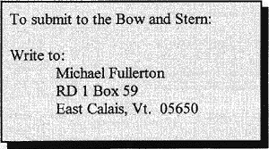
Bow and Stern
Summer 1998
The Official Newsletter of the Vermont Paddlers Club
| Volume ?, no. 2 |
|---|
| The President's Page |
|---|
The President allowed as how he had said 'most everthing he needed to say in a recent mailing. So there ain't nothing to be said here.
-ed.
| From the Editor |
|---|
So another paddling season has begun. As you see, there are a number of trip reports and a few other things, but not the flood of articles I hoped for. Let's have some input! Somebody out there must have done something adventurous on the water and be willing to write about it. I'd write myself but who wants to hear about a spring spent at home because of bruised ribs? (Failure to keep enough weight on the downhill ski during a turn)
How about some opinions? A safety discussion, notes on some conservation project, criticism, even a bad joke? (Did you hear the one about......) A news letter without news is boring. Get out your pens, keyboards, or dictaphones and write for this rag.
Send hard copy, e-mail or discs. MS Word & Word Perfect supported (and appreciated!)
Michael
![]()
| Trip Reports |
|---|
Huntington River : March 28, 1998
| Participants: | (K1): Jeff Collins, Darien McElwain, Megan O'Reilly, Michelle Seamans, Jay Strane; (OC1): Guy Bateman, Peter Downey, Mike Fullerton, Andy Meilleur, Merle Schloff, Tony Shaw |
There is a bridge just upstream of where Dugway Rd meets Huntington Rd that has a 5 gallon sized rock about 20 ft. upstream of the bridge. Tony Shaw showed me this rock as a water level gauge for the river and I have used it ever since. Medium level starts with the rock about 6" above water with a noticeable eddy. High level starts with water cresting over the rock. Very high level starts when the rock is submerged and forms a small surface wave. After that is flood. We had a warm day near 80 and the river was filled entirely by runoff. The level was high, rising to very high. We put in a bridge below Huntington Center and ran the river, finding washed out features and wave trains. There were many strainers, most of no consequence, but two near Dugway road were significant. There were several swims, all short, and after all, it was first time out for most of us.
-- Andy Meilleur
Waits River : March 29, 1998
| Participants: | (K1): Ricky Battistoni; (OC1): Peter Downey, Kevin Eaton, Peter Herman, Andy Meilleur |
The scheduled trip was the White, and I was caught between a flooded river and an uninspired alternative. Even the Tweed R. looked flooded. I had never seen the White like this and when we discussed our options Peter Herman admitted experience with the Waits R. It was only medium and could have handled another foot of water, I was glad to discover the busy stretches, play spots and challenging ledges which were run in assorted routes. Thanks to Peter Herman for saving this trip!!
-- Andy Meilleur
Mill Brook (Jericho) : March 29, 1998
| Participants: | (OC1): Eric Bishop, Tony Shaw |
We put in off Field Lane, off Nashville Rd, Jericho below the first big drop. Mill Brook is small, good water level at the time, but we couldn't have run it much lower. The stream features continuous class II- III, with a couple class Vs. There are lots of trees in the river and other obstructions, including a private hydro project. An 8 foot waterfall with no obvious route can be carried on the right. We took out at the rte. 117 bridge near Barber Farm Road. At a higher level this would be class IV-V. Worth doing.
-- Eric Bishop
Upper Lamoille : March 29, 1998
| Participants: | Randy Allen, Poppy Gall, Guy Bateman, Alan Rexford, Megan O'Reilly, Mike Fullerton |
| Water: | 4.25 feet (right in the fun range) |
Not a bad day weather wise, at least there was no ice on the gear. We ran the usual route from the bridge in Greensboro Bend to the village of Hardwick. There was only one major swim, that in the rapid below East Hardwick falls. Once again we were reminded of the difficulty of rescuing an open canoe in an active rapid. The paddler got out by the rules with no trouble. I found out that my skiing injury had not healed.
-- Mike Fullerton
Ammonoosuc River : April 5, 1998
| Participants: | (K1): Guy Bateman, Alan Rexford; (OC1): Randy Allen, Tom Jones, Andy Meilleur, Merle Schloff, Mike Smorgans |
| Water: | 3.3 ft. (medium-low) |
Well, the weatherman took away the sun and 5 degrees but at least gave us back a stiff wind and snow flurries. In response to concerns about cold and low water, I cut the trip short and put in at Pierce Bridge. We were soon warming up in Powerhouse rapid. The well known pink house that marks the head of Alder Brook rapid is now a dull gray. (And the landfill is cleaned up!!! -ed.)
-- Andy Meilleur
Dead Creek: April 18, 1998
| Participants: | George Agnew, John King, David Boedy & Jim Higgins |
We embarked at the Dead Creek parking area on route 17 on a windy Saturday morning. We were blessed with a steady south wind and often floated sideways to take advantage of it. A lunch stop in a side lead gave us wind cover. On the way back the south wind challenged our endurance. Fishermen lined the banks hopefully. We were tired but happy when we took out at the Panton road bridge.
-- George Agnew
Hudson Gorge : April 19, 1998
| Participants: | (OC1): Andy Meilleur, Tony Shaw, Mike Smorgans |
A dearth of water precluded today's scheduled New Haven R. trip, I suppose more would have joined us in NY had the alternate choice been something shorter and/or easier (e.g. the Schroon or lower Hudson). Despite the low levels this spring, the Hudson was at a respectable 4.8'
Halfway down the Indian we passed a raft contingent pausing to attend to an injured customer (dislocated shoulder), reminiscent of the rafter whose seizure we witnessed on the Indian last spring.
A short way from the confluence I crossed in front of a raft to drop into a tempting hole, spun, and surfed with flourish ... before capsizing. The prospect of a cold, difficult, and LONG swim was disconcerting -- truth is I didn't even know which shore was closer -- when the eager rafters above plucked me and my boat from the river! While emptying my canoe and returning me to the saddle they even invited me for drinks after the run. I've never been happier to see Hypalon!
We ran right at the narrows (uneventfully) and left at Harris Rift (where Andy uncharacteristically missed his line and shipped half-a-boatful of water). Mike did some cavalier side-surfing to the delight of all ... without dire consequences. Light rain started (as usual) near the trestle, and stayed light to the take-out. Shuttling, Mike pointed out the NYS troopers favorite places to lurk on the highway to Indian Lake. Leadfoots beware!!
Lower Lamoille: Wednesday evenings beginning April 22, 1998
| Leader: | Rich Larsen |
| Participants: | various |
Once again we did Wed. PM trips on the lower Lamoille from mid April to mid May. This year we were blessed with warm clear evenings on three of four trips, but water was low so trips were pretty tame. We saw beaver, ducks, killer geese (?) And maybe an osprey on various trips. 4/22: 13 boats, 17 people! 4/29: 8 boats, 8 people. 5/6: low water, canceled. 5/13: 4 boats, 4 people. Levels were mainly 800 - 1500 cfs. Readings are now available from the gauge near the 5 chutes.
-- Rich Larsen
Upper Winooski: April 25, 1998
| Participants: | George Agnew, John King, Dave Boedy, Jim Higgins |
An overcast day, we first scouted the Plainfield to E. Montpelier stretch of the river but decided to check out Marshfield. We eventually put in at the Public Library, one street over from Rte. 2. Although it was scratchy at first, we enjoyed the meandering turns, sometimes nearly 320 degrees- The bank erosion was surprising. Takeout was the Twinfield school parking lot. 6.5 miles, 3 hours.
-- George Agnew
Saranac River : April 26, 1998
| Leader: | Tony Shaw |
| Participants: | (OC1): Andy Meilleur, Tony Shaw, Mike Smorgans |
This was the most adventurous trip I went on this season, partly because it was a new river to me and partly because of the outstanding scenery and variety of water and land conditions. We met at Chimney Corner Park and Ride. The trip to the put-in took less than 2 hours and included the ferry ride and an unscheduled tour of Dannemora State Prison as seen from outside. The tree damage from the ice storm was severe in the area and we were concerned for debris in the river and on shore. There was an excess of posted land and the guidebook warned of several river access points in dispute. The attraction of the river, the prison, the No Trespassing signs and mangled trees produced a reaction felt in many adventures. We put in at user-friendly Union Falls Dam and headed down intermittent class II rapids through dense woodlands. Next came Tefft Pond, a mile long flat-water section with views of the surrounding mountains. We stopped for lunch and watched a dust devil hiss its way across the water. The only carry was Tefft Pond Falls, but it's a class IV carry made worse by the jumble of broken trees. I never swam, but fell twice! The trip ended after a three mile section that began like the Londonderry ledges on the West, and was as continuous as the East Branch of the Sacandaga. The water was just above low with the Silver Lake Road Bridge Gauge reading 1.75 and the Plattsburgh gauge at 4.7. The rapids on the last section were class II-III with a couple of III+. The Saranac has a long season and I want to go back when the water is higher.
-- Andy Meilleur
Upper Lamoille: May 2, 1998
| Participants: | George Agnew, John King, David Boedy & Jim Higgins |
We put in below Cady's Falls in Hyde Park on a rainy morning and paddled the gentle current of this scenic river. Double portage at Dog's Head Falls and a final take out on Hogback road by Rte 15 two and a half miles below Johnson. 7.5 miles, 4 hours.
-- George Agnew
Lower Hudson : May 10, 1998
| Participants: | (K1): Katy Hays; (OC1): Mike Fullerton, Rich Larson, Sheri Larson, Andy Meilleur |
| Water: | 4.5 feet |
We paddled in a continual light rain and drizzle. I found myself humming the Doors' "Riders on the Storm". Mike tested his recovery from a skiing injury at the Rock Island surfing wave.
-- Andy Meilleur
Hudson River: May 15-17, 1998
| Participants: | Agnew, King, Boedy and Higgins (a limited psychiatric corporation) |
A three day event starting with a drive to Chilson, N.Y. above Ticonderoga to put in at Putnam Pond State Park. We paddled 3/4 miles across the pond, stashed our boats and hiked Treadway Mtn (2250'). Five hours later we continued the journey to Riparius. With the Hudson too low on Saturday, we drove north and paddled the upper Schroon for nine miles. We capped the day with a hike up Severance Hill (1250'). With the Hudson still low on Sunday, we decided to paddle from the Glen down to Therman Station 11 miles below, The scenery was breathtaking, but the river wide and shallow.
-- George Agnew
Hudson Gorge : May 16, 1998
| Leader: | Rod Wentworth |
| Participants: | (OC-1): Andy Meilleur, Mike Smorgans, Bob Campbell; (K-1): Marvie Campbell, Eric Palmer, Rod Wentworth |
While the club has braved many a chilly day to paddle the Hudson Gorge in May, we were blessed with a much appreciated sunny day with air temperatures in the 80's. The water level as measured on the North Creek gauge was slightly below 4 feet - a level that, combined with the weather, encouraged paddlers to "go for it" at the bus stop and other play spots. Rafts were abundant but there were few other "hard" boaters. We started out ahead of most of the rafts but they caught up to us by the time we finished the Indian River. When we finally reached the bus stop wave, we were at the tail end of the rafts. Most of them stopped to play there, after which we had it mostly to ourselves. The level was friendly and both canoe and kayak paddlers enjoyed some good side surfing. We finished the day worn-out, but smiling in the warm sun! - Rod Wentworth
Rock River : May 28, 1998
| Leader: | Eric Bishop |
| Participants: | (OC1): Eric Bishop, Kevin Eaton, Randy Allen, Fred Glandsburg (did I get that right Fred?) |
A warm sunny day. We put in about 2 miles upstream from S. Newfane and planned to paddle to the confluence with the West, about 6 miles. The water was fairly high. The run to S. Newfane was uninterrupted class II-III. A large tributary doubled the size of the river in S. Newfane. The broken dam in Williamsville sits at the start of a long section of III-IV past the village. We lined the dam, and Fred broke a paddle in the drop below. After a run down the creek without a paddle he bailed out and made shore. After recovering the boat, we decided to call it a trip as the water had risen noticeably. This is definitely a river to try again.
-- Eric Bishop
| For Sale (A Vendre) |
|---|

|
Dagger Crossfire with paddles
  spray skirt and float bags.
  Used one season. $850
  Call Pat: 295-2866


Dagger Crossfire, spray skirt,
  back rest, float bags.  I'm too
  big for the boat. Used 7
  times. $550
  Call Clyde Yarnell

Sorry, I lost the phone No.
  Anybody know Clyde???
    -ed.
|
| Treasurer's Report - May 21, 1998 |
|---|
            General Fund


            Balance 2/28/98:           $ 280.52

                     Income:             966.73

                   Expenses:             741.51

            Balance 6/21/98:           $ 505.74


            Safety and Education Fund


            Balance 2/28/98:          $1,884.76

                     Income:             503.00

                   Expenses:           1,267.00

            Balance 6/21/98:          $1,120.76


             Treasury total:          $1,626.50
The erosion of the general fund seems to have ended with the added
income from the dues increase, but we will know better later in the year. The
reduction in safety and education is somewhat artificial, caused by the
accounting period, but $400.00 is real, the planned expenditure for a river rescue
class.
A full spread sheet with all expense and income is available on request.
Richard Larson, Treasurer
5/21/98
| American Whitewater Affiliation |
|---|
The American Whitewater Affiliation (AWA) is a national organization with a membership of almost 4,000 individual whitewater boating enthusiasts-sign-up!- -and more than 100 local paddling club affiliates. We are a non-profit organization whose work is done by lots of volunteers such as the regional coordinators, a few paid staff, and a board of directors.
Our activities fall into five main areas.
EDUCATION: Through publication of its magazine, American Whiftewater, and by other means, the AWA provides information and education about whitewater rivers, boating safety, technique, and equipment.
CONSERVATION: AWA maintains a complete national inventory of whitewater rivers. monitors threats to those rivers, publishes information on river conservation, provides technical advice to local groups, works with government agencies, and -- when necessary -- takes legal action to prevent river abuse.
EVENTS: AWA organizes sporting events, contests and festivals to raise funds for river conservation, including the Ocoee Whitewater Rodeo in Tennessee and the annual Gauley River Festival in West Virginia, the largest gathering of whitewater boaters in the nation.
SAFETY: AWA promotes paddling safety, publishes reports on whitewater accidents, and maintains both a uniform national ranking system for whitewater rivers (the International Scale of Whitewater Difficulty) as well as an internationally recognized whitewater safety code.
RIVER ACCESS: To assure public access to whitewater rivers AWA arranges for river access through private lands by negotiation or purchase, seeks to protect the right of public passage on all rivers and streams navigable by kayak or canoe, and resists unjustified restrictions on government-managed whitewater rivers.
AWA Whitewater Online, 19 November 1995.
Reprinted from the AWA website at http://www.americanwhitewater.org/
| Trips Schedule - Summer/Fall 1998 |
|---|
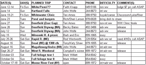
WW = whitewater /// FW = flatwater /// message phone: 899-1872 PIN 95 /// see schedule notes(below)
nov = max Class II, int = max Class III, adv = max Class IV, See Intl River Rating Scale
TRIP DIFFICULTY RATINGS ARE ONLY A GUIDE. READ GUIDELINES FOR VPC TRIPS.
STAY ASHORE WHEN CONDITIONS ON A GIVEN DAY EXCEED YOUR COMFORT LEVEL!!!!!!!!
- Contact the trip organizer for information about each trip. Listed trips may be changed or cancelled as water, weather, or interest dictates.
- Plans for impromptu trips can be relayed through the trip organizer , message phone, or online. Many fall trips (in particular) coalesce this way.
- We need a dozen or more experienced paddlers to make the June canoe and kayak school a success. Call Teri Ames (388-9750) to volunteer. Pre-clinic Instructors Workshops are planned for mid-June.
- Please give 1-2 weeks notice for overnight trips to have a say in tentsite/ menu pre-planning, etc. Car-pooling on long (and short) trips is encouraged!
- Tag along on one or more impromptu evening trip to play at Sumner Falls (Hartland VT) or below Middlesex Dam. John Wolfe (244-8673) , Rod Wentworth (229-5054), + others know these spots well.
- Check out Nova Scotia summer paddling a la Tim Yarrow (476-7972). Tidal bore, anyone?
- Call Susan and Peter Alden around Labor Day to learn of their plans for the annual Adirondack foliage overnight, and tag along. 863-6585.
- The AROUND VERMONT IN 30 RIVERS promotion is underway!!! Get details from any VPC officer, or online.
- Schedule posted now on the WWW (https://vtpaddlers.net/paddle/trips/index.php).